Bridge Statistics for North Valley Stream, New York (NY)
Condition, Traffic, Stress, Structural Evaluation, Project Costs
- National Bridge Inventory (NBI) Statistics
- 16Number of bridges
- 59ft / 18.3mTotal length
- $35,625,000Total costs
- 1,487,150Total average daily traffic
- 7,790Total average daily truck traffic
- National Bridge Inventory (NBI) Registered Bridges for North Valley Stream
- No street view available for this location
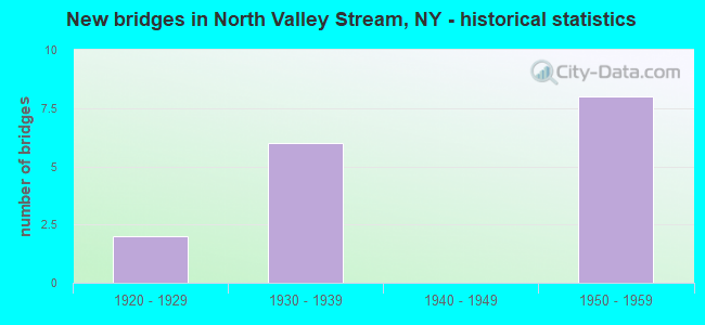
- New bridges - historical statistics
- 21920-1929
- 61930-1939
- 81950-1959
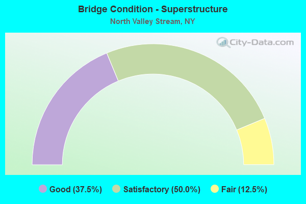
- Bridge Condition - Superstructure
- 37.5%Good
- 50.0%Satisfactory
- 12.5%Fair
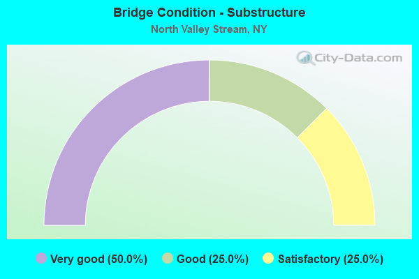
- Bridge Condition - Substructure
- 50.0%Very good
- 25.0%Good
- 25.0%Satisfactory
Find on map >> Show street view
Structure Number: 105932, Location: .2 MI E NYC L -SSP (Lat: 40.687994, Lng: -73.722922), Route carried "on" structure: Other road , Year Built: 1934, Status: Open, Structure Length: 2.71m (8.89ft), Average Daily Traffic: 20,549 (year 2019), Truck Traffic: 5%, Average Future Daily Traffic: 24,962 (year 2040), Design Load: H 20, Features Intersected: RTE 908M, Facility Carried by Structure: ELMONT ROAD
Minimum Vertical Clearance: 30+ m (98+ ft), Kilometerpoint: 0.563, Lanes on structure: 4, Lanes under structure: 4, Owner: State Highway Agency, Approaching Roadway Width: 13.1m (43.0ft), Skew: 4 degrees, Material/Design: Concrete, Design/Construction: Tee Beam, Number Of Spans In Main Unit: 1, Length of Maximum Span: 23.4m (76.8ft), Curb or Sidewalk Widths: Left: 1.5m (4.9ft), Right: 1.5m (4.9ft), Curb-To-Curb Width: 13.0m (42.7ft), Out-to-Out Width: 17.7m (58.1ft)
Condition: Deck: Satisfactory, Superstructure: Fair, Substructure: Satisfactory, Operating Rating: 63.0 metric tons, Method Used To Determine Operating Rating: Field evaluation and documented engineering judgment, Inventory Rating: 24.0 metric tons, Method Used To Determine Inventory Rating: Field evaluation and documented engineering judgment, Structural Evaluation: Somewhat better than minimum adequacy, Deck Geometry: High priority of replacement, Underclear: High priority of corrective action, Approach Roadway Alignment: Better than present minimum criteria, Length Of Structure Improvement: 2.71m (8.89ft), Designated Inspection Frequency: Every 24 months, Inspection Date: June 2021, Bridge Improvement Cost: $2,239,000, Roadway Improvement Cost: $1,311,000, Total Project Cost: $3,550,000 ( Estimate for 2021), Wearing Surface/Protective System: Wearing Surface: Integral Concrete
Find on map >> Show street view
Structure Number: 1059331, Location: .6 MI E NYC LINE & SSP (Lat: 40.686872, Lng: -73.715458), Route carried "on" structure: State highway 908M, Year Built: 1956, Status: Open, Structure Length: 2.01m (6.59ft), Average Daily Traffic: 85,940 (year 2019), Truck Traffic: 2%, Average Future Daily Traffic: 102,225 (year 2040), Design Load: HS 20, Features Intersected: CENTRAL AVENUE
Minimum Vertical Clearance: 30+ m (98+ ft), Kilometerpoint: 1.014, Lanes on structure: 4, Lanes under structure: 2, Base Highway Network: Yes, Owner: State Highway Agency, Approaching Roadway Width: 15.2m (49.9ft), Skew: 4 degrees, Material/Design: Concrete, Design/Construction: Frame, Number Of Spans In Main Unit: 1, Length of Maximum Span: 18.2m (59.7ft), Curb-To-Curb Width: 15.3m (50.2ft), Out-to-Out Width: 18.1m (59.4ft)
Condition: Deck: Satisfactory, Superstructure: Satisfactory, Substructure: Very good, Operating Rating: 85.6 metric tons, Method Used To Determine Operating Rating: Field evaluation and documented engineering judgment, Inventory Rating: 32.7 metric tons, Method Used To Determine Inventory Rating: Field evaluation and documented engineering judgment, Structural Evaluation: Equal to present minimum criteria, Deck Geometry: High priority of replacement, Underclear: High priority of corrective action, Approach Roadway Alignment: Better than present minimum criteria, Length Of Structure Improvement: 2.01m (6.59ft), Designated Inspection Frequency: Every 24 months, Inspection Date: October 2020, Bridge Improvement Cost: $2,913,000, Roadway Improvement Cost: $1,706,000, Total Project Cost: $4,618,000 ( Estimate for 2021)
Find on map >> Show street view
Structure Number: 1059332, Location: .6 MI E NYC LINE & SSP (Lat: 40.686678, Lng: -73.715303), Route carried "on" structure: State highway 908M, Year Built: 1934, Status: Open, Structure Length: 1.86m (6.10ft), Average Daily Traffic: 85,940 (year 2019), Truck Traffic: 2%, Average Future Daily Traffic: 102,225 (year 2040), Design Load: H 20, Features Intersected: CENTRAL AVENUE
Minimum Vertical Clearance: 30+ m (98+ ft), Kilometerpoint: 1.014, Lanes on structure: 4, Lanes under structure: 2, Base Highway Network: Yes, Owner: State Highway Agency, Approaching Roadway Width: 15.2m (49.9ft), Skew: 4 degrees, Material/Design: Concrete, Design/Construction: Frame, Number Of Spans In Main Unit: 1, Length of Maximum Span: 17.6m (57.7ft), Curb-To-Curb Width: 15.3m (50.2ft), Out-to-Out Width: 17.1m (56.1ft)
Condition: Deck: Satisfactory, Superstructure: Satisfactory, Substructure: Very good, Operating Rating: 56.1 metric tons, Method Used To Determine Operating Rating: Field evaluation and documented engineering judgment, Inventory Rating: 22.4 metric tons, Method Used To Determine Inventory Rating: Field evaluation and documented engineering judgment, Structural Evaluation: Somewhat better than minimum adequacy, Deck Geometry: High priority of replacement, Underclear: High priority of corrective action, Approach Roadway Alignment: Better than present minimum criteria, Length Of Structure Improvement: 1.85m (6.07ft), Designated Inspection Frequency: Every 24 months, Inspection Date: October 2020, Bridge Improvement Cost: $2,395,000, Roadway Improvement Cost: $1,402,000, Total Project Cost: $3,797,000 ( Estimate for 2021), Wearing Surface/Protective System: Wearing Surface: Bituminous, Membrane: Preformed Fabric
Find on map >> Show street view
Structure Number: 105935, Location: 1.5 MI E NYC LINE ON SSP (Lat: 40.679031, Lng: -73.700192), Route carried "on" structure: Other road , Year Built: 1934, Status: Open, Structure Length: 1.98m (6.50ft), Average Daily Traffic: 12,086 (year 2020), Truck Traffic: 1%, Average Future Daily Traffic: 14,954 (year 2040), Features Intersected: RTE 908M, Facility Carried by Structure: FLETCHER AVENUE
Minimum Vertical Clearance: 30+ m (98+ ft), Kilometerpoint: 0.274, Lanes on structure: 2, Lanes under structure: 4, Owner: State Highway Agency, Approaching Roadway Width: 12.2m (40.0ft), Skew: 1 degrees, Material/Design: Concrete, Design/Construction: Arch - Deck, Number Of Spans In Main Unit: 1, Length of Maximum Span: 18.5m (60.7ft), Curb or Sidewalk Widths: Left: 1.5m (4.9ft), Right: 1.5m (4.9ft), Curb-To-Curb Width: 12.2m (40.0ft), Out-to-Out Width: 17.1m (56.1ft)
Condition: Superstructure: Satisfactory, Substructure: Satisfactory, Operating Rating: 56.2 metric tons, Method Used To Determine Operating Rating: Field evaluation and documented engineering judgment, Inventory Rating: 20.3 metric tons, Method Used To Determine Inventory Rating: Field evaluation and documented engineering judgment, Structural Evaluation: Somewhat better than minimum adequacy, Deck Geometry: Somewhat better than minimum adequacy, Underclear: High priority of corrective action, Approach Roadway Alignment: Better than present minimum criteria, Length Of Structure Improvement: 1.98m (6.50ft), Designated Inspection Frequency: Every 24 months, Inspection Date: June 2021, Bridge Improvement Cost: $2,858,000, Roadway Improvement Cost: $1,673,000, Total Project Cost: $4,531,000 ( Estimate for 2021), Wearing Surface/Protective System: Wearing Surface: Bituminous
Find on map >> Show street view
Structure Number: 105936, Location: 2.1 MI E NYC LINE & SSP (Lat: 40.682956, Lng: -73.688486), Route carried "on" structure: County highway , Year Built: 1956, Status: Open, Structure Length: 2.59m (8.50ft), Average Daily Traffic: 20,602 (year 2018), Truck Traffic: 5%, Average Future Daily Traffic: 25,027 (year 2040), Design Load: HS 20, Features Intersected: RTE 908M, Facility Carried by Structure: CORONA AVENUE
Minimum Vertical Clearance: 30+ m (98+ ft), Kilometerpoint: 2.188, Lanes on structure: 4, Lanes under structure: 4, Owner: State Highway Agency, Approaching Roadway Width: 12.8m (42.0ft), Skew: 3 degrees, Material/Design: Concrete, Design/Construction: Arch - Deck, Number Of Spans In Main Unit: 1, Length of Maximum Span: 25.6m (84.0ft), Curb or Sidewalk Widths: Left: 1.2m (3.9ft), Right: 1.2m (3.9ft), Curb-To-Curb Width: 12.8m (42.0ft), Out-to-Out Width: 16.2m (53.1ft)
Condition: Superstructure: Good, Substructure: Good, Operating Rating: 89.0 metric tons, Method Used To Determine Operating Rating: Field evaluation and documented engineering judgment, Inventory Rating: 29.4 metric tons, Method Used To Determine Inventory Rating: Field evaluation and documented engineering judgment, Structural Evaluation: Better than present minimum criteria, Deck Geometry: High priority of replacement, Underclear: High priority of corrective action, Approach Roadway Alignment: Equal to present desirable criteria, Length Of Structure Improvement: 2.59m (8.50ft), Designated Inspection Frequency: Every 24 months, Inspection Date: December 2020, Bridge Improvement Cost: $3,218,000, Roadway Improvement Cost: $1,885,000, Total Project Cost: $5,103,000 ( Estimate for 2021), Wearing Surface/Protective System: Wearing Surface: Bituminous
Find on map >> Show street view
Structure Number: 152016, Location: .2 MI E NYC L -SSP (Lat: 40.688250, Lng: -73.722756), Route carried "on" structure: County highway , Year Built: 1956, Status: Open, Structure Length: 2.59m (8.50ft), Average Daily Traffic: 20,549 (year 2019), Truck Traffic: 5%, Average Future Daily Traffic: 24,962 (year 2040), Design Load: HS 20, Features Intersected: RTE 908M, Facility Carried by Structure: ELMONT ROAD
Minimum Vertical Clearance: 30+ m (98+ ft), Kilometerpoint: 0.595, Lanes on structure: 4, Lanes under structure: 4, Owner: State Highway Agency, Approaching Roadway Width: 13.1m (43.0ft), Skew: 4 degrees, Material/Design: Concrete, Design/Construction: Frame, Number Of Spans In Main Unit: 1, Length of Maximum Span: 23.7m (77.8ft), Curb or Sidewalk Widths: Left: 1.5m (4.9ft), Right: 1.5m (4.9ft), Curb-To-Curb Width: 13.0m (42.7ft), Out-to-Out Width: 17.7m (58.1ft)
Condition: Deck: Satisfactory, Superstructure: Good, Substructure: Very good, Operating Rating: 89.5 metric tons, Method Used To Determine Operating Rating: Field evaluation and documented engineering judgment, Inventory Rating: 32.7 metric tons, Method Used To Determine Inventory Rating: Field evaluation and documented engineering judgment, Structural Evaluation: Better than present minimum criteria, Deck Geometry: High priority of replacement, Underclear: High priority of corrective action, Approach Roadway Alignment: Better than present minimum criteria, Length Of Structure Improvement: 2.59m (8.50ft), Designated Inspection Frequency: Every 24 months, Inspection Date: March 2021, Bridge Improvement Cost: $3,023,000, Roadway Improvement Cost: $1,770,000, Total Project Cost: $4,792,000 ( Estimate for 2021), Wearing Surface/Protective System: Wearing Surface: Integral Concrete
Find on map >> Show street view
Structure Number: 152017, Location: 1.5 MI E NYC LINE ON SSP (Lat: 40.679272, Lng: -73.700233), Route carried "on" structure: Other road , Year Built: 1956, Status: Open, Structure Length: 2.32m (7.61ft), Average Daily Traffic: 12,086 (year 2020), Truck Traffic: 1%, Average Future Daily Traffic: 14,954 (year 2040), Design Load: HS 20, Features Intersected: RTE 908M, Facility Carried by Structure: NORTH FLETCHER AVE
Minimum Vertical Clearance: 30+ m (98+ ft), Kilometerpoint: 0.306, Lanes on structure: 2, Lanes under structure: 4, Owner: State Highway Agency, Approaching Roadway Width: 12.2m (40.0ft), Skew: 1 degrees, Material/Design: Concrete, Design/Construction: Arch - Deck, Number Of Spans In Main Unit: 1, Length of Maximum Span: 21.6m (70.9ft), Curb or Sidewalk Widths: Left: 1.5m (4.9ft), Right: 1.5m (4.9ft), Curb-To-Curb Width: 12.3m (40.4ft), Out-to-Out Width: 17.7m (58.1ft)
Condition: Superstructure: Satisfactory, Substructure: Very good, Operating Rating: 86.5 metric tons, Method Used To Determine Operating Rating: Field evaluation and documented engineering judgment, Inventory Rating: 29.4 metric tons, Method Used To Determine Inventory Rating: Field evaluation and documented engineering judgment, Structural Evaluation: Equal to present minimum criteria, Deck Geometry: Somewhat better than minimum adequacy, Underclear: High priority of corrective action, Approach Roadway Alignment: Equal to present desirable criteria, Length Of Structure Improvement: 2.31m (7.58ft), Designated Inspection Frequency: Every 24 months, Inspection Date: May 2021, Bridge Improvement Cost: $3,370,000, Roadway Improvement Cost: $1,974,000, Total Project Cost: $5,344,000 ( Estimate for 2021), Wearing Surface/Protective System: Wearing Surface: Bituminous
Find on map >> Show street view
Structure Number: 152018, Location: 2.1 NI E NYC LINE & SSP (Lat: 40.683258, Lng: -73.688356), Route carried "on" structure: County highway , Year Built: 1929, Status: Open, Structure Length: 2.26m (7.41ft), Average Daily Traffic: 20,602 (year 2018), Truck Traffic: 5%, Average Future Daily Traffic: 25,027 (year 2040), Features Intersected: RTE 908M, Facility Carried by Structure: CORONA AVE
Minimum Vertical Clearance: 30+ m (98+ ft), Kilometerpoint: 2.253, Lanes on structure: 4, Lanes under structure: 4, Owner: State Highway Agency, Approaching Roadway Width: 12.8m (42.0ft), Skew: 2 degrees, Material/Design: Concrete, Design/Construction: Arch - Deck, Number Of Spans In Main Unit: 1, Length of Maximum Span: 22.3m (73.2ft), Curb or Sidewalk Widths: Left: 1.2m (3.9ft), Right: 1.2m (3.9ft), Curb-To-Curb Width: 12.8m (42.0ft), Out-to-Out Width: 16.2m (53.1ft)
Condition: Superstructure: Good, Substructure: Good, Operating Rating: 45.3 metric tons, Method Used To Determine Operating Rating: Field evaluation and documented engineering judgment, Inventory Rating: 16.0 metric tons, Method Used To Determine Inventory Rating: Field evaluation and documented engineering judgment, Structural Evaluation: High priority of corrective action, Deck Geometry: High priority of replacement, Underclear: High priority of corrective action, Approach Roadway Alignment: Equal to present desirable criteria, Length Of Structure Improvement: 2.25m (7.38ft), Designated Inspection Frequency: Every 24 months, Inspection Date: December 2020, Bridge Improvement Cost: $2,454,000, Roadway Improvement Cost: $1,437,000, Total Project Cost: $3,890,000 ( Estimate for 2021), Wearing Surface/Protective System: Wearing Surface: Bituminous
Find on map >> Show street view
Structure Number: 105932, Location: .2 MI E NYC L -SSP (Lat: 40.687994, Lng: -73.722922), Route carried "under" structure: State highway 908M, Year Built: 1934, Structure Length: 0. m, Average Daily Traffic: 176,004 (year 2002), Features Intersected: RTE 908M, Facility Carried by Structure: ELMONT ROAD
Minimum Vertical Clearance: 4.14m (13.58ft), Kilometerpoint: 0.322, Lanes on structure: 4, Lanes under structure: 4, Material/Design: Concrete, Design/Construction: Tee Beam, Length of Maximum Span: 23.4m (76.8ft)
Find on map >> Show street view
Structure Number: 1059331, Location: .6 MI E NYC LINE & SSP (Lat: 40.686872, Lng: -73.715458), Route carried "under" structure: County highway , Year Built: 1956, Structure Length: 0. m, Average Daily Traffic: 19,866 (year 2001), Features Intersected: CENTRAL AVENUE, Facility Carried by Structure: RTE 908M
Minimum Vertical Clearance: 4.50m (14.76ft), Kilometerpoint: 0.000, Lanes on structure: 4, Lanes under structure: 2, Material/Design: Concrete, Design/Construction: Frame, Length of Maximum Span: 18.2m (59.7ft)
Find on map >> Show street view
Structure Number: 1059332, Location: .6 MI E NYC LINE & SSP (Lat: 40.686678, Lng: -73.715303), Route carried "under" structure: County highway , Year Built: 1934, Structure Length: 0. m, Average Daily Traffic: 19,866 (year 2001), Features Intersected: CENTRAL AVENUE, Facility Carried by Structure: RTE 908M
Minimum Vertical Clearance: 4.82m (15.81ft), Kilometerpoint: 0.000, Lanes on structure: 4, Lanes under structure: 2, Material/Design: Concrete, Design/Construction: Frame, Length of Maximum Span: 17.6m (57.7ft)
Find on map >> Show street view
Structure Number: 105935, Location: 1.5 MI E NYC LINE ON SSP (Lat: 40.679031, Lng: -73.700192), Route carried "under" structure: State highway 908M, Year Built: 1934, Structure Length: 0. m, Average Daily Traffic: 198,907 (year 2002), Features Intersected: RTE 908M, Facility Carried by Structure: FLETCHER AVENUE
Minimum Vertical Clearance: 4.19m (13.75ft), Kilometerpoint: 2.574, Lanes on structure: 2, Lanes under structure: 4, Material/Design: Concrete, Design/Construction: Arch - Deck, Length of Maximum Span: 18.5m (60.7ft)
Find on map >> Show street view
Structure Number: 105936, Location: 2.1 MI E NYC LINE & SSP (Lat: 40.682956, Lng: -73.688486), Route carried "under" structure: State highway 908M, Year Built: 1956, Structure Length: 0. m, Average Daily Traffic: 209,621 (year 2002), Features Intersected: RTE 908M, Facility Carried by Structure: CORONA AVENUE
Minimum Vertical Clearance: 3.96m (12.99ft), Kilometerpoint: 3.685, Lanes on structure: 4, Lanes under structure: 4, Material/Design: Concrete, Design/Construction: Arch - Deck, Length of Maximum Span: 25.6m (84.0ft)
Find on map >> Show street view
Structure Number: 152016, Location: .2 MI E NYC L -SSP (Lat: 40.688250, Lng: -73.722756), Route carried "under" structure: State highway 908M, Year Built: 1956, Structure Length: 0. m, Average Daily Traffic: 176,004 (year 2002), Features Intersected: RTE 908M, Facility Carried by Structure: ELMONT ROAD
Minimum Vertical Clearance: 4.26m (13.98ft), Kilometerpoint: 0.322, Lanes on structure: 4, Lanes under structure: 4, Material/Design: Concrete, Design/Construction: Frame, Length of Maximum Span: 23.7m (77.8ft)
Find on map >> Show street view
Structure Number: 152017, Location: 1.5 MI E NYC LINE ON SSP (Lat: 40.679272, Lng: -73.700233), Route carried "under" structure: State highway 908M, Year Built: 1956, Structure Length: 0. m, Average Daily Traffic: 198,907 (year 2002), Features Intersected: RTE 908M, Facility Carried by Structure: NORTH FLETCHER AVE
Minimum Vertical Clearance: 4.04m (13.25ft), Kilometerpoint: 2.574, Lanes on structure: 2, Lanes under structure: 4, Material/Design: Concrete, Design/Construction: Arch - Deck, Length of Maximum Span: 21.6m (70.9ft)
Find on map >> Show street view
Structure Number: 152018, Location: 2.1 NI E NYC LINE & SSP (Lat: 40.683258, Lng: -73.688356), Route carried "under" structure: State highway 908M, Year Built: 1929, Structure Length: 0. m, Average Daily Traffic: 209,621 (year 2002), Features Intersected: RTE 908M, Facility Carried by Structure: CORONA AVE
Minimum Vertical Clearance: 3.96m (12.99ft), Kilometerpoint: 3.685, Lanes on structure: 4, Lanes under structure: 4, Material/Design: Concrete, Design/Construction: Arch - Deck, Length of Maximum Span: 22.3m (73.2ft)