Bridge Statistics for North Miami Beach, Florida (FL)
Condition, Traffic, Stress, Structural Evaluation, Project Costs
- National Bridge Inventory (NBI) Statistics
- 25Number of bridges
- 394ft / 120mTotal length
- 799,945Total average daily traffic
- 39,642Total average daily truck traffic
- National Bridge Inventory (NBI) Registered Bridges for North Miami Beach
- No street view available for this location
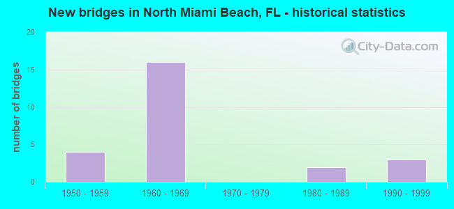
- New bridges - historical statistics
- 41950-1959
- 161960-1969
- 21980-1989
- 31990-1999

- Reconstructed bridges - Historical Statistics
- 21980-1989
- 31990-1999


- Bridge Condition - Deck
- 92.9%Good
- 7.1%Satisfactory

- Bridge Condition - Superstructure
- 71.4%Good
- 14.3%Satisfactory
- 7.1%Fair
- 7.1%Poor

- Bridge Condition - Substructure
- 85.7%Good
- 7.1%Satisfactory
- 7.1%Fair

- Bridge Condition - Channel
- 40.0%Very good
- 30.0%Good
- 10.0%Satisfactory
- 10.0%Fair
- 10.0%Poor
Find on map >> Show street view
Structure Number: 870243, Location: SR7 NB G. GLADES (Lat: 25.931017, Lng: -80.204778), Route carried "on" structure: US 441, Year Built: 1963, Status: Open, Structure Length: 22.68m (74.41ft), Average Daily Traffic: 34,000 (year 2020), Truck Traffic: 5%, Average Future Daily Traffic: 58,990 (year 2042), Design Load: HS 20, Features Intersected: I-95 FEC RR 2ND AVE
Minimum Vertical Clearance: 5.50m (18.04ft), Kilometerpoint: 18.908, Lanes on structure: 2, Lanes under structure: 11, Base Highway Network: Yes, Owner: State Highway Agency, Approaching Roadway Width: 8.6m (28.2ft), Skew: 3 degrees, Material/Design: Steel, Design/Construction: Stringer/Multi-beam, Number Of Spans In Main Unit: 2, Number Of Approach Spans: 7, Length of Maximum Span: 47.9m (157.2ft), Curb or Sidewalk Widths: Left: 0.3m (1.0ft), Right: 0.3m (1.0ft), Curb-To-Curb Width: 8.6m (28.2ft), Out-to-Out Width: 10.4m (34.1ft)
Condition: Deck: Good, Superstructure: Good, Substructure: Good, Operating Rating: 41.2 metric tons, Method Used To Determine Operating Rating: Load Factor (LF), Inventory Rating: 26.9 metric tons, Method Used To Determine Inventory Rating: Load Factor (LF), Structural Evaluation: Equal to present minimum criteria, Deck Geometry: High priority of corrective action, Underclear: High priority of corrective action, Approach Roadway Alignment: Better than present minimum criteria, Designated Inspection Frequency: Every 24 months, Inspection Date: June 2021, Deck Structure Type: Concrete Cast-file-Place, Wearing Surface/Protective System: Wearing Surface: Integral Concrete
Find on map >> Show street view
Structure Number: 870352, Location: AT NW 183RD ST (Lat: 25.941853, Lng: -80.189406), Route carried "on" structure: Interstate 95, Year Built: 1962, Year Reconstructed: 1988, Status: Open, Structure Length: 25.59m (83.96ft), Average Daily Traffic: 91,500 (year 2019), Truck Traffic: 4%, Average Future Daily Traffic: 158,752 (year 2041), Design Load: HS 20, Features Intersected: SR-860 & I-95 SB RAMPS
Minimum Vertical Clearance: 30+ m (98+ ft), Kilometerpoint: 4.426, Lanes on structure: 6, Lanes under structure: 13, Base Highway Network: Yes, Owner: State Highway Agency, Approaching Roadway Width: 24.0m (78.7ft), Skew: 9 degrees, Material/Design: Prestressed concrete, Design/Construction: Stringer/Multi-beam, Number Of Spans In Main Unit: 11, Length of Maximum Span: 29.6m (97.1ft), Curb-To-Curb Width: 24.0m (78.7ft), Out-to-Out Width: 24.9m (81.7ft)
Condition: Deck: Good, Superstructure: Good, Substructure: Good, Operating Rating: 54.2 metric tons, Method Used To Determine Operating Rating: Load Factor (LF), Inventory Rating: 29.1 metric tons, Method Used To Determine Inventory Rating: Load Factor (LF), Structural Evaluation: Better than present minimum criteria, Deck Geometry: Meets minimum limits, Underclear: High priority of corrective action, Approach Roadway Alignment: Equal to present desirable criteria, Designated Inspection Frequency: Every 24 months, Inspection Date: March 2020, Deck Structure Type: Concrete Cast-file-Place
Find on map >> Show street view
Structure Number: 870449, Location: AT NW 183RD ST. (Lat: 25.941689, Lng: -80.189267), Route carried "on" structure: Interstate 95, Year Built: 1962, Year Reconstructed: 1988, Status: Open, Structure Length: 19.84m (65.09ft), Average Daily Traffic: 109,500 (year 2020), Truck Traffic: 5%, Average Future Daily Traffic: 189,982 (year 2042), Design Load: HS 20, Features Intersected: SR-860 & I-95 SB RAMPS
Minimum Vertical Clearance: 30+ m (98+ ft), Kilometerpoint: 23.197, Lanes on structure: 4, Lanes under structure: 13, Base Highway Network: Yes, Owner: State Highway Agency, Approaching Roadway Width: 21.5m (70.5ft), Skew: 9 degrees, Material/Design: Prestressed concrete, Design/Construction: Stringer/Multi-beam, Number Of Spans In Main Unit: 8, Length of Maximum Span: 29.6m (97.1ft), Curb-To-Curb Width: 21.5m (70.5ft), Out-to-Out Width: 22.4m (73.5ft)
Condition: Deck: Good, Superstructure: Good, Substructure: Good, Operating Rating: 60.2 metric tons, Method Used To Determine Operating Rating: Load Factor (LF), Inventory Rating: 36.2 metric tons, Method Used To Determine Inventory Rating: Load Factor (LF), Structural Evaluation: Better than present minimum criteria, Deck Geometry: Better than present minimum criteria, Underclear: High priority of corrective action, Approach Roadway Alignment: Equal to present desirable criteria, Designated Inspection Frequency: Every 24 months, Inspection Date: March 2020, Deck Structure Type: Concrete Cast-file-Place
Find on map >> Show street view
Structure Number: 870622, Location: 0.5M W OF SR-5 (Lat: 25.947175, Lng: -80.155025), Route carried "on" structure: Alternate State highway 860, Year Built: 1968, Status: Open, Structure Length: 3.66m (12.01ft), Average Daily Traffic: 16,500 (year 2020), Truck Traffic: 5%, Average Future Daily Traffic: 28,628 (year 2042), Design Load: HS 20, Features Intersected: OLETA RIVER
Minimum Vertical Clearance: 30+ m (98+ ft), Kilometerpoint: 14.183, Lanes on structure: 2, Owner: State Highway Agency, Approaching Roadway Width: 9.4m (30.8ft), Material/Design: Prestressed concrete, Design/Construction: Slab, Number Of Spans In Main Unit: 3, Length of Maximum Span: 12.2m (40.0ft), Curb or Sidewalk Widths: Left: 0.0m, Right: 1.7m (5.6ft), Curb-To-Curb Width: 9.4m (30.8ft), Out-to-Out Width: 12.0m (39.4ft)
Condition: Deck: Satisfactory, Superstructure: Satisfactory, Substructure: Good, Channel: Good, Operating Rating: 77.3 metric tons, Method Used To Determine Operating Rating: Load Factor (LF), Inventory Rating: 46.4 metric tons, Method Used To Determine Inventory Rating: Load Factor (LF), Structural Evaluation: Equal to present minimum criteria, Deck Geometry: Meets minimum limits, Waterway Adequacy: Equal to present desirable criteria, Approach Roadway Alignment: Equal to present desirable criteria, Designated Inspection Frequency: Every 24 months, Underwater Inspection Frequency: Every 24 months, Inspection Date: April 2021, Underwater Inspection Date: April 2021, Deck Structure Type: Concrete Precast Panels, Wearing Surface/Protective System: Wearing Surface: Bituminous
Find on map >> Show street view
Structure Number: 870623, Location: NE 183 St. / NE 11 Ave. (Lat: 25.944092, Lng: -80.180386), Route carried "on" structure: State highway 860, Year Built: 1968, Year Reconstructed: 1997, Status: Open, Structure Length: 4.77m (15.65ft), Average Daily Traffic: 23,250 (year 2020), Truck Traffic: 4%, Average Future Daily Traffic: 40,339 (year 2042), Design Load: HS 20, Features Intersected: SNAKE CREEK CANAL C-9
Minimum Vertical Clearance: 30+ m (98+ ft), Kilometerpoint: 11.541, Lanes on structure: 2, Owner: State Highway Agency, Approaching Roadway Width: 11.2m (36.7ft), Material/Design: Prestressed concrete, Design/Construction: Slab, Number Of Spans In Main Unit: 4, Length of Maximum Span: 13.4m (44.0ft), Curb or Sidewalk Widths: Left: 1.6m (5.2ft), Right: 0.0m, Curb-To-Curb Width: 9.3m (30.5ft), Out-to-Out Width: 11.8m (38.7ft)
Condition: Deck: Good, Superstructure: Good, Substructure: Good, Channel: Very good, Operating Rating: 54.5 metric tons, Method Used To Determine Operating Rating: Load Factor (LF), Inventory Rating: 32.7 metric tons, Method Used To Determine Inventory Rating: Load Factor (LF), Structural Evaluation: Better than present minimum criteria, Deck Geometry: Meets minimum limits, Waterway Adequacy: Equal to present desirable criteria, Approach Roadway Alignment: Equal to present desirable criteria, Designated Inspection Frequency: Every 24 months, Underwater Inspection Frequency: Every 24 months, Inspection Date: Febuary 2022, Underwater Inspection Date: Febuary 2022, Deck Structure Type: Concrete Precast Panels, Wearing Surface/Protective System: Wearing Surface: Bituminous
Find on map >> Show street view
Structure Number: 870624, Location: NE 183 st / NE 11 Ave. (Lat: 25.943967, Lng: -80.180267), Route carried "on" structure: State highway 860, Year Built: 1956, Year Reconstructed: 1997, Status: Open, Structure Length: 4.14m (13.58ft), Average Daily Traffic: 23,250 (year 2020), Truck Traffic: 4%, Average Future Daily Traffic: 40,339 (year 2042), Design Load: HS 20, Features Intersected: SNAKE CREEK CANAL C-9
Minimum Vertical Clearance: 30+ m (98+ ft), Kilometerpoint: 11.541, Lanes on structure: 2, Owner: State Highway Agency, Approaching Roadway Width: 11.5m (37.7ft), Material/Design: Steel, Design/Construction: Stringer/Multi-beam, Number Of Spans In Main Unit: 4, Length of Maximum Span: 10.4m (34.1ft), Curb or Sidewalk Widths: Left: 0.0m, Right: 1.5m (4.9ft), Curb-To-Curb Width: 9.1m (29.9ft), Out-to-Out Width: 11.5m (37.7ft)
Condition: Deck: Good, Superstructure: Satisfactory, Substructure: Good, Channel: Very good, Operating Rating: 35.4 metric tons, Method Used To Determine Operating Rating: Load and Resistance Factor (LRFR), Inventory Rating: 27.3 metric tons, Method Used To Determine Inventory Rating: Load and Resistance Factor (LRFR), Structural Evaluation: Equal to present minimum criteria, Deck Geometry: Meets minimum limits, Waterway Adequacy: Equal to present desirable criteria, Approach Roadway Alignment: Equal to present desirable criteria, Designated Inspection Frequency: Every 24 months, Underwater Inspection Frequency: Every 24 months, Inspection Date: Febuary 2022, Underwater Inspection Date: Febuary 2022, Deck Structure Type: Concrete Cast-file-Place, Wearing Surface/Protective System: Wearing Surface: Bituminous
Find on map >> Show street view
Structure Number: 870642, Location: 826 OVER RR (NW 167TH ST) (Lat: 25.928139, Lng: -80.208931), Route carried "on" structure: State highway 826, Year Built: 1986, Status: Open, Structure Length: 6.11m (20.05ft), Average Daily Traffic: 49,500 (year 2020), Truck Traffic: 4%, Average Future Daily Traffic: 85,882 (year 2042), Design Load: HS 20, Features Intersected: CSX R/R & NW 167TH ST
Minimum Vertical Clearance: 30+ m (98+ ft), Kilometerpoint: 0.187, Lanes on structure: 5, Lanes under structure: 2, Base Highway Network: Yes, Owner: State Highway Agency, Approaching Roadway Width: 26.6m (87.3ft), Skew: 30 degrees, Material/Design: Steel, Design/Construction: Stringer/Multi-beam, Number Of Spans In Main Unit: 1, Number Of Approach Spans: 3, Length of Maximum Span: 17.6m (57.7ft), Curb-To-Curb Width: 26.6m (87.3ft), Out-to-Out Width: 27.7m (90.9ft)
Condition: Deck: Good, Superstructure: Good, Substructure: Good, Operating Rating: 72.9 metric tons, Method Used To Determine Operating Rating: Load Factor (LF), Inventory Rating: 43.7 metric tons, Method Used To Determine Inventory Rating: Load Factor (LF), Structural Evaluation: Better than present minimum criteria, Deck Geometry: Superior to present desirable criteria, Underclear: Meets minimum limits, Approach Roadway Alignment: Equal to present desirable criteria, Designated Inspection Frequency: Every 24 months, Inspection Date: April 2021, Deck Structure Type: Concrete Cast-file-Place
Find on map >> Show street view
Structure Number: 870746, Location: .3m N of N.E. 163 St. (Lat: 25.928997, Lng: -80.153042), Route carried "on" structure: US U.S.1, Year Built: 1998, Status: Open, Structure Length: 5.40m (17.72ft), Average Daily Traffic: 26,500 (year 2020), Truck Traffic: 3%, Average Future Daily Traffic: 45,978 (year 2042), Design Load: HL 93, Features Intersected: Snake Cr Canal, Facility Carried by Structure: U.S. 1 SB
Minimum Vertical Clearance: 30.45m (99.90ft), Kilometerpoint: 35.607, Lanes on structure: 4, Base Highway Network: Yes, Owner: State Highway Agency, Approaching Roadway Width: 16.5m (54.1ft), Skew: 7 degrees, Material/Design: Prestressed concrete, Design/Construction: Stringer/Multi-beam, Number Of Spans In Main Unit: 3, Length of Maximum Span: 18.0m (59.1ft), Curb or Sidewalk Widths: Left: 2.0m (6.6ft), Right: 0.0m, Curb-To-Curb Width: 16.5m (54.1ft), Out-to-Out Width: 19.4m (63.6ft)
Condition: Deck: Good, Superstructure: Good, Substructure: Good, Channel: Very good, Operating Rating: 62.4 metric tons, Method Used To Determine Operating Rating: Load and Resistance Factor (LRFR), Inventory Rating: 43.5 metric tons, Method Used To Determine Inventory Rating: Load and Resistance Factor (LRFR), Structural Evaluation: Better than present minimum criteria, Deck Geometry: Meets minimum limits, Waterway Adequacy: Equal to present desirable criteria, Approach Roadway Alignment: Better than present minimum criteria, Designated Inspection Frequency: Every 24 months, Underwater Inspection Frequency: Every 24 months, Inspection Date: Febuary 2021, Underwater Inspection Date: Febuary 2021, Deck Structure Type: Concrete Cast-file-Place, Wearing Surface/Protective System: Wearing Surface: Monolithic Concrete
Find on map >> Show street view
Structure Number: 870799, Location: 0.2M N OF NW 119 ST. (Lat: 25.886417, Lng: -80.191083), Route carried "on" structure: Alternate State highway 909, Year Built: 1996, Status: Open, Structure Length: 4.02m (13.19ft), Average Daily Traffic: 19,200 (year 2020), Truck Traffic: 4%, Average Future Daily Traffic: 33,312 (year 2042), Design Load: HS 20, Features Intersected: BISCAYNE CANL C-8
Minimum Vertical Clearance: 30+ m (98+ ft), Kilometerpoint: 0.282, Lanes on structure: 4, Owner: State Highway Agency, Approaching Roadway Width: 17.4m (57.1ft), Skew: 12 degrees, Material/Design: Concrete, Design/Construction: Slab, Number Of Spans In Main Unit: 5, Length of Maximum Span: 9.1m (29.9ft), Curb or Sidewalk Widths: Left: 2.0m (6.6ft), Right: 2.0m (6.6ft), Curb-To-Curb Width: 17.4m (57.1ft), Out-to-Out Width: 22.3m (73.2ft)
Condition: Deck: Good, Superstructure: Good, Substructure: Good, Channel: Good, Operating Rating: 63.3 metric tons, Method Used To Determine Operating Rating: Load Factor (LF), Inventory Rating: 37.9 metric tons, Method Used To Determine Inventory Rating: Load Factor (LF), Structural Evaluation: Better than present minimum criteria, Deck Geometry: Somewhat better than minimum adequacy, Waterway Adequacy: Equal to present minimum criteria, Approach Roadway Alignment: Equal to present desirable criteria, Designated Inspection Frequency: Every 24 months, Underwater Inspection Frequency: Every 24 months, Inspection Date: September 2021, Underwater Inspection Date: September 2021, Deck Structure Type: Concrete Cast-file-Place, Wearing Surface/Protective System: Wearing Surface: Monolithic Concrete
Find on map >> Show street view
Structure Number: 870961, Location: .3m N of N.E. 163 St. (Lat: 25.929003, Lng: -80.152783), Route carried "on" structure: US US1, Year Built: 1997, Status: Open, Structure Length: 5.40m (17.72ft), Average Daily Traffic: 26,500 (year 2020), Truck Traffic: 3%, Average Future Daily Traffic: 45,978 (year 2042), Design Load: HL 93, Features Intersected: Snake Cr. Canal, Facility Carried by Structure: U.S.1 NB
Minimum Vertical Clearance: 30.45m (99.90ft), Kilometerpoint: 35.607, Lanes on structure: 4, Base Highway Network: Yes, Owner: State Highway Agency, Approaching Roadway Width: 16.5m (54.1ft), Skew: 2 degrees, Material/Design: Concrete, Design/Construction: Stringer/Multi-beam, Number Of Spans In Main Unit: 3, Length of Maximum Span: 18.0m (59.1ft), Curb or Sidewalk Widths: Left: 0.0m, Right: 2.0m (6.6ft), Curb-To-Curb Width: 16.5m (54.1ft), Out-to-Out Width: 19.4m (63.6ft)
Condition: Deck: Good, Superstructure: Good, Substructure: Good, Channel: Very good, Operating Rating: 62.4 metric tons, Method Used To Determine Operating Rating: Load and Resistance Factor (LRFR), Inventory Rating: 43.5 metric tons, Method Used To Determine Inventory Rating: Load and Resistance Factor (LRFR), Structural Evaluation: Better than present minimum criteria, Deck Geometry: Meets minimum limits, Waterway Adequacy: Equal to present desirable criteria, Approach Roadway Alignment: Better than present minimum criteria, Designated Inspection Frequency: Every 24 months, Underwater Inspection Frequency: Every 24 months, Inspection Date: Febuary 2021, Underwater Inspection Date: Febuary 2021, Deck Structure Type: Concrete Cast-file-Place, Wearing Surface/Protective System: Wearing Surface: Monolithic Concrete
Find on map >> Show street view
Structure Number: 874057, Location: 130Ft. N of NE 192nd St (Lat: 25.953164, Lng: -80.155025), Route carried "on" structure: County highway , Year Built: 1959, Status: Open, Structure Length: 1.16m (3.81ft), Average Daily Traffic: 1,481 (year 2020), Truck Traffic: 5%, Average Future Daily Traffic: 2,141 (year 2042), Design Load: HS 20, Features Intersected: Oleta River, Facility Carried by Structure: NE 23rd Avenue
Minimum Vertical Clearance: 30+ m (98+ ft), Kilometerpoint: 0.000, Lanes on structure: 2, Owner: County Highway Agency, Approaching Roadway Width: 6.1m (20.0ft), Material/Design: Prestressed concrete, Design/Construction: Slab, Number Of Spans In Main Unit: 1, Length of Maximum Span: 11.6m (38.1ft), Curb or Sidewalk Widths: Left: 1.2m (3.9ft), Right: 1.2m (3.9ft), Curb-To-Curb Width: 8.0m (26.2ft), Out-to-Out Width: 11.0m (36.1ft)
Condition: Deck: Good, Superstructure: Good, Substructure: Fair, Channel: Poor, Operating Rating: 46.2 metric tons, Method Used To Determine Operating Rating: Load Factor (LF), Inventory Rating: 27.7 metric tons, Method Used To Determine Inventory Rating: Load Factor (LF), Structural Evaluation: Somewhat better than minimum adequacy, Deck Geometry: Meets minimum limits, Waterway Adequacy: Equal to present minimum criteria, Approach Roadway Alignment: Equal to present desirable criteria, Designated Inspection Frequency: Every 24 months, Other Special Inspection Frequency: Every 12 months, Inspection Date: Febuary 2022, Other Special Inspection Date: Febuary 2021, Deck Structure Type: Concrete Precast Panels, Wearing Surface/Protective System: Wearing Surface: Bituminous
Find on map >> Show street view
Structure Number: 87407, Location: 0.15 Mile N of SR-826 (Lat: 25.928556, Lng: -80.156028), Route carried "on" structure: County highway , Year Built: 1954, Status: Open, Structure Length: 3.78m (12.40ft), Average Daily Traffic: 15,263 (year 2020), Truck Traffic: 2%, Average Future Daily Traffic: 25,960 (year 2042), Design Load: H 20, Features Intersected: Snake Creek Canal, Facility Carried by Structure: W Dixie Highway
Minimum Vertical Clearance: 30+ m (98+ ft), Kilometerpoint: 0.249, Lanes on structure: 3, Owner: County Highway Agency, Approaching Roadway Width: 11.6m (38.1ft), Material/Design: Steel continuous, Design/Construction: Stringer/Multi-beam, Number Of Spans In Main Unit: 4, Length of Maximum Span: 11.1m (36.4ft), Curb or Sidewalk Widths: Left: 1.7m (5.6ft), Right: 0.0m, Curb-To-Curb Width: 11.5m (37.7ft), Out-to-Out Width: 14.4m (47.2ft)
Condition: Deck: Good, Superstructure: Poor, Substructure: Satisfactory, Channel: Fair, Operating Rating: 86.9 metric tons, Method Used To Determine Operating Rating: Load Factor (LF), Inventory Rating: 51.9 metric tons, Method Used To Determine Inventory Rating: Load Factor (LF), Structural Evaluation: Meets minimum limits, Deck Geometry: High priority of replacement, Waterway Adequacy: Equal to present minimum criteria, Approach Roadway Alignment: Equal to present desirable criteria, Designated Inspection Frequency: Every 24 months, Underwater Inspection Frequency: Every 24 months, Other Special Inspection Frequency: Every 12 months, Inspection Date: Febuary 2020, Underwater Inspection Date: Febuary 2020, Other Special Inspection Date: Febuary 2021, Deck Structure Type: Concrete Cast-file-Place, Wearing Surface/Protective System: Wearing Surface: Bituminous
Find on map >> Show street view
Structure Number: 8775, Location: 800Ft. N of NE 163rd St. (Lat: 25.928472, Lng: -80.162083), Route carried "on" structure: City street , Year Built: 1956, Year Reconstructed: 1998, Status: Open, Structure Length: 4.21m (13.81ft), Average Daily Traffic: 23,735 (year 2020), Truck Traffic: 3%, Average Future Daily Traffic: 39,196 (year 2042), Design Load: HS 20, Features Intersected: Snake Creek Canal C-9, Facility Carried by Structure: NE 19th Avenue
Minimum Vertical Clearance: 30+ m (98+ ft), Kilometerpoint: 0.259, Lanes on structure: 6, Owner: City or Municipal Highway Agency, Approaching Roadway Width: 28.0m (91.9ft), Skew: 20 degrees, Material/Design: Concrete, Design/Construction: Tee Beam, Number Of Spans In Main Unit: 6, Length of Maximum Span: 7.9m (25.9ft), Curb or Sidewalk Widths: Left: 1.8m (5.9ft), Right: 1.8m (5.9ft), Curb-To-Curb Width: 22.6m (74.1ft), Out-to-Out Width: 32.5m (106.6ft)
Condition: Deck: Good, Superstructure: Fair, Substructure: Good, Channel: Good, Operating Rating: 37.2 metric tons, Method Used To Determine Operating Rating: Load Factor (LF), Inventory Rating: 22.7 metric tons, Method Used To Determine Inventory Rating: Load Factor (LF), Structural Evaluation: Somewhat better than minimum adequacy, Deck Geometry: Meets minimum limits, Waterway Adequacy: Better than present minimum criteria, Approach Roadway Alignment: Equal to present desirable criteria, Designated Inspection Frequency: Every 24 months, Underwater Inspection Frequency: Every 24 months, Inspection Date: November 2020, Underwater Inspection Date: November 2020, Deck Structure Type: Concrete Cast-file-Place, Wearing Surface/Protective System: Wearing Surface: Bituminous
Find on map >> Show street view
Structure Number: 877501, Location: 0.4Mile N of NE 163rd St. (Lat: 25.932583, Lng: -80.170306), Route carried "on" structure: City street , Year Built: 1962, Status: Open, Structure Length: 8.76m (28.74ft), Average Daily Traffic: 6,916 (year 2020), Truck Traffic: 2%, Average Future Daily Traffic: 28,454 (year 2042), Design Load: HS 20, Features Intersected: Snake Creek Canal C-9, Facility Carried by Structure: NE 15th Avenue
Minimum Vertical Clearance: 30+ m (98+ ft), Kilometerpoint: 0.726, Lanes on structure: 2, Owner: City or Municipal Highway Agency, Approaching Roadway Width: 13.9m (45.6ft), Skew: 5 degrees, Material/Design: Prestressed concrete, Design/Construction: Slab, Number Of Spans In Main Unit: 7, Length of Maximum Span: 13.5m (44.3ft), Curb or Sidewalk Widths: Left: 1.6m (5.2ft), Right: 1.6m (5.2ft), Curb-To-Curb Width: 13.9m (45.6ft), Out-to-Out Width: 18.6m (61.0ft)
Condition: Deck: Good, Superstructure: Good, Substructure: Good, Channel: Satisfactory, Operating Rating: 58.3 metric tons, Method Used To Determine Operating Rating: Load Factor (LF), Inventory Rating: 34.0 metric tons, Method Used To Determine Inventory Rating: Load Factor (LF), Structural Evaluation: Better than present minimum criteria, Deck Geometry: Superior to present desirable criteria, Waterway Adequacy: Equal to present minimum criteria, Approach Roadway Alignment: Equal to present desirable criteria, Designated Inspection Frequency: Every 24 months, Underwater Inspection Frequency: Every 24 months, Inspection Date: November 2020, Underwater Inspection Date: November 2020, Deck Structure Type: Concrete Precast Panels, Wearing Surface/Protective System: Wearing Surface: Bituminous
Find on map >> Show street view
Structure Number: 870243, Location: SR7 NB G. GLADES (Lat: 25.931017, Lng: -80.204778), Route carried "under" structure: Ramp Interstate 95, Year Built: 1963, Structure Length: 0. m, Average Daily Traffic: 18,500 (year 2020), Truck Traffic: 13%, Features Intersected: I-95 FEC RR 2ND AVE, Facility Carried by Structure: SR7 NB - US441
Minimum Vertical Clearance: 5.21m (17.09ft), Kilometerpoint: 0.232, Lanes on structure: 2, Lanes under structure: 1, Material/Design: Steel, Design/Construction: Stringer/Multi-beam, Length of Maximum Span: 47.9m (157.2ft)
Find on map >> Show street view
Structure Number: 870243, Location: SR7 NB G. GLADES (Lat: 25.931017, Lng: -80.204778), Route carried "under" structure: Interstate 95, Year Built: 1963, Structure Length: 0. m, Average Daily Traffic: 157,500 (year 2020), Truck Traffic: 5%, Features Intersected: I-95 FEC RR 2ND AVE, Facility Carried by Structure: SR7 NB - US441
Minimum Vertical Clearance: 5.00m (16.40ft), Kilometerpoint: 21.081, Lanes on structure: 2, Lanes under structure: 6, Material/Design: Steel, Design/Construction: Stringer/Multi-beam, Length of Maximum Span: 47.9m (157.2ft)
Find on map >> Show street view
Structure Number: 870243, Location: SR7 NB G. GLADES (Lat: 25.931017, Lng: -80.204778), Route carried "under" structure: Ramp Interstate 95, Year Built: 1963, Structure Length: 0. m, Average Daily Traffic: 23,000 (year 2020), Truck Traffic: 12%, Features Intersected: I-95 FEC RR 2ND AVE, Facility Carried by Structure: SR7 NB - US441
Minimum Vertical Clearance: 5.87m (19.26ft), Kilometerpoint: 0.029, Lanes on structure: 2, Lanes under structure: 2, Material/Design: Steel, Design/Construction: Stringer/Multi-beam, Length of Maximum Span: 47.9m (157.2ft)
Find on map >> Show street view
Structure Number: 870243, Location: SR7 NB G. GLADES (Lat: 25.931017, Lng: -80.204778), Route carried "under" structure: City street , Year Built: 1963, Structure Length: 0. m, Average Daily Traffic: 500 (year 2021), Truck Traffic: 10%, Features Intersected: I-95 FEC RR 2ND AVE, Facility Carried by Structure: SR7 NB - US441
Minimum Vertical Clearance: 7.29m (23.92ft), Kilometerpoint: 0.000, Lanes on structure: 2, Lanes under structure: 2, Material/Design: Steel, Design/Construction: Stringer/Multi-beam, Length of Maximum Span: 47.9m (157.2ft)
Find on map >> Show street view
Structure Number: 870352, Location: AT NW 183RD ST (Lat: 25.941853, Lng: -80.189406), Route carried "under" structure: State highway 860, Year Built: 1962, Structure Length: 0. m, Average Daily Traffic: 39,000 (year 2020), Truck Traffic: 4%, Features Intersected: SR-860 & I-95 SB RAMPS, Facility Carried by Structure: I-95 SB (870449)
Minimum Vertical Clearance: 4.42m (14.50ft), Kilometerpoint: 10.446, Lanes on structure: 6, Lanes under structure: 7, Material/Design: Prestressed concrete, Design/Construction: Stringer/Multi-beam, Length of Maximum Span: 29.6m (97.1ft)
Find on map >> Show street view
Structure Number: 870352, Location: AT NW 183RD ST (Lat: 25.941853, Lng: -80.189406), Route carried "under" structure: Ramp Interstate 95, Year Built: 1962, Structure Length: 0. m, Average Daily Traffic: 14,000 (year 2020), Truck Traffic: 6%, Features Intersected: SR-860 & I-95 SB RAMPS
Minimum Vertical Clearance: 4.39m (14.40ft), Kilometerpoint: 0.000, Lanes on structure: 6, Lanes under structure: 4, Material/Design: Prestressed concrete, Design/Construction: Stringer/Multi-beam, Length of Maximum Span: 29.6m (97.1ft)
Find on map >> Show street view
Structure Number: 870352, Location: AT NW 183RD ST (Lat: 25.941853, Lng: -80.189406), Route carried "under" structure: Ramp Interstate 95, Year Built: 1962, Structure Length: 0. m, Average Daily Traffic: 12,500 (year 2020), Truck Traffic: 5%, Features Intersected: SR-860 & I-95 SB RAMPS
Minimum Vertical Clearance: 4.54m (14.90ft), Kilometerpoint: 0.000, Lanes on structure: 6, Lanes under structure: 2, Material/Design: Prestressed concrete, Design/Construction: Stringer/Multi-beam, Length of Maximum Span: 29.6m (97.1ft)
Find on map >> Show street view
Structure Number: 870449, Location: AT NW 183RD ST. (Lat: 25.941689, Lng: -80.189267), Route carried "under" structure: State highway 860, Year Built: 1962, Structure Length: 0. m, Average Daily Traffic: 39,000 (year 2020), Truck Traffic: 4%, Features Intersected: SR-860 & I-95 SB RAMPS, Facility Carried by Structure: I-95 NB (870352)
Minimum Vertical Clearance: 4.42m (14.50ft), Kilometerpoint: 10.501, Lanes on structure: 4, Lanes under structure: 7, Material/Design: Prestressed concrete, Design/Construction: Stringer/Multi-beam, Length of Maximum Span: 29.6m (97.1ft)
Find on map >> Show street view
Structure Number: 870449, Location: AT NW 183RD ST. (Lat: 25.941689, Lng: -80.189267), Route carried "under" structure: Ramp Interstate 95, Year Built: 1962, Structure Length: 0. m, Average Daily Traffic: 14,400 (year 2016), Truck Traffic: 10%, Features Intersected: SR-860 & I-95 SB RAMPS
Minimum Vertical Clearance: 4.39m (14.40ft), Kilometerpoint: 23.960, Lanes on structure: 4, Lanes under structure: 4, Material/Design: Prestressed concrete, Design/Construction: Stringer/Multi-beam, Length of Maximum Span: 29.6m (97.1ft)
Find on map >> Show street view
Structure Number: 870449, Location: AT NW 183RD ST. (Lat: 25.941689, Lng: -80.189267), Route carried "under" structure: Ramp Interstate 95, Year Built: 1962, Structure Length: 0. m, Average Daily Traffic: 14,400 (year 2016), Truck Traffic: 10%, Features Intersected: SR-860 & I-95 SB RAMPS
Minimum Vertical Clearance: 4.54m (14.90ft), Kilometerpoint: 23.469, Lanes on structure: 4, Lanes under structure: 2, Material/Design: Prestressed concrete, Design/Construction: Stringer/Multi-beam, Length of Maximum Span: 29.6m (97.1ft)
Find on map >> Show street view
Structure Number: 870642, Location: 826 OVER RR (NW 167TH ST) (Lat: 25.928139, Lng: -80.208931), Route carried "under" structure: City street , Year Built: 1986, Structure Length: 0. m, Average Daily Traffic: 50 (year 2021), Features Intersected: CSX R/R & NW 167TH ST, Facility Carried by Structure: COMP SR-826
Minimum Vertical Clearance: 6.38m (20.93ft), Kilometerpoint: 0.000, Lanes on structure: 5, Lanes under structure: 2, Material/Design: Steel, Design/Construction: Stringer/Multi-beam, Length of Maximum Span: 17.6m (57.7ft)