Bridge Statistics for North Laurel, Maryland (MD)
Condition, Traffic, Stress, Structural Evaluation, Project Costs
- National Bridge Inventory (NBI) Statistics
- 22Number of bridges
- 335ft / 102mTotal length
- $4,408,000Total costs
- 1,672,857Total average daily traffic
- 86,181Total average daily truck traffic
- National Bridge Inventory (NBI) Registered Bridges for North Laurel
- No street view available for this location
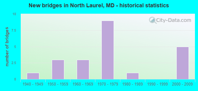
- New bridges - historical statistics
- 11940-1949
- 31950-1959
- 31960-1969
- 91970-1979
- 11980-1989
- 52000-2009

- Reconstructed bridges - Historical Statistics
- 41960-1969
- 01970-1979
- 01980-1989
- 21990-1999


- Bridge Condition - Deck
- 50.0%Good
- 16.7%Satisfactory
- 33.3%Fair

- Bridge Condition - Superstructure
- 16.7%Very good
- 25.0%Good
- 33.3%Satisfactory
- 25.0%Fair

- Bridge Condition - Substructure
- 41.7%Good
- 58.3%Satisfactory

- Bridge Condition - Channel
- 37.5%Very good
- 12.5%Good
- 12.5%Satisfactory
- 37.5%Fair

- Bridge Condition - Culverts
- 60.0%Satisfactory
- 40.0%Fair
Find on map >> Show street view
Structure Number: 100000130007011, Location: 0.38 MILE SOUTH OF MD 32 (Lat: 39.133981, Lng: -76.816197), Route carried "on" structure: US 1, Year Built: 1955, Status: Open, Structure Length: 6.58m (21.59ft), Average Daily Traffic: 19,773 (year 2012), Truck Traffic: 8%, Average Future Daily Traffic: 25,706 (year 2032), Design Load: HS 20, Features Intersected: LITTLE PATUXENT RIVER
Minimum Vertical Clearance: 30+ m (98+ ft), Kilometerpoint: 3.928, Lanes on structure: 2, Base Highway Network: Yes, Owner: State Highway Agency, Approaching Roadway Width: 10.4m (34.1ft), Material/Design: Steel continuous, Design/Construction: Stringer/Multi-beam, Number Of Spans In Main Unit: 3, Length of Maximum Span: 25.0m (82.0ft), Curb or Sidewalk Widths: Left: 0.0m, Right: 0.9m (3.0ft), Curb-To-Curb Width: 9.1m (29.9ft), Out-to-Out Width: 11.4m (37.4ft)
Condition: Deck: Good, Superstructure: Satisfactory, Substructure: Satisfactory, Channel: Very good, Operating Rating: 82.1 metric tons, Method Used To Determine Operating Rating: Load Factor (LF), Inventory Rating: 49.4 metric tons, Method Used To Determine Inventory Rating: Load Factor (LF), Structural Evaluation: Equal to present minimum criteria, Deck Geometry: Meets minimum limits, Waterway Adequacy: Superior to present desirable criteria, Approach Roadway Alignment: Equal to present desirable criteria, Length Of Structure Improvement: 6.58m (21.59ft), Designated Inspection Frequency: Every 24 months, Inspection Date: June 2020, Bridge Improvement Cost: $483,000, Roadway Improvement Cost: $48,000, Total Project Cost: $531,000, Deck Structure Type: Concrete Cast-file-Place, Wearing Surface/Protective System: Wearing Surface: Bituminous
Find on map >> Show street view
Structure Number: 100000130013011, Location: 1.05 MILES SOUTH OF MD 32 (Lat: 39.168219, Lng: -76.884258), Route carried "on" structure: US 29, Year Built: 1951, Year Reconstructed: 2001, Status: Open, Structure Length: 4.08m (13.39ft), Average Daily Traffic: 52,913 (year 2009), Truck Traffic: 8%, Average Future Daily Traffic: 31,442 (year 2026), Design Load: HS 20, Features Intersected: MIDDLE PATUXENT RIVER
Minimum Vertical Clearance: 30+ m (98+ ft), Kilometerpoint: 5.204, Lanes on structure: 2, Base Highway Network: Yes, Owner: State Highway Agency, Approaching Roadway Width: 16.2m (53.1ft), Material/Design: Steel continuous, Design/Construction: Stringer/Multi-beam, Number Of Spans In Main Unit: 3, Length of Maximum Span: 15.2m (49.9ft), Curb-To-Curb Width: 16.0m (52.5ft), Out-to-Out Width: 17.0m (55.8ft)
Condition: Deck: Satisfactory, Superstructure: Good, Substructure: Satisfactory, Channel: Very good, Operating Rating: 74.4 metric tons, Method Used To Determine Operating Rating: Load Factor (LF), Inventory Rating: 44.4 metric tons, Method Used To Determine Inventory Rating: Load Factor (LF), Structural Evaluation: Equal to present minimum criteria, Deck Geometry: Superior to present desirable criteria, Waterway Adequacy: Superior to present desirable criteria, Approach Roadway Alignment: Equal to present desirable criteria, Length Of Structure Improvement: 4.08m (13.39ft), Designated Inspection Frequency: Every 24 months, Inspection Date: October 2021, Bridge Improvement Cost: $300,000, Roadway Improvement Cost: $30,000, Total Project Cost: $330,000, Deck Structure Type: Concrete Cast-file-Place, Wearing Surface/Protective System: Wearing Surface: Bituminous
Find on map >> Show street view
Structure Number: 10000013001402, Location: 0.73 MILE NORTH OF MD 216 (Lat: 39.153683, Lng: -76.892672), Route carried "on" structure: US 29, Year Built: 1951, Year Reconstructed: 1969, Status: Open, Structure Length: 0.76m (2.49ft), Average Daily Traffic: 69,132 (year 2013), Truck Traffic: 8%, Average Future Daily Traffic: 62,885 (year 2026), Design Load: HS 20, Features Intersected: HAMMOND BRANCH
Minimum Vertical Clearance: 30+ m (98+ ft), Kilometerpoint: 3.395, Lanes on structure: 7, Base Highway Network: Yes, Owner: State Highway Agency, Approaching Roadway Width: 34.1m (111.9ft), Material/Design: Concrete, Design/Construction: Culvert, Length of Maximum Span: 3.7m (12.1ft)
Condition: Channel: Satisfactory, Culverts: Satisfactory, Operating Rating: 89.8 metric tons, Method Used To Determine Operating Rating: Load Factor (LF), Inventory Rating: 72.6 metric tons, Method Used To Determine Inventory Rating: Load Factor (LF), Structural Evaluation: Equal to present minimum criteria, Waterway Adequacy: Equal to present desirable criteria, Approach Roadway Alignment: Equal to present desirable criteria, Designated Inspection Frequency: Every 24 months, Inspection Date: March 2020
Find on map >> Show street view
Structure Number: 10000013003502, Location: 0.06 MI N OF PG CO LINE (Lat: 39.105453, Lng: -76.840417), Route carried "on" structure: US 1, Year Built: 1949, Status: Open, Structure Length: 0.79m (2.59ft), Average Daily Traffic: 16,190 (year 2013), Truck Traffic: 8%, Average Future Daily Traffic: 18,460 (year 2026), Design Load: H 20, Features Intersected: RACE TRACK RD
Minimum Vertical Clearance: 30+ m (98+ ft), Kilometerpoint: 0.084, Lanes on structure: 2, Lanes under structure: 2, Base Highway Network: Yes, Owner: State Highway Agency, Approaching Roadway Width: 13.4m (44.0ft), Skew: 2 degrees, Material/Design: Concrete, Design/Construction: Culvert, Length of Maximum Span: 7.6m (24.9ft)
Condition: Culverts: Fair, Structural Evaluation: Somewhat better than minimum adequacy, Underclear: High priority of corrective action, Approach Roadway Alignment: Equal to present desirable criteria, Designated Inspection Frequency: Every 24 months, Inspection Date: August 2021
Find on map >> Show street view
Structure Number: 10000013007401, Location: 0.96 MI N OF MD 216 (Lat: 39.138508, Lng: -76.849461), Route carried "on" structure: County highway 416, Year Built: 1970, Year Reconstructed: 1972, Status: Open, Structure Length: 12.34m (40.49ft), Average Daily Traffic: 8,371 (year 2009), Truck Traffic: 5%, Average Future Daily Traffic: 5,619 (year 2026), Design Load: HS 20, Features Intersected: IS 95, Facility Carried by Structure: GORMAN ROAD
Minimum Vertical Clearance: 30+ m (98+ ft), Kilometerpoint: 2.944, Lanes on structure: 2, Lanes under structure: 9, Owner: State Highway Agency, Approaching Roadway Width: 7.3m (24.0ft), Material/Design: Steel continuous, Design/Construction: Stringer/Multi-beam, Number Of Spans In Main Unit: 4, Length of Maximum Span: 40.8m (133.9ft), Curb or Sidewalk Widths: Left: 0.0m, Right: 1.5m (4.9ft), Curb-To-Curb Width: 13.4m (44.0ft), Out-to-Out Width: 16.2m (53.1ft)
Condition: Deck: Satisfactory, Superstructure: Satisfactory, Substructure: Satisfactory, Inventory Rating: 65.3 metric tons, Method Used To Determine Inventory Rating: Load Factor (LF), Structural Evaluation: Equal to present minimum criteria, Deck Geometry: Equal to present minimum criteria, Underclear: Somewhat better than minimum adequacy, Approach Roadway Alignment: Equal to present desirable criteria, Designated Inspection Frequency: Every 24 months, Inspection Date: January 2022, Deck Structure Type: Concrete Cast-file-Place, Wearing Surface/Protective System: Wearing Surface: Monolithic Concrete
Find on map >> Show street view
Structure Number: 10000013007502, Location: 0.38 MILE NORTH OD MD 216 (Lat: 39.133003, Lng: -76.857133), Route carried "on" structure: Interstate 95, Year Built: 1968, Status: Open, Structure Length: 0.99m (3.25ft), Average Daily Traffic: 192,401 (year 2013), Truck Traffic: 8%, Average Future Daily Traffic: 204,260 (year 2026), Design Load: HS 20, Features Intersected: HAMMOND BRANCH
Minimum Vertical Clearance: 30+ m (98+ ft), Kilometerpoint: 2.478, Lanes on structure: 10, Base Highway Network: Yes, Owner: State Highway Agency, Approaching Roadway Width: 41.5m (136.2ft), Material/Design: Concrete, Design/Construction: Culvert, Length of Maximum Span: 3.0m (9.8ft)
Condition: Channel: Fair, Culverts: Satisfactory, Structural Evaluation: Equal to present minimum criteria, Waterway Adequacy: Equal to present desirable criteria, Approach Roadway Alignment: Equal to present desirable criteria, Designated Inspection Frequency: Every 24 months, Inspection Date: June 2020
Find on map >> Show street view
Structure Number: 100000130076013, Location: 1.56 MILES N OF PG CO (Lat: 39.129067, Lng: -76.861800), Route carried "on" structure: State highway 216, Year Built: 1970, Year Reconstructed: 1972, Status: Open, Structure Length: 12.71m (41.70ft), Average Daily Traffic: 20,412 (year 2009), Truck Traffic: 8%, Average Future Daily Traffic: 9,392 (year 2026), Design Load: HS 20, Features Intersected: IS 95
Minimum Vertical Clearance: 30+ m (98+ ft), Kilometerpoint: 2.454, Lanes on structure: 3, Lanes under structure: 10, Owner: State Highway Agency, Approaching Roadway Width: 13.4m (44.0ft), Skew: 1 degrees, Material/Design: Steel continuous, Design/Construction: Stringer/Multi-beam, Number Of Spans In Main Unit: 4, Length of Maximum Span: 41.1m (134.8ft), Curb-To-Curb Width: 14.3m (46.9ft), Out-to-Out Width: 15.2m (49.9ft)
Condition: Deck: Fair, Superstructure: Satisfactory, Substructure: Good, Operating Rating: 55.3 metric tons, Method Used To Determine Operating Rating: Load Factor (LF), Inventory Rating: 33.1 metric tons, Method Used To Determine Inventory Rating: Load Factor (LF), Structural Evaluation: Equal to present minimum criteria, Deck Geometry: Somewhat better than minimum adequacy, Underclear: Somewhat better than minimum adequacy, Approach Roadway Alignment: Equal to present desirable criteria, Designated Inspection Frequency: Every 24 months, Inspection Date: Febuary 2020, Deck Structure Type: Concrete Cast-file-Place, Wearing Surface/Protective System: Wearing Surface: Monolithic Concrete
Find on map >> Show street view
Structure Number: 100000130076014, Location: 1.56 MILES N OF PG CO (Lat: 39.129764, Lng: -76.862864), Route carried "on" structure: State highway 216, Year Built: 1970, Year Reconstructed: 1972, Status: Open, Structure Length: 12.71m (41.70ft), Average Daily Traffic: 20,412 (year 2009), Truck Traffic: 8%, Average Future Daily Traffic: 9,392 (year 2026), Design Load: HS 20, Features Intersected: IS 95
Minimum Vertical Clearance: 30+ m (98+ ft), Kilometerpoint: 2.454, Lanes on structure: 3, Lanes under structure: 10, Owner: State Highway Agency, Approaching Roadway Width: 13.4m (44.0ft), Skew: 1 degrees, Material/Design: Steel continuous, Design/Construction: Stringer/Multi-beam, Number Of Spans In Main Unit: 4, Length of Maximum Span: 41.1m (134.8ft), Curb-To-Curb Width: 14.3m (46.9ft), Out-to-Out Width: 15.2m (49.9ft)
Condition: Deck: Fair, Superstructure: Satisfactory, Substructure: Satisfactory, Operating Rating: 55.3 metric tons, Method Used To Determine Operating Rating: Load Factor (LF), Inventory Rating: 33.1 metric tons, Method Used To Determine Inventory Rating: Load Factor (LF), Structural Evaluation: Equal to present minimum criteria, Deck Geometry: Somewhat better than minimum adequacy, Underclear: Somewhat better than minimum adequacy, Approach Roadway Alignment: Equal to present desirable criteria, Designated Inspection Frequency: Every 24 months, Inspection Date: Febuary 2020, Deck Structure Type: Concrete Cast-file-Place, Wearing Surface/Protective System: Wearing Surface: Monolithic Concrete
Find on map >> Show street view
Structure Number: 100000130077011, Location: 0.50 MI N OF PG CO (Lat: 39.120667, Lng: -76.867442), Route carried "on" structure: Interstate 95, Year Built: 1970, Status: Open, Structure Length: 3.72m (12.20ft), Average Daily Traffic: 186,040 (year 2009), Truck Traffic: 8%, Average Future Daily Traffic: 290,600 (year 2029), Design Load: HS 20, Features Intersected: STANSFIELD RD
Minimum Vertical Clearance: 30+ m (98+ ft), Kilometerpoint: 0.787, Lanes on structure: 4, Lanes under structure: 2, Base Highway Network: Yes, Owner: State Highway Agency, Approaching Roadway Width: 20.7m (67.9ft), Skew: 1 degrees, Material/Design: Concrete continuous, Design/Construction: Slab, Number Of Spans In Main Unit: 3, Length of Maximum Span: 15.9m (52.2ft), Curb-To-Curb Width: 20.7m (67.9ft), Out-to-Out Width: 21.6m (70.9ft)
Condition: Deck: Fair, Superstructure: Fair, Substructure: Satisfactory, Inventory Rating: 67.6 metric tons, Method Used To Determine Inventory Rating: Load Factor (LF), Structural Evaluation: Somewhat better than minimum adequacy, Deck Geometry: Equal to present minimum criteria, Underclear: Better than present minimum criteria, Approach Roadway Alignment: Equal to present desirable criteria, Length Of Structure Improvement: 3.72m (12.20ft), Designated Inspection Frequency: Every 24 months, Inspection Date: March 2020, Bridge Improvement Cost: $520,000, Roadway Improvement Cost: $52,000, Total Project Cost: $572,000, Deck Structure Type: Concrete Cast-file-Place, Wearing Surface/Protective System: Wearing Surface: Latex Concrete, Deck Protection: Cathodic Protection
Find on map >> Show street view
Structure Number: 100000130077012, Location: 0.50 MI N OF PG CO (Lat: 39.121161, Lng: -76.868122), Route carried "on" structure: Interstate 95, Year Built: 1970, Status: Open, Structure Length: 3.66m (12.01ft), Average Daily Traffic: 186,040 (year 2009), Truck Traffic: 8%, Average Future Daily Traffic: 290,600 (year 2029), Design Load: HS 20, Features Intersected: STANSFIELD RD
Minimum Vertical Clearance: 30+ m (98+ ft), Kilometerpoint: 0.787, Lanes on structure: 4, Lanes under structure: 2, Base Highway Network: Yes, Owner: State Highway Agency, Approaching Roadway Width: 20.7m (67.9ft), Material/Design: Concrete continuous, Design/Construction: Slab, Number Of Spans In Main Unit: 3, Length of Maximum Span: 16.5m (54.1ft), Curb-To-Curb Width: 20.7m (67.9ft), Out-to-Out Width: 21.6m (70.9ft)
Condition: Deck: Fair, Superstructure: Fair, Substructure: Satisfactory, Operating Rating: 76.2 metric tons, Method Used To Determine Operating Rating: Load Factor (LF), Inventory Rating: 45.4 metric tons, Method Used To Determine Inventory Rating: Load Factor (LF), Structural Evaluation: Somewhat better than minimum adequacy, Deck Geometry: Equal to present minimum criteria, Underclear: Meets minimum limits, Approach Roadway Alignment: Equal to present desirable criteria, Length Of Structure Improvement: 3.66m (12.01ft), Designated Inspection Frequency: Every 24 months, Inspection Date: March 2020, Bridge Improvement Cost: $511,000, Roadway Improvement Cost: $51,000, Total Project Cost: $562,000, Deck Structure Type: Concrete Cast-file-Place, Wearing Surface/Protective System: Wearing Surface: Latex Concrete, Deck Protection: Cathodic Protection
Find on map >> Show street view
Structure Number: 100000130152013, Location: .16 M N OF ICE CRYSTAL DR (Lat: 39.145169, Lng: -76.900397), Route carried "on" structure: State highway 216, Year Built: 2001, Status: Open, Structure Length: 8.99m (29.49ft), Average Daily Traffic: 17,672 (year 2009), Truck Traffic: 4%, Average Future Daily Traffic: 6,994 (year 2026), Design Load: HS 25 or greater, Features Intersected: US 29
Minimum Vertical Clearance: 30+ m (98+ ft), Kilometerpoint: 6.505, Lanes on structure: 2, Lanes under structure: 8, Owner: State Highway Agency, Approaching Roadway Width: 29.3m (96.1ft), Skew: 3 degrees, Material/Design: Steel continuous, Design/Construction: Stringer/Multi-beam, Number Of Spans In Main Unit: 2, Length of Maximum Span: 44.2m (145.0ft), Curb or Sidewalk Widths: Left: 0.0m, Right: 1.6m (5.2ft), Curb-To-Curb Width: 9.1m (29.9ft), Out-to-Out Width: 117.3m (384.8ft)
Condition: Deck: Good, Superstructure: Very good, Substructure: Good, Operating Rating: 56.7 metric tons, Method Used To Determine Operating Rating: Load Factor (LF), Inventory Rating: 34.0 metric tons, Method Used To Determine Inventory Rating: Load Factor (LF), Structural Evaluation: Better than present minimum criteria, Deck Geometry: Meets minimum limits, Underclear: Equal to present minimum criteria, Approach Roadway Alignment: Equal to present desirable criteria, Designated Inspection Frequency: Every 24 months, Inspection Date: May 2021, Deck Structure Type: Concrete Cast-file-Place, Wearing Surface/Protective System: Wearing Surface: Monolithic Concrete, Deck Protection: Epoxy Coated Reinforcing
Find on map >> Show street view
Structure Number: 10000013015401, Location: OVER US 29 (Lat: 39.158939, Lng: -76.888258), Route carried "on" structure: County highway 109, Year Built: 2001, Status: Open, Structure Length: 8.02m (26.31ft), Average Daily Traffic: 7,207 (year 2006), Average Future Daily Traffic: 8,310 (year 2026), Design Load: HS 25 or greater, Features Intersected: US 29, Facility Carried by Structure: HOPKINS/GORMAN RD
Minimum Vertical Clearance: 30+ m (98+ ft), Kilometerpoint: 0.790, Lanes on structure: 6, Lanes under structure: 7, Owner: State Highway Agency, Approaching Roadway Width: 25.6m (84.0ft), Skew: 21 degrees, Material/Design: Steel continuous, Design/Construction: Stringer/Multi-beam, Number Of Spans In Main Unit: 2, Length of Maximum Span: 41.5m (136.2ft), Curb or Sidewalk Widths: Left: 1.6m (5.2ft), Right: 1.6m (5.2ft), Curb-To-Curb Width: 24.4m (80.1ft), Out-to-Out Width: 29.6m (97.1ft)
Condition: Deck: Good, Superstructure: Good, Substructure: Good, Operating Rating: 68.5 metric tons, Method Used To Determine Operating Rating: Load Factor (LF), Inventory Rating: 40.8 metric tons, Method Used To Determine Inventory Rating: Load Factor (LF), Structural Evaluation: Better than present minimum criteria, Deck Geometry: Somewhat better than minimum adequacy, Underclear: Equal to present minimum criteria, Approach Roadway Alignment: Equal to present desirable criteria, Designated Inspection Frequency: Every 24 months, Inspection Date: July 2021, Deck Structure Type: Concrete Cast-file-Place, Wearing Surface/Protective System: Wearing Surface: Monolithic Concrete, Deck Protection: Epoxy Coated Reinforcing
Find on map >> Show street view
Structure Number: 10000013015601, Location: .78 MI S OF I-95 (Lat: 39.120497, Lng: -76.853292), Route carried "on" structure: Ramp State highway 216, Year Built: 2003, Status: Open, Structure Length: 5.27m (17.29ft), Average Daily Traffic: 3,691 (year 2010), Average Future Daily Traffic: 5,315 (year 2032), Design Load: HS 25 or greater, Features Intersected: MD 216
Minimum Vertical Clearance: 30+ m (98+ ft), Kilometerpoint: 0.208, Lanes on structure: 1, Lanes under structure: 5, Owner: State Highway Agency, Approaching Roadway Width: 7.3m (24.0ft), Material/Design: Steel continuous, Design/Construction: Stringer/Multi-beam, Number Of Spans In Main Unit: 2, Length of Maximum Span: 26.8m (87.9ft), Curb-To-Curb Width: 7.3m (24.0ft), Out-to-Out Width: 8.5m (27.9ft)
Condition: Deck: Good, Superstructure: Very good, Substructure: Good, Operating Rating: 40.8 metric tons, Method Used To Determine Operating Rating: Field evaluation and documented engineering judgment, Inventory Rating: 40.8 metric tons, Method Used To Determine Inventory Rating: Field evaluation and documented engineering judgment, Structural Evaluation: Better than present minimum criteria, Deck Geometry: Better than present minimum criteria, Underclear: Equal to present minimum criteria, Approach Roadway Alignment: Equal to present minimum criteria, Designated Inspection Frequency: Every 24 months, Inspection Date: September 2020, Deck Structure Type: Concrete Cast-file-Place, Wearing Surface/Protective System: Wearing Surface: Monolithic Concrete, Deck Protection: Epoxy Coated Reinforcing
Find on map >> Show street view
Structure Number: 100000160197012, Location: ON HOWARD CO LINE (Lat: 39.115933, Lng: -76.872892), Route carried "on" structure: Interstate 95, Year Built: 1971, Status: Open, Structure Length: 15.70m (51.51ft), Average Daily Traffic: 186,040 (year 2009), Truck Traffic: 8%, Average Future Daily Traffic: 96,730 (year 2026), Design Load: HS 20, Features Intersected: PATUXENT RIVER
Minimum Vertical Clearance: 30+ m (98+ ft), Kilometerpoint: 54.794, Lanes on structure: 4, Base Highway Network: Yes, Owner: State Highway Agency, Approaching Roadway Width: 20.7m (67.9ft), Material/Design: Steel continuous, Design/Construction: Stringer/Multi-beam, Number Of Spans In Main Unit: 3, Length of Maximum Span: 54.9m (180.1ft), Curb-To-Curb Width: 20.7m (67.9ft), Out-to-Out Width: 21.6m (70.9ft)
Condition: Deck: Good, Superstructure: Fair, Substructure: Satisfactory, Channel: Very good, Operating Rating: 54.4 metric tons, Method Used To Determine Operating Rating: Load Factor (LF), Inventory Rating: 32.7 metric tons, Method Used To Determine Inventory Rating: Load Factor (LF), Structural Evaluation: Somewhat better than minimum adequacy, Deck Geometry: Equal to present minimum criteria, Waterway Adequacy: Equal to present desirable criteria, Approach Roadway Alignment: Equal to present desirable criteria, Length Of Structure Improvement: 15.70m (51.51ft), Designated Inspection Frequency: Every 12 months, Inspection Date: July 2021, Bridge Improvement Cost: $2,194,000, Roadway Improvement Cost: $219,000, Total Project Cost: $2,413,000, Deck Structure Type: Concrete Cast-file-Place, Wearing Surface/Protective System: Wearing Surface: Monolithic Concrete
Find on map >> Show street view
Structure Number: 200000HO001401, Location: 0.1 MI S VOLLMERHAUSEN RD (Lat: 39.160147, Lng: -76.851967), Route carried "on" structure: County highway 115, Year Built: 1988, Status: Open, Structure Length: 4.08m (13.39ft), Average Daily Traffic: 3,576 (year 2002), Truck Traffic: 4%, Average Future Daily Traffic: 12,500 (year 2010), Design Load: HS 20, Features Intersected: MIDDLE PATUXENT RIVER, Facility Carried by Structure: MURRAY HILL ROAD
Minimum Vertical Clearance: 30+ m (98+ ft), Kilometerpoint: 1.014, Lanes on structure: 2, Owner: County Highway Agency, Approaching Roadway Width: 7.9m (25.9ft), Material/Design: Steel continuous, Design/Construction: Stringer/Multi-beam, Number Of Spans In Main Unit: 2, Length of Maximum Span: 19.8m (65.0ft), Curb-To-Curb Width: 11.0m (36.1ft), Out-to-Out Width: 11.9m (39.0ft)
Condition: Deck: Good, Superstructure: Good, Substructure: Good, Channel: Fair, Operating Rating: 71.2 metric tons, Method Used To Determine Operating Rating: Load Factor (LF), Inventory Rating: 42.6 metric tons, Method Used To Determine Inventory Rating: Load Factor (LF), Structural Evaluation: Better than present minimum criteria, Deck Geometry: Somewhat better than minimum adequacy, Waterway Adequacy: Better than present minimum criteria, Approach Roadway Alignment: Equal to present desirable criteria, Designated Inspection Frequency: Every 24 months, Inspection Date: March 2020, Deck Structure Type: Concrete Cast-file-Place, Wearing Surface/Protective System: Wearing Surface: Integral Concrete, Deck Protection: Epoxy Coated Reinforcing
Find on map >> Show street view
Structure Number: 200000HO005802, Location: 0.2 MI N OF MD RTE 216 (Lat: 39.141425, Lng: -76.876525), Route carried "on" structure: County highway 91, Year Built: 1969, Year Reconstructed: 2002, Status: Open, Structure Length: 0.82m (2.69ft), Average Daily Traffic: 7,344 (year 2000), Truck Traffic: 4%, Average Future Daily Traffic: 13,400 (year 2015), Design Load: HS 20, Features Intersected: HAMMOND BRANCH, Facility Carried by Structure: LEISHEAR ROAD
Minimum Vertical Clearance: 30+ m (98+ ft), Kilometerpoint: 0.595, Lanes on structure: 2, Owner: County Highway Agency, Approaching Roadway Width: 10.4m (34.1ft), Material/Design: Concrete, Design/Construction: Culvert, Length of Maximum Span: 3.7m (12.1ft)
Condition: Channel: Good, Culverts: Satisfactory, Operating Rating: 69.4 metric tons, Method Used To Determine Operating Rating: Load Factor (LF), Inventory Rating: 41.3 metric tons, Method Used To Determine Inventory Rating: Load Factor (LF), Structural Evaluation: Equal to present minimum criteria, Waterway Adequacy: Better than present minimum criteria, Approach Roadway Alignment: Equal to present desirable criteria, Designated Inspection Frequency: Every 24 months, Inspection Date: March 2020, Deck Structure Type: Concrete Cast-file-Place
Find on map >> Show street view
Structure Number: 200000HO028003, Location: 1/8 M WEST OF US 1 (Lat: 39.108814, Lng: -76.840861), Route carried "on" structure: County highway , Year Built: 1965, Status: Open, Structure Length: 0.67m (2.20ft), Average Daily Traffic: 400 (year 2016), Truck Traffic: 2%, Average Future Daily Traffic: 400 (year 2037), Features Intersected: UNNAMED STREAM, Facility Carried by Structure: N. LAUREL ROAD
Minimum Vertical Clearance: 30+ m (98+ ft), Kilometerpoint: 0.000, Lanes on structure: 2, Owner: County Highway Agency, Approaching Roadway Width: 13.1m (43.0ft), Material/Design: Steel, Design/Construction: Culvert, Length of Maximum Span: 1.5m (4.9ft)
Condition: Channel: Fair, Culverts: Fair, Structural Evaluation: Somewhat better than minimum adequacy, Waterway Adequacy: Equal to present desirable criteria, Approach Roadway Alignment: Equal to present minimum criteria, Designated Inspection Frequency: Every 24 months, Inspection Date: Febuary 2020
Find on map >> Show street view
Structure Number: 10000013007401, Location: 0.96 MILE NORTH OF MD 216 (Lat: 39.138508, Lng: -76.849461), Route carried "under" structure: Interstate 95, Year Built: 1970, Structure Length: 0. m, Average Daily Traffic: 186,750 (year 2009), Features Intersected: IS 95, Facility Carried by Structure: GORMAN ROAD
Minimum Vertical Clearance: 4.88m (16.01ft), Kilometerpoint: 3.411, Lanes on structure: 2, Lanes under structure: 9, Material/Design: Steel continuous, Design/Construction: Stringer/Multi-beam, Length of Maximum Span: 40.8m (133.9ft)
Find on map >> Show street view
Structure Number: 100000130076013, Location: 1.16 MILES N OF PG CO (Lat: 39.129067, Lng: -76.861800), Route carried "under" structure: Interstate 95, Year Built: 1970, Structure Length: 0. m, Average Daily Traffic: 186,750 (year 2009), Features Intersected: IS 95, Facility Carried by Structure: MD 216 EBR
Minimum Vertical Clearance: 4.88m (16.01ft), Kilometerpoint: 1.866, Lanes on structure: 3, Lanes under structure: 10, Material/Design: Steel continuous, Design/Construction: Stringer/Multi-beam, Length of Maximum Span: 46.0m (150.9ft)
Find on map >> Show street view
Structure Number: 100000130076014, Location: 1.16 MILES N OF PG CO (Lat: 39.129764, Lng: -76.862864), Route carried "under" structure: Interstate 95, Year Built: 1970, Structure Length: 0. m, Average Daily Traffic: 186,750 (year 2009), Features Intersected: IS 95, Facility Carried by Structure: MD 216 WBR
Minimum Vertical Clearance: 4.88m (16.01ft), Kilometerpoint: 1.866, Lanes on structure: 3, Lanes under structure: 10, Material/Design: Steel continuous, Design/Construction: Stringer/Multi-beam, Length of Maximum Span: 46.0m (150.9ft)
Find on map >> Show street view
Structure Number: 100000130152013, Location: 1.38 M N OF MONT CO LINE (Lat: 39.145169, Lng: -76.900397), Route carried "under" structure: US 29, Year Built: 2001, Structure Length: 0. m, Average Daily Traffic: 62,080 (year 2009), Truck Traffic: 8%, Features Intersected: US 29, Facility Carried by Structure: MD 216 EBR
Minimum Vertical Clearance: 5.49m (18.01ft), Kilometerpoint: 2.220, Lanes on structure: 2, Lanes under structure: 8, Material/Design: Steel continuous, Design/Construction: Stringer/Multi-beam, Length of Maximum Span: 44.2m (145.0ft)
Find on map >> Show street view
Structure Number: 10000013015401, Location: 0.41 M N OF BR NO 1301400 (Lat: 39.158939, Lng: -76.888258), Route carried "under" structure: US 29, Year Built: 2000, Structure Length: 0. m, Average Daily Traffic: 52,913 (year 2009), Truck Traffic: 7%, Features Intersected: US 29, Facility Carried by Structure: HOPKINS/GORMAN RD
Minimum Vertical Clearance: 5.79m (19.00ft), Kilometerpoint: 4.055, Lanes on structure: 6, Lanes under structure: 7, Material/Design: Steel continuous, Design/Construction: Stringer/Multi-beam, Length of Maximum Span: 41.5m (136.2ft)