Bridge Statistics for North Kansas City, Missouri (MO)
Condition, Traffic, Stress, Structural Evaluation, Project Costs
- National Bridge Inventory (NBI) Statistics
- 20Number of bridges
- 243ft / 73.5mTotal length
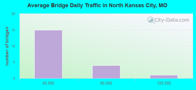
- 436,874Total average daily traffic
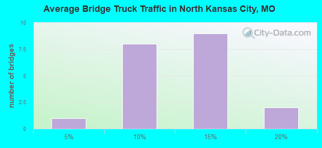
- 46,977Total average daily truck traffic
- National Bridge Inventory (NBI) Registered Bridges for North Kansas City
- No street view available for this location
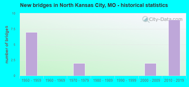
- New bridges - historical statistics
- 71950-1959
- 21970-1979
- 22000-2009
- 92010-2019
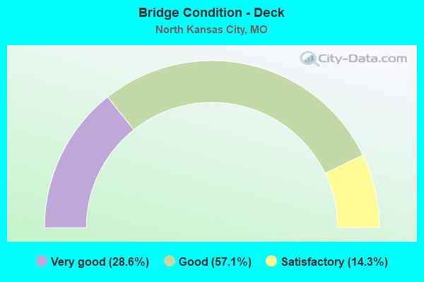
- Bridge Condition - Deck
- 28.6%Very good
- 57.1%Good
- 14.3%Satisfactory
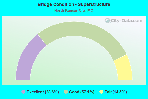
- Bridge Condition - Superstructure
- 28.6%Excellent
- 57.1%Good
- 14.3%Fair
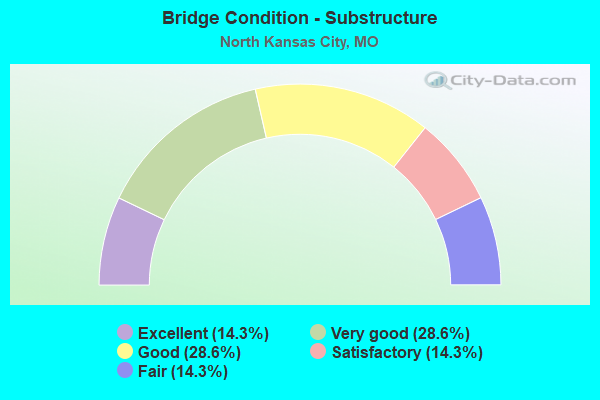
- Bridge Condition - Substructure
- 14.3%Excellent
- 28.6%Very good
- 28.6%Good
- 14.3%Satisfactory
- 14.3%Fair
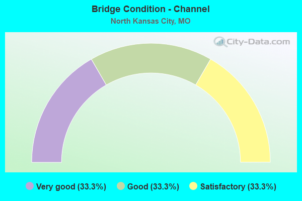
- Bridge Condition - Channel
- 33.3%Very good
- 33.3%Good
- 33.3%Satisfactory
Find on map >> Show street view
Structure Number: 21542, Location: S 15 T 50 N R 33 W (Lat: 39.148728, Lng: -94.547739), Route carried "on" structure: City street , Year Built: 1975, Status: Open, Structure Length: 1.16m (3.81ft), Average Daily Traffic: 3,000 (year 2020), Truck Traffic: 10%, Average Future Daily Traffic: 4,800 (year 2040), Features Intersected: ROCK CR, Facility Carried by Structure: ROCK CREEK PKWY
Minimum Vertical Clearance: 30+ m (98+ ft), Kilometerpoint: 0.161, Lanes on structure: 4, Owner: City or Municipal Highway Agency, Approaching Roadway Width: 17.4m (57.1ft), Material/Design: Concrete, Design/Construction: Culvert, Number Of Spans In Main Unit: 3, Length of Maximum Span: 3.7m (12.1ft)
Condition: Channel: Satisfactory, Culverts: Satisfactory, Operating Rating: 49.5 metric tons, Method Used To Determine Operating Rating: Allowable Stress (AS), Inventory Rating: 16.2 metric tons, Method Used To Determine Inventory Rating: Allowable Stress (AS), Structural Evaluation: Meets minimum limits, Waterway Adequacy: Better than present minimum criteria, Approach Roadway Alignment: Equal to present desirable criteria, Designated Inspection Frequency: Every 24 months, Inspection Date: December 2021
Find on map >> Show street view
Structure Number: 21543, Location: S 15 T 50 N R 33 W (Lat: 39.149650, Lng: -94.564558), Route carried "on" structure: City street 311, Year Built: 1970, Status: Open, Structure Length: 0.76m (2.49ft), Average Daily Traffic: 350 (year 2020), Truck Traffic: 10%, Average Future Daily Traffic: 560 (year 2040), Features Intersected: ROCK CR, Facility Carried by Structure: OZARK EXT
Minimum Vertical Clearance: 30+ m (98+ ft), Kilometerpoint: 0.322, Lanes on structure: 2, Owner: City or Municipal Highway Agency, Approaching Roadway Width: 7.3m (24.0ft), Material/Design: Concrete, Design/Construction: Culvert, Number Of Spans In Main Unit: 2, Length of Maximum Span: 3.7m (12.1ft)
Condition: Channel: Good, Culverts: Satisfactory, Operating Rating: 49.5 metric tons, Method Used To Determine Operating Rating: Allowable Stress (AS), Inventory Rating: 16.2 metric tons, Method Used To Determine Inventory Rating: Allowable Stress (AS), Structural Evaluation: Somewhat better than minimum adequacy, Waterway Adequacy: Better than present minimum criteria, Approach Roadway Alignment: Equal to present desirable criteria, Designated Inspection Frequency: Every 24 months, Inspection Date: December 2021
Find on map >> Show street view
Structure Number: 32838, Location: S 13 T 50 N R 33 W (Lat: 39.137711, Lng: -94.567428), Route carried "on" structure: Interstate 29, Year Built: 2009, Status: Open, Structure Length: 2.90m (9.51ft), Average Daily Traffic: 53,599 (year 2021), Truck Traffic: 12%, Average Future Daily Traffic: 96,478 (year 2041), Design Load: HS 20+Mod, Features Intersected: CST 16TH AVE
Minimum Vertical Clearance: 30+ m (98+ ft), Kilometerpoint: 3.901, Lanes on structure: 3, Lanes under structure: 3, Base Highway Network: Yes, Owner: State Highway Agency, Approaching Roadway Width: 17.1m (56.1ft), Skew: 1 degrees, Material/Design: Prestressed concrete, Design/Construction: Tee Beam, Number Of Spans In Main Unit: 1, Length of Maximum Span: 27.7m (90.9ft), Curb-To-Curb Width: 17.1m (56.1ft), Out-to-Out Width: 17.9m (58.7ft)
Condition: Deck: Very good, Superstructure: Excellent, Substructure: Good, Operating Rating: 74.7 metric tons, Method Used To Determine Operating Rating: Load Factor (LF), Inventory Rating: 41.4 metric tons, Method Used To Determine Inventory Rating: Load Factor (LF), Structural Evaluation: Better than present minimum criteria, Deck Geometry: Equal to present minimum criteria, Approach Roadway Alignment: Equal to present desirable criteria, Designated Inspection Frequency: Every 24 months, Inspection Date: September 2020, Deck Structure Type: Concrete Cast-file-Place, Wearing Surface/Protective System: Wearing Surface: Monolithic Concrete, Deck Protection: Epoxy Coated Reinforcing
Find on map >> Show street view
Structure Number: 32846, Location: S 13 T 50 N R 33 W (Lat: 39.137703, Lng: -94.567639), Route carried "on" structure: Interstate 29, Year Built: 2010, Status: Open, Structure Length: 2.88m (9.45ft), Average Daily Traffic: 52,000 (year 2021), Truck Traffic: 10%, Average Future Daily Traffic: 93,600 (year 2041), Design Load: HS 20+Mod, Features Intersected: CST 16TH AVE
Minimum Vertical Clearance: 30+ m (98+ ft), Kilometerpoint: 203.246, Lanes on structure: 3, Lanes under structure: 3, Base Highway Network: Yes, Owner: State Highway Agency, Approaching Roadway Width: 17.1m (56.1ft), Material/Design: Prestressed concrete, Design/Construction: Tee Beam, Number Of Spans In Main Unit: 1, Length of Maximum Span: 27.7m (90.9ft), Curb-To-Curb Width: 17.1m (56.1ft), Out-to-Out Width: 17.9m (58.7ft)
Condition: Deck: Good, Superstructure: Excellent, Substructure: Excellent, Operating Rating: 75.6 metric tons, Method Used To Determine Operating Rating: Load Factor (LF), Inventory Rating: 43.2 metric tons, Method Used To Determine Inventory Rating: Load Factor (LF), Structural Evaluation: Superior to present desirable criteria, Deck Geometry: Equal to present minimum criteria, Underclear: Superior to present desirable criteria, Approach Roadway Alignment: Equal to present desirable criteria, Designated Inspection Frequency: Every 24 months, Inspection Date: September 2020, Deck Structure Type: Concrete Cast-file-Place, Wearing Surface/Protective System: Wearing Surface: Monolithic Concrete, Deck Protection: Epoxy Coated Reinforcing
Find on map >> Show street view
Structure Number: 32873, Location: S 13 T 50 N R 33 W (Lat: 39.144686, Lng: -94.561914), Route carried "on" structure: Interstate 29, Year Built: 2010, Status: Open, Structure Length: 7.45m (24.44ft), Average Daily Traffic: 43,665 (year 2021), Truck Traffic: 12%, Average Future Daily Traffic: 78,597 (year 2041), Design Load: HS 20+Mod, Features Intersected: RP MO210W TO IS29S, RP M
Minimum Vertical Clearance: 30+ m (98+ ft), Kilometerpoint: 202.305, Lanes on structure: 4, Lanes under structure: 8, Base Highway Network: Yes, Owner: State Highway Agency, Approaching Roadway Width: 19.5m (64.0ft), Skew: 4 degrees, Material/Design: Prestressed concrete continuous, Design/Construction: Tee Beam, Number Of Spans In Main Unit: 4, Length of Maximum Span: 21.3m (69.9ft), Curb-To-Curb Width: 19.5m (64.0ft), Out-to-Out Width: 20.4m (66.9ft)
Condition: Deck: Good, Superstructure: Good, Substructure: Good, Operating Rating: 91.8 metric tons, Method Used To Determine Operating Rating: Load Factor (LF), Inventory Rating: 54.9 metric tons, Method Used To Determine Inventory Rating: Load Factor (LF), Structural Evaluation: Better than present minimum criteria, Deck Geometry: Somewhat better than minimum adequacy, Underclear: High priority of corrective action, Approach Roadway Alignment: Equal to present desirable criteria, Designated Inspection Frequency: Every 24 months, Inspection Date: September 2020, Deck Structure Type: Concrete Cast-file-Place, Wearing Surface/Protective System: Wearing Surface: Monolithic Concrete, Deck Protection: Epoxy Coated Reinforcing
Find on map >> Show street view
Structure Number: 34621, Location: S 11 T 50 N R 32 W (Lat: 39.154797, Lng: -94.471181), Route carried "on" structure: State highway 210, Year Built: 2014, Status: Open, Structure Length: 6.74m (22.11ft), Average Daily Traffic: 8,405 (year 2021), Truck Traffic: 5%, Average Future Daily Traffic: 15,129 (year 2041), Features Intersected: DM&E RR
Minimum Vertical Clearance: 30+ m (98+ ft), Kilometerpoint: 8.570, Lanes on structure: 2, Base Highway Network: Yes, Owner: State Highway Agency, Approaching Roadway Width: 11.6m (38.1ft), Skew: 4 degrees, Material/Design: Prestressed concrete continuous, Design/Construction: Stringer/Multi-beam, Number Of Spans In Main Unit: 3, Length of Maximum Span: 26.2m (86.0ft), Curb-To-Curb Width: 11.6m (38.1ft), Out-to-Out Width: 12.4m (40.7ft)
Condition: Deck: Good, Superstructure: Good, Substructure: Very good, Operating Rating: 93.6 metric tons, Method Used To Determine Operating Rating: Load Factor (LF), Inventory Rating: 49.5 metric tons, Method Used To Determine Inventory Rating: Load Factor (LF), Structural Evaluation: Better than present minimum criteria, Deck Geometry: Equal to present minimum criteria, Underclear: Equal to present desirable criteria, Approach Roadway Alignment: Equal to present desirable criteria, Designated Inspection Frequency: Every 24 months, Inspection Date: September 2020, Deck Structure Type: Concrete Cast-file-Place, Wearing Surface/Protective System: Wearing Surface: Monolithic Concrete, Deck Protection: Epoxy Coated Reinforcing
Find on map >> Show street view
Structure Number: 34783, Location: S 13 T 50 N R 33 W (Lat: 39.147364, Lng: -94.556072), Route carried "on" structure: State highway 1, Year Built: 2014, Status: Open, Structure Length: 1.58m (5.18ft), Average Daily Traffic: 6,842 (year 2021), Truck Traffic: 2%, Average Future Daily Traffic: 10,947 (year 2041), Features Intersected: DRAIN DTCH
Minimum Vertical Clearance: 30+ m (98+ ft), Kilometerpoint: 11.525, Lanes on structure: 3, Owner: State Highway Agency, Approaching Roadway Width: 13.4m (44.0ft), Material/Design: Prestressed concrete, Design/Construction: Stringer/Multi-beam, Number Of Spans In Main Unit: 1, Length of Maximum Span: 15.2m (49.9ft), Curb or Sidewalk Widths: Left: 0.0m, Right: 3.0m (9.8ft), Curb-To-Curb Width: 14.8m (48.6ft), Out-to-Out Width: 18.7m (61.4ft)
Condition: Deck: Very good, Superstructure: Good, Substructure: Very good, Channel: Very good, Operating Rating: 90.0 metric tons, Method Used To Determine Operating Rating: Load Factor (LF), Inventory Rating: 54.0 metric tons, Method Used To Determine Inventory Rating: Load Factor (LF), Structural Evaluation: Better than present minimum criteria, Deck Geometry: Equal to present minimum criteria, Waterway Adequacy: Superior to present desirable criteria, Approach Roadway Alignment: Equal to present desirable criteria, Designated Inspection Frequency: Every 24 months, Inspection Date: September 2020, Deck Structure Type: Concrete Cast-file-Place, Wearing Surface/Protective System: Wearing Surface: Monolithic Concrete, Deck Protection: Epoxy Coated Reinforcing
Find on map >> Show street view
Structure Number: 6678, Location: S 24 T 50 N R 33 W (Lat: 39.132531, Lng: -94.568056), Route carried "on" structure: Interstate 29, Year Built: 1953, Year Reconstructed: 2009, Status: Posted for load, Structure Length: 42.58m (139.70ft), Average Daily Traffic: 110,905 (year 2021), Truck Traffic: 12%, Average Future Daily Traffic: 199,629 (year 2041), Design Load: HS 20, Features Intersected: CST 14TH AVE, BNSF RR
Minimum Vertical Clearance: 30+ m (98+ ft), Kilometerpoint: 203.636, Lanes on structure: 6, Lanes under structure: 2, Base Highway Network: Yes, Owner: State Highway Agency, Approaching Roadway Width: 13.4m (44.0ft), Skew: 24 degrees, Material/Design: Steel continuous, Design/Construction: Stringer/Multi-beam, Number Of Spans In Main Unit: 8, Number Of Approach Spans: 4, Length of Maximum Span: 57.3m (188.0ft), Curb or Sidewalk Widths: Left: 0.2m (0.7ft), Right: 0.2m (0.7ft), Curb-To-Curb Width: 24.4m (80.1ft), Out-to-Out Width: 25.2m (82.7ft)
Condition: Deck: Satisfactory, Superstructure: Fair, Substructure: Fair, Operating Rating: 35.1 metric tons, Method Used To Determine Operating Rating: Load Factor (LF), Inventory Rating: 21.6 metric tons, Method Used To Determine Inventory Rating: Load Factor (LF), Structural Evaluation: Somewhat better than minimum adequacy, Deck Geometry: Meets minimum limits, Underclear: Somewhat better than minimum adequacy, Approach Roadway Alignment: Equal to present desirable criteria, Designated Inspection Frequency: Every 24 months, Other Special Inspection Frequency: Every 24 months, Inspection Date: September 2020, Other Special Inspection Date: September 2020, Deck Structure Type: Concrete Cast-file-Place, Wearing Surface/Protective System: Wearing Surface: Low Slump Concrete
Find on map >> Show street view
Structure Number: 668, Location: S 13 T 50 N R 33 W (Lat: 39.144808, Lng: -94.561447), Route carried "on" structure: Interstate 29, Year Built: 1953, Year Reconstructed: 2009, Status: Posted for load, Structure Length: 7.50m (24.61ft), Average Daily Traffic: 52,000 (year 2021), Truck Traffic: 10%, Average Future Daily Traffic: 93,600 (year 2041), Design Load: HS 20, Features Intersected: RP MO210E TO IS29N, RP M
Minimum Vertical Clearance: 30+ m (98+ ft), Kilometerpoint: 4.831, Lanes on structure: 4, Lanes under structure: 8, Base Highway Network: Yes, Owner: State Highway Agency, Approaching Roadway Width: 13.1m (43.0ft), Skew: 24 degrees, Material/Design: Steel continuous, Design/Construction: Stringer/Multi-beam, Number Of Spans In Main Unit: 4, Length of Maximum Span: 21.3m (69.9ft), Curb-To-Curb Width: 21.1m (69.2ft), Out-to-Out Width: 22.0m (72.2ft)
Condition: Deck: Good, Superstructure: Good, Substructure: Satisfactory, Operating Rating: 49.5 metric tons, Method Used To Determine Operating Rating: Load Factor (LF), Inventory Rating: 29.7 metric tons, Method Used To Determine Inventory Rating: Load Factor (LF), Structural Evaluation: Equal to present minimum criteria, Deck Geometry: Better than present minimum criteria, Underclear: Meets minimum limits, Approach Roadway Alignment: Equal to present desirable criteria, Designated Inspection Frequency: Every 24 months, Inspection Date: September 2020, Deck Structure Type: Concrete Cast-file-Place, Wearing Surface/Protective System: Wearing Surface: Low Slump Concrete
Find on map >> Show street view
Structure Number: 32838, Location: S 13 T 50 N R 33 W (Lat: 39.137711, Lng: -94.567428), Route carried "under" structure: City street , Year Built: 2009, Structure Length: 0. m, Average Daily Traffic: 2,826 (year 2021), Truck Traffic: 5%, Features Intersected: CST 16TH AVE, Facility Carried by Structure: IS 29 N
Minimum Vertical Clearance: 4.98m (16.34ft), Kilometerpoint: 1.320, Lanes on structure: 3, Lanes under structure: 3, Material/Design: Prestressed concrete, Design/Construction: Tee Beam, Length of Maximum Span: 27.7m (90.9ft)
Find on map >> Show street view
Structure Number: 32846, Location: S 13 T 50 N R 33 W (Lat: 39.137703, Lng: -94.567639), Route carried "under" structure: City street , Year Built: 2010, Structure Length: 0. m, Average Daily Traffic: 2,826 (year 2021), Truck Traffic: 5%, Features Intersected: CST 16TH AVE, Facility Carried by Structure: IS 29 S
Minimum Vertical Clearance: 5.77m (18.93ft), Kilometerpoint: 1.302, Lanes on structure: 3, Lanes under structure: 3, Material/Design: Prestressed concrete, Design/Construction: Tee Beam, Length of Maximum Span: 27.7m (90.9ft)
Find on map >> Show street view
Structure Number: 32873, Location: S 13 T 50 N R 33 W (Lat: 39.144686, Lng: -94.561914), Route carried "under" structure: State highway 210, Year Built: 2010, Structure Length: 0. m, Average Daily Traffic: 19,279 (year 2021), Truck Traffic: 12%, Features Intersected: MO 210, Facility Carried by Structure: IS 29 S
Minimum Vertical Clearance: 4.57m (14.99ft), Kilometerpoint: 53.852, Lanes on structure: 4, Lanes under structure: 3, Material/Design: Prestressed concrete continuous, Design/Construction: Tee Beam, Length of Maximum Span: 21.3m (69.9ft)
Find on map >> Show street view
Structure Number: 32873, Location: S 13 T 50 N R 33 W (Lat: 39.144686, Lng: -94.561914), Route carried "under" structure: Ramp State highway , Year Built: 2010, Structure Length: 0. m, Average Daily Traffic: 10,415 (year 2021), Truck Traffic: 18%, Features Intersected: RP MO210W TO IS29S, Facility Carried by Structure: IS 29 S
Minimum Vertical Clearance: 4.57m (14.99ft), Kilometerpoint: 0.097, Lanes on structure: 4, Lanes under structure: 1, Material/Design: Prestressed concrete continuous, Design/Construction: Tee Beam, Length of Maximum Span: 21.3m (69.9ft)
Find on map >> Show street view
Structure Number: 32873, Location: S 13 T 50 N R 33 W (Lat: 39.144686, Lng: -94.561914), Route carried "under" structure: Ramp State highway , Year Built: 2010, Structure Length: 0. m, Average Daily Traffic: 3,405 (year 2021), Truck Traffic: 5%, Features Intersected: RP MO210E TO IS29N, Facility Carried by Structure: IS 29 S
Minimum Vertical Clearance: 4.57m (14.99ft), Kilometerpoint: 0.076, Lanes on structure: 4, Lanes under structure: 1, Material/Design: Prestressed concrete continuous, Design/Construction: Tee Beam, Length of Maximum Span: 21.3m (69.9ft)
Find on map >> Show street view
Structure Number: 32873, Location: S 13 T 50 N R 33 W (Lat: 39.144686, Lng: -94.561914), Route carried "under" structure: State highway 210, Year Built: 2010, Structure Length: 0. m, Average Daily Traffic: 16,661 (year 2021), Truck Traffic: 5%, Features Intersected: MO 210, Facility Carried by Structure: IS 29 S
Minimum Vertical Clearance: 4.65m (15.26ft), Kilometerpoint: 0.219, Lanes on structure: 4, Lanes under structure: 3, Material/Design: Prestressed concrete continuous, Design/Construction: Tee Beam, Length of Maximum Span: 21.3m (69.9ft)
Find on map >> Show street view
Structure Number: 6678, Location: S 24 T 50 N R 33 W (Lat: 39.132531, Lng: -94.568056), Route carried "under" structure: City street , Year Built: 1953, Structure Length: 0. m, Average Daily Traffic: 936 (year 2021), Truck Traffic: 5%, Features Intersected: CST 14TH AVE, Facility Carried by Structure: IS 29 S
Minimum Vertical Clearance: 4.88m (16.01ft), Kilometerpoint: 1.487, Lanes on structure: 6, Lanes under structure: 2, Material/Design: Steel continuous, Design/Construction: Stringer/Multi-beam, Length of Maximum Span: 57.3m (188.0ft)
Find on map >> Show street view
Structure Number: 668, Location: S 13 T 50 N R 33 W (Lat: 39.144808, Lng: -94.561447), Route carried "under" structure: State highway 210, Year Built: 1953, Structure Length: 0. m, Average Daily Traffic: 16,661 (year 2021), Truck Traffic: 5%, Features Intersected: MO 210, Facility Carried by Structure: IS 29 N
Minimum Vertical Clearance: 4.57m (14.99ft), Kilometerpoint: 0.254, Lanes on structure: 4, Lanes under structure: 2, Material/Design: Steel continuous, Design/Construction: Stringer/Multi-beam, Length of Maximum Span: 21.3m (69.9ft)
Find on map >> Show street view
Structure Number: 668, Location: S 13 T 50 N R 33 W (Lat: 39.144808, Lng: -94.561447), Route carried "under" structure: Ramp State highway , Year Built: 1953, Structure Length: 0. m, Average Daily Traffic: 10,415 (year 2021), Truck Traffic: 18%, Features Intersected: RP MO210W TO IS29S, Facility Carried by Structure: IS 29 N
Minimum Vertical Clearance: 4.57m (14.99ft), Kilometerpoint: 0.060, Lanes on structure: 4, Lanes under structure: 2, Material/Design: Steel continuous, Design/Construction: Stringer/Multi-beam, Length of Maximum Span: 21.3m (69.9ft)
Find on map >> Show street view
Structure Number: 668, Location: S 13 T 50 N R 33 W (Lat: 39.144808, Lng: -94.561447), Route carried "under" structure: Ramp State highway , Year Built: 1953, Structure Length: 0. m, Average Daily Traffic: 3,405 (year 2021), Truck Traffic: 5%, Features Intersected: RP MO210E TO IS29N, Facility Carried by Structure: IS 29 N
Minimum Vertical Clearance: 4.57m (14.99ft), Kilometerpoint: 0.109, Lanes on structure: 4, Lanes under structure: 2, Material/Design: Steel continuous, Design/Construction: Stringer/Multi-beam, Length of Maximum Span: 21.3m (69.9ft)
Find on map >> Show street view
Structure Number: 668, Location: S 13 T 50 N R 33 W (Lat: 39.144808, Lng: -94.561447), Route carried "under" structure: State highway 210, Year Built: 1953, Structure Length: 0. m, Average Daily Traffic: 19,279 (year 2021), Truck Traffic: 12%, Features Intersected: MO 210, Facility Carried by Structure: IS 29 N
Minimum Vertical Clearance: 4.57m (14.99ft), Kilometerpoint: 53.817, Lanes on structure: 4, Lanes under structure: 2, Material/Design: Steel continuous, Design/Construction: Stringer/Multi-beam, Length of Maximum Span: 21.3m (69.9ft)