Bridge Statistics for Nocatee, Florida (FL)
Condition, Traffic, Stress, Structural Evaluation, Project Costs
- National Bridge Inventory (NBI) Statistics
- 16Number of bridges
- 512ft / 156mTotal length
- 194,701Total average daily traffic
- 6,138Total average daily truck traffic
- National Bridge Inventory (NBI) Registered Bridges for Nocatee
- No street view available for this location
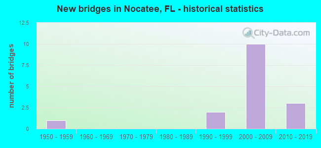
- New bridges - historical statistics
- 11950-1959
- 21990-1999
- 102000-2009
- 32010-2019


- Bridge Condition - Deck
- 44.4%Very good
- 55.6%Good

- Bridge Condition - Superstructure
- 44.4%Very good
- 55.6%Good

- Bridge Condition - Substructure
- 55.6%Very good
- 44.4%Good

- Bridge Condition - Channel
- 83.3%Good
- 16.7%Satisfactory

- Bridge Condition - Culverts
- 50.0%Very good
- 50.0%Satisfactory
Find on map >> Show street view
Structure Number: 780022, Location: 2.8 MI. S. OF CR-210 (Lat: 30.048683, Lng: -81.424644), Route carried "on" structure: US 1, Year Built: 1957, Year Reconstructed: 2002, Status: Open, Structure Length: 0.76m (2.49ft), Average Daily Traffic: 25,500 (year 2020), Truck Traffic: 3%, Average Future Daily Traffic: 44,243 (year 2042), Design Load: HS 20+Mod, Features Intersected: 12 MILE SWAMP
Minimum Vertical Clearance: 30+ m (98+ ft), Kilometerpoint: 17.680, Lanes on structure: 5, Base Highway Network: Yes, Owner: State Highway Agency, Approaching Roadway Width: 18.4m (60.4ft), Skew: 10 degrees, Material/Design: Concrete, Design/Construction: Culvert, Number Of Spans In Main Unit: 2, Length of Maximum Span: 3.7m (12.1ft)
Condition: Channel: Good, Culverts: Satisfactory, Operating Rating: 46.1 metric tons, Method Used To Determine Operating Rating: Load Factor (LF), Inventory Rating: 27.6 metric tons, Method Used To Determine Inventory Rating: Load Factor (LF), Structural Evaluation: Equal to present minimum criteria, Waterway Adequacy: Somewhat better than minimum adequacy, Approach Roadway Alignment: Equal to present desirable criteria, Designated Inspection Frequency: Every 24 months, Inspection Date: June 2021
Find on map >> Show street view
Structure Number: 780107, Location: 0.9 MI. N. OF CR-210 (Lat: 30.098422, Lng: -81.472567), Route carried "on" structure: US 1, Year Built: 1999, Status: Open, Structure Length: 4.85m (15.91ft), Average Daily Traffic: 11,750 (year 2020), Truck Traffic: 3%, Average Future Daily Traffic: 20,386 (year 2042), Design Load: HS 20+Mod, Features Intersected: DURBIN CREEK
Minimum Vertical Clearance: 30+ m (98+ ft), Kilometerpoint: 24.824, Lanes on structure: 2, Base Highway Network: Yes, Owner: State Highway Agency, Approaching Roadway Width: 9.3m (30.5ft), Material/Design: Prestressed concrete, Design/Construction: Stringer/Multi-beam, Number Of Spans In Main Unit: 3, Length of Maximum Span: 16.2m (53.1ft), Curb-To-Curb Width: 12.2m (40.0ft), Out-to-Out Width: 13.1m (43.0ft)
Condition: Deck: Good, Superstructure: Good, Substructure: Good, Channel: Good, Operating Rating: 50.8 metric tons, Method Used To Determine Operating Rating: Load and Resistance Factor (LRFR), Inventory Rating: 34.4 metric tons, Method Used To Determine Inventory Rating: Load and Resistance Factor (LRFR), Structural Evaluation: Better than present minimum criteria, Deck Geometry: Better than present minimum criteria, Waterway Adequacy: Equal to present desirable criteria, Approach Roadway Alignment: Equal to present desirable criteria, Designated Inspection Frequency: Every 24 months, Inspection Date: April 2021, Deck Structure Type: Concrete Cast-file-Place
Find on map >> Show street view
Structure Number: 780108, Location: 0.9 MI. N. OF CR-210 (Lat: 30.098553, Lng: -81.472478), Route carried "on" structure: US 1, Year Built: 1999, Status: Open, Structure Length: 4.85m (15.91ft), Average Daily Traffic: 11,750 (year 2020), Truck Traffic: 3%, Average Future Daily Traffic: 20,386 (year 2042), Design Load: HS 20+Mod, Features Intersected: DURBIN CREEK
Minimum Vertical Clearance: 30+ m (98+ ft), Kilometerpoint: 24.824, Lanes on structure: 2, Base Highway Network: Yes, Owner: State Highway Agency, Approaching Roadway Width: 9.8m (32.2ft), Material/Design: Prestressed concrete, Design/Construction: Stringer/Multi-beam, Number Of Spans In Main Unit: 3, Length of Maximum Span: 16.2m (53.1ft), Curb-To-Curb Width: 12.2m (40.0ft), Out-to-Out Width: 13.1m (43.0ft)
Condition: Deck: Good, Superstructure: Good, Substructure: Good, Channel: Good, Operating Rating: 50.8 metric tons, Method Used To Determine Operating Rating: Load and Resistance Factor (LRFR), Inventory Rating: 34.4 metric tons, Method Used To Determine Inventory Rating: Load and Resistance Factor (LRFR), Structural Evaluation: Better than present minimum criteria, Deck Geometry: Better than present minimum criteria, Waterway Adequacy: Equal to present desirable criteria, Approach Roadway Alignment: Equal to present desirable criteria, Designated Inspection Frequency: Every 24 months, Inspection Date: April 2021, Deck Structure Type: Concrete Cast-file-Place
Find on map >> Show street view
Structure Number: 784055, Location: 5.5 MI NE OF US 1 (Lat: 30.132778, Lng: -81.385556), Route carried "on" structure: County highway 210, Year Built: 2002, Status: Open, Structure Length: 65.17m (213.81ft), Average Daily Traffic: 12,500 (year 2020), Truck Traffic: 2%, Average Future Daily Traffic: 21,688 (year 2042), Features Intersected: ICWW/CLATTER BR RD/ROSCO
Minimum Vertical Clearance: 30+ m (98+ ft), Kilometerpoint: 27.843, Lanes on structure: 4, Lanes under structure: 4, Owner: County Highway Agency, Approaching Roadway Width: 7.1m (23.3ft), Skew: 30 degrees, Navigation Control: Yes ( Vertical Clearance: 0.3m (1.0ft), Horizontal Clearance: 0.3m (1.0ft)), Material/Design: Prestressed concrete continuous, Design/Construction: Stringer/Multi-beam, Number Of Spans In Main Unit: 15, Length of Maximum Span: 88.4m (290.0ft), Curb or Sidewalk Widths: Left: 0.0m, Right: 1.6m (5.2ft), Curb-To-Curb Width: 24.6m (80.7ft), Out-to-Out Width: 27.8m (91.2ft)
Condition: Deck: Good, Superstructure: Good, Substructure: Very good, Channel: Good, Operating Rating: 65.4 metric tons, Method Used To Determine Operating Rating: Load Factor (LF), Inventory Rating: 38.1 metric tons, Method Used To Determine Inventory Rating: Load Factor (LF), Structural Evaluation: Better than present minimum criteria, Deck Geometry: Superior to present desirable criteria, Underclear: Better than present minimum criteria, Waterway Adequacy: Equal to present desirable criteria, Approach Roadway Alignment: Equal to present desirable criteria, Designated Inspection Frequency: Every 24 months, Inspection Date: March 2020, Deck Structure Type: Concrete Cast-file-Place
Find on map >> Show street view
Structure Number: 78406, Location: 2.2 MI NE OF US 1 (Lat: 30.115056, Lng: -81.433278), Route carried "on" structure: County highway 210, Year Built: 2007, Status: Open, Structure Length: 2.29m (7.51ft), Average Daily Traffic: 16,000 (year 2020), Truck Traffic: 4%, Average Future Daily Traffic: 27,760 (year 2042), Design Load: HL 93, Features Intersected: CROSS ROAD, Facility Carried by Structure: NOCATEE PKWY WB
Minimum Vertical Clearance: 30+ m (98+ ft), Kilometerpoint: 0.000, Lanes on structure: 3, Owner: County Highway Agency, Approaching Roadway Width: 17.1m (56.1ft), Material/Design: Prestressed concrete, Design/Construction: Stringer/Multi-beam, Number Of Spans In Main Unit: 1, Length of Maximum Span: 22.9m (75.1ft), Curb-To-Curb Width: 17.2m (56.4ft), Out-to-Out Width: 18.1m (59.4ft)
Condition: Deck: Very good, Superstructure: Very good, Substructure: Very good, Operating Rating: 58.8 metric tons, Method Used To Determine Operating Rating: Load and Resistance Factor (LRFR), Inventory Rating: 46.4 metric tons, Method Used To Determine Inventory Rating: Load and Resistance Factor (LRFR), Structural Evaluation: Equal to present desirable criteria, Deck Geometry: Superior to present desirable criteria, Approach Roadway Alignment: Equal to present desirable criteria, Designated Inspection Frequency: Every 24 months, Inspection Date: June 2020, Deck Structure Type: Concrete Cast-file-Place
Find on map >> Show street view
Structure Number: 784061, Location: 2.2 MI NE OF US 1 (Lat: 30.114778, Lng: -81.433333), Route carried "on" structure: County highway 210, Year Built: 2008, Status: Open, Structure Length: 2.29m (7.51ft), Average Daily Traffic: 16,000 (year 2020), Truck Traffic: 4%, Average Future Daily Traffic: 27,760 (year 2042), Design Load: HL 93, Features Intersected: CROSS ROAD, Facility Carried by Structure: NOCATEE PKWY EB
Minimum Vertical Clearance: 30+ m (98+ ft), Kilometerpoint: 0.000, Lanes on structure: 3, Owner: County Highway Agency, Approaching Roadway Width: 17.1m (56.1ft), Material/Design: Prestressed concrete, Design/Construction: Stringer/Multi-beam, Number Of Spans In Main Unit: 1, Length of Maximum Span: 22.9m (75.1ft), Curb-To-Curb Width: 17.2m (56.4ft), Out-to-Out Width: 18.1m (59.4ft)
Condition: Deck: Very good, Superstructure: Very good, Substructure: Very good, Operating Rating: 58.8 metric tons, Method Used To Determine Operating Rating: Load and Resistance Factor (LRFR), Inventory Rating: 46.4 metric tons, Method Used To Determine Inventory Rating: Load and Resistance Factor (LRFR), Structural Evaluation: Equal to present desirable criteria, Deck Geometry: Superior to present desirable criteria, Approach Roadway Alignment: Equal to present desirable criteria, Designated Inspection Frequency: Every 24 months, Inspection Date: June 2020, Deck Structure Type: Concrete Cast-file-Place
Find on map >> Show street view
Structure Number: 784062, Location: 3.2 MI NE OF US 1 (Lat: 30.114472, Lng: -81.418250), Route carried "on" structure: County highway 210, Year Built: 2007, Status: Open, Structure Length: 8.02m (26.31ft), Average Daily Traffic: 16,000 (year 2020), Truck Traffic: 4%, Average Future Daily Traffic: 27,760 (year 2042), Design Load: HL 93, Features Intersected: CROSSWATER PKWY, Facility Carried by Structure: NOCATEE PKWY WB
Minimum Vertical Clearance: 30+ m (98+ ft), Kilometerpoint: 1.506, Lanes on structure: 2, Lanes under structure: 6, Owner: County Highway Agency, Approaching Roadway Width: 12.2m (40.0ft), Material/Design: Steel, Design/Construction: Stringer/Multi-beam, Number Of Spans In Main Unit: 1, Length of Maximum Span: 80.2m (263.1ft), Curb-To-Curb Width: 12.9m (42.3ft), Out-to-Out Width: 13.8m (45.3ft)
Condition: Deck: Very good, Superstructure: Good, Substructure: Very good, Operating Rating: 35.1 metric tons, Method Used To Determine Operating Rating: Load and Resistance Factor (LRFR), Inventory Rating: 27.0 metric tons, Method Used To Determine Inventory Rating: Load and Resistance Factor (LRFR), Structural Evaluation: Equal to present minimum criteria, Deck Geometry: Superior to present desirable criteria, Underclear: Superior to present desirable criteria, Approach Roadway Alignment: Equal to present desirable criteria, Designated Inspection Frequency: Every 24 months, Inspection Date: June 2020, Deck Structure Type: Concrete Cast-file-Place
Find on map >> Show street view
Structure Number: 784063, Location: 3.2 MI NE OF US 1 (Lat: 30.114194, Lng: -81.418167), Route carried "on" structure: County highway 210, Year Built: 2007, Status: Open, Structure Length: 8.02m (26.31ft), Average Daily Traffic: 16,000 (year 2020), Truck Traffic: 4%, Average Future Daily Traffic: 27,760 (year 2042), Design Load: HL 93, Features Intersected: CROSSWATER PKWY, Facility Carried by Structure: NOCATEE PKWY EB
Minimum Vertical Clearance: 30+ m (98+ ft), Kilometerpoint: 1.503, Lanes on structure: 2, Lanes under structure: 5, Owner: County Highway Agency, Approaching Roadway Width: 12.2m (40.0ft), Material/Design: Steel, Design/Construction: Stringer/Multi-beam, Number Of Spans In Main Unit: 1, Length of Maximum Span: 80.2m (263.1ft), Curb-To-Curb Width: 12.9m (42.3ft), Out-to-Out Width: 13.8m (45.3ft)
Condition: Deck: Very good, Superstructure: Very good, Substructure: Very good, Operating Rating: 35.1 metric tons, Method Used To Determine Operating Rating: Load and Resistance Factor (LRFR), Inventory Rating: 27.0 metric tons, Method Used To Determine Inventory Rating: Load and Resistance Factor (LRFR), Structural Evaluation: Equal to present minimum criteria, Deck Geometry: Superior to present desirable criteria, Underclear: Superior to present desirable criteria, Approach Roadway Alignment: Equal to present desirable criteria, Designated Inspection Frequency: Every 24 months, Inspection Date: June 2020, Deck Structure Type: Concrete Cast-file-Place
Find on map >> Show street view
Structure Number: 784076, Location: 1.2MI W OF VALLEY RIDGE B (Lat: 30.102778, Lng: -81.469444), Route carried "on" structure: County highway , Year Built: 2010, Status: Open, Structure Length: 47.34m (155.31ft), Average Daily Traffic: 7,000 (year 2021), Truck Traffic: 1%, Average Future Daily Traffic: 12,145 (year 2042), Design Load: HL 93, Features Intersected: Durbin Creek, Facility Carried by Structure: Frm Nocatee to Dvl
Minimum Vertical Clearance: 30.18m (99.02ft), Kilometerpoint: 0.795, Lanes on structure: 2, Owner: County Highway Agency, Approaching Roadway Width: 13.5m (44.3ft), Material/Design: Prestressed concrete, Design/Construction: Stringer/Multi-beam, Number Of Spans In Main Unit: 17, Number Of Approach Spans: 1, Length of Maximum Span: 30.3m (99.4ft), Curb-To-Curb Width: 12.4m (40.7ft), Out-to-Out Width: 13.1m (43.0ft)
Condition: Deck: Good, Superstructure: Good, Substructure: Good, Channel: Good, Operating Rating: 36.6 metric tons, Method Used To Determine Operating Rating: Load and Resistance Factor (LRFR), Inventory Rating: 32.7 metric tons, Method Used To Determine Inventory Rating: Load and Resistance Factor (LRFR), Structural Evaluation: Better than present minimum criteria, Deck Geometry: Better than present minimum criteria, Waterway Adequacy: Equal to present desirable criteria, Approach Roadway Alignment: Equal to present minimum criteria, Designated Inspection Frequency: Every 24 months, Inspection Date: April 2021, Deck Structure Type: Concrete Cast-file-Place
Find on map >> Show street view
Structure Number: 78408, Location: CR-210 OVER US-1/FECRR (Lat: 30.090175, Lng: -81.464233), Route carried "on" structure: County highway 210, Year Built: 2014, Status: Open, Structure Length: 11.28m (37.01ft), Average Daily Traffic: 16,500 (year 2020), Truck Traffic: 3%, Average Future Daily Traffic: 28,628 (year 2042), Design Load: HL 93, Features Intersected: US-1 (SR-5)
Minimum Vertical Clearance: 30+ m (98+ ft), Kilometerpoint: 17.019, Lanes on structure: 2, Lanes under structure: 4, Owner: State Highway Agency, Approaching Roadway Width: 13.5m (44.3ft), Material/Design: Steel continuous, Design/Construction: Stringer/Multi-beam, Number Of Spans In Main Unit: 2, Length of Maximum Span: 61.3m (201.1ft), Curb or Sidewalk Widths: Left: 0.0m, Right: 1.5m (4.9ft), Curb-To-Curb Width: 13.4m (44.0ft), Out-to-Out Width: 16.1m (52.8ft)
Condition: Deck: Good, Superstructure: Very good, Substructure: Good, Operating Rating: 48.4 metric tons, Method Used To Determine Operating Rating: Load and Resistance Factor (LRFR), Inventory Rating: 37.2 metric tons, Method Used To Determine Inventory Rating: Load and Resistance Factor (LRFR), Structural Evaluation: Better than present minimum criteria, Deck Geometry: Equal to present minimum criteria, Underclear: Better than present minimum criteria, Approach Roadway Alignment: Equal to present desirable criteria, Designated Inspection Frequency: Every 24 months, Inspection Date: August 2020, Deck Structure Type: Concrete Cast-file-Place
Find on map >> Show street view
Structure Number: 784096, Location: 1 Mi. S of Nocatee Pkwy. (Lat: 30.124489, Lng: -81.427317), Route carried "on" structure: County highway , Year Built: 2006, Status: Open, Structure Length: 0.94m (3.08ft), Average Daily Traffic: 7,200 (year 2021), Truck Traffic: 2%, Average Future Daily Traffic: 12,492 (year 2042), Design Load: HL 93, Features Intersected: WETLANDS, Facility Carried by Structure: VALLEY RIDGE BLVD
Minimum Vertical Clearance: 30+ m (98+ ft), Kilometerpoint: 0.668, Lanes on structure: 2, Owner: County Highway Agency, Approaching Roadway Width: 16.3m (53.5ft), Skew: 21 degrees, Material/Design: Concrete, Design/Construction: Culvert, Number Of Spans In Main Unit: 3, Length of Maximum Span: 2.7m (8.9ft)
Condition: Channel: Satisfactory, Culverts: Very good, Operating Rating: 64.3 metric tons, Method Used To Determine Operating Rating: Load and Resistance Factor (LRFR), Inventory Rating: 41.5 metric tons, Method Used To Determine Inventory Rating: Load and Resistance Factor (LRFR), Structural Evaluation: Equal to present desirable criteria, Waterway Adequacy: Equal to present desirable criteria, Approach Roadway Alignment: Better than present minimum criteria, Designated Inspection Frequency: Every 24 months, Inspection Date: April 2021
Find on map >> Show street view
Structure Number: 784055, Location: 5.5 MI NE OF US 1 (Lat: 30.132778, Lng: -81.385556), Route carried "under" structure: ServiceCounty highway , Year Built: 2002, Structure Length: 0. m, Average Daily Traffic: 50 (year 2016), Features Intersected: ICWW/CLATTER BR RD/ROSCO, Facility Carried by Structure: CR 210
Minimum Vertical Clearance: 12.24m (40.16ft), Kilometerpoint: 0.000, Lanes on structure: 4, Lanes under structure: 2, Material/Design: Prestressed concrete continuous, Design/Construction: Stringer/Multi-beam, Length of Maximum Span: 88.4m (290.0ft)
Find on map >> Show street view
Structure Number: 784055, Location: 5.5 MI NE OF US 1 (Lat: 30.132778, Lng: -81.385556), Route carried "under" structure: ServiceCounty highway 210, Year Built: 2002, Structure Length: 0. m, Average Daily Traffic: 151 (year 2016), Truck Traffic: 1%, Features Intersected: ICWW/CLATTER BR RD/ROSCO
Minimum Vertical Clearance: 15.22m (49.93ft), Kilometerpoint: 0.000, Lanes on structure: 4, Lanes under structure: 2, Material/Design: Prestressed concrete continuous, Design/Construction: Stringer/Multi-beam, Length of Maximum Span: 88.4m (290.0ft)
Find on map >> Show street view
Structure Number: 784062, Location: 3.2 MI NE OF US 1 (Lat: 30.114472, Lng: -81.418250), Route carried "under" structure: County highway , Year Built: 2007, Structure Length: 0. m, Average Daily Traffic: 7,400 (year 2020), Truck Traffic: 4%, Features Intersected: CROSSWATER PKWY, Facility Carried by Structure: NOCATEE PKWY WB
Minimum Vertical Clearance: 5.30m (17.39ft), Kilometerpoint: 2.417, Lanes on structure: 2, Lanes under structure: 6, Material/Design: Steel, Design/Construction: Stringer/Multi-beam, Length of Maximum Span: 80.2m (263.1ft)
Find on map >> Show street view
Structure Number: 784063, Location: 3.2 MI NE OF US 1 (Lat: 30.114194, Lng: -81.418167), Route carried "under" structure: County highway , Year Built: 2007, Structure Length: 0. m, Average Daily Traffic: 7,400 (year 2020), Truck Traffic: 2%, Features Intersected: CROSSWATER PKWY, Facility Carried by Structure: NOCATEE PKWY EB
Minimum Vertical Clearance: 5.52m (18.11ft), Kilometerpoint: 2.459, Lanes on structure: 2, Lanes under structure: 5, Material/Design: Steel, Design/Construction: Stringer/Multi-beam, Length of Maximum Span: 80.2m (263.1ft)
Find on map >> Show street view
Structure Number: 78408, Location: CR-210 OVER US-1/FECRR (Lat: 30.090175, Lng: -81.464233), Route carried "under" structure: US 5, Year Built: 2014, Structure Length: 0. m, Average Daily Traffic: 23,500 (year 2020), Truck Traffic: 3%, Features Intersected: US-1 (SR-5), Facility Carried by Structure: CR 210
Minimum Vertical Clearance: 5.50m (18.04ft), Kilometerpoint: 23.644, Lanes on structure: 2, Lanes under structure: 4, Material/Design: Steel continuous, Design/Construction: Stringer/Multi-beam, Length of Maximum Span: 61.3m (201.1ft)