Bridge Statistics for Niantic, Illinois (IL)
Condition, Traffic, Stress, Structural Evaluation, Project Costs
- National Bridge Inventory (NBI) Statistics
- 19Number of bridges
- 200ft / 61.4mTotal length
- 33,275Total average daily traffic
- 7,131Total average daily truck traffic
- National Bridge Inventory (NBI) Registered Bridges for Niantic
- No street view available for this location
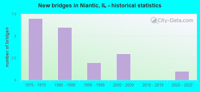
- New bridges - historical statistics
- 71970-1979
- 61980-1989
- 21990-1999
- 32000-2009
- 12020-2022


- Bridge Condition - Deck
- 5.9%Excellent
- 5.9%Very good
- 41.2%Good
- 17.6%Satisfactory
- 23.5%Poor
- 5.9%Serious

- Bridge Condition - Superstructure
- 5.9%Excellent
- 5.9%Very good
- 35.3%Good
- 17.6%Satisfactory
- 5.9%Fair
- 23.5%Poor
- 5.9%Serious

- Bridge Condition - Substructure
- 5.9%Excellent
- 17.6%Very good
- 23.5%Good
- 23.5%Satisfactory
- 23.5%Fair
- 5.9%Critical

- Bridge Condition - Channel
- 33.3%Very good
- 26.7%Good
- 6.7%Satisfactory
- 33.3%Fair
Find on map >> Show street view
Structure Number: 113283, Location: 5.5 M ENE MT AUBURN (Lat: 39.803019, Lng: -89.156225), Route carried "on" structure: County highway , Year Built: 1980, Status: Open, Structure Length: 14.97m (49.11ft), Average Daily Traffic: 550 (year 2021), Truck Traffic: 16%, Average Future Daily Traffic: 701 (year 2032), Design Load: HS 20, Features Intersected: SANGAMON RIVER, Facility Carried by Structure: FAS 644
Minimum Vertical Clearance: 30+ m (98+ ft), Kilometerpoint: 0.016, Lanes on structure: 2, Owner: County Highway Agency, Approaching Roadway Width: 8.2m (26.9ft), Material/Design: Prestressed concrete, Design/Construction: Box Beam or Girders - Multiple, Number Of Spans In Main Unit: 5, Length of Maximum Span: 29.6m (97.1ft), Curb-To-Curb Width: 8.6m (28.2ft), Out-to-Out Width: 9.4m (30.8ft)
Condition: Deck: Good, Superstructure: Fair, Substructure: Very good, Channel: Good, Operating Rating: 51.2 metric tons, Method Used To Determine Operating Rating: Load Factor (LF) rating reported by rating factor (RF) method using MS18 loading, Inventory Rating: 30.8 metric tons, Method Used To Determine Inventory Rating: Load Factor (LF) rating reported by rating factor (RF) method using MS18 loading, Structural Evaluation: Somewhat better than minimum adequacy, Deck Geometry: Somewhat better than minimum adequacy, Waterway Adequacy: Equal to present desirable criteria, Approach Roadway Alignment: Equal to present desirable criteria, Designated Inspection Frequency: Every 24 months, Underwater Inspection Frequency: Every 60 months, Inspection Date: November 2019, Underwater Inspection Date: October 2016, Deck Structure Type: Concrete Cast-file-Place
Find on map >> Show street view
Structure Number: 58006, Location: 1.5 MI SW NIANTIC (Lat: 39.836511, Lng: -89.198750), Route carried "on" structure: County highway , Year Built: 1976, Status: Open, Structure Length: 7.88m (25.85ft), Average Daily Traffic: 50 (year 2020), Truck Traffic: 6%, Average Future Daily Traffic: 103 (year 2032), Design Load: HS 15, Features Intersected: I-72, Facility Carried by Structure: TR 4(ACOM RD)
Minimum Vertical Clearance: 30+ m (98+ ft), Kilometerpoint: 8.916, Lanes on structure: 2, Lanes under structure: 4, Owner: State Highway Agency, Approaching Roadway Width: 5.5m (18.0ft), Material/Design: Steel continuous, Design/Construction: Box Beam or Girders - Single/Spread, Number Of Spans In Main Unit: 2, Length of Maximum Span: 31.9m (104.7ft), Curb-To-Curb Width: 8.1m (26.6ft), Out-to-Out Width: 9.1m (29.9ft)
Condition: Deck: Good, Superstructure: Good, Substructure: Good, Operating Rating: 70.0 metric tons, Method Used To Determine Operating Rating: Load Factor (LF) rating reported by rating factor (RF) method using MS18 loading, Inventory Rating: 41.8 metric tons, Method Used To Determine Inventory Rating: Load Factor (LF) rating reported by rating factor (RF) method using MS18 loading, Structural Evaluation: Better than present minimum criteria, Deck Geometry: Equal to present minimum criteria, Underclear: Somewhat better than minimum adequacy, Approach Roadway Alignment: Equal to present desirable criteria, Designated Inspection Frequency: Every 24 months, Critical Feature Inspection Frequency: Every 24 months, Inspection Date: July 2020, Critical Feature Inspection Date: April 2021, Deck Structure Type: Concrete Cast-file-Place, Wearing Surface/Protective System: Wearing Surface: Bituminous, Membrane: Built-up
Find on map >> Show street view
Structure Number: 580061, Location: 1 MI S OF NIANTIC (Lat: 39.834433, Lng: -89.156492), Route carried "on" structure: County highway , Year Built: 1976, Status: Open, Structure Length: 8.35m (27.40ft), Average Daily Traffic: 625 (year 2020), Truck Traffic: 22%, Average Future Daily Traffic: 722 (year 2032), Design Load: HS 20, Features Intersected: I-72, Facility Carried by Structure: CH 55(FAS 644)
Minimum Vertical Clearance: 30+ m (98+ ft), Kilometerpoint: 1.062, Lanes on structure: 2, Lanes under structure: 4, Owner: State Highway Agency, Approaching Roadway Width: 14.0m (45.9ft), Skew: 31 degrees, Material/Design: Steel continuous, Design/Construction: Stringer/Multi-beam, Number Of Spans In Main Unit: 2, Number Of Approach Spans: 2, Length of Maximum Span: 33.5m (109.9ft), Curb-To-Curb Width: 13.6m (44.6ft), Out-to-Out Width: 19.5m (64.0ft)
Condition: Deck: Good, Superstructure: Good, Substructure: Satisfactory, Operating Rating: 57.7 metric tons, Method Used To Determine Operating Rating: Load Factor (LF) rating reported by rating factor (RF) method using MS18 loading, Inventory Rating: 34.7 metric tons, Method Used To Determine Inventory Rating: Load Factor (LF) rating reported by rating factor (RF) method using MS18 loading, Structural Evaluation: Equal to present minimum criteria, Deck Geometry: Superior to present desirable criteria, Underclear: Somewhat better than minimum adequacy, Approach Roadway Alignment: Equal to present desirable criteria, Designated Inspection Frequency: Every 24 months, Inspection Date: September 2020, Deck Structure Type: Concrete Cast-file-Place, Wearing Surface/Protective System: Wearing Surface: Other
Find on map >> Show street view
Structure Number: 583198, Location: 3.3 MI S NIANTIC (Lat: 39.807506, Lng: -89.156169), Route carried "on" structure: County highway , Year Built: 1979, Status: Open, Structure Length: 3.43m (11.25ft), Average Daily Traffic: 600 (year 2020), Truck Traffic: 22%, Average Future Daily Traffic: 619 (year 2032), Design Load: HS 20, Features Intersected: OVERFLOW OF SANGAMON, Facility Carried by Structure: FAS 644(CH 55)
Minimum Vertical Clearance: 30+ m (98+ ft), Kilometerpoint: 4.104, Lanes on structure: 2, Owner: County Highway Agency, Approaching Roadway Width: 6.9m (22.6ft), Material/Design: Prestressed concrete, Design/Construction: Box Beam or Girders - Multiple, Number Of Spans In Main Unit: 3, Length of Maximum Span: 11.3m (37.1ft), Curb-To-Curb Width: 8.5m (27.9ft), Out-to-Out Width: 8.5m (27.9ft)
Condition: Deck: Poor, Superstructure: Poor, Substructure: Satisfactory, Channel: Satisfactory, Operating Rating: 52.5 metric tons, Method Used To Determine Operating Rating: Load Factor (LF) rating reported by rating factor (RF) method using MS18 loading, Inventory Rating: 31.4 metric tons, Method Used To Determine Inventory Rating: Load Factor (LF) rating reported by rating factor (RF) method using MS18 loading, Structural Evaluation: Meets minimum limits, Deck Geometry: Somewhat better than minimum adequacy, Waterway Adequacy: Equal to present desirable criteria, Approach Roadway Alignment: Equal to present desirable criteria, Designated Inspection Frequency: Every 24 months, Inspection Date: January 2022, Deck Structure Type: Concrete Precast Panels, Wearing Surface/Protective System: Wearing Surface: Bituminous
Find on map >> Show street view
Structure Number: 583224, Location: N EDGE OF NIANTIC (Lat: 39.859058, Lng: -89.161181), Route carried "on" structure: County highway , Year Built: 1978, Status: Posted for load, Structure Length: 2.44m (8.01ft), Average Daily Traffic: 700 (year 2020), Truck Traffic: 20%, Average Future Daily Traffic: 1,650 (year 2032), Design Load: HS 20, Features Intersected: WILLOW BRANCH, Facility Carried by Structure: CH 19 EXTENSION IL
Minimum Vertical Clearance: 30+ m (98+ ft), Kilometerpoint: 6.550, Lanes on structure: 2, Owner: City or Municipal Highway Agency, Approaching Roadway Width: 6.6m (21.7ft), Skew: 2 degrees, Material/Design: Prestressed concrete, Design/Construction: Box Beam or Girders - Multiple, Number Of Spans In Main Unit: 2, Length of Maximum Span: 11.8m (38.7ft), Curb-To-Curb Width: 8.5m (27.9ft), Out-to-Out Width: 8.6m (28.2ft)
Condition: Deck: Poor, Superstructure: Poor, Substructure: Critical, Channel: Good, Operating Rating: 16.2 metric tons, Method Used To Determine Operating Rating: Load Factor (LF) rating reported by rating factor (RF) method using MS18 loading, Inventory Rating: 9.7 metric tons, Method Used To Determine Inventory Rating: Load Factor (LF) rating reported by rating factor (RF) method using MS18 loading, Structural Evaluation: High priority of replacement, Deck Geometry: Somewhat better than minimum adequacy, Waterway Adequacy: Equal to present desirable criteria, Approach Roadway Alignment: Equal to present desirable criteria, Bridge Posting: Required (Relationship of Operating Rating to Maximum Legal Load: > 39.9% below), Designated Inspection Frequency: Every 24 months, Other Special Inspection Frequency: Every 12 months, Inspection Date: Febuary 2022, Other Special Inspection Date: August 2021, Deck Structure Type: Concrete Precast Panels, Wearing Surface/Protective System: Wearing Surface: Bituminous, Membrane: Built-up
Find on map >> Show street view
Structure Number: 583241, Location: 3 MI S OF NIANTIC (Lat: 39.811847, Lng: -89.156172), Route carried "on" structure: County highway , Year Built: 1979, Status: Open, Structure Length: 3.43m (11.25ft), Average Daily Traffic: 575 (year 2020), Truck Traffic: 21%, Average Future Daily Traffic: 619 (year 2032), Design Load: HS 20, Features Intersected: OVERFLOW SANGAMON R, Facility Carried by Structure: FAS 644(CH 55)
Minimum Vertical Clearance: 30+ m (98+ ft), Kilometerpoint: 3.637, Lanes on structure: 2, Owner: County Highway Agency, Approaching Roadway Width: 6.6m (21.7ft), Material/Design: Prestressed concrete, Design/Construction: Box Beam or Girders - Multiple, Number Of Spans In Main Unit: 3, Length of Maximum Span: 11.3m (37.1ft), Curb-To-Curb Width: 8.5m (27.9ft), Out-to-Out Width: 8.5m (27.9ft)
Condition: Deck: Serious, Superstructure: Serious, Substructure: Satisfactory, Channel: Good, Operating Rating: 46.7 metric tons, Method Used To Determine Operating Rating: Load Factor (LF) rating reported by rating factor (RF) method using MS18 loading, Inventory Rating: 27.9 metric tons, Method Used To Determine Inventory Rating: Load Factor (LF) rating reported by rating factor (RF) method using MS18 loading, Structural Evaluation: High priority of corrective action, Deck Geometry: Somewhat better than minimum adequacy, Waterway Adequacy: Equal to present desirable criteria, Approach Roadway Alignment: Equal to present desirable criteria, Designated Inspection Frequency: Every 24 months, Inspection Date: January 2022, Deck Structure Type: Concrete Precast Panels, Wearing Surface/Protective System: Wearing Surface: Bituminous, Membrane: Built-up
Find on map >> Show street view
Structure Number: 583258, Location: 1.7 MI W NIANTIC (Lat: 39.860192, Lng: -89.198683), Route carried "on" structure: County highway , Year Built: 1985, Status: Open, Structure Length: 2.77m (9.09ft), Average Daily Traffic: 100 (year 2020), Truck Traffic: 6%, Average Future Daily Traffic: 103 (year 2032), Design Load: HS 20, Features Intersected: WILLOW BRANCH, Facility Carried by Structure: TR 4(ACOM ROAD)
Minimum Vertical Clearance: 30+ m (98+ ft), Kilometerpoint: 6.325, Lanes on structure: 2, Owner: Town or Township Highway Agency, Approaching Roadway Width: 4.5m (14.8ft), Material/Design: Prestressed concrete, Design/Construction: Box Beam or Girders - Multiple, Number Of Spans In Main Unit: 2, Length of Maximum Span: 13.7m (44.9ft), Curb-To-Curb Width: 7.3m (24.0ft), Out-to-Out Width: 7.3m (24.0ft)
Condition: Deck: Good, Superstructure: Good, Substructure: Fair, Channel: Fair, Operating Rating: 44.4 metric tons, Method Used To Determine Operating Rating: Assigned rating based on Load Factor Design (LFD) reported by rating factor (RF) using MS18 loading, Inventory Rating: 32.4 metric tons, Method Used To Determine Inventory Rating: Assigned rating based on Load Factor Design (LFD) reported by rating factor (RF) using MS18 loading, Structural Evaluation: Somewhat better than minimum adequacy, Deck Geometry: Equal to present minimum criteria, Waterway Adequacy: Equal to present minimum criteria, Approach Roadway Alignment: Equal to present minimum criteria, Designated Inspection Frequency: Every 24 months, Inspection Date: Febuary 2021, Deck Structure Type: Concrete Precast Panels, Wearing Surface/Protective System: Wearing Surface: Gravel
Find on map >> Show street view
Structure Number: 583259, Location: 1 MI NW NIANTIC (Lat: 39.862581, Lng: -89.179961), Route carried "on" structure: County highway , Year Built: 1983, Status: Open, Structure Length: 1.75m (5.74ft), Average Daily Traffic: 50 (year 2020), Truck Traffic: 6%, Average Future Daily Traffic: 77 (year 2032), Design Load: HS 20, Features Intersected: WILLOW BRANCH, Facility Carried by Structure: TR 8(MOONEY RD)
Minimum Vertical Clearance: 30+ m (98+ ft), Kilometerpoint: 6.099, Lanes on structure: 2, Owner: Town or Township Highway Agency, Approaching Roadway Width: 4.6m (15.1ft), Material/Design: Prestressed concrete, Design/Construction: Box Beam or Girders - Multiple, Number Of Spans In Main Unit: 1, Length of Maximum Span: 16.7m (54.8ft), Curb-To-Curb Width: 7.3m (24.0ft), Out-to-Out Width: 7.4m (24.3ft)
Condition: Deck: Good, Superstructure: Good, Substructure: Fair, Channel: Fair, Operating Rating: 44.4 metric tons, Method Used To Determine Operating Rating: Assigned rating based on Load Factor Design (LFD) reported by rating factor (RF) using MS18 loading, Inventory Rating: 32.4 metric tons, Method Used To Determine Inventory Rating: Assigned rating based on Load Factor Design (LFD) reported by rating factor (RF) using MS18 loading, Structural Evaluation: Somewhat better than minimum adequacy, Deck Geometry: Equal to present minimum criteria, Waterway Adequacy: Equal to present minimum criteria, Approach Roadway Alignment: Better than present minimum criteria, Designated Inspection Frequency: Every 24 months, Inspection Date: January 2022, Deck Structure Type: Concrete Precast Panels, Wearing Surface/Protective System: Wearing Surface: Gravel
Find on map >> Show street view
Structure Number: 58326, Location: 1 MI NW NIANTIC (Lat: 39.871114, Lng: -89.180050), Route carried "on" structure: County highway , Year Built: 1983, Status: Open, Structure Length: 2.12m (6.96ft), Average Daily Traffic: 50 (year 2020), Truck Traffic: 6%, Average Future Daily Traffic: 77 (year 2032), Design Load: HS 20, Features Intersected: WILLOW BRANCH, Facility Carried by Structure: TR 8(MOONEY RD)
Minimum Vertical Clearance: 30+ m (98+ ft), Kilometerpoint: 5.150, Lanes on structure: 2, Owner: Town or Township Highway Agency, Approaching Roadway Width: 4.7m (15.4ft), Skew: 2 degrees, Material/Design: Prestressed concrete, Design/Construction: Box Beam or Girders - Multiple, Number Of Spans In Main Unit: 1, Length of Maximum Span: 20.4m (66.9ft), Curb-To-Curb Width: 7.3m (24.0ft), Out-to-Out Width: 7.4m (24.3ft)
Condition: Deck: Satisfactory, Superstructure: Satisfactory, Substructure: Good, Channel: Fair, Operating Rating: 44.4 metric tons, Method Used To Determine Operating Rating: Assigned rating based on Load Factor Design (LFD) reported by rating factor (RF) using MS18 loading, Inventory Rating: 32.4 metric tons, Method Used To Determine Inventory Rating: Assigned rating based on Load Factor Design (LFD) reported by rating factor (RF) using MS18 loading, Structural Evaluation: Equal to present minimum criteria, Deck Geometry: Equal to present minimum criteria, Waterway Adequacy: Equal to present minimum criteria, Approach Roadway Alignment: Better than present minimum criteria, Designated Inspection Frequency: Every 24 months, Inspection Date: January 2022, Deck Structure Type: Concrete Precast Panels, Wearing Surface/Protective System: Wearing Surface: Gravel
Find on map >> Show street view
Structure Number: 583261, Location: 2.6 MI NE NIANTIC (Lat: 39.888239, Lng: -89.143103), Route carried "on" structure: County highway , Year Built: 1982, Status: Open, Structure Length: 2.11m (6.92ft), Average Daily Traffic: 75 (year 2020), Truck Traffic: 9%, Average Future Daily Traffic: 77 (year 2032), Design Load: HS 20, Features Intersected: WILLOW BRANCH, Facility Carried by Structure: TR 20A(N 3RD P M
Minimum Vertical Clearance: 30+ m (98+ ft), Kilometerpoint: 7.934, Lanes on structure: 2, Owner: Town or Township Highway Agency, Approaching Roadway Width: 4.7m (15.4ft), Material/Design: Prestressed concrete, Design/Construction: Box Beam or Girders - Multiple, Number Of Spans In Main Unit: 1, Length of Maximum Span: 20.4m (66.9ft), Curb-To-Curb Width: 7.3m (24.0ft), Out-to-Out Width: 7.4m (24.3ft)
Condition: Deck: Satisfactory, Superstructure: Satisfactory, Substructure: Fair, Channel: Fair, Operating Rating: 44.4 metric tons, Method Used To Determine Operating Rating: Assigned rating based on Load Factor Design (LFD) reported by rating factor (RF) using MS18 loading, Inventory Rating: 32.4 metric tons, Method Used To Determine Inventory Rating: Assigned rating based on Load Factor Design (LFD) reported by rating factor (RF) using MS18 loading, Structural Evaluation: Somewhat better than minimum adequacy, Deck Geometry: Equal to present minimum criteria, Waterway Adequacy: Equal to present minimum criteria, Approach Roadway Alignment: Equal to present minimum criteria, Designated Inspection Frequency: Every 24 months, Inspection Date: January 2022, Deck Structure Type: Concrete Precast Panels, Wearing Surface/Protective System: Wearing Surface: Gravel
Find on map >> Show street view
Structure Number: 5833, Location: 3 MI S OF NIANTIC (Lat: 39.806861, Lng: -89.142317), Route carried "on" structure: County highway , Year Built: 1988, Status: Open, Structure Length: 1.63m (5.35ft), Average Daily Traffic: 50 (year 2020), Truck Traffic: 8%, Average Future Daily Traffic: 26 (year 2032), Design Load: HS 20, Features Intersected: SANGAMON RIVER TRIB, Facility Carried by Structure: TR 177(RIVER RD)
Minimum Vertical Clearance: 30+ m (98+ ft), Kilometerpoint: 1.448, Lanes on structure: 2, Owner: Town or Township Highway Agency, Approaching Roadway Width: 4.1m (13.5ft), Skew: 3 degrees, Material/Design: Prestressed concrete, Design/Construction: Box Beam or Girders - Multiple, Number Of Spans In Main Unit: 1, Length of Maximum Span: 15.2m (49.9ft), Curb-To-Curb Width: 7.6m (24.9ft), Out-to-Out Width: 7.6m (24.9ft)
Condition: Deck: Poor, Superstructure: Poor, Substructure: Fair, Channel: Fair, Operating Rating: 44.4 metric tons, Method Used To Determine Operating Rating: Load Factor (LF) rating reported by rating factor (RF) method using MS18 loading, Inventory Rating: 26.6 metric tons, Method Used To Determine Inventory Rating: Load Factor (LF) rating reported by rating factor (RF) method using MS18 loading, Structural Evaluation: Meets minimum limits, Deck Geometry: Equal to present minimum criteria, Waterway Adequacy: Equal to present minimum criteria, Approach Roadway Alignment: Equal to present minimum criteria, Designated Inspection Frequency: Every 24 months, Inspection Date: January 2022, Deck Structure Type: Concrete Precast Panels, Wearing Surface/Protective System: Wearing Surface: Gravel
Find on map >> Show street view
Structure Number: 583329, Location: 3.1 MI NE NIANTIC (Lat: 39.888825, Lng: -89.122175), Route carried "on" structure: County highway , Year Built: 1995, Status: Open, Structure Length: 1.47m (4.82ft), Average Daily Traffic: 25 (year 2020), Truck Traffic: 8%, Average Future Daily Traffic: 26 (year 2032), Design Load: HS 20, Features Intersected: WILLOW BRANCH, Facility Carried by Structure: TR 75
Minimum Vertical Clearance: 30+ m (98+ ft), Kilometerpoint: 0.257, Lanes on structure: 2, Owner: Town or Township Highway Agency, Approaching Roadway Width: 6.1m (20.0ft), Material/Design: Prestressed concrete, Design/Construction: Box Beam or Girders - Multiple, Number Of Spans In Main Unit: 1, Length of Maximum Span: 14.6m (47.9ft), Curb-To-Curb Width: 7.3m (24.0ft), Out-to-Out Width: 7.3m (24.0ft)
Condition: Deck: Good, Superstructure: Good, Substructure: Good, Channel: Very good, Operating Rating: 44.1 metric tons, Method Used To Determine Operating Rating: Assigned rating based on Load Factor Design (LFD) reported by rating factor (RF) using MS18 loading, Inventory Rating: 32.4 metric tons, Method Used To Determine Inventory Rating: Assigned rating based on Load Factor Design (LFD) reported by rating factor (RF) using MS18 loading, Structural Evaluation: Better than present minimum criteria, Deck Geometry: Equal to present minimum criteria, Waterway Adequacy: Equal to present desirable criteria, Approach Roadway Alignment: Equal to present desirable criteria, Designated Inspection Frequency: Every 48 months, Inspection Date: Febuary 2019, Deck Structure Type: Concrete Precast Panels, Wearing Surface/Protective System: Wearing Surface: Gravel
Find on map >> Show street view
Structure Number: 583338, Location: 1.2 MI E OF NIANTIC (Lat: 39.861733, Lng: -89.142897), Route carried "on" structure: County highway , Year Built: 1995, Status: Open, Structure Length: 1.60m (5.25ft), Average Daily Traffic: 75 (year 2020), Truck Traffic: 9%, Average Future Daily Traffic: 77 (year 2032), Design Load: HS 20, Features Intersected: STREAM, Facility Carried by Structure: TR 20 A
Minimum Vertical Clearance: 30+ m (98+ ft), Kilometerpoint: 10.879, Lanes on structure: 2, Owner: Town or Township Highway Agency, Approaching Roadway Width: 5.5m (18.0ft), Material/Design: Prestressed concrete, Design/Construction: Box Beam or Girders - Multiple, Number Of Spans In Main Unit: 1, Length of Maximum Span: 15.3m (50.2ft), Curb-To-Curb Width: 7.3m (24.0ft), Out-to-Out Width: 7.3m (24.0ft)
Condition: Deck: Satisfactory, Superstructure: Satisfactory, Substructure: Satisfactory, Channel: Good, Operating Rating: 44.1 metric tons, Method Used To Determine Operating Rating: Assigned rating based on Load Factor Design (LFD) reported by rating factor (RF) using MS18 loading, Inventory Rating: 32.4 metric tons, Method Used To Determine Inventory Rating: Assigned rating based on Load Factor Design (LFD) reported by rating factor (RF) using MS18 loading, Structural Evaluation: Equal to present minimum criteria, Deck Geometry: Equal to present minimum criteria, Waterway Adequacy: Equal to present desirable criteria, Approach Roadway Alignment: Equal to present minimum criteria, Designated Inspection Frequency: Every 24 months, Inspection Date: January 2022, Deck Structure Type: Concrete Precast Panels
Find on map >> Show street view
Structure Number: 583346, Location: .5 MI E OF NIANTIC (Lat: 39.859336, Lng: -89.148456), Route carried "on" structure: County highway , Year Built: 2001, Status: Open, Structure Length: 2.04m (6.69ft), Average Daily Traffic: 75 (year 2020), Truck Traffic: 3%, Average Future Daily Traffic: 103 (year 2032), Design Load: HS 20, Features Intersected: Trib Long Pt Slough, Facility Carried by Structure: TR 109 A
Minimum Vertical Clearance: 30+ m (98+ ft), Kilometerpoint: 0.595, Lanes on structure: 2, Owner: Town or Township Highway Agency, Approaching Roadway Width: 5.8m (19.0ft), Skew: 3 degrees, Material/Design: Prestressed concrete, Design/Construction: Box Beam or Girders - Multiple, Number Of Spans In Main Unit: 1, Length of Maximum Span: 19.4m (63.6ft), Curb-To-Curb Width: 7.3m (24.0ft), Out-to-Out Width: 7.5m (24.6ft)
Condition: Deck: Poor, Superstructure: Poor, Substructure: Good, Channel: Very good, Operating Rating: 65.1 metric tons, Method Used To Determine Operating Rating: Load Factor (LF) rating reported by rating factor (RF) method using MS18 loading, Inventory Rating: 38.9 metric tons, Method Used To Determine Inventory Rating: Load Factor (LF) rating reported by rating factor (RF) method using MS18 loading, Structural Evaluation: Meets minimum limits, Deck Geometry: Equal to present minimum criteria, Waterway Adequacy: Equal to present desirable criteria, Approach Roadway Alignment: Equal to present desirable criteria, Designated Inspection Frequency: Every 24 months, Inspection Date: Febuary 2022, Deck Structure Type: Concrete Precast Panels
Find on map >> Show street view
Structure Number: 583368, Location: 1.9 MI N NIANTIC (Lat: 39.881511, Lng: -89.161889), Route carried "on" structure: County highway , Year Built: 2007, Status: Open, Structure Length: 2.16m (7.09ft), Average Daily Traffic: 300 (year 2020), Truck Traffic: 10%, Average Future Daily Traffic: 361 (year 2032), Design Load: HS 20, Features Intersected: WILLOW BRANCH, Facility Carried by Structure: CH 19 (FAS 555)
Minimum Vertical Clearance: 30+ m (98+ ft), Kilometerpoint: 4.007, Lanes on structure: 2, Owner: County Highway Agency, Approaching Roadway Width: 6.1m (20.0ft), Material/Design: Prestressed concrete, Design/Construction: Box Beam or Girders - Multiple, Number Of Spans In Main Unit: 1, Length of Maximum Span: 20.9m (68.6ft), Curb-To-Curb Width: 7.3m (24.0ft), Out-to-Out Width: 7.4m (24.3ft)
Condition: Deck: Good, Superstructure: Good, Substructure: Very good, Channel: Very good, Operating Rating: 44.1 metric tons, Method Used To Determine Operating Rating: Assigned rating based on Load Factor Design (LFD) reported by rating factor (RF) using MS18 loading, Inventory Rating: 32.4 metric tons, Method Used To Determine Inventory Rating: Assigned rating based on Load Factor Design (LFD) reported by rating factor (RF) using MS18 loading, Structural Evaluation: Better than present minimum criteria, Deck Geometry: Somewhat better than minimum adequacy, Waterway Adequacy: Equal to present desirable criteria, Approach Roadway Alignment: Equal to present desirable criteria, Designated Inspection Frequency: Every 48 months, Inspection Date: Febuary 2018, Deck Structure Type: Concrete Precast Panels, Wearing Surface/Protective System: Wearing Surface: Bituminous, Membrane: Built-up
Find on map >> Show street view
Structure Number: 58339, Location: 3.2 MI SE NIANTIC (Lat: 39.808875, Lng: -89.142064), Route carried "on" structure: County highway , Year Built: 2008, Status: Open, Structure Length: 1.26m (4.13ft), Average Daily Traffic: 25 (year 2020), Truck Traffic: 8%, Average Future Daily Traffic: 26 (year 2032), Design Load: HS 20, Features Intersected: Trib Sangamon River, Facility Carried by Structure: TR 153
Minimum Vertical Clearance: 30+ m (98+ ft), Kilometerpoint: 7.371, Lanes on structure: 2, Owner: Town or Township Highway Agency, Approaching Roadway Width: 4.6m (15.1ft), Skew: 1 degrees, Material/Design: Prestressed concrete, Design/Construction: Box Beam or Girders - Multiple, Number Of Spans In Main Unit: 1, Length of Maximum Span: 11.8m (38.7ft), Curb-To-Curb Width: 7.3m (24.0ft), Out-to-Out Width: 7.4m (24.3ft)
Condition: Deck: Very good, Superstructure: Very good, Substructure: Very good, Channel: Very good, Operating Rating: 44.1 metric tons, Method Used To Determine Operating Rating: Assigned rating based on Load Factor Design (LFD) reported by rating factor (RF) using MS18 loading, Inventory Rating: 32.4 metric tons, Method Used To Determine Inventory Rating: Assigned rating based on Load Factor Design (LFD) reported by rating factor (RF) using MS18 loading, Structural Evaluation: Equal to present desirable criteria, Deck Geometry: Equal to present minimum criteria, Waterway Adequacy: Better than present minimum criteria, Approach Roadway Alignment: Equal to present minimum criteria, Designated Inspection Frequency: Every 48 months, Inspection Date: Febuary 2018, Deck Structure Type: Concrete Precast Panels, Wearing Surface/Protective System: Wearing Surface: Integral Concrete
Find on map >> Show street view
Structure Number: 583413, Location: 3.25 MI NE NIANTIC (Lat: 39.890264, Lng: -89.125181), Route carried "on" structure: County highway , Year Built: 2021, Status: Open, Structure Length: 1.94m (6.36ft), Average Daily Traffic: 50 (year 2020), Truck Traffic: 2%, Average Future Daily Traffic: 52 (year 2032), Design Load: HS 25 or greater, Features Intersected: WILLOW BRANCH, Facility Carried by Structure: TR 30A(STRAWN RD)
Minimum Vertical Clearance: 30+ m (98+ ft), Kilometerpoint: 7.918, Lanes on structure: 2, Owner: Town or Township Highway Agency, Approaching Roadway Width: 7.3m (24.0ft), Skew: 2 degrees, Material/Design: Prestressed concrete, Design/Construction: Box Beam or Girders - Multiple, Number Of Spans In Main Unit: 1, Length of Maximum Span: 0.0m, Curb-To-Curb Width: 7.3m (24.0ft), Out-to-Out Width: 7.3m (24.0ft)
Condition: Deck: Excellent, Superstructure: Excellent, Substructure: Excellent, Channel: Very good, Operating Rating: 66.7 metric tons, Method Used To Determine Operating Rating: Load and Resistance Factor Rating (LRFR) rating reported by rating factor(RF) method using HL-93 loadings, Inventory Rating: 51.5 metric tons, Method Used To Determine Inventory Rating: Load and Resistance Factor Rating (LRFR) rating reported by rating factor(RF) method using HL-93 loadings, Structural Evaluation: Superior to present desirable criteria, Deck Geometry: Equal to present minimum criteria, Waterway Adequacy: Equal to present desirable criteria, Approach Roadway Alignment: Equal to present desirable criteria, Designated Inspection Frequency: Every 24 months, Inspection Date: November 2021, Deck Structure Type: Concrete Precast Panels, Wearing Surface/Protective System: Wearing Surface: Gravel
Find on map >> Show street view
Structure Number: 58006, Location: 1.5 MI SW NIANTIC (Lat: 39.836511, Lng: -89.198750), Route carried "under" structure: Interstate 72, Year Built: 1976, Structure Length: 0. m, Average Daily Traffic: 14,400 (year 2021), Truck Traffic: 22%, Features Intersected: I-72, Facility Carried by Structure: TR 4(ACOM RD)
Minimum Vertical Clearance: 5.00m (16.40ft), Kilometerpoint: 202.209, Lanes on structure: 2, Lanes under structure: 4, Material/Design: Steel continuous, Design/Construction: Box Beam or Girders - Single/Spread, Length of Maximum Span: 31.9m (104.7ft)
Find on map >> Show street view
Structure Number: 580061, Location: 1 MI S OF NIANTIC (Lat: 39.834433, Lng: -89.156492), Route carried "under" structure: Interstate 72, Year Built: 1976, Structure Length: 0. m, Average Daily Traffic: 14,900 (year 2021), Truck Traffic: 22%, Features Intersected: I-72, Facility Carried by Structure: CH 55(FAS 644)
Minimum Vertical Clearance: 4.98m (16.34ft), Kilometerpoint: 205.878, Lanes on structure: 2, Lanes under structure: 4, Material/Design: Steel continuous, Design/Construction: Stringer/Multi-beam, Length of Maximum Span: 33.5m (109.9ft)