Bridge Statistics for Newtown, Pennsylvania (PA)
Condition, Traffic, Stress, Structural Evaluation, Project Costs
- National Bridge Inventory (NBI) Statistics
- 11Number of bridges
- 66ft / 20.4mTotal length
- $4,821,000Total costs
- 145,957Total average daily traffic
- 8,777Total average daily truck traffic
- National Bridge Inventory (NBI) Registered Bridges for Newtown
- No street view available for this location
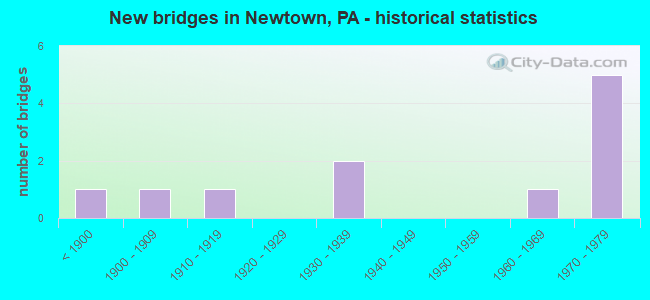
- New bridges - historical statistics
- 1Before 1900
- 11900-1909
- 11910-1919
- 21930-1939
- 11960-1969
- 51970-1979

- Reconstructed bridges - Historical Statistics
- 1Before 1900
- 01900-1909
- 01910-1919
- 01920-1929
- 01930-1939
- 01940-1949
- 01950-1959
- 11960-1969
- 01970-1979
- 01980-1989
- 11990-1999
- 12000-2009


- Bridge Condition - Deck
- 16.7%Good
- 66.7%Satisfactory
- 16.7%Fair

- Bridge Condition - Superstructure
- 12.5%Very good
- 12.5%Good
- 50.0%Satisfactory
- 25.0%Fair

- Bridge Condition - Substructure
- 12.5%Good
- 50.0%Satisfactory
- 37.5%Fair

- Bridge Condition - Channel
- 28.6%Satisfactory
- 28.6%Fair
- 42.9%Poor
Find on map >> Show street view
Structure Number: 7003, Location: .4MI.WEST LR 152 36J03 (Lat: 40.217278, Lng: -74.939889), Route carried "on" structure: State highway 332, Year Built: 1974, Status: Open, Structure Length: 0.85m (2.79ft), Average Daily Traffic: 40,464 (year 2022), Truck Traffic: 8%, Average Future Daily Traffic: 45,374 (year 2032), Design Load: HS 20, Features Intersected: NEWTOWN CREEK, Facility Carried by Structure: NEWTOWN BY-PASS
Minimum Vertical Clearance: 30+ m (98+ ft), Kilometerpoint: 16.599, Lanes on structure: 2, Base Highway Network: Yes, Owner: State Highway Agency, Approaching Roadway Width: 27.1m (88.9ft), Skew: 31 degrees, Material/Design: Steel, Design/Construction: Culvert, Number Of Spans In Main Unit: 1, Length of Maximum Span: 7.9m (25.9ft)
Condition: Channel: Poor, Culverts: Satisfactory, Operating Rating: 76.2 metric tons, Method Used To Determine Operating Rating: Field evaluation and documented engineering judgment, Inventory Rating: 38.1 metric tons, Method Used To Determine Inventory Rating: Field evaluation and documented engineering judgment, Structural Evaluation: Equal to present minimum criteria, Waterway Adequacy: Superior to present desirable criteria, Approach Roadway Alignment: Equal to present desirable criteria, Length Of Structure Improvement: 1.50m (4.92ft), Designated Inspection Frequency: Every 24 months, Inspection Date: October 2021
Find on map >> Show street view
Structure Number: 7004, Location: .25MI.W.OF LR 152 36K03 (Lat: 40.216667, Lng: -74.936667), Route carried "on" structure: State highway 332, Year Built: 1974, Status: Open, Structure Length: 4.82m (15.81ft), Average Daily Traffic: 40,464 (year 2022), Truck Traffic: 8%, Average Future Daily Traffic: 45,374 (year 2032), Design Load: HS 20, Features Intersected: SEPTA; ACCESS ROAD, Facility Carried by Structure: NEWTOWN BY-PASS
Minimum Vertical Clearance: 30+ m (98+ ft), Kilometerpoint: 17.255, Lanes on structure: 4, Lanes under structure: 2, Base Highway Network: Yes, Owner: State Highway Agency, Approaching Roadway Width: 26.8m (87.9ft), Skew: 30 degrees, Material/Design: Prestressed concrete, Design/Construction: Stringer/Multi-beam, Number Of Spans In Main Unit: 3, Length of Maximum Span: 20.4m (66.9ft), Curb or Sidewalk Widths: Left: 0.2m (0.7ft), Right: 0.2m (0.7ft), Curb-To-Curb Width: 26.5m (86.9ft), Out-to-Out Width: 28.0m (91.9ft)
Condition: Deck: Fair, Superstructure: Satisfactory, Substructure: Satisfactory, Operating Rating: 63.5 metric tons, Method Used To Determine Operating Rating: Load Factor (LF), Inventory Rating: 26.3 metric tons, Method Used To Determine Inventory Rating: Load Factor (LF), Structural Evaluation: Equal to present minimum criteria, Deck Geometry: Superior to present desirable criteria, Underclear: High priority of corrective action, Approach Roadway Alignment: Equal to present desirable criteria, Length Of Structure Improvement: 5.80m (19.03ft), Designated Inspection Frequency: Every 24 months, Inspection Date: June 2021, Bridge Improvement Cost: $65,000, Roadway Improvement Cost: $190,000, Total Project Cost: $873,000, Deck Structure Type: Concrete Cast-file-Place, Wearing Surface/Protective System: Wearing Surface: Bituminous, Deck Protection: Epoxy Coated Reinforcing
Find on map >> Show street view
Structure Number: 7033, Location: 0.2MI.NORTH PA 332 31H13 (Lat: 40.230756, Lng: -74.949083), Route carried "on" structure: State highway 413, Year Built: 1974, Status: Open, Structure Length: 1.28m (4.20ft), Average Daily Traffic: 24,435 (year 2022), Truck Traffic: 6%, Average Future Daily Traffic: 30,376 (year 2032), Design Load: HS 20, Features Intersected: GREEN LANE(T344), Facility Carried by Structure: NEWTOWN BY-PASS
Minimum Vertical Clearance: 30+ m (98+ ft), Kilometerpoint: 18.194, Lanes on structure: 4, Lanes under structure: 2, Base Highway Network: Yes, Owner: State Highway Agency, Approaching Roadway Width: 26.8m (87.9ft), Skew: 30 degrees, Material/Design: Prestressed concrete, Design/Construction: Box Beam or Girders - Multiple, Number Of Spans In Main Unit: 1, Length of Maximum Span: 12.2m (40.0ft), Curb or Sidewalk Widths: Left: 0.2m (0.7ft), Right: 0.2m (0.7ft), Curb-To-Curb Width: 26.2m (86.0ft), Out-to-Out Width: 28.0m (91.9ft)
Condition: Deck: Satisfactory, Superstructure: Satisfactory, Substructure: Satisfactory, Operating Rating: 82.6 metric tons, Method Used To Determine Operating Rating: Load Factor (LF), Inventory Rating: 46.3 metric tons, Method Used To Determine Inventory Rating: Load Factor (LF), Structural Evaluation: Equal to present minimum criteria, Deck Geometry: Superior to present desirable criteria, Underclear: High priority of corrective action, Approach Roadway Alignment: Equal to present desirable criteria, Length Of Structure Improvement: 1.90m (6.23ft), Designated Inspection Frequency: Every 24 months, Inspection Date: June 2021, Bridge Improvement Cost: $21,000, Roadway Improvement Cost: $62,000, Total Project Cost: $285,000, Deck Structure Type: Concrete Cast-file-Place, Wearing Surface/Protective System: Wearing Surface: Bituminous, Deck Protection: Epoxy Coated Reinforcing
Find on map >> Show street view
Structure Number: 7049, Location: 1.2MI.TO LR-09042 36H04 (Lat: 40.211822, Lng: -74.947692), Route carried "on" structure: State highway 532, Year Built: 1932, Status: Open, Structure Length: 6.31m (20.70ft), Average Daily Traffic: 17,189 (year 2021), Truck Traffic: 1%, Average Future Daily Traffic: 13,189 (year 2032), Design Load: H 20, Features Intersected: NESHAMINY CREEK, Facility Carried by Structure: BUCK ROAD
Minimum Vertical Clearance: 30+ m (98+ ft), Kilometerpoint: 10.268, Lanes on structure: 2, Base Highway Network: Yes, Owner: State Highway Agency, Approaching Roadway Width: 7.9m (25.9ft), Skew: 3 degrees, Material/Design: Concrete, Design/Construction: Arch - Deck, Number Of Spans In Main Unit: 3, Length of Maximum Span: 19.8m (65.0ft), Curb-To-Curb Width: 9.2m (30.2ft), Out-to-Out Width: 10.1m (33.1ft)
Condition: Superstructure: Fair, Substructure: Fair, Channel: Fair, Operating Rating: 57.2 metric tons, Method Used To Determine Operating Rating: Field evaluation and documented engineering judgment, Inventory Rating: 28.1 metric tons, Method Used To Determine Inventory Rating: Field evaluation and documented engineering judgment, Structural Evaluation: Somewhat better than minimum adequacy, Deck Geometry: Meets minimum limits, Waterway Adequacy: Equal to present desirable criteria, Approach Roadway Alignment: Equal to present desirable criteria, Length Of Structure Improvement: 7.00m (22.97ft), Designated Inspection Frequency: Every 24 months, Underwater Inspection Frequency: Every 60 months, Inspection Date: July 2021, Underwater Inspection Date: December 2018, Bridge Improvement Cost: $193,000, Roadway Improvement Cost: $569,000, Total Project Cost: $2,608,000
Find on map >> Show street view
Structure Number: 705, Location: .5MILES TO LR 152 31K11 (Lat: 40.242453, Lng: -74.933633), Route carried "on" structure: State highway 532, Year Built: 1967, Status: Open, Structure Length: 1.16m (3.81ft), Average Daily Traffic: 5,753 (year 2022), Truck Traffic: 4%, Average Future Daily Traffic: 7,353 (year 2032), Design Load: HS 20, Features Intersected: NEWTOWN CREEK, Facility Carried by Structure: WASHINGTON CROSSIN
Minimum Vertical Clearance: 30+ m (98+ ft), Kilometerpoint: 12.722, Lanes on structure: 2, Owner: State Highway Agency, Approaching Roadway Width: 8.5m (27.9ft), Skew: 4 degrees, Material/Design: Prestressed concrete, Design/Construction: Box Beam or Girders - Single/Spread, Number Of Spans In Main Unit: 1, Length of Maximum Span: 11.0m (36.1ft), Curb or Sidewalk Widths: Left: 0.2m (0.7ft), Right: 0.2m (0.7ft), Curb-To-Curb Width: 12.3m (40.4ft), Out-to-Out Width: 13.4m (44.0ft)
Condition: Deck: Satisfactory, Superstructure: Good, Substructure: Satisfactory, Channel: Poor, Operating Rating: 52.6 metric tons, Method Used To Determine Operating Rating: Load Factor (LF), Inventory Rating: 29.0 metric tons, Method Used To Determine Inventory Rating: Load Factor (LF), Structural Evaluation: Equal to present minimum criteria, Deck Geometry: Somewhat better than minimum adequacy, Waterway Adequacy: Equal to present minimum criteria, Approach Roadway Alignment: Equal to present desirable criteria, Length Of Structure Improvement: 1.70m (5.58ft), Designated Inspection Frequency: Every 24 months, Inspection Date: June 2021, Deck Structure Type: Concrete Cast-file-Place, Wearing Surface/Protective System: Wearing Surface: Bituminous
Find on map >> Show street view
Structure Number: 7282, Location: .6MILES TO LR 500 31K13 (Lat: 40.233333, Lng: -74.936667), Route carried "on" structure: State highway , Year Built: 1903, Year Reconstructed: 1996, Status: Open, Structure Length: 2.23m (7.32ft), Average Daily Traffic: 3,329 (year 2022), Truck Traffic: 5%, Average Future Daily Traffic: 3,607 (year 2032), Design Load: HS 25 or greater, Features Intersected: NEWTOWN CREEK, Facility Carried by Structure: JEFFERSON AVENUE
Minimum Vertical Clearance: 30+ m (98+ ft), Kilometerpoint: 1.162, Lanes on structure: 2, Owner: State Highway Agency, Approaching Roadway Width: 7.0m (23.0ft), Material/Design: Steel, Design/Construction: Girder and Floorbeam System, Number Of Spans In Main Unit: 1, Length of Maximum Span: 20.7m (67.9ft), Curb or Sidewalk Widths: Left: 0.2m (0.7ft), Right: 1.5m (4.9ft), Curb-To-Curb Width: 7.0m (23.0ft), Out-to-Out Width: 7.8m (25.6ft)
Condition: Deck: Good, Superstructure: Very good, Substructure: Good, Channel: Satisfactory, Operating Rating: 73.5 metric tons, Method Used To Determine Operating Rating: Load Factor (LF), Inventory Rating: 44.5 metric tons, Method Used To Determine Inventory Rating: Load Factor (LF), Structural Evaluation: Better than present minimum criteria, Deck Geometry: High priority of replacement, Waterway Adequacy: Better than present minimum criteria, Approach Roadway Alignment: Equal to present desirable criteria, Length Of Structure Improvement: 2.60m (8.53ft), Designated Inspection Frequency: Every 24 months, Critical Feature Inspection Frequency: Every 24 months, Inspection Date: June 2021, Critical Feature Inspection Date: June 2021, Deck Structure Type: Concrete Cast-file-Place, Wearing Surface/Protective System: Wearing Surface: Monolithic Concrete, Deck Protection: Epoxy Coated Reinforcing
Find on map >> Show street view
Structure Number: 7289, Location: NEWTOWN BORO. 36J01 (Lat: 40.227925, Lng: -74.938214), Route carried "on" structure: State highway , Year Built: 1796, Year Reconstructed: 1875, Status: Open, Structure Length: 1.04m (3.41ft), Average Daily Traffic: 5,849 (year 2022), Truck Traffic: 1%, Average Future Daily Traffic: 9,824 (year 2032), Design Load: H 20, Features Intersected: NEWTOWN CREEK, Facility Carried by Structure: CENTRE AVENUE
Minimum Vertical Clearance: 30+ m (98+ ft), Kilometerpoint: 0.000, Lanes on structure: 2, Owner: State Highway Agency, Approaching Roadway Width: 7.3m (24.0ft), Material/Design: Masonry, Design/Construction: Arch - Deck, Number Of Spans In Main Unit: 2, Length of Maximum Span: 4.6m (15.1ft), Curb or Sidewalk Widths: Left: 0.0m, Right: 1.7m (5.6ft), Curb-To-Curb Width: 7.3m (24.0ft), Out-to-Out Width: 9.1m (29.9ft)
Condition: Superstructure: Satisfactory, Substructure: Fair, Channel: Poor, Operating Rating: 55.3 metric tons, Method Used To Determine Operating Rating: Field evaluation and documented engineering judgment, Inventory Rating: 32.7 metric tons, Method Used To Determine Inventory Rating: Field evaluation and documented engineering judgment, Structural Evaluation: Somewhat better than minimum adequacy, Deck Geometry: High priority of replacement, Waterway Adequacy: Equal to present desirable criteria, Approach Roadway Alignment: Equal to present desirable criteria, Length Of Structure Improvement: 1.70m (5.58ft), Designated Inspection Frequency: Every 24 months, Inspection Date: March 2021, Bridge Improvement Cost: $42,000, Roadway Improvement Cost: $124,000, Total Project Cost: $569,000
Find on map >> Show street view
Structure Number: 7473, Location: 0.5 MI TO LR 152 36J01 (Lat: 40.229344, Lng: -74.937794), Route carried "on" structure: State highway , Year Built: 1932, Year Reconstructed: 1972, Status: Open, Structure Length: 1.68m (5.51ft), Average Daily Traffic: 7,004 (year 2022), Truck Traffic: 2%, Average Future Daily Traffic: 9,176 (year 2032), Design Load: HS 20, Features Intersected: NEWTOWN CREEK / 3149-K4, Facility Carried by Structure: WASHINGTON AVENUE
Minimum Vertical Clearance: 30+ m (98+ ft), Kilometerpoint: 0.000, Lanes on structure: 2, Owner: State Highway Agency, Approaching Roadway Width: 8.5m (27.9ft), Skew: 2 degrees, Material/Design: Steel, Design/Construction: Stringer/Multi-beam, Number Of Spans In Main Unit: 1, Length of Maximum Span: 15.5m (50.9ft), Curb or Sidewalk Widths: Left: 1.4m (4.6ft), Right: 0.0m, Curb-To-Curb Width: 6.7m (22.0ft), Out-to-Out Width: 8.6m (28.2ft)
Condition: Deck: Satisfactory, Superstructure: Fair, Substructure: Satisfactory, Channel: Satisfactory, Operating Rating: 85.3 metric tons, Method Used To Determine Operating Rating: Load Factor (LF), Inventory Rating: 50.8 metric tons, Method Used To Determine Inventory Rating: Load Factor (LF), Structural Evaluation: Somewhat better than minimum adequacy, Deck Geometry: High priority of replacement, Waterway Adequacy: Equal to present desirable criteria, Approach Roadway Alignment: Equal to present desirable criteria, Length Of Structure Improvement: 2.40m (7.87ft), Designated Inspection Frequency: Every 24 months, Inspection Date: July 2021, Bridge Improvement Cost: $30,000, Roadway Improvement Cost: $89,000, Total Project Cost: $407,000, Deck Structure Type: Concrete Cast-file-Place, Wearing Surface/Protective System: Wearing Surface: Monolithic Concrete
Find on map >> Show street view
Structure Number: 751, Location: 0.2 Mi E SR532, 3149-K5 (Lat: 40.221978, Lng: -74.938325), Route carried "on" structure: City street , Year Built: 1917, Year Reconstructed: 2007, Status: Posted for load, Structure Length: 1.07m (3.51ft), Average Daily Traffic: 500 (year 2000), Truck Traffic: 1%, Average Future Daily Traffic: 1,400 (year 2013), Features Intersected: NEWTOWN CREEK, Facility Carried by Structure: BARCLAY STREET
Minimum Vertical Clearance: 30+ m (98+ ft), Kilometerpoint: 0.000, Lanes on structure: 1, Owner: County Highway Agency, Approaching Roadway Width: 6.4m (21.0ft), Skew: 2 degrees, Material/Design: Steel, Design/Construction: Stringer/Multi-beam, Number Of Spans In Main Unit: 1, Length of Maximum Span: 10.4m (34.1ft), Curb-To-Curb Width: 4.1m (13.5ft), Out-to-Out Width: 5.9m (19.4ft)
Condition: Deck: Satisfactory, Superstructure: Satisfactory, Substructure: Fair, Channel: Fair, Operating Rating: 37.2 metric tons, Method Used To Determine Operating Rating: Load Factor (LF), Inventory Rating: 21.8 metric tons, Method Used To Determine Inventory Rating: Load Factor (LF), Structural Evaluation: Somewhat better than minimum adequacy, Deck Geometry: High priority of replacement, Waterway Adequacy: Equal to present minimum criteria, Approach Roadway Alignment: Somewhat better than minimum adequacy, Bridge Posting: Required (Relationship of Operating Rating to Maximum Legal Load: 10.0 - 19.9% below), Length Of Structure Improvement: 1.70m (5.58ft), Designated Inspection Frequency: Every 24 months, Other Special Inspection Frequency: Every 12 months, Inspection Date: May 2020, Other Special Inspection Date: May 2021, Bridge Improvement Cost: $6,000, Roadway Improvement Cost: $17,000, Total Project Cost: $79,000, Deck Structure Type: Concrete Cast-file-Place, Wearing Surface/Protective System: Wearing Surface: Bituminous
Find on map >> Show street view
Structure Number: 7004, Location: .25MI.W.OF LR 152 36K03 (Lat: 40.216667, Lng: -74.936667), Route carried "under" structure: ServiceCity street , Year Built: 1974, Structure Length: 0. m, Average Daily Traffic: 70 (year 1980), Truck Traffic: 7%, Features Intersected: SEPTA; ACCESS ROAD, Facility Carried by Structure: NEWTOWN BY-PASS
Minimum Vertical Clearance: 4.82m (15.81ft), Kilometerpoint: 0.000, Lanes on structure: 4, Lanes under structure: 2, Material/Design: Prestressed concrete, Design/Construction: Stringer/Multi-beam, Length of Maximum Span: 20.4m (66.9ft)
Find on map >> Show street view
Structure Number: 7033, Location: 0.2MI.NORTH PA 332 31H13 (Lat: 40.230756, Lng: -74.949083), Route carried "under" structure: State highway , Year Built: 1974, Structure Length: 0. m, Average Daily Traffic: 900 (year 1980), Truck Traffic: 7%, Features Intersected: GREEN LANE(T344), Facility Carried by Structure: NEWTOWN BY-PASS
Minimum Vertical Clearance: 4.52m (14.83ft), Kilometerpoint: 0.000, Lanes on structure: 4, Lanes under structure: 2, Material/Design: Prestressed concrete, Design/Construction: Box Beam or Girders - Multiple, Length of Maximum Span: 12.2m (40.0ft)