Bridge Statistics for Newry, Pennsylvania (PA)
Condition, Traffic, Stress, Structural Evaluation, Project Costs
- National Bridge Inventory (NBI) Statistics
- 14Number of bridges
- 131ft / 40.4mTotal length
- $1,587,000Total costs
- 79,497Total average daily traffic
- 10,954Total average daily truck traffic
- National Bridge Inventory (NBI) Registered Bridges for Newry
- No street view available for this location
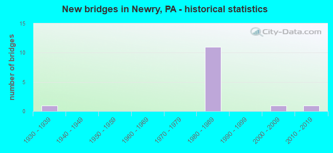
- New bridges - historical statistics
- 11930-1939
- 111980-1989
- 12000-2009
- 12010-2019

- Reconstructed bridges - Historical Statistics
- 11950-1959
- 01960-1969
- 01970-1979
- 01980-1989
- 01990-1999
- 52000-2009


- Bridge Condition - Deck
- 11.1%Very good
- 77.8%Good
- 11.1%Poor

- Bridge Condition - Superstructure
- 22.2%Very good
- 22.2%Good
- 33.3%Satisfactory
- 11.1%Fair
- 11.1%Poor

- Bridge Condition - Substructure
- 22.2%Very good
- 22.2%Good
- 44.4%Satisfactory
- 11.1%Fair

- Bridge Condition - Channel
- 20.0%Good
- 80.0%Satisfactory
Find on map >> Show street view
Structure Number: 5554, Location: .25 MI.S.OF CATFISH (Lat: 40.391450, Lng: -78.412497), Route carried "on" structure: State highway 36, Year Built: 1988, Status: Open, Structure Length: 3.14m (10.30ft), Average Daily Traffic: 6,269 (year 2022), Truck Traffic: 4%, Average Future Daily Traffic: 7,293 (year 2032), Design Load: HS 25 or greater, Features Intersected: POPLAR RUN
Minimum Vertical Clearance: 30+ m (98+ ft), Kilometerpoint: 15.170, Lanes on structure: 2, Owner: State Highway Agency, Approaching Roadway Width: 9.4m (30.8ft), Skew: 5 degrees, Material/Design: Prestressed concrete, Design/Construction: Box Beam or Girders - Single/Spread, Number Of Spans In Main Unit: 2, Length of Maximum Span: 15.2m (49.9ft), Curb or Sidewalk Widths: Left: 0.2m (0.7ft), Right: 0.2m (0.7ft), Curb-To-Curb Width: 10.4m (34.1ft), Out-to-Out Width: 11.1m (36.4ft)
Condition: Deck: Good, Superstructure: Good, Substructure: Good, Channel: Satisfactory, Operating Rating: 80.7 metric tons, Method Used To Determine Operating Rating: Load Factor (LF), Inventory Rating: 31.8 metric tons, Method Used To Determine Inventory Rating: Load Factor (LF), Structural Evaluation: Better than present minimum criteria, Deck Geometry: Meets minimum limits, Waterway Adequacy: Equal to present desirable criteria, Approach Roadway Alignment: Equal to present desirable criteria, Length Of Structure Improvement: 3.90m (12.80ft), Designated Inspection Frequency: Every 24 months, Inspection Date: April 2020, Deck Structure Type: Concrete Cast-file-Place, Wearing Surface/Protective System: Wearing Surface: Monolithic Concrete, Deck Protection: Epoxy Coated Reinforcing
Find on map >> Show street view
Structure Number: 5577, Location: 1 MI.S.OF NEWRY (Lat: 40.380489, Lng: -78.434172), Route carried "on" structure: Interstate 99, Year Built: 1987, Year Reconstructed: 2013, Status: Open, Structure Length: 6.10m (20.01ft), Average Daily Traffic: 10,207 (year 2021), Truck Traffic: 15%, Average Future Daily Traffic: 12,271 (year 2032), Design Load: HS 25 or greater, Features Intersected: SR 3013
Minimum Vertical Clearance: 30+ m (98+ ft), Kilometerpoint: 14.655, Lanes on structure: 2, Lanes under structure: 2, Base Highway Network: Yes, Owner: State Highway Agency, Approaching Roadway Width: 12.2m (40.0ft), Skew: 14 degrees, Material/Design: Prestressed concrete, Design/Construction: Box Beam or Girders - Multiple, Number Of Spans In Main Unit: 1, Number Of Approach Spans: 2, Length of Maximum Span: 28.0m (91.9ft), Curb or Sidewalk Widths: Left: 0.2m (0.7ft), Right: 0.2m (0.7ft), Curb-To-Curb Width: 12.8m (42.0ft), Out-to-Out Width: 13.9m (45.6ft)
Condition: Deck: Good, Superstructure: Satisfactory, Substructure: Satisfactory, Operating Rating: 84.4 metric tons, Method Used To Determine Operating Rating: Load Factor (LF), Inventory Rating: 39.9 metric tons, Method Used To Determine Inventory Rating: Load Factor (LF), Structural Evaluation: Equal to present minimum criteria, Deck Geometry: Equal to present desirable criteria, Underclear: Equal to present minimum criteria, Approach Roadway Alignment: Equal to present desirable criteria, Length Of Structure Improvement: 7.10m (23.29ft), Designated Inspection Frequency: Every 24 months, Inspection Date: July 2020, Deck Structure Type: Concrete Cast-file-Place, Wearing Surface/Protective System: Wearing Surface: Epoxy Overlay, Deck Protection: Epoxy Coated Reinforcing
Find on map >> Show street view
Structure Number: 5579, Location: .25 MI.S.OF NEWRY (Lat: 40.390564, Lng: -78.429153), Route carried "on" structure: Interstate 99, Year Built: 1987, Year Reconstructed: 2013, Status: Open, Structure Length: 7.92m (25.98ft), Average Daily Traffic: 10,207 (year 2021), Truck Traffic: 15%, Average Future Daily Traffic: 12,271 (year 2032), Design Load: HS 25 or greater, Features Intersected: POPLAR RUN
Minimum Vertical Clearance: 30+ m (98+ ft), Kilometerpoint: 15.463, Lanes on structure: 2, Base Highway Network: Yes, Owner: State Highway Agency, Approaching Roadway Width: 12.2m (40.0ft), Skew: 11 degrees, Material/Design: Prestressed concrete, Design/Construction: Stringer/Multi-beam, Number Of Spans In Main Unit: 3, Length of Maximum Span: 27.1m (88.9ft), Curb or Sidewalk Widths: Left: 0.2m (0.7ft), Right: 0.2m (0.7ft), Curb-To-Curb Width: 12.8m (42.0ft), Out-to-Out Width: 13.9m (45.6ft)
Condition: Deck: Good, Superstructure: Good, Substructure: Good, Channel: Satisfactory, Operating Rating: 83.5 metric tons, Method Used To Determine Operating Rating: Load Factor (LF), Inventory Rating: 39.9 metric tons, Method Used To Determine Inventory Rating: Load Factor (LF), Structural Evaluation: Better than present minimum criteria, Deck Geometry: Equal to present desirable criteria, Waterway Adequacy: Superior to present desirable criteria, Approach Roadway Alignment: Equal to present desirable criteria, Length Of Structure Improvement: 8.80m (28.87ft), Designated Inspection Frequency: Every 48 months, Inspection Date: August 2019, Deck Structure Type: Concrete Cast-file-Place, Wearing Surface/Protective System: Wearing Surface: Epoxy Overlay, Deck Protection: Epoxy Coated Reinforcing
Find on map >> Show street view
Structure Number: 5581, Location: NEWRY BOROUGH (Lat: 40.394100, Lng: -78.431072), Route carried "on" structure: Interstate 99, Year Built: 1987, Year Reconstructed: 2013, Status: Open, Structure Length: 4.21m (13.81ft), Average Daily Traffic: 10,207 (year 2021), Truck Traffic: 15%, Average Future Daily Traffic: 12,271 (year 2032), Design Load: HS 25 or greater, Features Intersected: T373 (CATFISH ROAD)
Minimum Vertical Clearance: 30+ m (98+ ft), Kilometerpoint: 16.235, Lanes on structure: 2, Lanes under structure: 2, Base Highway Network: Yes, Owner: State Highway Agency, Approaching Roadway Width: 11.6m (38.1ft), Skew: 10 degrees, Material/Design: Prestressed concrete, Design/Construction: Box Beam or Girders - Single/Spread, Number Of Spans In Main Unit: 3, Length of Maximum Span: 15.2m (49.9ft), Curb or Sidewalk Widths: Left: 0.2m (0.7ft), Right: 0.2m (0.7ft), Curb-To-Curb Width: 12.8m (42.0ft), Out-to-Out Width: 13.9m (45.6ft)
Condition: Deck: Good, Superstructure: Fair, Substructure: Satisfactory, Operating Rating: 68.0 metric tons, Method Used To Determine Operating Rating: Load Factor (LF), Inventory Rating: 39.9 metric tons, Method Used To Determine Inventory Rating: Load Factor (LF), Structural Evaluation: Somewhat better than minimum adequacy, Deck Geometry: Equal to present desirable criteria, Underclear: Superior to present desirable criteria, Approach Roadway Alignment: Equal to present desirable criteria, Length Of Structure Improvement: 5.10m (16.73ft), Designated Inspection Frequency: Every 24 months, Inspection Date: July 2020, Deck Structure Type: Concrete Cast-file-Place, Wearing Surface/Protective System: Wearing Surface: Epoxy Overlay, Deck Protection: Epoxy Coated Reinforcing
Find on map >> Show street view
Structure Number: 5582, Location: 1 MI.N.OF NEWRY (Lat: 40.407631, Lng: -78.434253), Route carried "on" structure: Interstate 99, Year Built: 1984, Year Reconstructed: 2013, Status: Open, Structure Length: 4.91m (16.11ft), Average Daily Traffic: 10,325 (year 2021), Truck Traffic: 15%, Average Future Daily Traffic: 12,358 (year 2032), Design Load: HS 20+Mod, Features Intersected: SR 2012
Minimum Vertical Clearance: 30+ m (98+ ft), Kilometerpoint: 17.846, Lanes on structure: 2, Lanes under structure: 2, Base Highway Network: Yes, Owner: State Highway Agency, Approaching Roadway Width: 12.2m (40.0ft), Skew: 12 degrees, Material/Design: Prestressed concrete, Design/Construction: Box Beam or Girders - Multiple, Number Of Spans In Main Unit: 3, Length of Maximum Span: 20.4m (66.9ft), Curb or Sidewalk Widths: Left: 0.2m (0.7ft), Right: 0.2m (0.7ft), Curb-To-Curb Width: 12.8m (42.0ft), Out-to-Out Width: 13.9m (45.6ft)
Condition: Deck: Good, Superstructure: Satisfactory, Substructure: Satisfactory, Operating Rating: 78.9 metric tons, Method Used To Determine Operating Rating: Load Factor (LF), Inventory Rating: 38.1 metric tons, Method Used To Determine Inventory Rating: Load Factor (LF), Structural Evaluation: Equal to present minimum criteria, Deck Geometry: Equal to present desirable criteria, Underclear: Equal to present minimum criteria, Approach Roadway Alignment: Equal to present desirable criteria, Length Of Structure Improvement: 5.70m (18.70ft), Designated Inspection Frequency: Every 24 months, Inspection Date: July 2020, Deck Structure Type: Concrete Cast-file-Place, Wearing Surface/Protective System: Wearing Surface: Epoxy Overlay, Deck Protection: Epoxy Coated Reinforcing
Find on map >> Show street view
Structure Number: 5583, Location: 1 MI.N.OF NEWRY (Lat: 40.407625, Lng: -78.434461), Route carried "on" structure: Interstate 99, Year Built: 1984, Year Reconstructed: 2012, Status: Open, Structure Length: 5.94m (19.49ft), Average Daily Traffic: 10,207 (year 2021), Truck Traffic: 15%, Average Future Daily Traffic: 12,271 (year 2032), Design Load: HS 20+Mod, Features Intersected: SR 2012
Minimum Vertical Clearance: 30+ m (98+ ft), Kilometerpoint: 17.844, Lanes on structure: 2, Lanes under structure: 2, Base Highway Network: Yes, Owner: State Highway Agency, Approaching Roadway Width: 12.2m (40.0ft), Skew: 12 degrees, Material/Design: Prestressed concrete, Design/Construction: Box Beam or Girders - Multiple, Number Of Spans In Main Unit: 3, Length of Maximum Span: 20.4m (66.9ft), Curb or Sidewalk Widths: Left: 0.2m (0.7ft), Right: 0.2m (0.7ft), Curb-To-Curb Width: 12.8m (42.0ft), Out-to-Out Width: 13.9m (45.6ft)
Condition: Deck: Good, Superstructure: Satisfactory, Substructure: Satisfactory, Operating Rating: 83.5 metric tons, Method Used To Determine Operating Rating: Load Factor (LF), Inventory Rating: 41.7 metric tons, Method Used To Determine Inventory Rating: Load Factor (LF), Structural Evaluation: Equal to present minimum criteria, Deck Geometry: Equal to present desirable criteria, Underclear: Superior to present desirable criteria, Approach Roadway Alignment: Equal to present desirable criteria, Length Of Structure Improvement: 6.90m (22.64ft), Designated Inspection Frequency: Every 48 months, Inspection Date: August 2018, Deck Structure Type: Concrete Cast-file-Place, Wearing Surface/Protective System: Wearing Surface: Epoxy Overlay, Deck Protection: Epoxy Coated Reinforcing
Find on map >> Show street view
Structure Number: 5904, Location: 1.5 MI.EAST OF NEWRY (Lat: 40.395419, Lng: -78.407881), Route carried "on" structure: City street , Year Built: 1937, Year Reconstructed: 1955, Status: Posted for load, Structure Length: 3.87m (12.70ft), Average Daily Traffic: 1,469 (year 2021), Truck Traffic: 1%, Average Future Daily Traffic: 1,836 (year 2041), Design Load: HS 20, Features Intersected: FRTOWN.BR.JUNIATA RIVER, Facility Carried by Structure: T375, Monastery RD
Minimum Vertical Clearance: 30+ m (98+ ft), Kilometerpoint: 0.000, Lanes on structure: 2, Owner: County Highway Agency, Approaching Roadway Width: 5.5m (18.0ft), Material/Design: Steel, Design/Construction: Stringer/Multi-beam, Number Of Spans In Main Unit: 2, Length of Maximum Span: 18.9m (62.0ft), Curb or Sidewalk Widths: Left: 0.2m (0.7ft), Right: 0.2m (0.7ft), Curb-To-Curb Width: 6.6m (21.7ft), Out-to-Out Width: 7.3m (24.0ft)
Condition: Deck: Poor, Superstructure: Poor, Substructure: Fair, Channel: Satisfactory, Operating Rating: 34.5 metric tons, Method Used To Determine Operating Rating: Load Factor (LF), Inventory Rating: 20.9 metric tons, Method Used To Determine Inventory Rating: Load Factor (LF), Structural Evaluation: Meets minimum limits, Deck Geometry: High priority of replacement, Waterway Adequacy: Better than present minimum criteria, Approach Roadway Alignment: Equal to present desirable criteria, Bridge Posting: Required (Relationship of Operating Rating to Maximum Legal Load: 10.0 - 19.9% below), Length Of Structure Improvement: 4.80m (15.75ft), Designated Inspection Frequency: Every 24 months, Other Special Inspection Frequency: Every 12 months, Inspection Date: September 2021, Other Special Inspection Date: September 2021, Bridge Improvement Cost: $118,000, Roadway Improvement Cost: $346,000, Total Project Cost: $1,587,000, Deck Structure Type: Open Grating
Find on map >> Show street view
Structure Number: 44154, Location: 1 MILE WEST OF NEWRY (Lat: 40.389694, Lng: -78.457125), Route carried "on" structure: State highway , Year Built: 2007, Status: Open, Structure Length: 2.50m (8.20ft), Average Daily Traffic: 1,234 (year 2020), Truck Traffic: 7%, Average Future Daily Traffic: 2,650 (year 2032), Design Load: HL 93, Features Intersected: POPLAR RUN, Facility Carried by Structure: SR 3003
Minimum Vertical Clearance: 30+ m (98+ ft), Kilometerpoint: 14.682, Lanes on structure: 2, Owner: State Highway Agency, Approaching Roadway Width: 9.1m (29.9ft), Skew: 4 degrees, Material/Design: Prestressed concrete, Design/Construction: Box Beam or Girders - Single/Spread, Number Of Spans In Main Unit: 1, Length of Maximum Span: 24.4m (80.1ft), Curb or Sidewalk Widths: Left: 0.1m (0.3ft), Right: 0.1m (0.3ft), Curb-To-Curb Width: 9.2m (30.2ft), Out-to-Out Width: 10.2m (33.5ft)
Condition: Deck: Good, Superstructure: Very good, Substructure: Very good, Channel: Good, Operating Rating: 66.2 metric tons, Method Used To Determine Operating Rating: Load Factor (LF), Inventory Rating: 29.0 metric tons, Method Used To Determine Inventory Rating: Load Factor (LF), Structural Evaluation: Better than present minimum criteria, Deck Geometry: Somewhat better than minimum adequacy, Waterway Adequacy: Equal to present desirable criteria, Approach Roadway Alignment: Equal to present desirable criteria, Designated Inspection Frequency: Every 24 months, Inspection Date: May 2020, Deck Structure Type: Concrete Cast-file-Place, Wearing Surface/Protective System: Wearing Surface: Monolithic Concrete, Deck Protection: Galvanized Reinforcing
Find on map >> Show street view
Structure Number: 55782, Location: NEWRY BORO LINE (Lat: 40.389972, Lng: -78.435389), Route carried "on" structure: US 220B, Year Built: 2018, Status: Open, Structure Length: 1.80m (5.91ft), Average Daily Traffic: 8,565 (year 2020), Truck Traffic: 17%, Average Future Daily Traffic: 10,000 (year 2037), Design Load: HL 93, Features Intersected: POPLAR RUN, Facility Carried by Structure: SR 3013
Minimum Vertical Clearance: 30+ m (98+ ft), Kilometerpoint: 14.359, Lanes on structure: 2, Owner: State Highway Agency, Approaching Roadway Width: 8.8m (28.9ft), Material/Design: Steel, Design/Construction: Stringer/Multi-beam, Number Of Spans In Main Unit: 1, Length of Maximum Span: 16.8m (55.1ft), Curb or Sidewalk Widths: Left: 2.3m (7.5ft), Right: 0.0m, Curb-To-Curb Width: 9.1m (29.9ft), Out-to-Out Width: 12.4m (40.7ft)
Condition: Deck: Very good, Superstructure: Very good, Substructure: Very good, Channel: Satisfactory, Operating Rating: 52.5 metric tons, Method Used To Determine Operating Rating: Assigned ratings based on Load and Resistance Factor Design (LRFD) reported by rating factor (RF) using HL93 loadings, Inventory Rating: 40.5 metric tons, Method Used To Determine Inventory Rating: Assigned ratings based on Load and Resistance Factor Design (LRFD) reported by rating factor (RF) using HL93 loadings, Structural Evaluation: Equal to present desirable criteria, Deck Geometry: High priority of corrective action, Waterway Adequacy: Equal to present minimum criteria, Approach Roadway Alignment: Equal to present desirable criteria, Length Of Structure Improvement: 1.80m (5.91ft), Designated Inspection Frequency: Every 24 months, Inspection Date: September 2020, Deck Structure Type: Concrete Cast-file-Place, Wearing Surface/Protective System: Wearing Surface: Epoxy Overlay, Deck Protection: Epoxy Coated Reinforcing
Find on map >> Show street view
Structure Number: 5577, Location: 1 MI.S.OF NEWRY (Lat: 40.380489, Lng: -78.434172), Route carried "under" structure: US 220B, Year Built: 1987, Structure Length: 0. m, Average Daily Traffic: 8,565 (year 2020), Truck Traffic: 17%, Features Intersected: SR 3013, Facility Carried by Structure: I-99 / US 220 SBL
Minimum Vertical Clearance: 4.52m (14.83ft), Kilometerpoint: 13.266, Lanes on structure: 2, Lanes under structure: 2, Material/Design: Prestressed concrete, Design/Construction: Box Beam or Girders - Multiple, Length of Maximum Span: 28.0m (91.9ft)
Find on map >> Show street view
Structure Number: 558, Location: NEWRY BOROUGH (Lat: 40.394086, Lng: -78.430822), Route carried "under" structure: City street , Year Built: 1987, Structure Length: 0. m, Average Daily Traffic: 25 (year 1993), Features Intersected: T373 (CATFISH ROAD), Facility Carried by Structure: I-99 / US 220 NBL
Minimum Vertical Clearance: 6.38m (20.93ft), Kilometerpoint: 0.000, Lanes on structure: 2, Lanes under structure: 2, Material/Design: Prestressed concrete, Design/Construction: Box Beam or Girders - Single/Spread, Length of Maximum Span: 15.2m (49.9ft)
Find on map >> Show street view
Structure Number: 5581, Location: NEWRY BOROUGH (Lat: 40.394100, Lng: -78.431072), Route carried "under" structure: City street , Year Built: 1987, Structure Length: 0. m, Average Daily Traffic: 25 (year 1993), Features Intersected: T373 (CATFISH ROAD), Facility Carried by Structure: I-99 / US 220 SBL
Minimum Vertical Clearance: 6.78m (22.24ft), Kilometerpoint: 0.000, Lanes on structure: 2, Lanes under structure: 2, Material/Design: Prestressed concrete, Design/Construction: Box Beam or Girders - Single/Spread, Length of Maximum Span: 15.2m (49.9ft)
Find on map >> Show street view
Structure Number: 5582, Location: 1 MI.N.OF NEWRY (Lat: 40.407631, Lng: -78.434253), Route carried "under" structure: State highway , Year Built: 1984, Structure Length: 0. m, Average Daily Traffic: 1,096 (year 2020), Truck Traffic: 1%, Features Intersected: SR 2012, Facility Carried by Structure: I-99 / US 220 NBL
Minimum Vertical Clearance: 4.57m (14.99ft), Kilometerpoint: 0.000, Lanes on structure: 2, Lanes under structure: 2, Material/Design: Prestressed concrete, Design/Construction: Box Beam or Girders - Multiple, Length of Maximum Span: 20.4m (66.9ft)
Find on map >> Show street view
Structure Number: 5583, Location: 1 MI.N.OF NEWRY (Lat: 40.407625, Lng: -78.434461), Route carried "under" structure: State highway , Year Built: 1984, Structure Length: 0. m, Average Daily Traffic: 1,096 (year 2020), Truck Traffic: 1%, Features Intersected: SR 2012, Facility Carried by Structure: I-99 / US 220 SBL
Minimum Vertical Clearance: 7.62m (25.00ft), Kilometerpoint: 0.000, Lanes on structure: 2, Lanes under structure: 2, Material/Design: Prestressed concrete, Design/Construction: Box Beam or Girders - Multiple, Length of Maximum Span: 20.4m (66.9ft)