Bridge Statistics for Newport, Pennsylvania (PA)
Condition, Traffic, Stress, Structural Evaluation, Project Costs
- National Bridge Inventory (NBI) Statistics
- 18Number of bridges
- 177ft / 53.6mTotal length
- $7,050,000Total costs
- 83,080Total average daily traffic
- 13,587Total average daily truck traffic
- National Bridge Inventory (NBI) Registered Bridges for Newport
- No street view available for this location
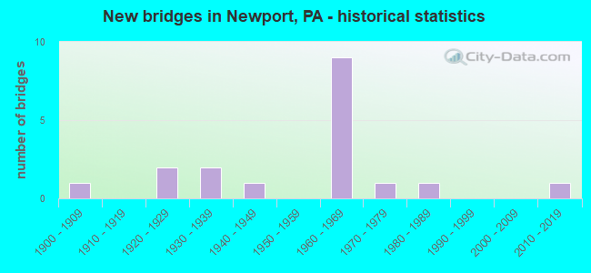
- New bridges - historical statistics
- 11900-1909
- 21920-1929
- 21930-1939
- 11940-1949
- 91960-1969
- 11970-1979
- 11980-1989
- 12010-2019

- Reconstructed bridges - Historical Statistics
- 11940-1949
- 01950-1959
- 11960-1969
- 01970-1979
- 21980-1989
- 01990-1999
- 02000-2009
- 12010-2019


- Bridge Condition - Deck
- 9.1%Excellent
- 27.3%Good
- 36.4%Satisfactory
- 18.2%Fair
- 9.1%Poor

- Bridge Condition - Superstructure
- 7.7%Excellent
- 15.4%Very good
- 15.4%Good
- 15.4%Satisfactory
- 30.8%Fair
- 15.4%Poor

- Bridge Condition - Substructure
- 7.7%Very good
- 15.4%Good
- 23.1%Satisfactory
- 53.8%Fair

- Bridge Condition - Channel
- 10.0%Very good
- 20.0%Good
- 20.0%Satisfactory
- 50.0%Fair
Find on map >> Show street view
Structure Number: 2948, Location: 2.4MI SE OF MILLERSTOWN (Lat: 40.516111, Lng: -77.128175), Route carried "on" structure: US 22, Year Built: 1966, Status: Open, Structure Length: 0.98m (3.22ft), Average Daily Traffic: 7,303 (year 2020), Truck Traffic: 23%, Average Future Daily Traffic: 13,003 (year 2032), Design Load: HS 20, Features Intersected: OWL HOLLOW RD.
Minimum Vertical Clearance: 30+ m (98+ ft), Kilometerpoint: 6.622, Lanes on structure: 2, Lanes under structure: 2, Base Highway Network: Yes, Owner: State Highway Agency, Approaching Roadway Width: 11.6m (38.1ft), Skew: 10 degrees, Material/Design: Prestressed concrete, Design/Construction: Box Beam or Girders - Single/Spread, Number Of Spans In Main Unit: 1, Length of Maximum Span: 9.4m (30.8ft), Curb or Sidewalk Widths: Left: 0.2m (0.7ft), Right: 0.2m (0.7ft), Curb-To-Curb Width: 12.2m (40.0ft), Out-to-Out Width: 13.9m (45.6ft)
Condition: Deck: Fair, Superstructure: Very good, Substructure: Satisfactory, Operating Rating: 50.8 metric tons, Method Used To Determine Operating Rating: Load Factor (LF), Inventory Rating: 21.8 metric tons, Method Used To Determine Inventory Rating: Load Factor (LF), Structural Evaluation: Somewhat better than minimum adequacy, Deck Geometry: Better than present minimum criteria, Underclear: Equal to present minimum criteria, Approach Roadway Alignment: Equal to present desirable criteria, Length Of Structure Improvement: 1.60m (5.25ft), Designated Inspection Frequency: Every 24 months, Inspection Date: March 2021, Bridge Improvement Cost: $14,000, Roadway Improvement Cost: $40,000, Total Project Cost: $186,000, Deck Structure Type: Concrete Cast-file-Place, Wearing Surface/Protective System: Wearing Surface: Bituminous, Membrane: Preformed Fabric
Find on map >> Show street view
Structure Number: 29481, Location: 2.5MI SE OF MILLERSTOWN (Lat: 40.515192, Lng: -77.127831), Route carried "on" structure: US 22, Year Built: 1965, Status: Open, Structure Length: 0.91m (2.99ft), Average Daily Traffic: 14,395 (year 2020), Truck Traffic: 24%, Average Future Daily Traffic: 27,053 (year 2032), Design Load: HS 20, Features Intersected: WILD CAT RUN
Minimum Vertical Clearance: 30+ m (98+ ft), Kilometerpoint: 6.622, Lanes on structure: 4, Base Highway Network: Yes, Owner: State Highway Agency, Approaching Roadway Width: 43.0m (141.1ft), Skew: 20 degrees, Material/Design: Concrete, Design/Construction: Culvert, Number Of Spans In Main Unit: 1, Length of Maximum Span: 7.9m (25.9ft)
Condition: Channel: Good, Culverts: Satisfactory, Operating Rating: 75.3 metric tons, Method Used To Determine Operating Rating: Field evaluation and documented engineering judgment, Inventory Rating: 44.5 metric tons, Method Used To Determine Inventory Rating: Field evaluation and documented engineering judgment, Structural Evaluation: Equal to present minimum criteria, Waterway Adequacy: Superior to present desirable criteria, Approach Roadway Alignment: Equal to present desirable criteria, Length Of Structure Improvement: 1.40m (4.59ft), Designated Inspection Frequency: Every 48 months, Inspection Date: May 2019
Find on map >> Show street view
Structure Number: 29482, Location: 2.4MI SE OF MILLERSTOWN (Lat: 40.516219, Lng: -77.127878), Route carried "on" structure: US 22, Year Built: 1966, Status: Open, Structure Length: 0.98m (3.22ft), Average Daily Traffic: 7,092 (year 2020), Truck Traffic: 25%, Average Future Daily Traffic: 14,050 (year 2032), Design Load: HS 20, Features Intersected: OWL HOLLOW RD.
Minimum Vertical Clearance: 30+ m (98+ ft), Kilometerpoint: 6.643, Lanes on structure: 2, Lanes under structure: 2, Base Highway Network: Yes, Owner: State Highway Agency, Approaching Roadway Width: 11.6m (38.1ft), Skew: 10 degrees, Material/Design: Prestressed concrete, Design/Construction: Box Beam or Girders - Single/Spread, Number Of Spans In Main Unit: 1, Length of Maximum Span: 9.4m (30.8ft), Curb-To-Curb Width: 12.2m (40.0ft), Out-to-Out Width: 13.9m (45.6ft)
Condition: Deck: Satisfactory, Superstructure: Good, Substructure: Satisfactory, Operating Rating: 50.8 metric tons, Method Used To Determine Operating Rating: Load Factor (LF), Inventory Rating: 21.8 metric tons, Method Used To Determine Inventory Rating: Load Factor (LF), Structural Evaluation: Somewhat better than minimum adequacy, Deck Geometry: Better than present minimum criteria, Underclear: Equal to present minimum criteria, Approach Roadway Alignment: Equal to present desirable criteria, Length Of Structure Improvement: 1.60m (5.25ft), Designated Inspection Frequency: Every 24 months, Inspection Date: March 2021, Deck Structure Type: Concrete Cast-file-Place, Wearing Surface/Protective System: Wearing Surface: Bituminous, Membrane: Preformed Fabric
Find on map >> Show street view
Structure Number: 29483, Location: 2 MI.NE OF NEWPORT BORO (Lat: 40.494722, Lng: -77.108008), Route carried "on" structure: US 22, Year Built: 1966, Status: Open, Structure Length: 5.03m (16.50ft), Average Daily Traffic: 8,657 (year 2020), Truck Traffic: 21%, Average Future Daily Traffic: 12,082 (year 2032), Design Load: HS 20, Features Intersected: PA 34; SR 0034
Minimum Vertical Clearance: 30+ m (98+ ft), Kilometerpoint: 10.295, Lanes on structure: 2, Lanes under structure: 2, Base Highway Network: Yes, Owner: State Highway Agency, Approaching Roadway Width: 11.6m (38.1ft), Skew: 14 degrees, Material/Design: Prestressed concrete, Design/Construction: Box Beam or Girders - Single/Spread, Number Of Spans In Main Unit: 3, Length of Maximum Span: 17.7m (58.1ft), Curb or Sidewalk Widths: Left: 0.2m (0.7ft), Right: 0.2m (0.7ft), Curb-To-Curb Width: 12.2m (40.0ft), Out-to-Out Width: 13.9m (45.6ft)
Condition: Deck: Satisfactory, Superstructure: Fair, Substructure: Fair, Operating Rating: 78.0 metric tons, Method Used To Determine Operating Rating: Load Factor (LF), Inventory Rating: 30.8 metric tons, Method Used To Determine Inventory Rating: Load Factor (LF), Structural Evaluation: Somewhat better than minimum adequacy, Deck Geometry: Better than present minimum criteria, Underclear: Superior to present desirable criteria, Approach Roadway Alignment: Equal to present desirable criteria, Length Of Structure Improvement: 5.40m (17.72ft), Designated Inspection Frequency: Every 24 months, Inspection Date: May 2021, Bridge Improvement Cost: $57,000, Roadway Improvement Cost: $167,000, Total Project Cost: $767,000, Deck Structure Type: Concrete Cast-file-Place, Wearing Surface/Protective System: Wearing Surface: Bituminous, Membrane: Preformed Fabric
Find on map >> Show street view
Structure Number: 29484, Location: 2 MI.NE OF NEWPORT BORO (Lat: 40.494933, Lng: -77.107889), Route carried "on" structure: US 22, Year Built: 1966, Status: Open, Structure Length: 4.48m (14.70ft), Average Daily Traffic: 8,645 (year 2020), Truck Traffic: 21%, Average Future Daily Traffic: 12,625 (year 2032), Design Load: HS 20, Features Intersected: PA 34; SR 0034
Minimum Vertical Clearance: 30+ m (98+ ft), Kilometerpoint: 10.305, Lanes on structure: 2, Lanes under structure: 2, Base Highway Network: Yes, Owner: State Highway Agency, Approaching Roadway Width: 11.6m (38.1ft), Skew: 14 degrees, Material/Design: Prestressed concrete, Design/Construction: Box Beam or Girders - Single/Spread, Number Of Spans In Main Unit: 3, Length of Maximum Span: 17.7m (58.1ft), Curb or Sidewalk Widths: Left: 0.2m (0.7ft), Right: 0.2m (0.7ft), Curb-To-Curb Width: 12.2m (40.0ft), Out-to-Out Width: 13.9m (45.6ft)
Condition: Deck: Satisfactory, Superstructure: Fair, Substructure: Fair, Operating Rating: 70.8 metric tons, Method Used To Determine Operating Rating: Load Factor (LF), Inventory Rating: 26.3 metric tons, Method Used To Determine Inventory Rating: Load Factor (LF), Structural Evaluation: Somewhat better than minimum adequacy, Deck Geometry: Better than present minimum criteria, Underclear: Equal to present minimum criteria, Approach Roadway Alignment: Equal to present desirable criteria, Length Of Structure Improvement: 6.00m (19.69ft), Designated Inspection Frequency: Every 24 months, Inspection Date: May 2021, Bridge Improvement Cost: $43,000, Roadway Improvement Cost: $127,000, Total Project Cost: $582,000, Deck Structure Type: Concrete Cast-file-Place, Wearing Surface/Protective System: Wearing Surface: Bituminous, Membrane: Preformed Fabric
Find on map >> Show street view
Structure Number: 29507, Location: NEWPORT BORO (Lat: 40.474167, Lng: -77.127778), Route carried "on" structure: State highway 34, Year Built: 1929, Year Reconstructed: 1968, Status: Open, Structure Length: 2.13m (6.99ft), Average Daily Traffic: 6,655 (year 2020), Truck Traffic: 11%, Average Future Daily Traffic: 8,685 (year 2032), Features Intersected: LITTLE BUFFALO CREEK
Minimum Vertical Clearance: 30+ m (98+ ft), Kilometerpoint: 27.856, Lanes on structure: 2, Base Highway Network: Yes, Owner: State Highway Agency, Approaching Roadway Width: 7.6m (24.9ft), Material/Design: Masonry, Design/Construction: Arch - Deck, Number Of Spans In Main Unit: 3, Length of Maximum Span: 7.0m (23.0ft), Curb or Sidewalk Widths: Left: 0.0m, Right: 1.2m (3.9ft), Curb-To-Curb Width: 6.6m (21.7ft), Out-to-Out Width: 7.9m (25.9ft)
Condition: Superstructure: Poor, Substructure: Fair, Channel: Satisfactory, Operating Rating: 49.0 metric tons, Method Used To Determine Operating Rating: Field evaluation and documented engineering judgment, Inventory Rating: 32.7 metric tons, Method Used To Determine Inventory Rating: Field evaluation and documented engineering judgment, Structural Evaluation: Meets minimum limits, Deck Geometry: High priority of replacement, Waterway Adequacy: Equal to present desirable criteria, Approach Roadway Alignment: Equal to present desirable criteria, Length Of Structure Improvement: 2.10m (6.89ft), Designated Inspection Frequency: Every 24 months, Other Special Inspection Frequency: Every 12 months, Inspection Date: April 2020, Other Special Inspection Date: April 2021, Bridge Improvement Cost: $32,000, Roadway Improvement Cost: $100,000, Total Project Cost: $437,000
Find on map >> Show street view
Structure Number: 29509, Location: EAST OF NEWPORT BORO (Lat: 40.478997, Lng: -77.128200), Route carried "on" structure: State highway 34, Year Built: 1934, Status: Open, Structure Length: 21.06m (69.09ft), Average Daily Traffic: 10,075 (year 2022), Truck Traffic: 7%, Average Future Daily Traffic: 12,772 (year 2032), Design Load: H 20, Features Intersected: Juniata River
Minimum Vertical Clearance: 4.42m (14.50ft), Kilometerpoint: 28.799, Lanes on structure: 2, Base Highway Network: Yes, Owner: State Highway Agency, Approaching Roadway Width: 7.0m (23.0ft), Material/Design: Steel, Design/Construction: Truss - Thru, Number Of Spans In Main Unit: 4, Length of Maximum Span: 52.4m (171.9ft), Curb or Sidewalk Widths: Left: 0.2m (0.7ft), Right: 2.1m (6.9ft), Curb-To-Curb Width: 7.0m (23.0ft), Out-to-Out Width: 9.9m (32.5ft)
Condition: Deck: Fair, Superstructure: Fair, Substructure: Fair, Channel: Fair, Operating Rating: 42.6 metric tons, Method Used To Determine Operating Rating: Load Factor (LF), Inventory Rating: 25.4 metric tons, Method Used To Determine Inventory Rating: Load Factor (LF), Structural Evaluation: Somewhat better than minimum adequacy, Deck Geometry: High priority of replacement, Waterway Adequacy: Superior to present desirable criteria, Approach Roadway Alignment: Equal to present desirable criteria, Length Of Structure Improvement: 21.70m (71.19ft), Designated Inspection Frequency: Every 24 months, Critical Feature Inspection Frequency: Every 24 months, Underwater Inspection Frequency: Every 60 months, Inspection Date: April 2021, Critical Feature Inspection Date: April 2021, Underwater Inspection Date: August 2020, Bridge Improvement Cost: $313,000, Roadway Improvement Cost: $922,000, Total Project Cost: $4,227,000, Deck Structure Type: Open Grating
Find on map >> Show street view
Structure Number: 29556, Location: WILA (Lat: 40.482225, Lng: -77.173992), Route carried "on" structure: State highway 849, Year Built: 1989, Status: Open, Structure Length: 5.03m (16.50ft), Average Daily Traffic: 839 (year 2020), Truck Traffic: 9%, Average Future Daily Traffic: 707 (year 2032), Design Load: HS 25 or greater, Features Intersected: BIG BUFFALO CREEK
Minimum Vertical Clearance: 30+ m (98+ ft), Kilometerpoint: 16.589, Lanes on structure: 2, Owner: State Highway Agency, Approaching Roadway Width: 9.1m (29.9ft), Skew: 3 degrees, Material/Design: Prestressed concrete, Design/Construction: Box Beam or Girders - Single/Spread, Number Of Spans In Main Unit: 3, Length of Maximum Span: 16.2m (53.1ft), Curb or Sidewalk Widths: Left: 0.2m (0.7ft), Right: 0.2m (0.7ft), Curb-To-Curb Width: 9.1m (29.9ft), Out-to-Out Width: 9.9m (32.5ft)
Condition: Deck: Good, Superstructure: Very good, Substructure: Good, Channel: Fair, Operating Rating: 76.2 metric tons, Method Used To Determine Operating Rating: Load Factor (LF), Inventory Rating: 37.2 metric tons, Method Used To Determine Inventory Rating: Load Factor (LF), Structural Evaluation: Better than present minimum criteria, Deck Geometry: Equal to present minimum criteria, Waterway Adequacy: Equal to present desirable criteria, Approach Roadway Alignment: Equal to present minimum criteria, Length Of Structure Improvement: 6.00m (19.69ft), Designated Inspection Frequency: Every 24 months, Inspection Date: March 2021, Deck Structure Type: Concrete Cast-file-Place, Wearing Surface/Protective System: Wearing Surface: Monolithic Concrete, Deck Protection: Epoxy Coated Reinforcing
Find on map >> Show street view
Structure Number: 29622, Location: 1 MI NORTH OF NEWPORT (Lat: 40.494192, Lng: -77.138656), Route carried "on" structure: State highway , Year Built: 1938, Year Reconstructed: 1948, Status: Posted for load, Structure Length: 2.65m (8.69ft), Average Daily Traffic: 143 (year 2021), Truck Traffic: 1%, Average Future Daily Traffic: 251 (year 2032), Design Load: H 20, Features Intersected: BUFFALO CREEK, Facility Carried by Structure: SR 1024
Minimum Vertical Clearance: 30+ m (98+ ft), Kilometerpoint: 5.900, Lanes on structure: 2, Owner: State Highway Agency, Approaching Roadway Width: 5.5m (18.0ft), Skew: 4 degrees, Material/Design: Steel, Design/Construction: Stringer/Multi-beam, Number Of Spans In Main Unit: 2, Length of Maximum Span: 12.2m (40.0ft), Curb-To-Curb Width: 7.4m (24.3ft), Out-to-Out Width: 7.9m (25.9ft)
Condition: Deck: Poor, Superstructure: Poor, Substructure: Fair, Channel: Satisfactory, Operating Rating: 33.6 metric tons, Method Used To Determine Operating Rating: Load Factor (LF), Inventory Rating: 20.0 metric tons, Method Used To Determine Inventory Rating: Load Factor (LF), Structural Evaluation: Meets minimum limits, Deck Geometry: Somewhat better than minimum adequacy, Waterway Adequacy: Superior to present desirable criteria, Approach Roadway Alignment: Somewhat better than minimum adequacy, Bridge Posting: Required (Relationship of Operating Rating to Maximum Legal Load: 20.0 - 29.9% below), Length Of Structure Improvement: 2.60m (8.53ft), Designated Inspection Frequency: Every 24 months, Other Special Inspection Frequency: Every 12 months, Inspection Date: May 2020, Other Special Inspection Date: November 2020, Bridge Improvement Cost: $39,000, Roadway Improvement Cost: $115,000, Total Project Cost: $527,000, Deck Structure Type: Concrete Cast-file-Place, Wearing Surface/Protective System: Wearing Surface: Bituminous, Membrane: Preformed Fabric
Find on map >> Show street view
Structure Number: 29701, Location: 1 MI SW OF NEWPORT (Lat: 40.464717, Lng: -77.137903), Route carried "on" structure: State highway , Year Built: 1940, Year Reconstructed: 1989, Status: Open, Structure Length: 1.40m (4.59ft), Average Daily Traffic: 827 (year 2022), Truck Traffic: 3%, Average Future Daily Traffic: 1,243 (year 2032), Design Load: HS 25 or greater, Features Intersected: LITTLE BUFFALO CREEK, Facility Carried by Structure: SR 4010
Minimum Vertical Clearance: 30+ m (98+ ft), Kilometerpoint: 18.163, Lanes on structure: 2, Owner: State Highway Agency, Approaching Roadway Width: 7.3m (24.0ft), Skew: 3 degrees, Material/Design: Steel, Design/Construction: Stringer/Multi-beam, Number Of Spans In Main Unit: 1, Length of Maximum Span: 12.8m (42.0ft), Curb or Sidewalk Widths: Left: 0.2m (0.7ft), Right: 0.2m (0.7ft), Curb-To-Curb Width: 7.3m (24.0ft), Out-to-Out Width: 8.4m (27.6ft)
Condition: Deck: Satisfactory, Superstructure: Satisfactory, Substructure: Fair, Channel: Good, Operating Rating: 78.9 metric tons, Method Used To Determine Operating Rating: Load Factor (LF), Inventory Rating: 47.2 metric tons, Method Used To Determine Inventory Rating: Load Factor (LF), Structural Evaluation: Somewhat better than minimum adequacy, Deck Geometry: Meets minimum limits, Waterway Adequacy: Better than present minimum criteria, Approach Roadway Alignment: Equal to present desirable criteria, Length Of Structure Improvement: 2.00m (6.56ft), Designated Inspection Frequency: Every 24 months, Inspection Date: April 2021, Deck Structure Type: Concrete Cast-file-Place, Wearing Surface/Protective System: Wearing Surface: Monolithic Concrete, Deck Protection: Epoxy Coated Reinforcing
Find on map >> Show street view
Structure Number: 29724, Location: NWPRT OLVR/LIT.BUFFALO CR (Lat: 40.475189, Lng: -77.128658), Route carried "on" structure: City street , Year Built: 1920, Status: Open, Structure Length: 1.22m (4.00ft), Average Daily Traffic: 200 (year 2019), Truck Traffic: 3%, Average Future Daily Traffic: 1,050 (year 2039), Features Intersected: LITTLE BUFFALO CREEK, Facility Carried by Structure: BLOOMFIELD AVENUE
Minimum Vertical Clearance: 30+ m (98+ ft), Kilometerpoint: 0.000, Lanes on structure: 2, Owner: Town or Township Highway Agency, Approaching Roadway Width: 6.7m (22.0ft), Material/Design: Masonry, Design/Construction: Arch - Deck, Number Of Spans In Main Unit: 1, Length of Maximum Span: 12.2m (40.0ft), Curb-To-Curb Width: 6.7m (22.0ft), Out-to-Out Width: 7.9m (25.9ft)
Condition: Superstructure: Fair, Substructure: Fair, Channel: Fair, Operating Rating: 49.0 metric tons, Method Used To Determine Operating Rating: Field evaluation and documented engineering judgment, Inventory Rating: 32.7 metric tons, Method Used To Determine Inventory Rating: Field evaluation and documented engineering judgment, Structural Evaluation: Somewhat better than minimum adequacy, Deck Geometry: Meets minimum limits, Waterway Adequacy: Equal to present desirable criteria, Approach Roadway Alignment: Equal to present desirable criteria, Length Of Structure Improvement: 1.40m (4.59ft), Designated Inspection Frequency: Every 24 months, Other Special Inspection Frequency: Every 12 months, Inspection Date: April 2021, Other Special Inspection Date: April 2021, Bridge Improvement Cost: $8,000, Roadway Improvement Cost: $25,000, Total Project Cost: $113,000
Find on map >> Show street view
Structure Number: 29725, Location: 1.5 NW NEWPORT/B.BUFFALO (Lat: 40.489494, Lng: -77.158150), Route carried "on" structure: City street , Year Built: 1900, Year Reconstructed: 1994, Status: Posted for load, Structure Length: 3.81m (12.50ft), Average Daily Traffic: 25 (year 2021), Truck Traffic: 1%, Average Future Daily Traffic: 125 (year 2041), Features Intersected: BIG BUFFALO CREEK, Facility Carried by Structure: FAIRGROUND RD
Minimum Vertical Clearance: 30+ m (98+ ft), Kilometerpoint: 0.000, Lanes on structure: 1, Owner: County Highway Agency, Approaching Roadway Width: 3.7m (12.1ft), Material/Design: Steel, Design/Construction: Stringer/Multi-beam, Number Of Spans In Main Unit: 2, Length of Maximum Span: 17.1m (56.1ft), Curb-To-Curb Width: 3.9m (12.8ft), Out-to-Out Width: 4.4m (14.4ft)
Condition: Deck: Good, Superstructure: Satisfactory, Substructure: Satisfactory, Channel: Fair, Operating Rating: 22.7 metric tons, Method Used To Determine Operating Rating: Load Factor (LF), Inventory Rating: 13.6 metric tons, Method Used To Determine Inventory Rating: Load Factor (LF), Structural Evaluation: Meets minimum limits, Deck Geometry: High priority of corrective action, Waterway Adequacy: Better than present minimum criteria, Approach Roadway Alignment: Meets minimum limits, Bridge Posting: Required (Relationship of Operating Rating to Maximum Legal Load: > 39.9% below), Length Of Structure Improvement: 4.40m (14.44ft), Designated Inspection Frequency: Every 24 months, Critical Feature Inspection Frequency: Every 12 months, Other Special Inspection Frequency: Every 12 months, Inspection Date: November 2019, Critical Feature Inspection Date: November 2020, Other Special Inspection Date: November 2020, Bridge Improvement Cost: $16,000, Roadway Improvement Cost: $61,000, Total Project Cost: $211,000, Deck Structure Type: Wood or Timber, Wearing Surface/Protective System: Wearing Surface: Wood or Timber
Find on map >> Show street view
Structure Number: 33079, Location: VILLAGE OF MARSHLANDS (Lat: 41.712119, Lng: -77.578503), Route carried "on" structure: State highway , Year Built: 1974, Year Reconstructed: 2015, Status: Open, Structure Length: 1.55m (5.09ft), Average Daily Traffic: 161 (year 2021), Truck Traffic: 9%, Average Future Daily Traffic: 373 (year 2032), Design Load: HS 20, Features Intersected: ELK RUN, Facility Carried by Structure: SR 3001
Minimum Vertical Clearance: 30+ m (98+ ft), Kilometerpoint: 1.967, Lanes on structure: 2, Owner: State Highway Agency, Approaching Roadway Width: 5.8m (19.0ft), Material/Design: Prestressed concrete, Design/Construction: Box Beam or Girders - Multiple, Number Of Spans In Main Unit: 1, Length of Maximum Span: 14.6m (47.9ft), Curb or Sidewalk Widths: Left: 0.2m (0.7ft), Right: 0.2m (0.7ft), Curb-To-Curb Width: 11.0m (36.1ft), Out-to-Out Width: 12.2m (40.0ft)
Condition: Deck: Good, Superstructure: Good, Substructure: Good, Channel: Fair, Operating Rating: 96.2 metric tons, Method Used To Determine Operating Rating: Load Factor (LF), Inventory Rating: 37.2 metric tons, Method Used To Determine Inventory Rating: Load Factor (LF), Structural Evaluation: Better than present minimum criteria, Deck Geometry: Equal to present desirable criteria, Waterway Adequacy: Better than present minimum criteria, Approach Roadway Alignment: Equal to present desirable criteria, Length Of Structure Improvement: 1.60m (5.25ft), Designated Inspection Frequency: Every 24 months, Inspection Date: September 2020, Wearing Surface/Protective System: Wearing Surface: Monolithic Concrete, Deck Protection: Epoxy Coated Reinforcing
Find on map >> Show street view
Structure Number: 53678, Location: 2 MI.S. OF MILLERSTOWN (Lat: 40.514347, Lng: -77.129719), Route carried "on" structure: State highway , Year Built: 2016, Status: Open, Structure Length: 2.35m (7.71ft), Average Daily Traffic: 3,605 (year 2021), Truck Traffic: 5%, Average Future Daily Traffic: 3,450 (year 2037), Design Load: HL 93, Features Intersected: Wildcat Run, Facility Carried by Structure: Juniata Parkway
Minimum Vertical Clearance: 30+ m (98+ ft), Kilometerpoint: 12.484, Lanes on structure: 2, Owner: State Highway Agency, Maintenance Responsibility: Private, Approaching Roadway Width: 9.8m (32.2ft), Skew: 4 degrees, Material/Design: Prestressed concrete, Design/Construction: Box Beam or Girders - Single/Spread, Number Of Spans In Main Unit: 1, Length of Maximum Span: 21.6m (70.9ft), Curb-To-Curb Width: 9.8m (32.2ft), Out-to-Out Width: 10.4m (34.1ft)
Condition: Deck: Excellent, Superstructure: Excellent, Substructure: Very good, Channel: Very good, Operating Rating: 42.4 metric tons, Method Used To Determine Operating Rating: Assigned ratings based on Load and Resistance Factor Design (LRFD) reported by rating factor (RF) using HL93 loadings, Inventory Rating: 32.7 metric tons, Method Used To Determine Inventory Rating: Assigned ratings based on Load and Resistance Factor Design (LRFD) reported by rating factor (RF) using HL93 loadings, Structural Evaluation: Equal to present desirable criteria, Deck Geometry: Meets minimum limits, Waterway Adequacy: Better than present minimum criteria, Approach Roadway Alignment: Equal to present desirable criteria, Designated Inspection Frequency: Every 24 months, Inspection Date: April 2020, Deck Structure Type: Concrete Cast-file-Place, Wearing Surface/Protective System: Wearing Surface: Integral Concrete, Deck Protection: Epoxy Coated Reinforcing
Find on map >> Show street view
Structure Number: 2948, Location: 2.4MI SE OF MILLERSTOWN (Lat: 40.516111, Lng: -77.128175), Route carried "under" structure: State highway , Year Built: 1966, Structure Length: 0. m, Average Daily Traffic: 233 (year 2020), Truck Traffic: 12%, Features Intersected: OWL HOLLOW RD., Facility Carried by Structure: US22-322;SR0022 EB
Minimum Vertical Clearance: 4.60m (15.09ft), Kilometerpoint: 0.000, Lanes on structure: 2, Lanes under structure: 2, Material/Design: Prestressed concrete, Design/Construction: Box Beam or Girders - Single/Spread, Length of Maximum Span: 9.4m (30.8ft)
Find on map >> Show street view
Structure Number: 29482, Location: 2.4MI SE OF MILLERSTOWN (Lat: 40.516219, Lng: -77.127878), Route carried "under" structure: State highway , Year Built: 1966, Structure Length: 0. m, Average Daily Traffic: 233 (year 2020), Truck Traffic: 12%, Features Intersected: OWL HOLLOW RD., Facility Carried by Structure: US22-322;SR0022 WB
Minimum Vertical Clearance: 4.44m (14.57ft), Kilometerpoint: 0.000, Lanes on structure: 2, Lanes under structure: 2, Material/Design: Prestressed concrete, Design/Construction: Box Beam or Girders - Single/Spread, Length of Maximum Span: 9.4m (30.8ft)
Find on map >> Show street view
Structure Number: 29483, Location: 2 MI.NE OF NEWPORT BORO (Lat: 40.494722, Lng: -77.108008), Route carried "under" structure: State highway 34, Year Built: 1966, Structure Length: 0. m, Average Daily Traffic: 6,996 (year 2020), Truck Traffic: 9%, Features Intersected: PA 34; SR 0034, Facility Carried by Structure: US 22; SR 0022; EB
Minimum Vertical Clearance: 5.64m (18.50ft), Kilometerpoint: 31.294, Lanes on structure: 2, Lanes under structure: 2, Material/Design: Prestressed concrete, Design/Construction: Box Beam or Girders - Single/Spread, Length of Maximum Span: 17.7m (58.1ft)
Find on map >> Show street view
Structure Number: 29484, Location: 2 MI.NE OF NEWPORT BORO (Lat: 40.494933, Lng: -77.107889), Route carried "under" structure: State highway 34, Year Built: 1966, Structure Length: 0. m, Average Daily Traffic: 6,996 (year 2020), Truck Traffic: 9%, Features Intersected: PA 34; SR 0034, Facility Carried by Structure: US 22; SR 0022
Minimum Vertical Clearance: 4.54m (14.90ft), Kilometerpoint: 31.812, Lanes on structure: 2, Lanes under structure: 2, Material/Design: Prestressed concrete, Design/Construction: Box Beam or Girders - Single/Spread, Length of Maximum Span: 17.7m (58.1ft)