Bridge Statistics for Newcastle, California (CA)
Condition, Traffic, Stress, Structural Evaluation, Project Costs
- National Bridge Inventory (NBI) Statistics
- 11Number of bridges
- 85ft / 26.1mTotal length
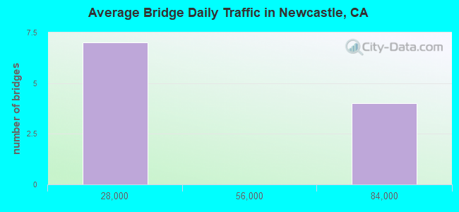
- 354,098Total average daily traffic
- 2,215Total average daily truck traffic
- National Bridge Inventory (NBI) Registered Bridges for Newcastle
- No street view available for this location
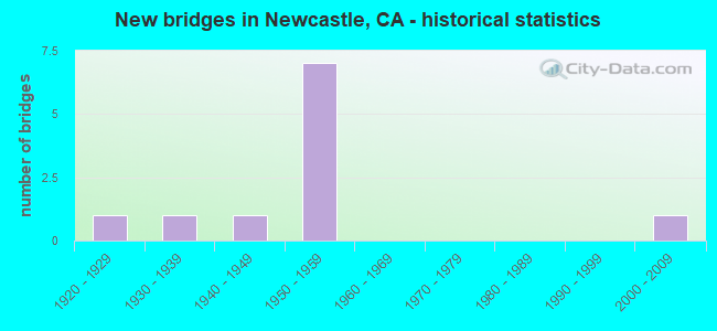
- New bridges - historical statistics
- 11920-1929
- 11930-1939
- 11940-1949
- 71950-1959
- 12000-2009
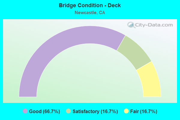
- Bridge Condition - Deck
- 66.7%Good
- 16.7%Satisfactory
- 16.7%Fair
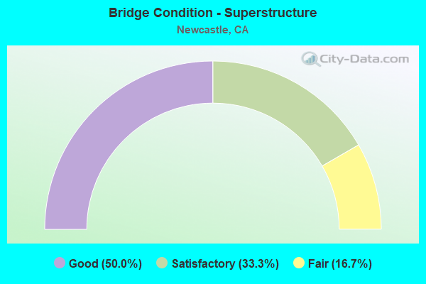
- Bridge Condition - Superstructure
- 50.0%Good
- 33.3%Satisfactory
- 16.7%Fair
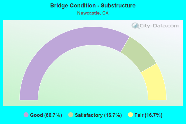
- Bridge Condition - Substructure
- 66.7%Good
- 16.7%Satisfactory
- 16.7%Fair
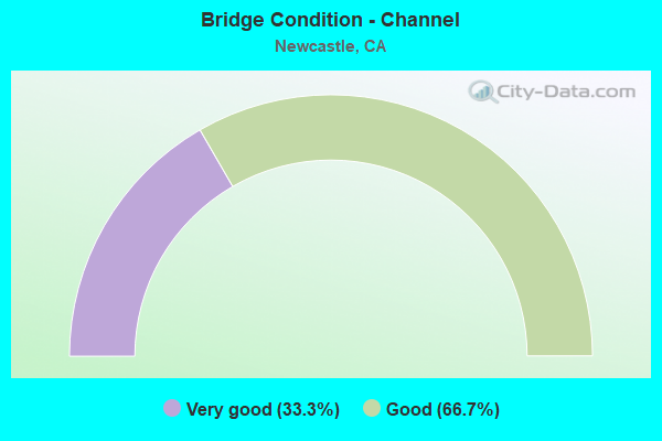
- Bridge Condition - Channel
- 33.3%Very good
- 66.7%Good
Find on map >> Show street view
Structure Number: 19 0101, Location: 03-PLA-080-12.30 (Lat: 38.854458, Lng: -121.144286), Route carried "on" structure: County highway , Year Built: 1959, Status: Open, Structure Length: 8.56m (28.08ft), Average Daily Traffic: 459 (year 1998), Truck Traffic: 1%, Average Future Daily Traffic: 1,152 (year 2039), Design Load: HS 20, Features Intersected: INTERSTATE ROUTE 80, Facility Carried by Structure: GILARDI ROAD
Minimum Vertical Clearance: 30+ m (98+ ft), Kilometerpoint: 0.000, Lanes on structure: 2, Lanes under structure: 6, Owner: State Highway Agency, Approaching Roadway Width: 9.0m (29.5ft), Skew: 4 degrees, Material/Design: Concrete continuous, Design/Construction: Box Beam or Girders - Multiple, Number Of Spans In Main Unit: 4, Length of Maximum Span: 25.0m (82.0ft), Curb or Sidewalk Widths: Left: 0.0m, Right: 1.5m (4.9ft), Curb-To-Curb Width: 9.0m (29.5ft), Out-to-Out Width: 11.3m (37.1ft)
Condition: Deck: Good, Superstructure: Good, Substructure: Good, Operating Rating: 55.4 metric tons, Method Used To Determine Operating Rating: Load and Resistance Factor Rating (LRFR) rating reported by rating factor(RF) method using HL-93 loadings, Inventory Rating: 42.8 metric tons, Method Used To Determine Inventory Rating: Load and Resistance Factor Rating (LRFR) rating reported by rating factor(RF) method using HL-93 loadings, Structural Evaluation: Better than present minimum criteria, Deck Geometry: Somewhat better than minimum adequacy, Underclear: Meets minimum limits, Approach Roadway Alignment: Equal to present desirable criteria, Designated Inspection Frequency: Every 24 months, Inspection Date: October 2021, Deck Structure Type: Concrete Cast-file-Place, Wearing Surface/Protective System: Wearing Surface: Integral Concrete
Find on map >> Show street view
Structure Number: 19 0102, Location: 03-PLA-080-13.81 (Lat: 38.873256, Lng: -121.131864), Route carried "on" structure: County highway , Year Built: 1959, Status: Open, Structure Length: 6.80m (22.31ft), Average Daily Traffic: 8,493 (year 2001), Truck Traffic: 1%, Average Future Daily Traffic: 21,806 (year 2043), Design Load: HS 20, Features Intersected: INTERSTATE ROUTE 80, Facility Carried by Structure: NEWCASTLE ROAD
Minimum Vertical Clearance: 30+ m (98+ ft), Kilometerpoint: 0.000, Lanes on structure: 2, Lanes under structure: 6, Owner: State Highway Agency, Approaching Roadway Width: 9.0m (29.5ft), Skew: 2 degrees, Material/Design: Concrete continuous, Design/Construction: Box Beam or Girders - Multiple, Number Of Spans In Main Unit: 4, Length of Maximum Span: 25.3m (83.0ft), Curb-To-Curb Width: 9.0m (29.5ft), Out-to-Out Width: 11.3m (37.1ft)
Condition: Deck: Good, Superstructure: Good, Substructure: Good, Operating Rating: 48.3 metric tons, Method Used To Determine Operating Rating: Load and Resistance Factor Rating (LRFR) rating reported by rating factor(RF) method using HL-93 loadings, Inventory Rating: 37.3 metric tons, Method Used To Determine Inventory Rating: Load and Resistance Factor Rating (LRFR) rating reported by rating factor(RF) method using HL-93 loadings, Structural Evaluation: Better than present minimum criteria, Deck Geometry: Meets minimum limits, Underclear: High priority of corrective action, Approach Roadway Alignment: Equal to present minimum criteria, Designated Inspection Frequency: Every 24 months, Inspection Date: October 2021, Deck Structure Type: Concrete Cast-file-Place, Wearing Surface/Protective System: Wearing Surface: Integral Concrete
Find on map >> Show street view
Structure Number: 19 0104, Location: 03-PLA-080-14.30 (Lat: 38.878036, Lng: -121.126050), Route carried "on" structure: Interstate 80, Year Built: 1959, Year Reconstructed: 1975, Status: Open, Structure Length: 3.44m (11.29ft), Average Daily Traffic: 77,000 (year 2009), Average Future Daily Traffic: 135,682 (year 2039), Design Load: HS 20, Features Intersected: STATE ROUTE 193
Minimum Vertical Clearance: 30+ m (98+ ft), Kilometerpoint: 14.300, Lanes on structure: 6, Lanes under structure: 2, Base Highway Network: Yes (, Subroute: 2), Owner: State Highway Agency, Approaching Roadway Width: 36.8m (120.7ft), Skew: 30 degrees, Material/Design: Concrete continuous, Design/Construction: Slab, Number Of Spans In Main Unit: 3, Length of Maximum Span: 13.1m (43.0ft), Curb-To-Curb Width: 36.8m (120.7ft), Out-to-Out Width: 38.0m (124.7ft)
Condition: Deck: Satisfactory, Superstructure: Satisfactory, Substructure: Good, Operating Rating: 76.8 metric tons, Method Used To Determine Operating Rating: Load Factor (LF), Inventory Rating: 46.0 metric tons, Method Used To Determine Inventory Rating: Load Factor (LF), Structural Evaluation: Equal to present minimum criteria, Deck Geometry: Superior to present desirable criteria, Underclear: Meets minimum limits, Approach Roadway Alignment: Equal to present desirable criteria, Designated Inspection Frequency: Every 24 months, Inspection Date: October 2021, Deck Structure Type: Concrete Cast-file-Place, Wearing Surface/Protective System: Wearing Surface: Integral Concrete
Find on map >> Show street view
Structure Number: 19C0134, Location: 0.45 MI W AUBURN-FOLSOM R (Lat: 38.854669, Lng: -121.115928), Route carried "on" structure: County highway , Year Built: 1940, Status: Open, Structure Length: 0.76m (2.49ft), Average Daily Traffic: 262 (year 2010), Truck Traffic: 1%, Average Future Daily Traffic: 373 (year 2042), Features Intersected: SOUTH CANAL, Facility Carried by Structure: POWERHOUSE RD
Minimum Vertical Clearance: 30+ m (98+ ft), Kilometerpoint: 0.000, Lanes on structure: 2, Owner: County Highway Agency, Approaching Roadway Width: 5.2m (17.1ft), Skew: 1 degrees, Material/Design: Concrete, Design/Construction: Tee Beam, Number Of Spans In Main Unit: 1, Length of Maximum Span: 7.0m (23.0ft), Curb-To-Curb Width: 6.2m (20.3ft), Out-to-Out Width: 7.0m (23.0ft)
Condition: Deck: Good, Superstructure: Fair, Substructure: Fair, Channel: Very good, Operating Rating: 28.8 metric tons, Method Used To Determine Operating Rating: Field evaluation and documented engineering judgment, Inventory Rating: 17.2 metric tons, Method Used To Determine Inventory Rating: Field evaluation and documented engineering judgment, Structural Evaluation: Somewhat better than minimum adequacy, Deck Geometry: Meets minimum limits, Waterway Adequacy: Better than present minimum criteria, Approach Roadway Alignment: Equal to present minimum criteria, Designated Inspection Frequency: Every 24 months, Inspection Date: November 2020, Deck Structure Type: Concrete Cast-file-Place
Find on map >> Show street view
Structure Number: 19C0235, Location: NEAR CHILI HILL RD (Lat: 38.890789, Lng: -121.124508), Route carried "on" structure: County highway , Year Built: 2007, Status: Open, Structure Length: 2.80m (9.19ft), Average Daily Traffic: 1,561 (year 2006), Truck Traffic: 4%, Average Future Daily Traffic: 1,918 (year 2037), Features Intersected: AUBURN RAVINE, Facility Carried by Structure: LOZANOS RD
Minimum Vertical Clearance: 30+ m (98+ ft), Kilometerpoint: 0.000, Lanes on structure: 2, Owner: County Highway Agency, Approaching Roadway Width: 10.0m (32.8ft), Skew: 4 degrees, Material/Design: Prestressed concrete, Design/Construction: Box Beam or Girders - Multiple, Number Of Spans In Main Unit: 1, Length of Maximum Span: 28.0m (91.9ft), Curb or Sidewalk Widths: Left: 0.2m (0.7ft), Right: 1.5m (4.9ft), Curb-To-Curb Width: 10.0m (32.8ft), Out-to-Out Width: 11.6m (38.1ft)
Condition: Deck: Good, Superstructure: Good, Substructure: Good, Channel: Good, Operating Rating: 54.1 metric tons, Method Used To Determine Operating Rating: Field evaluation and documented engineering judgment, Inventory Rating: 32.4 metric tons, Method Used To Determine Inventory Rating: Field evaluation and documented engineering judgment, Structural Evaluation: Better than present minimum criteria, Deck Geometry: Somewhat better than minimum adequacy, Waterway Adequacy: Somewhat better than minimum adequacy, Approach Roadway Alignment: Equal to present desirable criteria, Designated Inspection Frequency: Every 48 months, Inspection Date: April 2019, Deck Structure Type: Concrete Cast-file-Place
Find on map >> Show street view
Structure Number: 50753000003009, Location: NO DATA ENTERED (Lat: 35.028994, Lng: -120.195319), Route carried "on" structure: Federal lands road 11N05, Year Built: 1923, Status: Open, Structure Length: 3.72m (12.20ft), Average Daily Traffic: 50 (year 0000), Average Future Daily Traffic: 75 (year 2042), Features Intersected: MIRANDA PINE CREEK
Minimum Vertical Clearance: 30+ m (98+ ft), Kilometerpoint: 0.001, Lanes on structure: 2, Owner: U.S. Forest Service, Approaching Roadway Width: 7.9m (25.9ft), Material/Design: Concrete, Design/Construction: Stringer/Multi-beam, Number Of Spans In Main Unit: 3, Length of Maximum Span: 36.6m (120.1ft), Curb or Sidewalk Widths: Left: 0.5m (1.6ft), Right: 0.5m (1.6ft), Curb-To-Curb Width: 6.4m (21.0ft), Out-to-Out Width: 7.3m (24.0ft)
Condition: Deck: Fair, Superstructure: Satisfactory, Substructure: Satisfactory, Channel: Good, Deck Geometry: Somewhat better than minimum adequacy, Waterway Adequacy: Equal to present desirable criteria, Approach Roadway Alignment: Equal to present desirable criteria, Designated Inspection Frequency: Every 24 months, Inspection Date: September 2021, Deck Structure Type: Concrete Cast-file-Place, Wearing Surface/Protective System: Wearing Surface: Monolithic Concrete
Find on map >> Show street view
Structure Number: 19 0101, Location: 03-PLA-080-12.30 (Lat: 38.854458, Lng: -121.144286), Route carried "under" structure: Interstate 80, Year Built: 1959, Structure Length: 0. m, Average Daily Traffic: 77,000 (year 2009), Features Intersected: INTERSTATE ROUTE 80, Facility Carried by Structure: GILARDI ROAD
Minimum Vertical Clearance: 5.05m (16.57ft), Kilometerpoint: 12.300, Lanes on structure: 2, Lanes under structure: 6, Material/Design: Concrete continuous, Design/Construction: Box Beam or Girders - Multiple, Length of Maximum Span: 25.0m (82.0ft)
Find on map >> Show street view
Structure Number: 19 0102, Location: 03-PLA-080-13.81 (Lat: 38.873256, Lng: -121.131864), Route carried "under" structure: Interstate 80, Year Built: 1959, Structure Length: 0. m, Average Daily Traffic: 77,000 (year 2009), Features Intersected: INTERSTATE ROUTE 80, Facility Carried by Structure: NEWCASTLE ROAD
Minimum Vertical Clearance: 5.05m (16.57ft), Kilometerpoint: 13.810, Lanes on structure: 2, Lanes under structure: 6, Material/Design: Concrete continuous, Design/Construction: Box Beam or Girders - Multiple, Length of Maximum Span: 25.3m (83.0ft)
Find on map >> Show street view
Structure Number: 19 0103, Location: 03-PLA-080-13.99 (Lat: 38.875639, Lng: -121.131244), Route carried "under" structure: Interstate 80, Year Built: 1959, Structure Length: 0. m, Average Daily Traffic: 77,000 (year 2009), Features Intersected: INTERSTATE 80, Facility Carried by Structure: UP RR,BNSF,AMTRAK
Minimum Vertical Clearance: 4.80m (15.75ft), Kilometerpoint: 13.990, Lanes under structure: 6, Material/Design: Steel, Design/Construction: Stringer/Multi-beam, Length of Maximum Span: 21.9m (71.9ft)
Find on map >> Show street view
Structure Number: 19 0104, Location: 03-PLA-080-14.30 (Lat: 38.878036, Lng: -121.126050), Route carried "under" structure: State highway 193, Year Built: 1959, Structure Length: 0. m, Average Daily Traffic: 10,000 (year 2009), Truck Traffic: 8%, Features Intersected: STATE ROUTE 193, Facility Carried by Structure: INTERSTATE 80
Minimum Vertical Clearance: 4.59m (15.06ft), Kilometerpoint: 10.180, Lanes on structure: 6, Lanes under structure: 2, Material/Design: Concrete continuous, Design/Construction: Slab, Length of Maximum Span: 13.1m (43.0ft)
Find on map >> Show street view
Structure Number: 19C0053, Location: 10.6 MI SACTO CO LINE (Lat: 38.847153, Lng: -121.110839), Route carried "under" structure: County highway , Year Built: 1931, Structure Length: 0. m, Average Daily Traffic: 25,273 (year 2009), Truck Traffic: 5%, Features Intersected: PG&E OH FLUME, Facility Carried by Structure: AUBURN FOLSOM RD
Minimum Vertical Clearance: 4.67m (15.32ft), Kilometerpoint: 0.000, Lanes under structure: 2, Material/Design: Concrete, Design/Construction: Stringer/Multi-beam, Length of Maximum Span: 11.6m (38.1ft)