Bridge Statistics for Newbury, Massachusetts (MA)
Condition, Traffic, Stress, Structural Evaluation, Project Costs
- National Bridge Inventory (NBI) Statistics
- 18Number of bridges
- 226ft / 68.5mTotal length
- $47,408,000Total costs
- 369,308Total average daily traffic
- 28,390Total average daily truck traffic
- National Bridge Inventory (NBI) Registered Bridges for Newbury
- No street view available for this location
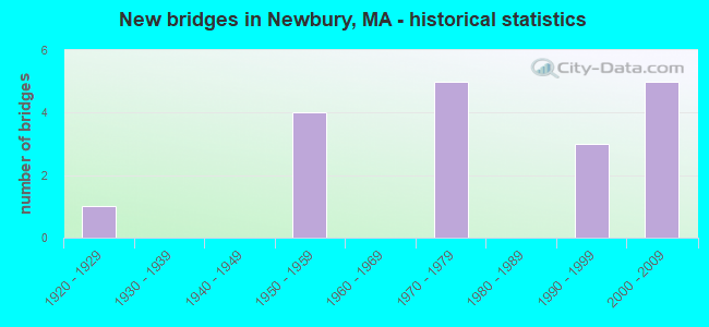
- New bridges - historical statistics
- 11920-1929
- 41950-1959
- 51970-1979
- 31990-1999
- 52000-2009
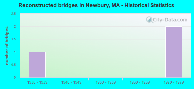
- Reconstructed bridges - Historical Statistics
- 11930-1939
- 01940-1949
- 01950-1959
- 01960-1969
- 21970-1979
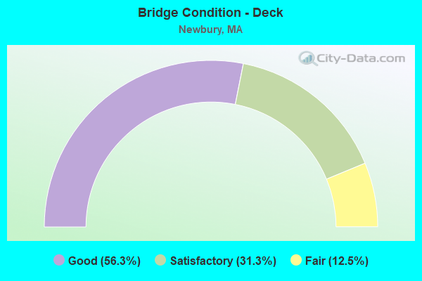
- Bridge Condition - Deck
- 56.3%Good
- 31.3%Satisfactory
- 12.5%Fair
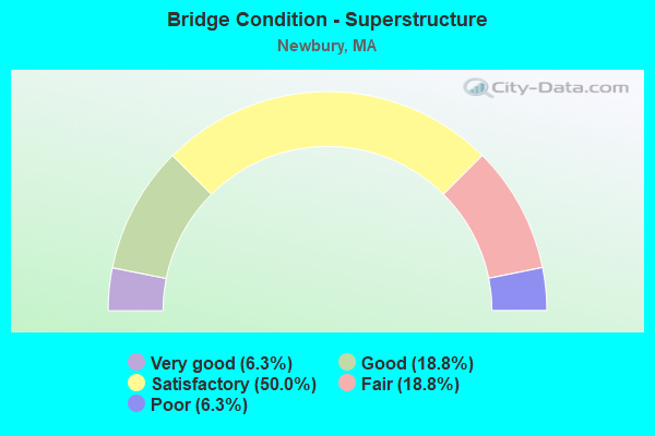
- Bridge Condition - Superstructure
- 6.3%Very good
- 18.8%Good
- 50.0%Satisfactory
- 18.8%Fair
- 6.3%Poor
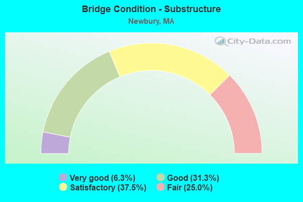
- Bridge Condition - Substructure
- 6.3%Very good
- 31.3%Good
- 37.5%Satisfactory
- 25.0%Fair
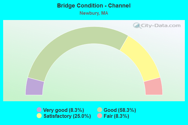
- Bridge Condition - Channel
- 8.3%Very good
- 58.3%Good
- 25.0%Satisfactory
- 8.3%Fair
Find on map >> Show street view
Structure Number: N100012RGMUNNBI, Location: 0.5 MI W OF US-1 (Lat: 42.758911, Lng: -70.901000), Route carried "on" structure: City street , Year Built: 1995, Status: Open, Structure Length: 3.47m (11.38ft), Average Daily Traffic: 1,550 (year 2017), Truck Traffic: 8%, Average Future Daily Traffic: 2,211 (year 2032), Design Load: HS 20, Features Intersected: WATER PARKER RIVER, Facility Carried by Structure: HWY MIDDLE RD
Minimum Vertical Clearance: 30+ m (98+ ft), Kilometerpoint: 1.062, Lanes on structure: 2, Owner: Town or Township Highway Agency, Approaching Roadway Width: 6.7m (22.0ft), Material/Design: Prestressed concrete continuous, Design/Construction: Box Beam or Girders - Multiple, Number Of Spans In Main Unit: 3, Length of Maximum Span: 17.4m (57.1ft), Curb-To-Curb Width: 6.7m (22.0ft), Out-to-Out Width: 7.6m (24.9ft)
Condition: Deck: Satisfactory, Superstructure: Satisfactory, Substructure: Satisfactory, Channel: Good, Operating Rating: 49.7 metric tons, Method Used To Determine Operating Rating: Allowable Stress (AS), Inventory Rating: 38.1 metric tons, Method Used To Determine Inventory Rating: Allowable Stress (AS), Structural Evaluation: Equal to present minimum criteria, Deck Geometry: High priority of corrective action, Waterway Adequacy: Equal to present desirable criteria, Approach Roadway Alignment: Equal to present minimum criteria, Length Of Structure Improvement: 3.50m (11.48ft), Designated Inspection Frequency: Every 24 months, Inspection Date: November 2021, Bridge Improvement Cost: $2,211,000, Roadway Improvement Cost: $222,000, Total Project Cost: $3,317,000 ( Estimate for 2022), Deck Structure Type: Concrete Precast Panels, Wearing Surface/Protective System: Wearing Surface: Bituminous, Membrane: Built-up, Deck Protection: Epoxy Coated Reinforcing
Find on map >> Show street view
Structure Number: N10003AF8MUNNBI, Location: .62 K SOUTH OF NEWBURYPO (Lat: 42.790292, Lng: -70.876578), Route carried "on" structure: City street , Year Built: 1997, Status: Open, Structure Length: 1.78m (5.84ft), Average Daily Traffic: 2,974 (year 2019), Truck Traffic: 13%, Average Future Daily Traffic: 10,423 (year 2032), Design Load: HS 20, Features Intersected: WATER LITTLE RIVER, Facility Carried by Structure: HWY HANOVER ST
Minimum Vertical Clearance: 0.00m, Kilometerpoint: 0.177, Lanes on structure: 2, Owner: Town or Township Highway Agency, Approaching Roadway Width: 6.7m (22.0ft), Material/Design: Prestressed concrete, Design/Construction: Box Beam or Girders - Single/Spread, Number Of Spans In Main Unit: 1, Length of Maximum Span: 16.7m (54.8ft), Curb or Sidewalk Widths: Left: 1.5m (4.9ft), Right: 0.0m, Curb-To-Curb Width: 8.5m (27.9ft), Out-to-Out Width: 10.9m (35.8ft)
Condition: Deck: Good, Superstructure: Satisfactory, Substructure: Good, Channel: Good, Operating Rating: 63.6 metric tons, Method Used To Determine Operating Rating: Allowable Stress (AS), Inventory Rating: 41.6 metric tons, Method Used To Determine Inventory Rating: Allowable Stress (AS), Structural Evaluation: Equal to present minimum criteria, Deck Geometry: Meets minimum limits, Waterway Adequacy: Equal to present desirable criteria, Approach Roadway Alignment: Equal to present desirable criteria, Length Of Structure Improvement: 1.80m (5.91ft), Designated Inspection Frequency: Every 24 months, Inspection Date: November 2021, Bridge Improvement Cost: $827,000, Roadway Improvement Cost: $83,000, Total Project Cost: $1,241,000 ( Estimate for 2022), Deck Structure Type: Concrete Cast-file-Place, Wearing Surface/Protective System: Wearing Surface: Bituminous, Membrane: Built-up, Deck Protection: Epoxy Coated Reinforcing
Find on map >> Show street view
Structure Number: N100042TBDOTNBI, Location: .2 MI S OF MBTA (Lat: 42.792028, Lng: -70.877728), Route carried "on" structure: State highway 1, Year Built: 1922, Year Reconstructed: 1935, Status: Open, Structure Length: 0.76m (2.49ft), Average Daily Traffic: 44,612 (year 2019), Truck Traffic: 7%, Average Future Daily Traffic: 16,267 (year 2032), Design Load: H 20, Features Intersected: WATER LITTLE RIVER
Minimum Vertical Clearance: 30+ m (98+ ft), Kilometerpoint: 117.238, Lanes on structure: 4, Base Highway Network: Yes, Owner: State Highway Agency, Approaching Roadway Width: 19.8m (65.0ft), Skew: 20 degrees, Material/Design: Concrete, Design/Construction: Tee Beam, Number Of Spans In Main Unit: 1, Length of Maximum Span: 6.4m (21.0ft), Curb or Sidewalk Widths: Left: 0.2m (0.7ft), Right: 0.2m (0.7ft), Curb-To-Curb Width: 19.8m (65.0ft), Out-to-Out Width: 22.9m (75.1ft)
Condition: Deck: Satisfactory, Superstructure: Poor, Substructure: Satisfactory, Channel: Satisfactory, Operating Rating: 47.7 metric tons, Method Used To Determine Operating Rating: Load Factor (LF), Inventory Rating: 28.6 metric tons, Method Used To Determine Inventory Rating: Load Factor (LF), Structural Evaluation: Meets minimum limits, Deck Geometry: Better than present minimum criteria, Waterway Adequacy: Equal to present desirable criteria, Approach Roadway Alignment: Equal to present desirable criteria, Length Of Structure Improvement: 1.50m (4.92ft), Designated Inspection Frequency: Every 12 months, Other Special Inspection Frequency: Every 12 months, Inspection Date: July 2021, Other Special Inspection Date: July 2021, Bridge Improvement Cost: $1,980,000, Roadway Improvement Cost: $199,000, Total Project Cost: $2,971,000 ( Estimate for 2022), Deck Structure Type: Concrete Cast-file-Place, Wearing Surface/Protective System: Wearing Surface: Bituminous
Find on map >> Show street view
Structure Number: N100059GQMUNNBI, Location: 1 MI. SW OF RT. 1A (Lat: 42.774483, Lng: -70.865181), Route carried "on" structure: City street , Year Built: 2007, Status: Open, Structure Length: 2.89m (9.48ft), Average Daily Traffic: 400 (year 2021), Truck Traffic: 5%, Average Future Daily Traffic: 948 (year 2032), Design Load: HS 25 or greater, Features Intersected: WATER LITTLE RIVER, Facility Carried by Structure: HWY HAY ST
Minimum Vertical Clearance: 30+ m (98+ ft), Kilometerpoint: 1.609, Lanes on structure: 2, Owner: Town or Township Highway Agency, Approaching Roadway Width: 7.9m (25.9ft), Material/Design: Concrete continuous, Design/Construction: Slab, Number Of Spans In Main Unit: 4, Length of Maximum Span: 6.8m (22.3ft), Curb-To-Curb Width: 7.9m (25.9ft), Out-to-Out Width: 8.8m (28.9ft)
Condition: Deck: Good, Superstructure: Good, Substructure: Good, Channel: Good, Operating Rating: 75.5 metric tons, Method Used To Determine Operating Rating: Load Factor (LF), Inventory Rating: 45.2 metric tons, Method Used To Determine Inventory Rating: Load Factor (LF), Structural Evaluation: Better than present minimum criteria, Deck Geometry: Somewhat better than minimum adequacy, Waterway Adequacy: Better than present minimum criteria, Approach Roadway Alignment: Equal to present desirable criteria, Length Of Structure Improvement: 2.90m (9.51ft), Designated Inspection Frequency: Every 24 months, Underwater Inspection Frequency: Every 36 months, Inspection Date: January 2021, Underwater Inspection Date: July 2021, Bridge Improvement Cost: $848,000, Roadway Improvement Cost: $85,000, Total Project Cost: $1,273,000 ( Estimate for 2022), Deck Structure Type: Concrete Cast-file-Place, Wearing Surface/Protective System: Wearing Surface: Bituminous, Membrane: Other, Deck Protection: Epoxy Coated Reinforcing
Find on map >> Show street view
Structure Number: N10006AU8MUNNBI, Location: 1.2MI E OF RT.1 (Lat: 42.771975, Lng: -70.862083), Route carried "on" structure: City street , Year Built: 2000, Status: Open, Structure Length: 2.72m (8.92ft), Average Daily Traffic: 400 (year 2018), Truck Traffic: 10%, Average Future Daily Traffic: 1,421 (year 2032), Design Load: HS 20, Features Intersected: WATER LITTLE RIVER, Facility Carried by Structure: HWY NEWMAN RD
Minimum Vertical Clearance: 30+ m (98+ ft), Kilometerpoint: 0.386, Lanes on structure: 2, Owner: Town or Township Highway Agency, Approaching Roadway Width: 9.4m (30.8ft), Material/Design: Prestressed concrete continuous, Design/Construction: Slab, Number Of Spans In Main Unit: 2, Length of Maximum Span: 13.6m (44.6ft), Curb-To-Curb Width: 6.8m (22.3ft), Out-to-Out Width: 7.7m (25.3ft)
Condition: Deck: Good, Superstructure: Good, Substructure: Good, Channel: Good, Operating Rating: 57.9 metric tons, Method Used To Determine Operating Rating: Load Factor (LF), Inventory Rating: 34.7 metric tons, Method Used To Determine Inventory Rating: Load Factor (LF), Structural Evaluation: Better than present minimum criteria, Deck Geometry: Meets minimum limits, Waterway Adequacy: Better than present minimum criteria, Approach Roadway Alignment: Equal to present minimum criteria, Length Of Structure Improvement: 2.80m (9.19ft), Designated Inspection Frequency: Every 24 months, Underwater Inspection Frequency: Every 36 months, Inspection Date: May 2021, Underwater Inspection Date: April 2020, Bridge Improvement Cost: $1,109,000, Roadway Improvement Cost: $111,000, Total Project Cost: $1,664,000 ( Estimate for 2022), Deck Structure Type: Concrete Precast Panels, Wearing Surface/Protective System: Wearing Surface: Bituminous, Membrane: Other, Deck Protection: Other
Find on map >> Show street view
Structure Number: N10008AGTMUNNBI, Location: 0.48 KM E OF I 95 (Lat: 42.749036, Lng: -70.939900), Route carried "on" structure: City street , Year Built: 2000, Status: Open, Structure Length: 1.71m (5.61ft), Average Daily Traffic: 300 (year 2016), Average Future Daily Traffic: 790 (year 2031), Design Load: HS 20, Features Intersected: WATER PARKER RIVER, Facility Carried by Structure: HWY LARKIN RD
Minimum Vertical Clearance: 30+ m (98+ ft), Kilometerpoint: 0.644, Lanes on structure: 2, Owner: Town or Township Highway Agency, Approaching Roadway Width: 8.2m (26.9ft), Material/Design: Prestressed concrete, Design/Construction: Slab, Number Of Spans In Main Unit: 1, Length of Maximum Span: 15.7m (51.5ft), Curb or Sidewalk Widths: Left: 0.0m, Right: 1.5m (4.9ft), Curb-To-Curb Width: 6.8m (22.3ft), Out-to-Out Width: 9.2m (30.2ft)
Condition: Deck: Good, Superstructure: Good, Substructure: Good, Channel: Very good, Operating Rating: 39.6 metric tons, Method Used To Determine Operating Rating: Load Factor (LF), Inventory Rating: 34.4 metric tons, Method Used To Determine Inventory Rating: Load Factor (LF), Structural Evaluation: Better than present minimum criteria, Deck Geometry: Meets minimum limits, Waterway Adequacy: Superior to present desirable criteria, Approach Roadway Alignment: Equal to present minimum criteria, Length Of Structure Improvement: 1.80m (5.91ft), Designated Inspection Frequency: Every 24 months, Underwater Inspection Frequency: Every 24 months, Inspection Date: December 2020, Underwater Inspection Date: November 2021, Bridge Improvement Cost: $722,000, Roadway Improvement Cost: $73,000, Total Project Cost: $1,084,000 ( Estimate for 2022), Deck Structure Type: Concrete Precast Panels, Wearing Surface/Protective System: Wearing Surface: Bituminous, Membrane: Built-up, Deck Protection: Epoxy Coated Reinforcing
Find on map >> Show street view
Structure Number: N100092TADOTNBI, Location: 2.6 MI S MBTA (Lat: 42.759692, Lng: -70.891658), Route carried "on" structure: US 1, Year Built: 1972, Status: Open, Structure Length: 5.34m (17.52ft), Average Daily Traffic: 9,550 (year 2018), Truck Traffic: 4%, Average Future Daily Traffic: 13,740 (year 2031), Design Load: HS 20, Features Intersected: WATER PARKER RIVER
Minimum Vertical Clearance: 30+ m (98+ ft), Kilometerpoint: 113.287, Lanes on structure: 2, Base Highway Network: Yes, Owner: State Highway Agency, Approaching Roadway Width: 13.4m (44.0ft), Skew: 3 degrees, Material/Design: Steel continuous, Design/Construction: Stringer/Multi-beam, Number Of Spans In Main Unit: 2, Length of Maximum Span: 25.9m (85.0ft), Curb or Sidewalk Widths: Left: 0.5m (1.6ft), Right: 0.5m (1.6ft), Curb-To-Curb Width: 13.4m (44.0ft), Out-to-Out Width: 15.2m (49.9ft)
Condition: Deck: Satisfactory, Superstructure: Fair, Substructure: Fair, Channel: Satisfactory, Operating Rating: 61.9 metric tons, Method Used To Determine Operating Rating: Load Factor (LF), Inventory Rating: 37.1 metric tons, Method Used To Determine Inventory Rating: Load Factor (LF), Structural Evaluation: Somewhat better than minimum adequacy, Deck Geometry: Equal to present minimum criteria, Waterway Adequacy: Equal to present desirable criteria, Approach Roadway Alignment: Better than present minimum criteria, Length Of Structure Improvement: 5.40m (17.72ft), Designated Inspection Frequency: Every 24 months, Underwater Inspection Frequency: Every 36 months, Inspection Date: August 2020, Underwater Inspection Date: August 2019, Bridge Improvement Cost: $3,225,000, Roadway Improvement Cost: $323,000, Total Project Cost: $4,838,000 ( Estimate for 2022), Deck Structure Type: Concrete Cast-file-Place, Wearing Surface/Protective System: Wearing Surface: Bituminous, Membrane: Built-up
Find on map >> Show street view
Structure Number: N100108PDDOTNBI, Location: Plum Island (Lat: 42.798167, Lng: -70.848000), Route carried "on" structure: Federal lands road , Year Built: 2007, Status: Open, Structure Length: 2.71m (8.89ft), Average Daily Traffic: 120 (year 2021), Truck Traffic: 1%, Average Future Daily Traffic: 175 (year 2041), Design Load: HL 93, Features Intersected: Unnamed drainage, Facility Carried by Structure: Unnamed roadway
Minimum Vertical Clearance: 30.48m (100.00ft), Kilometerpoint: 0.016, Lanes on structure: 2, Owner: Bureau of Fish and Wildlife, Approaching Roadway Width: 6.7m (22.0ft), Material/Design: Prestressed concrete, Design/Construction: Stringer/Multi-beam, Number Of Spans In Main Unit: 3, Length of Maximum Span: 9.1m (29.9ft), Curb or Sidewalk Widths: Left: 6.0m (19.7ft), Right: 0.0m, Curb-To-Curb Width: 6.7m (22.0ft), Out-to-Out Width: 9.1m (29.9ft)
Condition: Deck: Good, Superstructure: Very good, Substructure: Very good, Channel: Good, Operating Rating: 37.2 metric tons, Method Used To Determine Operating Rating: Load and Resistance Factor (LRFR), Inventory Rating: 29.0 metric tons, Method Used To Determine Inventory Rating: Load and Resistance Factor (LRFR), Structural Evaluation: Better than present minimum criteria, Deck Geometry: Meets minimum limits, Waterway Adequacy: Equal to present desirable criteria, Approach Roadway Alignment: Equal to present desirable criteria, Designated Inspection Frequency: Every 24 months, Inspection Date: July 2021, Deck Structure Type: Concrete Cast-file-Place, Wearing Surface/Protective System: Wearing Surface: Monolithic Concrete, Deck Protection: Epoxy Coated Reinforcing
Find on map >> Show street view
Structure Number: N100108PDDOTNBI, Location: 2.8 MI S NEWBURY TOWN HAL (Lat: 42.762456, Lng: -70.847714), Route carried "on" structure: City street , Year Built: 2008, Status: Open, Structure Length: 11.14m (36.55ft), Average Daily Traffic: 5,172 (year 2019), Truck Traffic: 3%, Average Future Daily Traffic: 12,476 (year 2032), Design Load: HS 20, Features Intersected: WATER PARKER RIVER, Facility Carried by Structure: ST 1 A/HIGH RD
Minimum Vertical Clearance: 30+ m (98+ ft), Kilometerpoint: 113.185, Lanes on structure: 2, Owner: State Highway Agency, Approaching Roadway Width: 13.4m (44.0ft), Navigation Control: Yes ( Vertical Clearance: 3.9m (12.8ft), Horizontal Clearance: 35.0m (114.8ft)), Material/Design: Prestressed concrete continuous, Design/Construction: Stringer/Multi-beam, Number Of Spans In Main Unit: 3, Length of Maximum Span: 36.1m (118.4ft), Curb or Sidewalk Widths: Left: 0.0m, Right: 2.0m (6.6ft), Curb-To-Curb Width: 13.4m (44.0ft), Out-to-Out Width: 16.3m (53.5ft)
Condition: Deck: Good, Superstructure: Satisfactory, Substructure: Satisfactory, Channel: Good, Operating Rating: 89.5 metric tons, Method Used To Determine Operating Rating: Load Factor (LF), Inventory Rating: 53.6 metric tons, Method Used To Determine Inventory Rating: Load Factor (LF), Structural Evaluation: Equal to present minimum criteria, Deck Geometry: Equal to present minimum criteria, Waterway Adequacy: Equal to present desirable criteria, Approach Roadway Alignment: Equal to present desirable criteria, Length Of Structure Improvement: 11.20m (36.75ft), Designated Inspection Frequency: Every 24 months, Underwater Inspection Frequency: Every 36 months, Inspection Date: July 2021, Underwater Inspection Date: March 2019, Bridge Improvement Cost: $1,435,000, Roadway Improvement Cost: $144,000, Total Project Cost: $2,153,000 ( Estimate for 2022), Deck Structure Type: Concrete Cast-file-Place, Wearing Surface/Protective System: Wearing Surface: Bituminous, Membrane: Built-up, Deck Protection: Epoxy Coated Reinforcing
Find on map >> Show street view
Structure Number: N100112Y6DOTNBI, Location: .75 MI WEST ATLANTIC OCN (Lat: 42.797775, Lng: -70.821439), Route carried "on" structure: State highway , Year Built: 1973, Status: Open, Structure Length: 4.11m (13.48ft), Average Daily Traffic: 12,500 (year 2018), Truck Traffic: 3%, Average Future Daily Traffic: 14,687 (year 2031), Design Load: H 20, Features Intersected: WATER PLUM ISLAND RIVER, Facility Carried by Structure: HWY PLM ISLN TPK
Minimum Vertical Clearance: 30+ m (98+ ft), Kilometerpoint: 2.736, Lanes on structure: 2, Owner: State Highway Agency, Approaching Roadway Width: 9.8m (32.2ft), Navigation Control: Yes ( Vertical Clearance: 4.0m (13.1ft), Horizontal Clearance: 12.2m (40.0ft)), Material/Design: Steel, Design/Construction: Movable - Bascule, Number Of Spans In Main Unit: 1, Number Of Approach Spans: 2, Length of Maximum Span: 29.0m (95.1ft), Curb or Sidewalk Widths: Left: 1.5m (4.9ft), Right: 0.5m (1.6ft), Curb-To-Curb Width: 9.8m (32.2ft), Out-to-Out Width: 11.7m (38.4ft)
Condition: Deck: Satisfactory, Superstructure: Satisfactory, Substructure: Satisfactory, Channel: Fair, Operating Rating: 43.0 metric tons, Method Used To Determine Operating Rating: Allowable Stress (AS), Inventory Rating: 31.2 metric tons, Method Used To Determine Inventory Rating: Allowable Stress (AS), Structural Evaluation: Equal to present minimum criteria, Deck Geometry: Meets minimum limits, Waterway Adequacy: Equal to present desirable criteria, Approach Roadway Alignment: Equal to present desirable criteria, Length Of Structure Improvement: 4.20m (13.78ft), Designated Inspection Frequency: Every 12 months, Critical Feature Inspection Frequency: Every 24 months, Underwater Inspection Frequency: Every 12 months, Inspection Date: September 2020, Critical Feature Inspection Date: September 2020, Underwater Inspection Date: December 2021, Bridge Improvement Cost: $1,931,000, Roadway Improvement Cost: $194,000, Total Project Cost: $2,897,000 ( Estimate for 2022), Deck Structure Type: Open Grating
Find on map >> Show street view
Structure Number: N10015AVUDOT634, Location: 0.2 MI N OF LITTLE RIVER (Lat: 42.794506, Lng: -70.876822), Route carried "on" structure: State highway 1, Year Built: 1998, Status: Open, Structure Length: 17.40m (57.09ft), Average Daily Traffic: 11,600 (year 2019), Truck Traffic: 10%, Average Future Daily Traffic: 16,425 (year 2032), Design Load: HS 20, Features Intersected: RR MBTA
Minimum Vertical Clearance: 30+ m (98+ ft), Kilometerpoint: 117.331, Lanes on structure: 4, Base Highway Network: Yes, Owner: State Highway Agency, Approaching Roadway Width: 24.0m (78.7ft), Skew: 36 degrees, Material/Design: Steel continuous, Design/Construction: Stringer/Multi-beam, Number Of Spans In Main Unit: 6, Length of Maximum Span: 38.5m (126.3ft), Curb or Sidewalk Widths: Left: 1.5m (4.9ft), Right: 0.0m, Curb-To-Curb Width: 22.4m (73.5ft), Out-to-Out Width: 23.2m (76.1ft)
Condition: Deck: Fair, Superstructure: Satisfactory, Substructure: Good, Operating Rating: 66.8 metric tons, Method Used To Determine Operating Rating: Load Factor (LF), Inventory Rating: 40.0 metric tons, Method Used To Determine Inventory Rating: Load Factor (LF), Structural Evaluation: Equal to present minimum criteria, Deck Geometry: Superior to present desirable criteria, Underclear: Somewhat better than minimum adequacy, Approach Roadway Alignment: Equal to present minimum criteria, Length Of Structure Improvement: 17.50m (57.41ft), Designated Inspection Frequency: Every 24 months, Inspection Date: October 2021, Bridge Improvement Cost: $7,654,000, Roadway Improvement Cost: $766,000, Total Project Cost: $11,482,000 ( Estimate for 2022), Deck Structure Type: Concrete Cast-file-Place, Wearing Surface/Protective System: Wearing Surface: Bituminous, Membrane: Built-up, Deck Protection: Epoxy Coated Reinforcing
Find on map >> Show street view
Structure Number: N100202VJDOTNBI, Location: .3 MI S CENTRAL STREET (Lat: 42.752031, Lng: -70.944511), Route carried "on" structure: Interstate 95, Year Built: 1976, Status: Open, Structure Length: 1.34m (4.40ft), Average Daily Traffic: 48,230 (year 2021), Truck Traffic: 10%, Average Future Daily Traffic: 107,550 (year 2032), Design Load: HS 20+Mod, Features Intersected: WATER PARKER RIVER
Minimum Vertical Clearance: 30+ m (98+ ft), Kilometerpoint: 130.679, Lanes on structure: 4, Base Highway Network: Yes, Owner: State Highway Agency, Approaching Roadway Width: 22.3m (73.2ft), Skew: 12 degrees, Material/Design: Steel, Design/Construction: Stringer/Multi-beam, Number Of Spans In Main Unit: 1, Length of Maximum Span: 12.2m (40.0ft), Curb or Sidewalk Widths: Left: 0.2m (0.7ft), Right: 0.2m (0.7ft), Curb-To-Curb Width: 19.7m (64.6ft), Out-to-Out Width: 21.1m (69.2ft)
Condition: Deck: Satisfactory, Superstructure: Fair, Substructure: Satisfactory, Channel: Good, Operating Rating: 63.4 metric tons, Method Used To Determine Operating Rating: Load Factor (LF), Inventory Rating: 38.0 metric tons, Method Used To Determine Inventory Rating: Load Factor (LF), Structural Evaluation: Somewhat better than minimum adequacy, Deck Geometry: Equal to present minimum criteria, Waterway Adequacy: Equal to present desirable criteria, Approach Roadway Alignment: Equal to present desirable criteria, Length Of Structure Improvement: 1.40m (4.59ft), Designated Inspection Frequency: Every 24 months, Underwater Inspection Frequency: Every 36 months, Inspection Date: November 2021, Underwater Inspection Date: April 2019, Bridge Improvement Cost: $1,161,000, Roadway Improvement Cost: $117,000, Total Project Cost: $1,742,000 ( Estimate for 2022), Deck Structure Type: Concrete Cast-file-Place, Wearing Surface/Protective System: Wearing Surface: Bituminous, Membrane: Built-up
Find on map >> Show street view
Structure Number: N100202VKDOTNBI, Location: .3 MI S CENTRAL STREET (Lat: 42.752314, Lng: -70.944894), Route carried "on" structure: Interstate 95, Year Built: 1951, Year Reconstructed: 1976, Status: Open, Structure Length: 1.34m (4.40ft), Average Daily Traffic: 52,000 (year 2021), Truck Traffic: 9%, Average Future Daily Traffic: 107,550 (year 2032), Design Load: HS 20+Mod, Features Intersected: WATER PARKER RIVER
Minimum Vertical Clearance: 30+ m (98+ ft), Kilometerpoint: 129.066, Lanes on structure: 4, Base Highway Network: Yes, Owner: State Highway Agency, Approaching Roadway Width: 20.1m (65.9ft), Skew: 12 degrees, Material/Design: Steel, Design/Construction: Stringer/Multi-beam, Number Of Spans In Main Unit: 1, Length of Maximum Span: 12.2m (40.0ft), Curb or Sidewalk Widths: Left: 0.2m (0.7ft), Right: 0.2m (0.7ft), Curb-To-Curb Width: 20.5m (67.3ft), Out-to-Out Width: 21.9m (71.9ft)
Condition: Deck: Good, Superstructure: Satisfactory, Substructure: Fair, Channel: Satisfactory, Operating Rating: 63.4 metric tons, Method Used To Determine Operating Rating: Load Factor (LF), Inventory Rating: 38.0 metric tons, Method Used To Determine Inventory Rating: Load Factor (LF), Structural Evaluation: Somewhat better than minimum adequacy, Deck Geometry: Equal to present minimum criteria, Waterway Adequacy: Equal to present desirable criteria, Approach Roadway Alignment: Equal to present desirable criteria, Length Of Structure Improvement: 1.40m (4.59ft), Designated Inspection Frequency: Every 24 months, Underwater Inspection Frequency: Every 36 months, Inspection Date: November 2021, Underwater Inspection Date: April 2019, Bridge Improvement Cost: $1,205,000, Roadway Improvement Cost: $121,000, Total Project Cost: $1,808,000 ( Estimate for 2022), Deck Structure Type: Concrete Cast-file-Place, Wearing Surface/Protective System: Wearing Surface: Bituminous, Membrane: Built-up
Find on map >> Show street view
Structure Number: N100212Y2DOTNBI, Location: QUARTER MILE N PARKER RIV (Lat: 42.756542, Lng: -70.941833), Route carried "on" structure: State highway , Year Built: 1976, Status: Open, Structure Length: 7.56m (24.80ft), Average Daily Traffic: 6,700 (year 2019), Truck Traffic: 6%, Average Future Daily Traffic: 5,685 (year 2032), Design Load: H 20, Features Intersected: I 95, Facility Carried by Structure: HWY CENTRAL ST
Minimum Vertical Clearance: 30+ m (98+ ft), Kilometerpoint: 0.571, Lanes on structure: 2, Lanes under structure: 8, Owner: State Highway Agency, Approaching Roadway Width: 12.2m (40.0ft), Material/Design: Steel continuous, Design/Construction: Stringer/Multi-beam, Number Of Spans In Main Unit: 2, Length of Maximum Span: 36.9m (121.1ft), Curb or Sidewalk Widths: Left: 0.0m, Right: 1.8m (5.9ft), Curb-To-Curb Width: 13.4m (44.0ft), Out-to-Out Width: 16.5m (54.1ft)
Condition: Deck: Fair, Superstructure: Fair, Substructure: Fair, Operating Rating: 58.7 metric tons, Method Used To Determine Operating Rating: Load Factor (LF), Inventory Rating: 35.2 metric tons, Method Used To Determine Inventory Rating: Load Factor (LF), Structural Evaluation: Somewhat better than minimum adequacy, Deck Geometry: Equal to present minimum criteria, Underclear: High priority of corrective action, Approach Roadway Alignment: Equal to present desirable criteria, Length Of Structure Improvement: 7.60m (24.93ft), Designated Inspection Frequency: Every 24 months, Inspection Date: Febuary 2021, Bridge Improvement Cost: $4,926,000, Roadway Improvement Cost: $493,000, Total Project Cost: $7,390,000 ( Estimate for 2022), Deck Structure Type: Concrete Cast-file-Place, Wearing Surface/Protective System: Wearing Surface: Bituminous, Membrane: Built-up
Find on map >> Show street view
Structure Number: N100222VLDOTNBI, Location: 2.1 MI N PARKER RIVER (Lat: 42.780208, Lng: -70.926061), Route carried "on" structure: Interstate 95, Year Built: 1976, Status: Open, Structure Length: 2.13m (6.99ft), Average Daily Traffic: 63,600 (year 2017), Truck Traffic: 10%, Average Future Daily Traffic: 79,597 (year 2032), Design Load: HS 20+Mod, Features Intersected: HWY SCOTLAND RD
Minimum Vertical Clearance: 30+ m (98+ ft), Kilometerpoint: 134.203, Lanes on structure: 4, Lanes under structure: 2, Base Highway Network: Yes, Owner: State Highway Agency, Approaching Roadway Width: 22.3m (73.2ft), Skew: 3 degrees, Material/Design: Steel, Design/Construction: Stringer/Multi-beam, Number Of Spans In Main Unit: 1, Length of Maximum Span: 19.8m (65.0ft), Curb-To-Curb Width: 19.5m (64.0ft), Out-to-Out Width: 21.1m (69.2ft)
Condition: Deck: Good, Superstructure: Satisfactory, Substructure: Satisfactory, Operating Rating: 83.5 metric tons, Method Used To Determine Operating Rating: Load Factor (LF), Inventory Rating: 50.0 metric tons, Method Used To Determine Inventory Rating: Load Factor (LF), Structural Evaluation: Equal to present minimum criteria, Deck Geometry: Somewhat better than minimum adequacy, Underclear: Somewhat better than minimum adequacy, Approach Roadway Alignment: Equal to present desirable criteria, Length Of Structure Improvement: 2.20m (7.22ft), Designated Inspection Frequency: Every 24 months, Inspection Date: January 2021, Bridge Improvement Cost: $540,000, Roadway Improvement Cost: $55,000, Total Project Cost: $811,000 ( Estimate for 2022), Deck Structure Type: Concrete Cast-file-Place, Wearing Surface/Protective System: Wearing Surface: Bituminous, Membrane: Built-up
Find on map >> Show street view
Structure Number: N100222VMDOTNBI, Location: 2.1 MI N PARKER RIVER (Lat: 42.780125, Lng: -70.926583), Route carried "on" structure: Interstate 95, Year Built: 1952, Year Reconstructed: 1976, Status: Open, Structure Length: 2.13m (6.99ft), Average Daily Traffic: 63,600 (year 2017), Truck Traffic: 10%, Average Future Daily Traffic: 795,967 (year 2032), Design Load: HS 20+Mod, Features Intersected: HWY SCOTLAND RD
Minimum Vertical Clearance: 30+ m (98+ ft), Kilometerpoint: 134.203, Lanes on structure: 4, Lanes under structure: 2, Base Highway Network: Yes, Owner: State Highway Agency, Approaching Roadway Width: 22.3m (73.2ft), Skew: 3 degrees, Material/Design: Steel, Design/Construction: Stringer/Multi-beam, Number Of Spans In Main Unit: 1, Length of Maximum Span: 20.1m (65.9ft), Curb-To-Curb Width: 19.5m (64.0ft), Out-to-Out Width: 21.1m (69.2ft)
Condition: Deck: Good, Superstructure: Satisfactory, Substructure: Fair, Operating Rating: 83.1 metric tons, Method Used To Determine Operating Rating: Load Factor (LF), Inventory Rating: 49.7 metric tons, Method Used To Determine Inventory Rating: Load Factor (LF), Structural Evaluation: Somewhat better than minimum adequacy, Deck Geometry: Somewhat better than minimum adequacy, Underclear: Somewhat better than minimum adequacy, Approach Roadway Alignment: Equal to present desirable criteria, Length Of Structure Improvement: 2.20m (7.22ft), Designated Inspection Frequency: Every 24 months, Inspection Date: January 2021, Bridge Improvement Cost: $1,824,000, Roadway Improvement Cost: $183,000, Total Project Cost: $2,737,000 ( Estimate for 2022), Deck Structure Type: Concrete Cast-file-Place, Wearing Surface/Protective System: Wearing Surface: Bituminous, Membrane: Built-up
Find on map >> Show street view
Structure Number: N100212Y2DOTNBI, Location: .3 MI N PARKER RIVER (Lat: 42.750000, Lng: -70.950000), Route carried "under" structure: Interstate 95, Year Built: 1953, Structure Length: 0. m, Average Daily Traffic: 23,000 (year 0000), Features Intersected: I 95 NB, Facility Carried by Structure: HWY CENTRAL ST
Minimum Vertical Clearance: 4.50m (14.76ft), Kilometerpoint: 129.650, Lanes on structure: 4, Lanes under structure: 2, Material/Design: Steel continuous, Design/Construction: Stringer/Multi-beam, Length of Maximum Span: 36.9m (121.1ft)
Find on map >> Show street view
Structure Number: N100212Y2DOTNBI, Location: 000076 STATUTORY (Lat: 42.750000, Lng: -70.950000), Route carried "under" structure: Interstate 95, Year Built: 1953, Structure Length: 0. m, Average Daily Traffic: 23,000 (year 0000), Features Intersected: I 95 SB, Facility Carried by Structure: HWY CENTRAL ST
Minimum Vertical Clearance: 4.50m (14.76ft), Kilometerpoint: 129.650, Lanes on structure: 4, Lanes under structure: 2, Material/Design: Steel continuous, Design/Construction: Stringer/Multi-beam, Length of Maximum Span: 36.9m (121.1ft)