Bridge Statistics for New Wilmington, Pennsylvania (PA)
Condition, Traffic, Stress, Structural Evaluation, Project Costs
- National Bridge Inventory (NBI) Statistics
- 30Number of bridges
- 223ft / 68.1mTotal length
- $4,849,000Total costs
- 162,413Total average daily traffic
- 47,514Total average daily truck traffic
- National Bridge Inventory (NBI) Registered Bridges for New Wilmington
- No street view available for this location
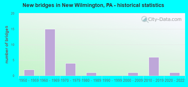
- New bridges - historical statistics
- 21950-1959
- 151960-1969
- 41970-1979
- 11980-1989
- 12000-2009
- 62010-2019
- 12020-2022


- Bridge Condition - Deck
- 33.3%Very good
- 27.8%Good
- 27.8%Satisfactory
- 5.6%Fair
- 5.6%Poor

- Bridge Condition - Superstructure
- 5.6%Excellent
- 16.7%Very good
- 33.3%Good
- 22.2%Satisfactory
- 22.2%Fair

- Bridge Condition - Substructure
- 11.1%Excellent
- 16.7%Very good
- 16.7%Good
- 38.9%Satisfactory
- 16.7%Fair

- Bridge Condition - Channel
- 5.3%Excellent
- 26.3%Very good
- 21.1%Good
- 15.8%Satisfactory
- 21.1%Fair
- 10.5%Poor

- Bridge Condition - Culverts
- 16.7%Very good
- 33.3%Good
- 16.7%Satisfactory
- 33.3%Fair
Find on map >> Show street view
Structure Number: 22206, Location: 1.0 MI N OF MITCHELL ROAD (Lat: 41.081972, Lng: -80.379647), Route carried "on" structure: Interstate 376, Year Built: 1973, Status: Open, Structure Length: 3.99m (13.09ft), Average Daily Traffic: 7,445 (year 2021), Truck Traffic: 22%, Average Future Daily Traffic: 8,831 (year 2032), Design Load: HS 20, Features Intersected: TWP 593 NASHUA ROAD
Minimum Vertical Clearance: 30+ m (98+ ft), Kilometerpoint: 5.940, Lanes on structure: 2, Lanes under structure: 2, Base Highway Network: Yes, Owner: State Highway Agency, Approaching Roadway Width: 13.7m (44.9ft), Skew: 11 degrees, Material/Design: Prestressed concrete, Design/Construction: Box Beam or Girders - Single/Spread, Number Of Spans In Main Unit: 3, Length of Maximum Span: 18.6m (61.0ft), Curb or Sidewalk Widths: Left: 0.2m (0.7ft), Right: 0.2m (0.7ft), Curb-To-Curb Width: 11.9m (39.0ft), Out-to-Out Width: 13.2m (43.3ft)
Condition: Deck: Very good, Superstructure: Good, Substructure: Good, Operating Rating: 67.1 metric tons, Method Used To Determine Operating Rating: Load Factor (LF), Inventory Rating: 33.6 metric tons, Method Used To Determine Inventory Rating: Load Factor (LF), Structural Evaluation: Better than present minimum criteria, Deck Geometry: Equal to present minimum criteria, Underclear: Equal to present minimum criteria, Approach Roadway Alignment: Equal to present desirable criteria, Length Of Structure Improvement: 4.80m (15.75ft), Designated Inspection Frequency: Every 24 months, Inspection Date: June 2021, Bridge Improvement Cost: $18,000, Roadway Improvement Cost: $71,000, Total Project Cost: $240,000, Deck Structure Type: Concrete Cast-file-Place, Wearing Surface/Protective System: Wearing Surface: Latex Concrete
Find on map >> Show street view
Structure Number: 22207, Location: 3.3 MI S OF SR 208 (Lat: 41.081906, Lng: -80.379964), Route carried "on" structure: Interstate 376, Year Built: 1973, Status: Open, Structure Length: 3.99m (13.09ft), Average Daily Traffic: 7,370 (year 2021), Truck Traffic: 19%, Average Future Daily Traffic: 9,063 (year 2032), Design Load: HS 20, Features Intersected: TWP 593 NASHUA ROAD, Facility Carried by Structure: BEAVER VALLEY EXPY
Minimum Vertical Clearance: 30+ m (98+ ft), Kilometerpoint: 5.977, Lanes on structure: 2, Lanes under structure: 2, Base Highway Network: Yes, Owner: State Highway Agency, Approaching Roadway Width: 13.7m (44.9ft), Skew: 11 degrees, Material/Design: Prestressed concrete, Design/Construction: Box Beam or Girders - Single/Spread, Number Of Spans In Main Unit: 3, Length of Maximum Span: 18.6m (61.0ft), Curb or Sidewalk Widths: Left: 0.2m (0.7ft), Right: 0.2m (0.7ft), Curb-To-Curb Width: 11.9m (39.0ft), Out-to-Out Width: 13.2m (43.3ft)
Condition: Deck: Very good, Superstructure: Good, Substructure: Good, Operating Rating: 62.6 metric tons, Method Used To Determine Operating Rating: Load Factor (LF), Inventory Rating: 35.4 metric tons, Method Used To Determine Inventory Rating: Load Factor (LF), Structural Evaluation: Better than present minimum criteria, Deck Geometry: Equal to present minimum criteria, Underclear: Equal to present minimum criteria, Approach Roadway Alignment: Equal to present desirable criteria, Length Of Structure Improvement: 4.80m (15.75ft), Designated Inspection Frequency: Every 24 months, Inspection Date: June 2021, Bridge Improvement Cost: $15,000, Roadway Improvement Cost: $44,000, Total Project Cost: $203,000, Deck Structure Type: Concrete Cast-file-Place, Wearing Surface/Protective System: Wearing Surface: Latex Concrete
Find on map >> Show street view
Structure Number: 2227, Location: 1/2 MI.EAST OF SR 0158 (Lat: 41.122692, Lng: -80.320931), Route carried "on" structure: State highway 208, Year Built: 1962, Status: Open, Structure Length: 3.44m (11.29ft), Average Daily Traffic: 3,894 (year 2022), Truck Traffic: 3%, Average Future Daily Traffic: 4,809 (year 2032), Design Load: HS 20, Features Intersected: OVER LITTLE NESHANNOCK C, Facility Carried by Structure: MARKET ST
Minimum Vertical Clearance: 30+ m (98+ ft), Kilometerpoint: 17.426, Lanes on structure: 2, Base Highway Network: Yes, Owner: State Highway Agency, Approaching Roadway Width: 10.4m (34.1ft), Material/Design: Prestressed concrete, Design/Construction: Box Beam or Girders - Multiple, Number Of Spans In Main Unit: 2, Length of Maximum Span: 17.1m (56.1ft), Curb or Sidewalk Widths: Left: 0.5m (1.6ft), Right: 1.5m (4.9ft), Curb-To-Curb Width: 11.6m (38.1ft), Out-to-Out Width: 13.9m (45.6ft)
Condition: Deck: Satisfactory, Superstructure: Satisfactory, Substructure: Satisfactory, Channel: Poor, Operating Rating: 74.4 metric tons, Method Used To Determine Operating Rating: Load Factor (LF), Inventory Rating: 27.2 metric tons, Method Used To Determine Inventory Rating: Load Factor (LF), Structural Evaluation: Equal to present minimum criteria, Deck Geometry: Somewhat better than minimum adequacy, Waterway Adequacy: Equal to present minimum criteria, Approach Roadway Alignment: Equal to present desirable criteria, Length Of Structure Improvement: 3.40m (11.15ft), Designated Inspection Frequency: Every 24 months, Inspection Date: September 2020, Deck Structure Type: Concrete Cast-file-Place, Wearing Surface/Protective System: Wearing Surface: Bituminous
Find on map >> Show street view
Structure Number: 22271, Location: 3/4 MI.EAST OF SR 0158 (Lat: 41.122622, Lng: -80.319278), Route carried "on" structure: State highway 208, Year Built: 1962, Status: Open, Structure Length: 0.82m (2.69ft), Average Daily Traffic: 3,894 (year 2022), Truck Traffic: 3%, Average Future Daily Traffic: 4,809 (year 2032), Design Load: HS 20, Features Intersected: BR.LITTLE NESHANNOCK CR., Facility Carried by Structure: MARKET ST
Minimum Vertical Clearance: 30+ m (98+ ft), Kilometerpoint: 17.426, Lanes on structure: 2, Base Highway Network: Yes, Owner: State Highway Agency, Approaching Roadway Width: 7.3m (24.0ft), Skew: 3 degrees, Material/Design: Concrete, Design/Construction: Slab, Number Of Spans In Main Unit: 1, Length of Maximum Span: 7.3m (24.0ft), Curb or Sidewalk Widths: Left: 0.5m (1.6ft), Right: 0.5m (1.6ft), Curb-To-Curb Width: 11.6m (38.1ft), Out-to-Out Width: 13.3m (43.6ft)
Condition: Deck: Satisfactory, Superstructure: Satisfactory, Substructure: Satisfactory, Channel: Poor, Operating Rating: 50.8 metric tons, Method Used To Determine Operating Rating: Load Factor (LF), Inventory Rating: 29.9 metric tons, Method Used To Determine Inventory Rating: Load Factor (LF), Structural Evaluation: Equal to present minimum criteria, Deck Geometry: Somewhat better than minimum adequacy, Waterway Adequacy: Equal to present minimum criteria, Approach Roadway Alignment: Equal to present desirable criteria, Length Of Structure Improvement: 0.80m (2.62ft), Designated Inspection Frequency: Every 24 months, Inspection Date: September 2020, Deck Structure Type: Concrete Cast-file-Place, Wearing Surface/Protective System: Wearing Surface: Bituminous
Find on map >> Show street view
Structure Number: 22568, Location: 037022 WILMINGTON TWP (Lat: 41.082439, Lng: -80.306631), Route carried "on" structure: City street , Year Built: 2001, Status: Open, Structure Length: 3.60m (11.81ft), Average Daily Traffic: 200 (year 2005), Truck Traffic: 1%, Average Future Daily Traffic: 200 (year 2025), Design Load: HS 25 or greater, Features Intersected: NESHANNOCK CREEK, Facility Carried by Structure: LAKEWOOD RD
Minimum Vertical Clearance: 30+ m (98+ ft), Kilometerpoint: 0.000, Lanes on structure: 2, Owner: County Highway Agency, Approaching Roadway Width: 6.7m (22.0ft), Material/Design: Prestressed concrete continuous, Design/Construction: Box Beam or Girders - Multiple, Number Of Spans In Main Unit: 2, Length of Maximum Span: 16.8m (55.1ft), Curb-To-Curb Width: 8.0m (26.2ft), Out-to-Out Width: 8.9m (29.2ft)
Condition: Deck: Good, Superstructure: Good, Substructure: Good, Channel: Good, Operating Rating: 62.6 metric tons, Method Used To Determine Operating Rating: Load Factor (LF), Inventory Rating: 37.2 metric tons, Method Used To Determine Inventory Rating: Load Factor (LF), Structural Evaluation: Better than present minimum criteria, Deck Geometry: Somewhat better than minimum adequacy, Waterway Adequacy: Equal to present desirable criteria, Approach Roadway Alignment: High priority of corrective action, Length Of Structure Improvement: 3.60m (11.81ft), Designated Inspection Frequency: Every 24 months, Inspection Date: July 2021, Deck Structure Type: Wood or Timber, Wearing Surface/Protective System: Wearing Surface: Monolithic Concrete, Deck Protection: Epoxy Coated Reinforcing
Find on map >> Show street view
Structure Number: 25782, Location: LACKAWANNOCK TOWNSHIP (Lat: 41.184392, Lng: -80.323789), Route carried "on" structure: Interstate 80, Year Built: 1965, Status: Open, Structure Length: 0.64m (2.10ft), Average Daily Traffic: 15,595 (year 2021), Truck Traffic: 37%, Average Future Daily Traffic: 16,802 (year 2032), Design Load: HS 20+Mod, Features Intersected: OVER HARTHEGIG RUN
Minimum Vertical Clearance: 30+ m (98+ ft), Kilometerpoint: 16.119, Lanes on structure: 2, Base Highway Network: Yes, Owner: State Highway Agency, Approaching Roadway Width: 11.6m (38.1ft), Skew: 14 degrees, Material/Design: Concrete, Design/Construction: Culvert, Number Of Spans In Main Unit: 1, Length of Maximum Span: 6.4m (21.0ft)
Condition: Channel: Fair, Culverts: Fair, Operating Rating: 81.6 metric tons, Method Used To Determine Operating Rating: Load Factor (LF), Inventory Rating: 49.0 metric tons, Method Used To Determine Inventory Rating: Load Factor (LF), Structural Evaluation: Somewhat better than minimum adequacy, Waterway Adequacy: Superior to present desirable criteria, Approach Roadway Alignment: Equal to present desirable criteria, Length Of Structure Improvement: 1.20m (3.94ft), Designated Inspection Frequency: Every 24 months, Inspection Date: December 2019, Bridge Improvement Cost: $28,000, Roadway Improvement Cost: $82,000, Total Project Cost: $376,000
Find on map >> Show street view
Structure Number: 25783, Location: LACKAWANNOCK TOWNSHIP (Lat: 41.181639, Lng: -80.319964), Route carried "on" structure: Interstate 80, Year Built: 1965, Status: Open, Structure Length: 0.64m (2.10ft), Average Daily Traffic: 15,835 (year 2021), Truck Traffic: 32%, Average Future Daily Traffic: 17,657 (year 2032), Design Load: HS 20+Mod, Features Intersected: OVER HARTHEGIG RUN
Minimum Vertical Clearance: 30+ m (98+ ft), Kilometerpoint: 16.877, Lanes on structure: 2, Base Highway Network: Yes, Owner: State Highway Agency, Approaching Roadway Width: 11.6m (38.1ft), Skew: 14 degrees, Material/Design: Concrete, Design/Construction: Culvert, Number Of Spans In Main Unit: 1, Length of Maximum Span: 6.4m (21.0ft)
Condition: Channel: Fair, Culverts: Fair, Inventory Rating: 64.4 metric tons, Method Used To Determine Inventory Rating: Load Factor (LF), Structural Evaluation: Somewhat better than minimum adequacy, Waterway Adequacy: Superior to present desirable criteria, Approach Roadway Alignment: Equal to present desirable criteria, Length Of Structure Improvement: 1.20m (3.94ft), Designated Inspection Frequency: Every 24 months, Inspection Date: December 2019, Bridge Improvement Cost: $26,000, Roadway Improvement Cost: $77,000, Total Project Cost: $353,000
Find on map >> Show street view
Structure Number: 25784, Location: LACKAWANNOCK TOWNSHIP (Lat: 41.181075, Lng: -80.309292), Route carried "on" structure: Interstate 80, Year Built: 1965, Year Reconstructed: 1994, Status: Open, Structure Length: 6.46m (21.19ft), Average Daily Traffic: 15,835 (year 2021), Truck Traffic: 32%, Average Future Daily Traffic: 17,657 (year 2032), Design Load: HS 20+Mod, Features Intersected: OVER LIT.NESHANNOCK CK
Minimum Vertical Clearance: 30+ m (98+ ft), Kilometerpoint: 17.706, Lanes on structure: 2, Base Highway Network: Yes, Owner: State Highway Agency, Approaching Roadway Width: 11.6m (38.1ft), Skew: 10 degrees, Material/Design: Prestressed concrete, Design/Construction: Stringer/Multi-beam, Number Of Spans In Main Unit: 3, Length of Maximum Span: 24.7m (81.0ft), Curb or Sidewalk Widths: Left: 0.2m (0.7ft), Right: 0.2m (0.7ft), Curb-To-Curb Width: 10.4m (34.1ft), Out-to-Out Width: 11.4m (37.4ft)
Condition: Deck: Good, Superstructure: Satisfactory, Substructure: Satisfactory, Channel: Very good, Operating Rating: 89.8 metric tons, Method Used To Determine Operating Rating: Load Factor (LF), Inventory Rating: 38.1 metric tons, Method Used To Determine Inventory Rating: Load Factor (LF), Structural Evaluation: Equal to present minimum criteria, Deck Geometry: Meets minimum limits, Waterway Adequacy: Superior to present desirable criteria, Approach Roadway Alignment: Equal to present desirable criteria, Length Of Structure Improvement: 7.40m (24.28ft), Designated Inspection Frequency: Every 48 months, Inspection Date: April 2020, Bridge Improvement Cost: $14,000, Roadway Improvement Cost: $40,000, Total Project Cost: $183,000, Deck Structure Type: Concrete Cast-file-Place, Wearing Surface/Protective System: Wearing Surface: Bituminous, Membrane: Preformed Fabric, Deck Protection: Galvanized Reinforcing
Find on map >> Show street view
Structure Number: 25785, Location: EAST LACKAWANNOCK TWP. (Lat: 41.182117, Lng: -80.306422), Route carried "on" structure: Interstate 80, Year Built: 1965, Year Reconstructed: 1993, Status: Open, Structure Length: 3.69m (12.11ft), Average Daily Traffic: 15,835 (year 2021), Truck Traffic: 32%, Average Future Daily Traffic: 17,657 (year 2032), Design Load: HS 20, Features Intersected: OVER SR 3007,MRCR-PLSKI
Minimum Vertical Clearance: 30+ m (98+ ft), Kilometerpoint: 17.706, Lanes on structure: 2, Lanes under structure: 2, Base Highway Network: Yes, Owner: State Highway Agency, Approaching Roadway Width: 11.6m (38.1ft), Skew: 12 degrees, Material/Design: Prestressed concrete, Design/Construction: Box Beam or Girders - Single/Spread, Number Of Spans In Main Unit: 3, Length of Maximum Span: 13.1m (43.0ft), Curb or Sidewalk Widths: Left: 0.2m (0.7ft), Right: 0.2m (0.7ft), Curb-To-Curb Width: 12.8m (42.0ft), Out-to-Out Width: 13.9m (45.6ft)
Condition: Deck: Good, Superstructure: Fair, Substructure: Fair, Operating Rating: 89.8 metric tons, Method Used To Determine Operating Rating: Load Factor (LF), Inventory Rating: 49.0 metric tons, Method Used To Determine Inventory Rating: Load Factor (LF), Structural Evaluation: Somewhat better than minimum adequacy, Deck Geometry: Equal to present desirable criteria, Underclear: Somewhat better than minimum adequacy, Approach Roadway Alignment: Equal to present desirable criteria, Length Of Structure Improvement: 4.60m (15.09ft), Designated Inspection Frequency: Every 24 months, Inspection Date: April 2020, Bridge Improvement Cost: $20,000, Roadway Improvement Cost: $59,000, Total Project Cost: $271,000, Deck Structure Type: Concrete Cast-file-Place, Wearing Surface/Protective System: Wearing Surface: Bituminous, Membrane: Preformed Fabric, Deck Protection: Epoxy Coated Reinforcing
Find on map >> Show street view
Structure Number: 25786, Location: LACKAWANNOCK TOWNSHIP (Lat: 41.181353, Lng: -80.309442), Route carried "on" structure: Interstate 80, Year Built: 1966, Year Reconstructed: 1994, Status: Open, Structure Length: 6.46m (21.19ft), Average Daily Traffic: 15,595 (year 2021), Truck Traffic: 37%, Average Future Daily Traffic: 16,802 (year 2032), Design Load: HS 20+Mod, Features Intersected: OVER LIT.NESHANNOCK CK
Minimum Vertical Clearance: 30+ m (98+ ft), Kilometerpoint: 17.711, Lanes on structure: 2, Base Highway Network: Yes, Owner: State Highway Agency, Approaching Roadway Width: 11.6m (38.1ft), Skew: 10 degrees, Material/Design: Prestressed concrete, Design/Construction: Stringer/Multi-beam, Number Of Spans In Main Unit: 3, Length of Maximum Span: 24.7m (81.0ft), Curb or Sidewalk Widths: Left: 0.2m (0.7ft), Right: 0.2m (0.7ft), Curb-To-Curb Width: 10.4m (34.1ft), Out-to-Out Width: 11.4m (37.4ft)
Condition: Deck: Good, Superstructure: Satisfactory, Substructure: Satisfactory, Channel: Excellent, Operating Rating: 89.8 metric tons, Method Used To Determine Operating Rating: Load Factor (LF), Inventory Rating: 38.1 metric tons, Method Used To Determine Inventory Rating: Load Factor (LF), Structural Evaluation: Equal to present minimum criteria, Deck Geometry: Meets minimum limits, Waterway Adequacy: Superior to present desirable criteria, Approach Roadway Alignment: Equal to present desirable criteria, Length Of Structure Improvement: 7.40m (24.28ft), Designated Inspection Frequency: Every 48 months, Inspection Date: April 2020, Bridge Improvement Cost: $14,000, Roadway Improvement Cost: $40,000, Total Project Cost: $183,000, Deck Structure Type: Concrete Cast-file-Place, Wearing Surface/Protective System: Wearing Surface: Bituminous, Membrane: Preformed Fabric, Deck Protection: Epoxy Coated Reinforcing
Find on map >> Show street view
Structure Number: 25787, Location: EAST LACKAWANNOCK TWP. (Lat: 41.182431, Lng: -80.306483), Route carried "on" structure: Interstate 80, Year Built: 1965, Year Reconstructed: 1993, Status: Open, Structure Length: 3.26m (10.70ft), Average Daily Traffic: 15,595 (year 2021), Truck Traffic: 37%, Average Future Daily Traffic: 16,802 (year 2032), Design Load: HS 20, Features Intersected: OVER SR 3007,MRCR-PLSKI
Minimum Vertical Clearance: 30+ m (98+ ft), Kilometerpoint: 17.711, Lanes on structure: 2, Lanes under structure: 2, Base Highway Network: Yes, Owner: State Highway Agency, Approaching Roadway Width: 11.6m (38.1ft), Skew: 12 degrees, Material/Design: Prestressed concrete, Design/Construction: Box Beam or Girders - Single/Spread, Number Of Spans In Main Unit: 3, Length of Maximum Span: 11.0m (36.1ft), Curb or Sidewalk Widths: Left: 0.2m (0.7ft), Right: 0.2m (0.7ft), Curb-To-Curb Width: 12.8m (42.0ft), Out-to-Out Width: 13.9m (45.6ft)
Condition: Deck: Good, Superstructure: Fair, Substructure: Fair, Operating Rating: 57.2 metric tons, Method Used To Determine Operating Rating: Load Factor (LF), Inventory Rating: 32.7 metric tons, Method Used To Determine Inventory Rating: Load Factor (LF), Structural Evaluation: Somewhat better than minimum adequacy, Deck Geometry: Equal to present desirable criteria, Underclear: Somewhat better than minimum adequacy, Approach Roadway Alignment: Equal to present desirable criteria, Length Of Structure Improvement: 4.10m (13.45ft), Designated Inspection Frequency: Every 24 months, Inspection Date: April 2020, Deck Structure Type: Concrete Cast-file-Place, Wearing Surface/Protective System: Wearing Surface: Bituminous, Membrane: Preformed Fabric, Deck Protection: Epoxy Coated Reinforcing
Find on map >> Show street view
Structure Number: 2582, Location: WILMINGTON TOWNSHIP (Lat: 41.152314, Lng: -80.308089), Route carried "on" structure: State highway 158, Year Built: 1984, Status: Open, Structure Length: 0.67m (2.20ft), Average Daily Traffic: 1,684 (year 2022), Truck Traffic: 7%, Average Future Daily Traffic: 1,888 (year 2032), Design Load: HS 20, Features Intersected: OVER NESHANNOCK CREEK TR
Minimum Vertical Clearance: 30+ m (98+ ft), Kilometerpoint: 3.381, Lanes on structure: 2, Owner: State Highway Agency, Approaching Roadway Width: 8.2m (26.9ft), Material/Design: Steel, Design/Construction: Culvert, Number Of Spans In Main Unit: 1, Length of Maximum Span: 6.7m (22.0ft)
Condition: Channel: Fair, Culverts: Good, Operating Rating: 49.0 metric tons, Method Used To Determine Operating Rating: Field evaluation and documented engineering judgment, Inventory Rating: 32.7 metric tons, Method Used To Determine Inventory Rating: Field evaluation and documented engineering judgment, Structural Evaluation: Better than present minimum criteria, Waterway Adequacy: Superior to present desirable criteria, Approach Roadway Alignment: Equal to present desirable criteria, Length Of Structure Improvement: 1.50m (4.92ft), Designated Inspection Frequency: Every 24 months, Inspection Date: April 2020
Find on map >> Show street view
Structure Number: 25983, Location: WILMINGTON TOWNSHIP (Lat: 41.151639, Lng: -80.365661), Route carried "on" structure: State highway , Year Built: 1962, Status: Open, Structure Length: 1.92m (6.30ft), Average Daily Traffic: 637 (year 2021), Truck Traffic: 6%, Average Future Daily Traffic: 532 (year 2032), Design Load: HS 20+Mod, Features Intersected: OVER W BRANCH NESHANNOCK, Facility Carried by Structure: SR 3007,PLSKI-MRCR
Minimum Vertical Clearance: 30+ m (98+ ft), Kilometerpoint: 4.978, Lanes on structure: 2, Owner: State Highway Agency, Approaching Roadway Width: 6.4m (21.0ft), Material/Design: Prestressed concrete, Design/Construction: Box Beam or Girders - Single/Spread, Number Of Spans In Main Unit: 1, Length of Maximum Span: 18.6m (61.0ft), Curb or Sidewalk Widths: Left: 0.5m (1.6ft), Right: 0.5m (1.6ft), Curb-To-Curb Width: 8.6m (28.2ft), Out-to-Out Width: 10.2m (33.5ft)
Condition: Deck: Satisfactory, Superstructure: Good, Substructure: Satisfactory, Channel: Satisfactory, Operating Rating: 81.6 metric tons, Method Used To Determine Operating Rating: Load Factor (LF), Inventory Rating: 31.8 metric tons, Method Used To Determine Inventory Rating: Load Factor (LF), Structural Evaluation: Equal to present minimum criteria, Deck Geometry: Somewhat better than minimum adequacy, Waterway Adequacy: Equal to present desirable criteria, Approach Roadway Alignment: Equal to present desirable criteria, Length Of Structure Improvement: 2.60m (8.53ft), Designated Inspection Frequency: Every 24 months, Inspection Date: August 2020, Bridge Improvement Cost: $4,000, Roadway Improvement Cost: $12,000, Total Project Cost: $56,000, Deck Structure Type: Concrete Cast-file-Place, Wearing Surface/Protective System: Wearing Surface: Bituminous
Find on map >> Show street view
Structure Number: 25986, Location: EAST LACKAWANNOCK TWP. (Lat: 41.180575, Lng: -80.308856), Route carried "on" structure: State highway , Year Built: 1964, Status: Open, Structure Length: 1.62m (5.31ft), Average Daily Traffic: 637 (year 2021), Truck Traffic: 6%, Average Future Daily Traffic: 532 (year 2032), Design Load: HS 20, Features Intersected: OVER LT NESHANNOCK CK, Facility Carried by Structure: SR 3007,PLSKI-MRCR
Minimum Vertical Clearance: 30+ m (98+ ft), Kilometerpoint: 11.562, Lanes on structure: 2, Owner: State Highway Agency, Approaching Roadway Width: 6.4m (21.0ft), Material/Design: Prestressed concrete, Design/Construction: Box Beam or Girders - Single/Spread, Number Of Spans In Main Unit: 1, Length of Maximum Span: 15.8m (51.8ft), Curb-To-Curb Width: 9.1m (29.9ft), Out-to-Out Width: 10.8m (35.4ft)
Condition: Deck: Satisfactory, Superstructure: Good, Substructure: Satisfactory, Channel: Satisfactory, Operating Rating: 76.2 metric tons, Method Used To Determine Operating Rating: Load Factor (LF), Inventory Rating: 30.8 metric tons, Method Used To Determine Inventory Rating: Load Factor (LF), Structural Evaluation: Equal to present minimum criteria, Deck Geometry: Equal to present minimum criteria, Waterway Adequacy: Better than present minimum criteria, Approach Roadway Alignment: Equal to present desirable criteria, Length Of Structure Improvement: 1.60m (5.25ft), Designated Inspection Frequency: Every 24 months, Inspection Date: November 2021, Deck Structure Type: Concrete Cast-file-Place, Wearing Surface/Protective System: Wearing Surface: Bituminous
Find on map >> Show street view
Structure Number: 25996, Location: LACKAWANNOCK TOWNSHIP (Lat: 41.138417, Lng: -80.321697), Route carried "on" structure: State highway , Year Built: 1965, Status: Open, Structure Length: 7.47m (24.51ft), Average Daily Traffic: 422 (year 2022), Truck Traffic: 9%, Average Future Daily Traffic: 626 (year 2032), Design Load: HS 20, Features Intersected: OVER SR 80,EB/WB, Facility Carried by Structure: SR 3013 ORCHARD RD
Minimum Vertical Clearance: 30+ m (98+ ft), Kilometerpoint: 0.016, Lanes on structure: 2, Lanes under structure: 8, Owner: State Highway Agency, Approaching Roadway Width: 5.5m (18.0ft), Skew: 2 degrees, Material/Design: Prestressed concrete, Design/Construction: Box Beam or Girders - Single/Spread, Number Of Spans In Main Unit: 5, Length of Maximum Span: 18.3m (60.0ft), Curb or Sidewalk Widths: Left: 0.4m (1.3ft), Right: 0.4m (1.3ft), Curb-To-Curb Width: 8.5m (27.9ft), Out-to-Out Width: 10.4m (34.1ft)
Condition: Deck: Fair, Superstructure: Fair, Substructure: Satisfactory, Operating Rating: 61.7 metric tons, Method Used To Determine Operating Rating: Load Factor (LF), Inventory Rating: 27.2 metric tons, Method Used To Determine Inventory Rating: Load Factor (LF), Structural Evaluation: Somewhat better than minimum adequacy, Deck Geometry: Somewhat better than minimum adequacy, Underclear: Somewhat better than minimum adequacy, Approach Roadway Alignment: Equal to present desirable criteria, Length Of Structure Improvement: 25.30m (83.01ft), Designated Inspection Frequency: Every 24 months, Inspection Date: August 2021, Bridge Improvement Cost: $111,000, Roadway Improvement Cost: $328,000, Total Project Cost: $1,502,000, Deck Structure Type: Concrete Cast-file-Place, Wearing Surface/Protective System: Wearing Surface: Bituminous
Find on map >> Show street view
Structure Number: 26295, Location: BEND RD. WILMINGTON TWP. (Lat: 41.139831, Lng: -80.341233), Route carried "on" structure: City street 7229, Year Built: 1956, Status: Open, Structure Length: 1.98m (6.50ft), Average Daily Traffic: 574 (year 2018), Truck Traffic: 4%, Average Future Daily Traffic: 800 (year 2038), Design Load: HS 20, Features Intersected: OVER LT.NESHANNOCK W. BR, Facility Carried by Structure: BRIDGE 2904,T-546
Minimum Vertical Clearance: 30+ m (98+ ft), Kilometerpoint: 0.000, Lanes on structure: 2, Owner: County Highway Agency, Approaching Roadway Width: 6.7m (22.0ft), Material/Design: Steel, Design/Construction: Stringer/Multi-beam, Number Of Spans In Main Unit: 1, Length of Maximum Span: 18.9m (62.0ft), Curb-To-Curb Width: 7.3m (24.0ft), Out-to-Out Width: 7.6m (24.9ft)
Condition: Deck: Poor, Superstructure: Fair, Substructure: Fair, Channel: Good, Operating Rating: 78.0 metric tons, Method Used To Determine Operating Rating: Load Factor (LF), Inventory Rating: 46.3 metric tons, Method Used To Determine Inventory Rating: Load Factor (LF), Structural Evaluation: Somewhat better than minimum adequacy, Deck Geometry: Meets minimum limits, Waterway Adequacy: Equal to present desirable criteria, Approach Roadway Alignment: Equal to present desirable criteria, Length Of Structure Improvement: 2.00m (6.56ft), Designated Inspection Frequency: Every 24 months, Inspection Date: August 2020, Total Project Cost: $1,482,000 ( Estimate for 2014), Deck Structure Type: Concrete Cast-file-Place
Find on map >> Show street view
Structure Number: 26296, Location: NO. 8 RD.,WILMINGTON TWP. (Lat: 41.146786, Lng: -80.325083), Route carried "on" structure: City street 7229, Year Built: 1956, Status: Open, Structure Length: 0.73m (2.40ft), Average Daily Traffic: 141 (year 2018), Truck Traffic: 4%, Average Future Daily Traffic: 200 (year 2038), Design Load: HS 20, Features Intersected: OVER LT. NESHANNOCK CK.B, Facility Carried by Structure: BRIDGE 2903,T-548
Minimum Vertical Clearance: 30+ m (98+ ft), Kilometerpoint: 0.000, Lanes on structure: 2, Owner: County Highway Agency, Approaching Roadway Width: 6.7m (22.0ft), Material/Design: Concrete, Design/Construction: Culvert, Number Of Spans In Main Unit: 1, Length of Maximum Span: 6.7m (22.0ft), Curb-To-Curb Width: 6.7m (22.0ft), Out-to-Out Width: 7.9m (25.9ft)
Condition: Channel: Fair, Culverts: Good, Operating Rating: 89.8 metric tons, Method Used To Determine Operating Rating: Load Factor (LF), Inventory Rating: 83.5 metric tons, Method Used To Determine Inventory Rating: Load Factor (LF), Structural Evaluation: Better than present minimum criteria, Deck Geometry: Meets minimum limits, Waterway Adequacy: Equal to present desirable criteria, Approach Roadway Alignment: Equal to present desirable criteria, Length Of Structure Improvement: 0.70m (2.30ft), Designated Inspection Frequency: Every 24 months, Inspection Date: August 2020
Find on map >> Show street view
Structure Number: 46213, Location: WILMINGTON TOWNSHIP (Lat: 41.137094, Lng: -80.319417), Route carried "on" structure: State highway 158, Year Built: 2010, Status: Open, Structure Length: 2.74m (8.99ft), Average Daily Traffic: 2,571 (year 2022), Truck Traffic: 8%, Average Future Daily Traffic: 2,834 (year 2032), Design Load: HL 93, Features Intersected: LITTLE NESHANNOCK CREEK
Minimum Vertical Clearance: 30+ m (98+ ft), Kilometerpoint: 1.067, Lanes on structure: 2, Owner: State Highway Agency, Approaching Roadway Width: 6.4m (21.0ft), Skew: 2 degrees, Material/Design: Prestressed concrete, Design/Construction: Box Beam or Girders - Single/Spread, Number Of Spans In Main Unit: 1, Length of Maximum Span: 26.5m (86.9ft), Curb or Sidewalk Widths: Left: 0.2m (0.7ft), Right: 0.2m (0.7ft), Curb-To-Curb Width: 8.5m (27.9ft), Out-to-Out Width: 9.6m (31.5ft)
Condition: Deck: Very good, Superstructure: Excellent, Substructure: Excellent, Channel: Very good, Operating Rating: 77.1 metric tons, Method Used To Determine Operating Rating: Load and Resistance Factor (LRFR), Inventory Rating: 37.2 metric tons, Method Used To Determine Inventory Rating: Load and Resistance Factor (LRFR), Structural Evaluation: Superior to present desirable criteria, Deck Geometry: Meets minimum limits, Waterway Adequacy: Equal to present desirable criteria, Approach Roadway Alignment: Equal to present desirable criteria, Designated Inspection Frequency: Every 48 months, Inspection Date: May 2020, Deck Structure Type: Concrete Cast-file-Place, Wearing Surface/Protective System: Wearing Surface: Monolithic Concrete, Deck Protection: Epoxy Coated Reinforcing
Find on map >> Show street view
Structure Number: 46308, Location: WILMINGTON TWP (Lat: 41.138392, Lng: -80.321347), Route carried "on" structure: State highway , Year Built: 2010, Status: Open, Structure Length: 1.65m (5.41ft), Average Daily Traffic: 422 (year 2022), Truck Traffic: 9%, Average Future Daily Traffic: 626 (year 2032), Design Load: HL 93, Features Intersected: TR LITTLE NESHANNOCK CK, Facility Carried by Structure: SR 3013 Orchard Rd
Minimum Vertical Clearance: 30+ m (98+ ft), Kilometerpoint: 0.000, Lanes on structure: 2, Owner: State Highway Agency, Approaching Roadway Width: 7.3m (24.0ft), Skew: 2 degrees, Material/Design: Prestressed concrete, Design/Construction: Box Beam or Girders - Multiple, Number Of Spans In Main Unit: 1, Length of Maximum Span: 15.2m (49.9ft), Curb or Sidewalk Widths: Left: 0.2m (0.7ft), Right: 0.2m (0.7ft), Curb-To-Curb Width: 7.5m (24.6ft), Out-to-Out Width: 8.5m (27.9ft)
Condition: Deck: Satisfactory, Superstructure: Very good, Substructure: Very good, Channel: Good, Operating Rating: 58.1 metric tons, Method Used To Determine Operating Rating: Load and Resistance Factor (LRFR), Inventory Rating: 42.6 metric tons, Method Used To Determine Inventory Rating: Load and Resistance Factor (LRFR), Structural Evaluation: Equal to present desirable criteria, Deck Geometry: Meets minimum limits, Waterway Adequacy: Better than present minimum criteria, Approach Roadway Alignment: Better than present minimum criteria, Designated Inspection Frequency: Every 48 months, Inspection Date: Febuary 2021, Deck Structure Type: Concrete Cast-file-Place, Wearing Surface/Protective System: Wearing Surface: Monolithic Concrete, Deck Protection: Epoxy Coated Reinforcing
Find on map >> Show street view
Structure Number: 47021, Location: WILMINGTON TWP (Lat: 41.135914, Lng: -80.320869), Route carried "on" structure: State highway 158, Year Built: 2011, Status: Open, Structure Length: 2.74m (8.99ft), Average Daily Traffic: 2,571 (year 2022), Truck Traffic: 8%, Average Future Daily Traffic: 2,834 (year 2032), Design Load: HL 93, Features Intersected: W BR LITTLE NESHANNOCK C
Minimum Vertical Clearance: 30+ m (98+ ft), Kilometerpoint: 1.067, Lanes on structure: 2, Owner: State Highway Agency, Approaching Roadway Width: 8.2m (26.9ft), Skew: 3 degrees, Material/Design: Prestressed concrete, Design/Construction: Box Beam or Girders - Single/Spread, Number Of Spans In Main Unit: 1, Length of Maximum Span: 26.5m (86.9ft), Curb or Sidewalk Widths: Left: 0.2m (0.7ft), Right: 0.2m (0.7ft), Curb-To-Curb Width: 8.5m (27.9ft), Out-to-Out Width: 9.6m (31.5ft)
Condition: Deck: Very good, Superstructure: Good, Substructure: Excellent, Channel: Very good, Operating Rating: 70.0 metric tons, Method Used To Determine Operating Rating: Assigned ratings based on Load and Resistance Factor Design (LRFD) reported by rating factor (RF) using HL93 loadings, Inventory Rating: 34.0 metric tons, Method Used To Determine Inventory Rating: Assigned ratings based on Load and Resistance Factor Design (LRFD) reported by rating factor (RF) using HL93 loadings, Structural Evaluation: Better than present minimum criteria, Deck Geometry: Meets minimum limits, Waterway Adequacy: Equal to present desirable criteria, Approach Roadway Alignment: Equal to present desirable criteria, Designated Inspection Frequency: Every 48 months, Inspection Date: April 2020, Deck Structure Type: Concrete Cast-file-Place, Wearing Surface/Protective System: Wearing Surface: Monolithic Concrete, Deck Protection: Epoxy Coated Reinforcing
Find on map >> Show street view
Structure Number: 49142, Location: 0.1 mile from Means Rd (Lat: 41.126103, Lng: -80.311864), Route carried "on" structure: City street /0, Year Built: 2010, Status: Open, Structure Length: 0.70m (2.30ft), Average Daily Traffic: 100 (year 2021), Truck Traffic: 5%, Average Future Daily Traffic: 200 (year 2041), Design Load: HS 20, Features Intersected: Unnamed Tributary, Facility Carried by Structure: Ferris Rd.
Minimum Vertical Clearance: 30+ m (98+ ft), Kilometerpoint: 0.000, Lanes on structure: 2, Owner: Town or Township Highway Agency, Approaching Roadway Width: 5.2m (17.1ft), Material/Design: Concrete, Design/Construction: Culvert, Number Of Spans In Main Unit: 1, Length of Maximum Span: 6.1m (20.0ft), Curb-To-Curb Width: 7.4m (24.3ft), Out-to-Out Width: 8.5m (27.9ft)
Condition: Channel: Good, Culverts: Satisfactory, Operating Rating: 81.6 metric tons, Method Used To Determine Operating Rating: Field evaluation and documented engineering judgment, Inventory Rating: 49.0 metric tons, Method Used To Determine Inventory Rating: Field evaluation and documented engineering judgment, Structural Evaluation: Equal to present minimum criteria, Deck Geometry: Equal to present minimum criteria, Waterway Adequacy: Better than present minimum criteria, Approach Roadway Alignment: Equal to present desirable criteria, Designated Inspection Frequency: Every 24 months, Inspection Date: August 2021
Find on map >> Show street view
Structure Number: 53518, Location: 1/2 MI. S.E. OF SR 1005 (Lat: 41.089567, Lng: -80.315611), Route carried "on" structure: State highway 956, Year Built: 2016, Status: Open, Structure Length: 2.99m (9.81ft), Average Daily Traffic: 965 (year 2022), Truck Traffic: 1%, Average Future Daily Traffic: 1,375 (year 2037), Design Load: HL 93, Features Intersected: LITTLE NESHANNOCK CREEK
Minimum Vertical Clearance: 30+ m (98+ ft), Kilometerpoint: 12.656, Lanes on structure: 2, Owner: State Highway Agency, Maintenance Responsibility: Private, Approaching Roadway Width: 8.5m (27.9ft), Material/Design: Prestressed concrete, Design/Construction: Box Beam or Girders - Multiple, Number Of Spans In Main Unit: 1, Length of Maximum Span: 29.3m (96.1ft), Curb-To-Curb Width: 8.6m (28.2ft), Out-to-Out Width: 9.2m (30.2ft)
Condition: Deck: Very good, Superstructure: Very good, Substructure: Very good, Channel: Very good, Operating Rating: 65.1 metric tons, Method Used To Determine Operating Rating: Assigned ratings based on Load and Resistance Factor Design (LRFD) reported by rating factor (RF) using HL93 loadings, Inventory Rating: 40.8 metric tons, Method Used To Determine Inventory Rating: Assigned ratings based on Load and Resistance Factor Design (LRFD) reported by rating factor (RF) using HL93 loadings, Structural Evaluation: Equal to present desirable criteria, Deck Geometry: Somewhat better than minimum adequacy, Waterway Adequacy: Superior to present desirable criteria, Approach Roadway Alignment: Equal to present desirable criteria, Designated Inspection Frequency: Every 24 months, Inspection Date: September 2020, Deck Structure Type: Concrete Cast-file-Place, Wearing Surface/Protective System: Wearing Surface: Integral Concrete, Deck Protection: Epoxy Coated Reinforcing
Find on map >> Show street view
Structure Number: 539, Location: 1/4 MI. N.E. OF SR 0956 (Lat: 41.094989, Lng: -80.318211), Route carried "on" structure: State highway , Year Built: 2017, Status: Open, Structure Length: 4.85m (15.91ft), Average Daily Traffic: 1,281 (year 2022), Truck Traffic: 7%, Average Future Daily Traffic: 1,387 (year 2037), Design Load: HL 93, Features Intersected: LITTLE NESHANNOCK CREEK, Facility Carried by Structure: HIGHLAND AV.
Minimum Vertical Clearance: 30+ m (98+ ft), Kilometerpoint: 10.239, Lanes on structure: 2, Owner: State Highway Agency, Maintenance Responsibility: Private, Approaching Roadway Width: 6.1m (20.0ft), Skew: 2 degrees, Material/Design: Prestressed concrete continuous, Design/Construction: Box Beam or Girders - Single/Spread, Number Of Spans In Main Unit: 2, Length of Maximum Span: 47.2m (154.9ft), Curb-To-Curb Width: 8.1m (26.6ft), Out-to-Out Width: 8.7m (28.5ft)
Condition: Deck: Very good, Superstructure: Very good, Substructure: Very good, Channel: Satisfactory, Operating Rating: 48.6 metric tons, Method Used To Determine Operating Rating: Assigned ratings based on Load and Resistance Factor Design (LRFD) reported by rating factor (RF) using HL93 loadings, Inventory Rating: 37.6 metric tons, Method Used To Determine Inventory Rating: Assigned ratings based on Load and Resistance Factor Design (LRFD) reported by rating factor (RF) using HL93 loadings, Structural Evaluation: Equal to present desirable criteria, Deck Geometry: Meets minimum limits, Waterway Adequacy: Superior to present desirable criteria, Approach Roadway Alignment: Equal to present desirable criteria, Designated Inspection Frequency: Every 24 months, Inspection Date: September 2021, Deck Structure Type: Concrete Cast-file-Place, Wearing Surface/Protective System: Wearing Surface: Integral Concrete, Deck Protection: Epoxy Coated Reinforcing
Find on map >> Show street view
Structure Number: 55811, Location: 60 FT E. OF WEST. DR. ROT (Lat: 41.119194, Lng: -80.327222), Route carried "on" structure: City street , Year Built: 2021, Status: Open, Structure Length: 1.01m (3.31ft), Average Daily Traffic: 300 (year 2014), Truck Traffic: 3%, Average Future Daily Traffic: 300 (year 2034), Design Load: HL 93, Features Intersected: MCCLURES RUN, Facility Carried by Structure: MAPLE STREET EXT.
Minimum Vertical Clearance: 30+ m (98+ ft), Kilometerpoint: 0.000, Lanes on structure: 2, Owner: City or Municipal Highway Agency, Approaching Roadway Width: 5.2m (17.1ft), Skew: 9 degrees, Material/Design: Concrete, Design/Construction: Culvert, Number Of Spans In Main Unit: 1, Length of Maximum Span: 7.3m (24.0ft), Curb or Sidewalk Widths: Left: 0.6m (2.0ft), Right: 0.6m (2.0ft), Curb-To-Curb Width: 5.2m (17.1ft), Out-to-Out Width: 11.6m (38.1ft)
Condition: Channel: Very good, Culverts: Very good, Operating Rating: 25.6 metric tons, Method Used To Determine Operating Rating: Assigned ratings based on Load and Resistance Factor Design (LRFD) reported by rating factor (RF) using HL93 loadings, Inventory Rating: 19.8 metric tons, Method Used To Determine Inventory Rating: Assigned ratings based on Load and Resistance Factor Design (LRFD) reported by rating factor (RF) using HL93 loadings, Structural Evaluation: Somewhat better than minimum adequacy, Deck Geometry: High priority of replacement, Waterway Adequacy: Better than present minimum criteria, Approach Roadway Alignment: Equal to present desirable criteria, Designated Inspection Frequency: Every 24 months, Inspection Date: November 2021, Wearing Surface/Protective System: Wearing Surface: Bituminous
Find on map >> Show street view
Structure Number: 22206, Location: 1.0 MI N OF MITCHELL ROAD (Lat: 41.081972, Lng: -80.379647), Route carried "under" structure: City street , Year Built: 1973, Structure Length: 0. m, Average Daily Traffic: 310 (year 1993), Truck Traffic: 1%, Features Intersected: TWP 593 NASHUA ROAD, Facility Carried by Structure: SR 0376 WB
Minimum Vertical Clearance: 4.72m (15.49ft), Kilometerpoint: 0.000, Lanes on structure: 2, Lanes under structure: 2, Material/Design: Prestressed concrete, Design/Construction: Box Beam or Girders - Single/Spread, Length of Maximum Span: 18.6m (61.0ft)
Find on map >> Show street view
Structure Number: 22207, Location: 3.3 MI S OF SR 208 (Lat: 41.081906, Lng: -80.379964), Route carried "under" structure: City street , Year Built: 1973, Structure Length: 0. m, Average Daily Traffic: 1 (year 2003), Truck Traffic: 1%, Features Intersected: TWP 593 NASHUA ROAD, Facility Carried by Structure: BEAVER VALLEY EXPY
Minimum Vertical Clearance: 5.05m (16.57ft), Kilometerpoint: 0.000, Lanes on structure: 2, Lanes under structure: 2, Material/Design: Prestressed concrete, Design/Construction: Box Beam or Girders - Single/Spread, Length of Maximum Span: 18.6m (61.0ft)
Find on map >> Show street view
Structure Number: 25785, Location: EAST LACKAWANNOCK TWP. (Lat: 41.182117, Lng: -80.306422), Route carried "under" structure: State highway , Year Built: 1965, Structure Length: 0. m, Average Daily Traffic: 637 (year 2021), Truck Traffic: 6%, Features Intersected: OVER SR 3007,MRCR-PLSKI, Facility Carried by Structure: SR 80,EB
Minimum Vertical Clearance: 4.82m (15.81ft), Kilometerpoint: 11.562, Lanes on structure: 2, Lanes under structure: 2, Material/Design: Prestressed concrete, Design/Construction: Box Beam or Girders - Single/Spread, Length of Maximum Span: 13.1m (43.0ft)
Find on map >> Show street view
Structure Number: 25787, Location: EAST LACKAWANNOCK TWP. (Lat: 41.182431, Lng: -80.306483), Route carried "under" structure: State highway , Year Built: 1965, Structure Length: 0. m, Average Daily Traffic: 637 (year 2021), Truck Traffic: 6%, Features Intersected: OVER SR 3007,MRCR-PLSKI, Facility Carried by Structure: SR 80,WB
Minimum Vertical Clearance: 4.47m (14.67ft), Kilometerpoint: 11.562, Lanes on structure: 2, Lanes under structure: 2, Material/Design: Prestressed concrete, Design/Construction: Box Beam or Girders - Single/Spread, Length of Maximum Span: 11.0m (36.1ft)
Find on map >> Show street view
Structure Number: 25996, Location: LACKAWANNOCK TOWNSHIP (Lat: 41.138417, Lng: -80.321697), Route carried "under" structure: Interstate 80, Year Built: 1965, Structure Length: 0. m, Average Daily Traffic: 15,835 (year 2021), Truck Traffic: 32%, Features Intersected: OVER SR 80,EB/WB, Facility Carried by Structure: SR 3013 ORCHARD RD
Minimum Vertical Clearance: 5.56m (18.24ft), Kilometerpoint: 16.048, Lanes on structure: 2, Lanes under structure: 4, Material/Design: Prestressed concrete, Design/Construction: Box Beam or Girders - Single/Spread, Length of Maximum Span: 18.3m (60.0ft)
Find on map >> Show street view
Structure Number: 25996, Location: LACKAWANNOCK TOWNSHIP (Lat: 41.138417, Lng: -80.321697), Route carried "under" structure: Interstate 80, Year Built: 1965, Structure Length: 0. m, Average Daily Traffic: 15,595 (year 2021), Truck Traffic: 37%, Features Intersected: OVER SR 80,EB/WB, Facility Carried by Structure: SR 3013 ORCHARD RD
Minimum Vertical Clearance: 5.17m (16.96ft), Kilometerpoint: 16.119, Lanes on structure: 2, Lanes under structure: 4, Material/Design: Prestressed concrete, Design/Construction: Box Beam or Girders - Single/Spread, Length of Maximum Span: 18.3m (60.0ft)