Bridge Statistics for New Milford, Pennsylvania (PA)
Condition, Traffic, Stress, Structural Evaluation, Project Costs
- National Bridge Inventory (NBI) Statistics
- 32Number of bridges
- 161ft / 49.1mTotal length
- $5,710,000Total costs
- 155,501Total average daily traffic
- 35,396Total average daily truck traffic
- National Bridge Inventory (NBI) Registered Bridges for New Milford
- No street view available for this location
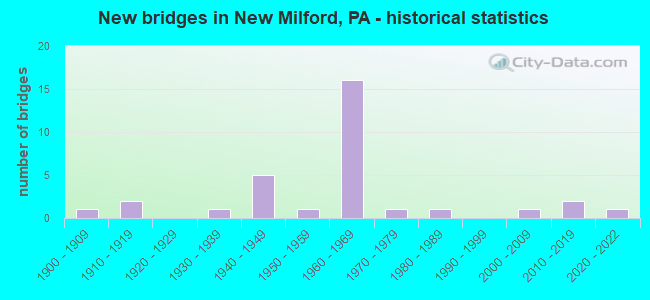
- New bridges - historical statistics
- 11900-1909
- 21910-1919
- 11930-1939
- 51940-1949
- 11950-1959
- 161960-1969
- 11970-1979
- 11980-1989
- 12000-2009
- 22010-2019
- 12020-2022

- Reconstructed bridges - Historical Statistics
- 31970-1979
- 21980-1989
- 21990-1999
- 02000-2009
- 42010-2019


- Bridge Condition - Deck
- 4.2%Excellent
- 20.8%Very good
- 29.2%Good
- 29.2%Satisfactory
- 4.2%Fair
- 8.3%Poor
- 4.2%Imminent failure

- Bridge Condition - Superstructure
- 12.0%Excellent
- 16.0%Very good
- 16.0%Good
- 20.0%Satisfactory
- 12.0%Fair
- 20.0%Poor
- 4.0%Critical

- Bridge Condition - Substructure
- 8.0%Excellent
- 20.0%Good
- 40.0%Satisfactory
- 20.0%Fair
- 12.0%Poor

- Bridge Condition - Channel
- 16.7%Very good
- 22.2%Good
- 22.2%Satisfactory
- 16.7%Fair
- 22.2%Poor
Find on map >> Show street view
Structure Number: 3, Location: 1.25 MI.N. OF MD.LINE (Lat: 39.735781, Lng: -77.297444), Route carried "on" structure: US 15, Year Built: 1963, Year Reconstructed: 1990, Status: Open, Structure Length: 3.08m (10.10ft), Average Daily Traffic: 8,907 (year 2021), Truck Traffic: 21%, Average Future Daily Traffic: 10,516 (year 2032), Design Load: HS 20, Features Intersected: MIDDLE CREEK
Minimum Vertical Clearance: 30+ m (98+ ft), Kilometerpoint: 1.936, Lanes on structure: 2, Base Highway Network: Yes, Owner: State Highway Agency, Approaching Roadway Width: 12.2m (40.0ft), Skew: 10 degrees, Material/Design: Prestressed concrete, Design/Construction: Box Beam or Girders - Single/Spread, Number Of Spans In Main Unit: 2, Length of Maximum Span: 14.6m (47.9ft), Curb or Sidewalk Widths: Left: 0.2m (0.7ft), Right: 0.2m (0.7ft), Curb-To-Curb Width: 12.8m (42.0ft), Out-to-Out Width: 13.9m (45.6ft)
Condition: Deck: Good, Superstructure: Satisfactory, Substructure: Satisfactory, Channel: Satisfactory, Operating Rating: 68.9 metric tons, Method Used To Determine Operating Rating: Load Factor (LF), Inventory Rating: 36.3 metric tons, Method Used To Determine Inventory Rating: Load Factor (LF), Structural Evaluation: Equal to present minimum criteria, Deck Geometry: Equal to present desirable criteria, Waterway Adequacy: Superior to present desirable criteria, Approach Roadway Alignment: Equal to present desirable criteria, Designated Inspection Frequency: Every 24 months, Inspection Date: November 2020, Deck Structure Type: Concrete Cast-file-Place, Wearing Surface/Protective System: Wearing Surface: Monolithic Concrete, Deck Protection: Epoxy Coated Reinforcing
Find on map >> Show street view
Structure Number: 15, Location: 2 MI. E. OF GETTYSBURG (Lat: 39.824722, Lng: -77.198400), Route carried "on" structure: US 15, Year Built: 1963, Status: Open, Structure Length: 1.31m (4.30ft), Average Daily Traffic: 11,478 (year 2022), Truck Traffic: 19%, Average Future Daily Traffic: 14,892 (year 2032), Design Load: HS 20, Features Intersected: PA 116; SR 0116
Minimum Vertical Clearance: 30+ m (98+ ft), Kilometerpoint: 16.108, Lanes on structure: 2, Lanes under structure: 2, Base Highway Network: Yes, Owner: State Highway Agency, Approaching Roadway Width: 12.2m (40.0ft), Skew: 1 degrees, Material/Design: Prestressed concrete, Design/Construction: Box Beam or Girders - Single/Spread, Number Of Spans In Main Unit: 1, Length of Maximum Span: 12.8m (42.0ft), Curb or Sidewalk Widths: Left: 0.2m (0.7ft), Right: 0.2m (0.7ft), Curb-To-Curb Width: 13.1m (43.0ft), Out-to-Out Width: 14.0m (45.9ft)
Condition: Deck: Good, Superstructure: Good, Substructure: Satisfactory, Operating Rating: 59.0 metric tons, Method Used To Determine Operating Rating: Load Factor (LF), Inventory Rating: 35.4 metric tons, Method Used To Determine Inventory Rating: Load Factor (LF), Structural Evaluation: Equal to present minimum criteria, Deck Geometry: Superior to present desirable criteria, Underclear: Meets minimum limits, Approach Roadway Alignment: Equal to present desirable criteria, Designated Inspection Frequency: Every 24 months, Inspection Date: January 2021, Deck Structure Type: Concrete Cast-file-Place, Wearing Surface/Protective System: Wearing Surface: Latex Concrete
Find on map >> Show street view
Structure Number: 28, Location: N OF HEIDLERSBURG (Lat: 39.975356, Lng: -77.127497), Route carried "on" structure: US 15, Year Built: 1967, Year Reconstructed: 2010, Status: Open, Structure Length: 3.32m (10.89ft), Average Daily Traffic: 8,733 (year 2021), Truck Traffic: 21%, Average Future Daily Traffic: 12,305 (year 2032), Design Load: HS 20, Features Intersected: BERMUDIAN CREEK
Minimum Vertical Clearance: 30+ m (98+ ft), Kilometerpoint: 34.136, Lanes on structure: 2, Base Highway Network: Yes, Owner: State Highway Agency, Approaching Roadway Width: 12.5m (41.0ft), Skew: 13 degrees, Material/Design: Prestressed concrete, Design/Construction: Box Beam or Girders - Single/Spread, Number Of Spans In Main Unit: 2, Length of Maximum Span: 16.2m (53.1ft), Curb or Sidewalk Widths: Left: 0.5m (1.6ft), Right: 0.5m (1.6ft), Curb-To-Curb Width: 12.2m (40.0ft), Out-to-Out Width: 13.9m (45.6ft)
Condition: Deck: Satisfactory, Superstructure: Satisfactory, Substructure: Fair, Channel: Good, Operating Rating: 74.4 metric tons, Method Used To Determine Operating Rating: Load Factor (LF), Inventory Rating: 17.2 metric tons, Method Used To Determine Inventory Rating: Load Factor (LF), Structural Evaluation: Meets minimum limits, Deck Geometry: Better than present minimum criteria, Waterway Adequacy: Superior to present desirable criteria, Approach Roadway Alignment: Equal to present desirable criteria, Length Of Structure Improvement: 3.30m (10.83ft), Designated Inspection Frequency: Every 24 months, Inspection Date: June 2021, Bridge Improvement Cost: $35,000, Roadway Improvement Cost: $104,000, Total Project Cost: $477,000, Deck Structure Type: Concrete Cast-file-Place, Wearing Surface/Protective System: Wearing Surface: Latex Concrete
Find on map >> Show street view
Structure Number: 17, Location: 1.2 MI N OF BOYCE RD (Lat: 40.331553, Lng: -80.113456), Route carried "on" structure: State highway , Year Built: 1987, Status: Open, Structure Length: 3.93m (12.89ft), Average Daily Traffic: 5,248 (year 2022), Truck Traffic: 2%, Average Future Daily Traffic: 4,266 (year 2032), Design Load: HS 20, Features Intersected: CHARTIERS CREEK, Facility Carried by Structure: MAYVIEW ROAD
Minimum Vertical Clearance: 30+ m (98+ ft), Kilometerpoint: 1.817, Lanes on structure: 2, Owner: State Highway Agency, Approaching Roadway Width: 9.8m (32.2ft), Skew: 3 degrees, Material/Design: Prestressed concrete, Design/Construction: Stringer/Multi-beam, Number Of Spans In Main Unit: 1, Length of Maximum Span: 38.1m (125.0ft), Curb or Sidewalk Widths: Left: 0.2m (0.7ft), Right: 0.2m (0.7ft), Curb-To-Curb Width: 9.5m (31.2ft), Out-to-Out Width: 10.3m (33.8ft)
Condition: Deck: Satisfactory, Superstructure: Good, Substructure: Satisfactory, Channel: Very good, Inventory Rating: 39.0 metric tons, Method Used To Determine Inventory Rating: Load Factor (LF), Structural Evaluation: Equal to present minimum criteria, Deck Geometry: High priority of corrective action, Waterway Adequacy: Better than present minimum criteria, Approach Roadway Alignment: Equal to present desirable criteria, Length Of Structure Improvement: 3.90m (12.80ft), Designated Inspection Frequency: Every 24 months, Inspection Date: May 2021, Deck Structure Type: Concrete Cast-file-Place, Wearing Surface/Protective System: Wearing Surface: Monolithic Concrete, Deck Protection: Epoxy Coated Reinforcing
Find on map >> Show street view
Structure Number: 3215, Location: NEW MILF BO .1 M S TR 848 (Lat: 41.869661, Lng: -75.729411), Route carried "on" structure: US 11, Year Built: 1948, Status: Open, Structure Length: 1.04m (3.41ft), Average Daily Traffic: 4,835 (year 2021), Truck Traffic: 15%, Average Future Daily Traffic: 6,476 (year 2032), Design Load: HS 20, Features Intersected: MEYLERT CREEK
Minimum Vertical Clearance: 30+ m (98+ ft), Kilometerpoint: 28.960, Lanes on structure: 2, Base Highway Network: Yes, Owner: State Highway Agency, Approaching Roadway Width: 7.3m (24.0ft), Skew: 1 degrees, Material/Design: Concrete, Design/Construction: Tee Beam, Number Of Spans In Main Unit: 1, Length of Maximum Span: 9.8m (32.2ft), Curb or Sidewalk Widths: Left: 0.2m (0.7ft), Right: 0.2m (0.7ft), Curb-To-Curb Width: 12.2m (40.0ft), Out-to-Out Width: 13.1m (43.0ft)
Condition: Deck: Satisfactory, Superstructure: Satisfactory, Substructure: Fair, Channel: Fair, Operating Rating: 50.8 metric tons, Method Used To Determine Operating Rating: Load Factor (LF), Inventory Rating: 30.8 metric tons, Method Used To Determine Inventory Rating: Load Factor (LF), Structural Evaluation: Somewhat better than minimum adequacy, Deck Geometry: Equal to present minimum criteria, Waterway Adequacy: Equal to present minimum criteria, Approach Roadway Alignment: Equal to present desirable criteria, Length Of Structure Improvement: 1.00m (3.28ft), Designated Inspection Frequency: Every 24 months, Inspection Date: December 2019, Bridge Improvement Cost: $19,000, Roadway Improvement Cost: $100,000, Total Project Cost: $257,000, Deck Structure Type: Concrete Cast-file-Place, Wearing Surface/Protective System: Wearing Surface: Bituminous
Find on map >> Show street view
Structure Number: 32151, Location: NEW MILFRD BO .2M N TR492 (Lat: 41.876478, Lng: -75.727317), Route carried "on" structure: US 11, Year Built: 1948, Year Reconstructed: 2015, Status: Open, Structure Length: 1.62m (5.31ft), Average Daily Traffic: 4,743 (year 2021), Truck Traffic: 8%, Average Future Daily Traffic: 6,733 (year 2032), Design Load: HL 93, Features Intersected: SALT LICK CREEK
Minimum Vertical Clearance: 30+ m (98+ ft), Kilometerpoint: 29.673, Lanes on structure: 2, Owner: State Highway Agency, Approaching Roadway Width: 7.3m (24.0ft), Skew: 3 degrees, Material/Design: Steel, Design/Construction: Stringer/Multi-beam, Number Of Spans In Main Unit: 1, Length of Maximum Span: 15.2m (49.9ft), Curb or Sidewalk Widths: Left: 1.5m (4.9ft), Right: 1.5m (4.9ft), Curb-To-Curb Width: 13.4m (44.0ft), Out-to-Out Width: 17.1m (56.1ft)
Condition: Deck: Very good, Superstructure: Very good, Substructure: Good, Channel: Satisfactory, Operating Rating: 75.3 metric tons, Method Used To Determine Operating Rating: Load and Resistance Factor (LRFR), Inventory Rating: 58.1 metric tons, Method Used To Determine Inventory Rating: Load and Resistance Factor (LRFR), Structural Evaluation: Better than present minimum criteria, Deck Geometry: Better than present minimum criteria, Waterway Adequacy: Equal to present minimum criteria, Approach Roadway Alignment: Equal to present desirable criteria, Length Of Structure Improvement: 1.60m (5.25ft), Designated Inspection Frequency: Every 48 months, Inspection Date: December 2019, Deck Structure Type: Concrete Cast-file-Place, Wearing Surface/Protective System: Wearing Surface: Monolithic Concrete, Deck Protection: Epoxy Coated Reinforcing
Find on map >> Show street view
Structure Number: 32152, Location: NEW MILFORD BO .6MN TR492 (Lat: 41.881289, Lng: -75.727392), Route carried "on" structure: US 11, Year Built: 1948, Status: Open, Structure Length: 1.01m (3.31ft), Average Daily Traffic: 4,743 (year 2021), Truck Traffic: 8%, Average Future Daily Traffic: 6,733 (year 2032), Design Load: HS 20, Features Intersected: BRANCH SALT LICK CREEK
Minimum Vertical Clearance: 30+ m (98+ ft), Kilometerpoint: 30.624, Lanes on structure: 2, Owner: State Highway Agency, Approaching Roadway Width: 13.4m (44.0ft), Skew: 2 degrees, Material/Design: Steel, Design/Construction: Stringer/Multi-beam, Number Of Spans In Main Unit: 1, Length of Maximum Span: 9.8m (32.2ft), Curb or Sidewalk Widths: Left: 1.8m (5.9ft), Right: 1.8m (5.9ft), Curb-To-Curb Width: 13.4m (44.0ft), Out-to-Out Width: 17.1m (56.1ft)
Condition: Deck: Poor, Superstructure: Poor, Substructure: Satisfactory, Channel: Good, Operating Rating: 47.2 metric tons, Method Used To Determine Operating Rating: Load Factor (LF), Inventory Rating: 28.1 metric tons, Method Used To Determine Inventory Rating: Load Factor (LF), Structural Evaluation: Meets minimum limits, Deck Geometry: Better than present minimum criteria, Waterway Adequacy: Better than present minimum criteria, Approach Roadway Alignment: Equal to present desirable criteria, Length Of Structure Improvement: 1.00m (3.28ft), Designated Inspection Frequency: Every 24 months, Inspection Date: January 2020, Bridge Improvement Cost: $16,000, Roadway Improvement Cost: $100,000, Total Project Cost: $217,000, Deck Structure Type: Closed Grating, Wearing Surface/Protective System: Wearing Surface: Bituminous
Find on map >> Show street view
Structure Number: 32154, Location: N MILFRD TP .6M N SR 1018 (Lat: 41.905264, Lng: -75.732969), Route carried "on" structure: US 11, Year Built: 1937, Status: Open, Structure Length: 0.98m (3.22ft), Average Daily Traffic: 4,399 (year 2021), Truck Traffic: 9%, Average Future Daily Traffic: 7,659 (year 2032), Design Load: HS 20, Features Intersected: TRIB TO SALT LICK CREEK
Minimum Vertical Clearance: 30+ m (98+ ft), Kilometerpoint: 33.330, Lanes on structure: 3, Owner: State Highway Agency, Approaching Roadway Width: 9.4m (30.8ft), Skew: 1 degrees, Material/Design: Concrete, Design/Construction: Tee Beam, Number Of Spans In Main Unit: 1, Length of Maximum Span: 9.1m (29.9ft), Curb or Sidewalk Widths: Left: 0.2m (0.7ft), Right: 0.2m (0.7ft), Curb-To-Curb Width: 13.4m (44.0ft), Out-to-Out Width: 14.4m (47.2ft)
Condition: Deck: Satisfactory, Superstructure: Poor, Substructure: Fair, Channel: Poor, Operating Rating: 47.2 metric tons, Method Used To Determine Operating Rating: Load Factor (LF), Inventory Rating: 28.1 metric tons, Method Used To Determine Inventory Rating: Load Factor (LF), Structural Evaluation: Meets minimum limits, Deck Geometry: Somewhat better than minimum adequacy, Waterway Adequacy: Equal to present minimum criteria, Approach Roadway Alignment: Equal to present desirable criteria, Length Of Structure Improvement: 1.01m (3.31ft), Designated Inspection Frequency: Every 24 months, Inspection Date: December 2019, Bridge Improvement Cost: $13,000, Roadway Improvement Cost: $100,000, Total Project Cost: $177,000, Deck Structure Type: Concrete Cast-file-Place, Wearing Surface/Protective System: Wearing Surface: Bituminous
Find on map >> Show street view
Structure Number: 32201, Location: N MILFORD TWP OVER TR 492 (Lat: 41.870139, Lng: -75.716642), Route carried "on" structure: Interstate 81, Year Built: 1961, Year Reconstructed: 1984, Status: Open, Structure Length: 4.05m (13.29ft), Average Daily Traffic: 10,305 (year 2021), Truck Traffic: 31%, Average Future Daily Traffic: 13,051 (year 2032), Design Load: HS 20+Mod, Features Intersected: SR 0492 TR 492 EXIT 223
Minimum Vertical Clearance: 30+ m (98+ ft), Kilometerpoint: 28.996, Lanes on structure: 2, Lanes under structure: 2, Base Highway Network: Yes, Owner: State Highway Agency, Approaching Roadway Width: 11.9m (39.0ft), Skew: 13 degrees, Material/Design: Steel continuous, Design/Construction: Stringer/Multi-beam, Number Of Spans In Main Unit: 3, Length of Maximum Span: 15.2m (49.9ft), Curb or Sidewalk Widths: Left: 0.2m (0.7ft), Right: 0.2m (0.7ft), Curb-To-Curb Width: 13.3m (43.6ft), Out-to-Out Width: 14.4m (47.2ft)
Condition: Deck: Good, Superstructure: Satisfactory, Substructure: Satisfactory, Operating Rating: 53.5 metric tons, Method Used To Determine Operating Rating: Load Factor (LF), Inventory Rating: 31.8 metric tons, Method Used To Determine Inventory Rating: Load Factor (LF), Structural Evaluation: Equal to present minimum criteria, Deck Geometry: Superior to present desirable criteria, Underclear: Meets minimum limits, Approach Roadway Alignment: Equal to present desirable criteria, Length Of Structure Improvement: 4.11m (13.48ft), Designated Inspection Frequency: Every 24 months, Inspection Date: July 2020, Bridge Improvement Cost: $17,000, Roadway Improvement Cost: $101,000, Total Project Cost: $225,000, Deck Structure Type: Concrete Cast-file-Place, Wearing Surface/Protective System: Wearing Surface: Monolithic Concrete, Deck Protection: Epoxy Coated Reinforcing
Find on map >> Show street view
Structure Number: 32202, Location: N MILFORD BOR 1M N TR 492 (Lat: 41.871497, Lng: -75.718536), Route carried "on" structure: Interstate 81, Year Built: 1961, Status: Open, Structure Length: 1.19m (3.90ft), Average Daily Traffic: 20,107 (year 2021), Truck Traffic: 31%, Average Future Daily Traffic: 26,474 (year 2032), Design Load: HS 20+Mod, Features Intersected: SALT LICK CREEK
Minimum Vertical Clearance: 30+ m (98+ ft), Kilometerpoint: 28.996, Lanes on structure: 2, Base Highway Network: Yes, Owner: State Highway Agency, Approaching Roadway Width: 23.2m (76.1ft), Skew: 22 degrees, Material/Design: Concrete, Design/Construction: Culvert, Number Of Spans In Main Unit: 2, Length of Maximum Span: 5.5m (18.0ft)
Condition: Channel: Poor, Culverts: Fair, Operating Rating: 49.0 metric tons, Method Used To Determine Operating Rating: Field evaluation and documented engineering judgment, Inventory Rating: 32.7 metric tons, Method Used To Determine Inventory Rating: Field evaluation and documented engineering judgment, Structural Evaluation: Somewhat better than minimum adequacy, Waterway Adequacy: Superior to present desirable criteria, Approach Roadway Alignment: Equal to present desirable criteria, Length Of Structure Improvement: 1.20m (3.94ft), Designated Inspection Frequency: Every 24 months, Inspection Date: July 2020, Bridge Improvement Cost: $131,000, Roadway Improvement Cost: $387,000, Total Project Cost: $1,772,000
Find on map >> Show street view
Structure Number: 32203, Location: N MILFORD TWP OVER TR 492 (Lat: 41.870014, Lng: -75.717133), Route carried "on" structure: Interstate 81, Year Built: 1961, Year Reconstructed: 1985, Status: Open, Structure Length: 4.05m (13.29ft), Average Daily Traffic: 9,802 (year 2021), Truck Traffic: 32%, Average Future Daily Traffic: 13,423 (year 2032), Design Load: HS 20+Mod, Features Intersected: SR 0492 TR 492
Minimum Vertical Clearance: 30+ m (98+ ft), Kilometerpoint: 28.950, Lanes on structure: 3, Lanes under structure: 2, Base Highway Network: Yes, Owner: State Highway Agency, Approaching Roadway Width: 12.2m (40.0ft), Skew: 13 degrees, Material/Design: Steel continuous, Design/Construction: Stringer/Multi-beam, Number Of Spans In Main Unit: 3, Length of Maximum Span: 15.2m (49.9ft), Curb or Sidewalk Widths: Left: 0.2m (0.7ft), Right: 0.2m (0.7ft), Curb-To-Curb Width: 14.9m (48.9ft), Out-to-Out Width: 16.0m (52.5ft)
Condition: Deck: Good, Superstructure: Poor, Substructure: Satisfactory, Operating Rating: 56.2 metric tons, Method Used To Determine Operating Rating: Load Factor (LF), Inventory Rating: 33.6 metric tons, Method Used To Determine Inventory Rating: Load Factor (LF), Structural Evaluation: Meets minimum limits, Deck Geometry: Meets minimum limits, Underclear: Meets minimum limits, Approach Roadway Alignment: Equal to present desirable criteria, Length Of Structure Improvement: 4.10m (13.45ft), Designated Inspection Frequency: Every 24 months, Inspection Date: July 2020, Bridge Improvement Cost: $17,000, Roadway Improvement Cost: $100,000, Total Project Cost: $233,000, Deck Structure Type: Concrete Cast-file-Place, Wearing Surface/Protective System: Wearing Surface: Monolithic Concrete, Deck Protection: Epoxy Coated Reinforcing
Find on map >> Show street view
Structure Number: 32205, Location: N MILFORD BO OVER SUSQ ST (Lat: 41.882500, Lng: -75.723019), Route carried "on" structure: Interstate 81, Year Built: 1961, Year Reconstructed: 1984, Status: Open, Structure Length: 1.16m (3.81ft), Average Daily Traffic: 10,305 (year 2021), Truck Traffic: 31%, Average Future Daily Traffic: 13,051 (year 2032), Design Load: HS 20+Mod, Features Intersected: SUSQUEHANNA ST
Minimum Vertical Clearance: 30+ m (98+ ft), Kilometerpoint: 29.795, Lanes on structure: 2, Lanes under structure: 2, Base Highway Network: Yes, Owner: State Highway Agency, Approaching Roadway Width: 11.6m (38.1ft), Skew: 12 degrees, Material/Design: Prestressed concrete, Design/Construction: Box Beam or Girders - Multiple, Number Of Spans In Main Unit: 1, Length of Maximum Span: 11.3m (37.1ft), Curb or Sidewalk Widths: Left: 0.2m (0.7ft), Right: 0.2m (0.7ft), Curb-To-Curb Width: 13.0m (42.7ft), Out-to-Out Width: 14.1m (46.3ft)
Condition: Deck: Fair, Superstructure: Fair, Substructure: Satisfactory, Operating Rating: 80.7 metric tons, Method Used To Determine Operating Rating: Load Factor (LF), Inventory Rating: 38.1 metric tons, Method Used To Determine Inventory Rating: Load Factor (LF), Structural Evaluation: Somewhat better than minimum adequacy, Deck Geometry: Superior to present desirable criteria, Underclear: Meets minimum limits, Approach Roadway Alignment: Equal to present desirable criteria, Length Of Structure Improvement: 1.19m (3.90ft), Designated Inspection Frequency: Every 24 months, Inspection Date: July 2020, Bridge Improvement Cost: $3,000, Roadway Improvement Cost: $8,000, Total Project Cost: $37,000, Deck Structure Type: Concrete Cast-file-Place, Wearing Surface/Protective System: Wearing Surface: Monolithic Concrete, Deck Protection: Epoxy Coated Reinforcing
Find on map >> Show street view
Structure Number: 32206, Location: N MILFORD BO OVER SUSQ ST (Lat: 41.882336, Lng: -75.723269), Route carried "on" structure: Interstate 81, Year Built: 1961, Year Reconstructed: 1985, Status: Open, Structure Length: 1.16m (3.81ft), Average Daily Traffic: 9,802 (year 2021), Truck Traffic: 32%, Average Future Daily Traffic: 13,423 (year 2032), Design Load: HS 20+Mod, Features Intersected: SUSQUEHANNA STREET
Minimum Vertical Clearance: 30+ m (98+ ft), Kilometerpoint: 30.582, Lanes on structure: 2, Lanes under structure: 2, Base Highway Network: Yes, Owner: State Highway Agency, Approaching Roadway Width: 11.6m (38.1ft), Skew: 12 degrees, Material/Design: Prestressed concrete, Design/Construction: Box Beam or Girders - Multiple, Number Of Spans In Main Unit: 1, Length of Maximum Span: 11.3m (37.1ft), Curb or Sidewalk Widths: Left: 0.2m (0.7ft), Right: 0.2m (0.7ft), Curb-To-Curb Width: 13.0m (42.7ft), Out-to-Out Width: 14.1m (46.3ft)
Condition: Deck: Satisfactory, Superstructure: Fair, Substructure: Satisfactory, Operating Rating: 80.7 metric tons, Method Used To Determine Operating Rating: Load Factor (LF), Inventory Rating: 38.1 metric tons, Method Used To Determine Inventory Rating: Load Factor (LF), Structural Evaluation: Somewhat better than minimum adequacy, Deck Geometry: Superior to present desirable criteria, Underclear: Meets minimum limits, Approach Roadway Alignment: Equal to present desirable criteria, Length Of Structure Improvement: 1.80m (5.91ft), Designated Inspection Frequency: Every 24 months, Inspection Date: July 2020, Bridge Improvement Cost: $6,000, Roadway Improvement Cost: $18,000, Total Project Cost: $81,000, Deck Structure Type: Concrete Cast-file-Place, Wearing Surface/Protective System: Wearing Surface: Monolithic Concrete, Deck Protection: Epoxy Coated Reinforcing
Find on map >> Show street view
Structure Number: 32338, Location: NEW MILFORD .6M E SR 1012 (Lat: 41.864514, Lng: -75.692803), Route carried "on" structure: State highway 492, Year Built: 1978, Status: Open, Structure Length: 1.10m (3.61ft), Average Daily Traffic: 2,445 (year 2022), Truck Traffic: 12%, Average Future Daily Traffic: 2,548 (year 2032), Design Load: HS 20, Features Intersected: SALT LICK CREEK
Minimum Vertical Clearance: 30+ m (98+ ft), Kilometerpoint: 3.116, Lanes on structure: 2, Owner: State Highway Agency, Approaching Roadway Width: 6.4m (21.0ft), Skew: 2 degrees, Material/Design: Concrete, Design/Construction: Slab, Number Of Spans In Main Unit: 1, Length of Maximum Span: 10.4m (34.1ft), Curb or Sidewalk Widths: Left: 0.2m (0.7ft), Right: 0.2m (0.7ft), Curb-To-Curb Width: 9.8m (32.2ft), Out-to-Out Width: 10.9m (35.8ft)
Condition: Deck: Good, Superstructure: Good, Substructure: Satisfactory, Channel: Satisfactory, Operating Rating: 72.6 metric tons, Method Used To Determine Operating Rating: Load Factor (LF), Inventory Rating: 43.5 metric tons, Method Used To Determine Inventory Rating: Load Factor (LF), Structural Evaluation: Equal to present minimum criteria, Deck Geometry: Meets minimum limits, Waterway Adequacy: Equal to present minimum criteria, Approach Roadway Alignment: Equal to present desirable criteria, Length Of Structure Improvement: 1.10m (3.61ft), Designated Inspection Frequency: Every 24 months, Inspection Date: January 2020, Bridge Improvement Cost: $14,000, Roadway Improvement Cost: $100,000, Total Project Cost: $184,000, Wearing Surface/Protective System: Wearing Surface: Monolithic Concrete, Deck Protection: Epoxy Coated Reinforcing
Find on map >> Show street view
Structure Number: 32372, Location: NEW MILFORD TP JCT SR2061 (Lat: 41.853292, Lng: -75.721419), Route carried "on" structure: State highway 848, Year Built: 1946, Status: Open, Structure Length: 0.67m (2.20ft), Average Daily Traffic: 2,581 (year 2021), Truck Traffic: 8%, Average Future Daily Traffic: 2,082 (year 2032), Design Load: HS 20, Features Intersected: WELLMANS CREEK
Minimum Vertical Clearance: 30+ m (98+ ft), Kilometerpoint: 1.477, Lanes on structure: 2, Owner: State Highway Agency, Approaching Roadway Width: 6.4m (21.0ft), Skew: 3 degrees, Material/Design: Concrete, Design/Construction: Slab, Number Of Spans In Main Unit: 1, Length of Maximum Span: 6.1m (20.0ft), Curb or Sidewalk Widths: Left: 0.1m (0.3ft), Right: 0.1m (0.3ft), Curb-To-Curb Width: 7.3m (24.0ft), Out-to-Out Width: 8.4m (27.6ft)
Condition: Deck: Good, Superstructure: Good, Substructure: Satisfactory, Channel: Poor, Operating Rating: 49.0 metric tons, Method Used To Determine Operating Rating: Load Factor (LF), Inventory Rating: 29.0 metric tons, Method Used To Determine Inventory Rating: Load Factor (LF), Structural Evaluation: Equal to present minimum criteria, Deck Geometry: High priority of replacement, Waterway Adequacy: Better than present minimum criteria, Approach Roadway Alignment: Equal to present desirable criteria, Length Of Structure Improvement: 0.70m (2.30ft), Designated Inspection Frequency: Every 24 months, Inspection Date: January 2020, Bridge Improvement Cost: $15,000, Roadway Improvement Cost: $100,000, Total Project Cost: $207,000, Wearing Surface/Protective System: Wearing Surface: Bituminous
Find on map >> Show street view
Structure Number: 32375, Location: NEW MILFD TP I-81 EXT 219 (Lat: 41.824053, Lng: -75.680425), Route carried "on" structure: State highway 848, Year Built: 1961, Year Reconstructed: 1983, Status: Open, Structure Length: 5.58m (18.31ft), Average Daily Traffic: 503 (year 2022), Truck Traffic: 9%, Average Future Daily Traffic: 673 (year 2032), Design Load: HS 20, Features Intersected: SR 0081 I-81 NB & SB
Minimum Vertical Clearance: 30+ m (98+ ft), Kilometerpoint: 7.033, Lanes on structure: 2, Lanes under structure: 4, Owner: State Highway Agency, Approaching Roadway Width: 13.1m (43.0ft), Skew: 4 degrees, Material/Design: Steel continuous, Design/Construction: Stringer/Multi-beam, Number Of Spans In Main Unit: 2, Length of Maximum Span: 27.4m (89.9ft), Curb or Sidewalk Widths: Left: 0.2m (0.7ft), Right: 0.2m (0.7ft), Curb-To-Curb Width: 12.8m (42.0ft), Out-to-Out Width: 13.9m (45.6ft)
Condition: Deck: Satisfactory, Superstructure: Satisfactory, Substructure: Poor, Operating Rating: 96.2 metric tons, Method Used To Determine Operating Rating: Load Factor (LF), Inventory Rating: 57.2 metric tons, Method Used To Determine Inventory Rating: Load Factor (LF), Structural Evaluation: Meets minimum limits, Deck Geometry: Superior to present desirable criteria, Underclear: High priority of corrective action, Approach Roadway Alignment: Better than present minimum criteria, Length Of Structure Improvement: 5.60m (18.37ft), Designated Inspection Frequency: Every 24 months, Inspection Date: January 2020, Bridge Improvement Cost: $29,000, Roadway Improvement Cost: $100,000, Total Project Cost: $389,000, Deck Structure Type: Concrete Cast-file-Place, Wearing Surface/Protective System: Wearing Surface: Monolithic Concrete, Deck Protection: Epoxy Coated Reinforcing
Find on map >> Show street view
Structure Number: 32421, Location: NEW MILF TP .2 M N TR 492 (Lat: 41.867658, Lng: -75.701914), Route carried "on" structure: State highway , Year Built: 1950, Year Reconstructed: 2010, Status: Open, Structure Length: 1.01m (3.31ft), Average Daily Traffic: 800 (year 2020), Truck Traffic: 21%, Average Future Daily Traffic: 706 (year 2032), Design Load: HS 20, Features Intersected: SALT LICK CREEK, Facility Carried by Structure: SR1012 EAST LAKE R
Minimum Vertical Clearance: 30+ m (98+ ft), Kilometerpoint: 0.000, Lanes on structure: 2, Owner: State Highway Agency, Approaching Roadway Width: 7.3m (24.0ft), Skew: 3 degrees, Material/Design: Steel, Design/Construction: Stringer/Multi-beam, Number Of Spans In Main Unit: 1, Length of Maximum Span: 9.1m (29.9ft), Curb-To-Curb Width: 7.3m (24.0ft), Out-to-Out Width: 8.3m (27.2ft)
Condition: Deck: Very good, Superstructure: Very good, Substructure: Good, Channel: Satisfactory, Operating Rating: 98.9 metric tons, Method Used To Determine Operating Rating: Load Factor (LF), Inventory Rating: 59.0 metric tons, Method Used To Determine Inventory Rating: Load Factor (LF), Structural Evaluation: Better than present minimum criteria, Deck Geometry: Meets minimum limits, Waterway Adequacy: Equal to present desirable criteria, Approach Roadway Alignment: Equal to present desirable criteria, Length Of Structure Improvement: 1.01m (3.31ft), Designated Inspection Frequency: Every 24 months, Inspection Date: January 2020, Bridge Improvement Cost: $21,000, Roadway Improvement Cost: $100,000, Total Project Cost: $279,000, Deck Structure Type: Concrete Cast-file-Place, Wearing Surface/Protective System: Wearing Surface: Monolithic Concrete, Deck Protection: Epoxy Coated Reinforcing
Find on map >> Show street view
Structure Number: 32422, Location: NEW MILFORD T .3M N TR492 (Lat: 41.868606, Lng: -75.701069), Route carried "on" structure: State highway , Year Built: 1949, Year Reconstructed: 2015, Status: Open, Structure Length: 0.82m (2.69ft), Average Daily Traffic: 800 (year 2020), Truck Traffic: 21%, Average Future Daily Traffic: 706 (year 2032), Design Load: HL 93, Features Intersected: EAST LAKE CREEK, Facility Carried by Structure: SR 1012
Minimum Vertical Clearance: 30+ m (98+ ft), Kilometerpoint: 0.000, Lanes on structure: 2, Owner: State Highway Agency, Approaching Roadway Width: 7.9m (25.9ft), Skew: 3 degrees, Material/Design: Steel, Design/Construction: Stringer/Multi-beam, Number Of Spans In Main Unit: 1, Length of Maximum Span: 7.9m (25.9ft), Curb or Sidewalk Widths: Left: 0.2m (0.7ft), Right: 0.2m (0.7ft), Curb-To-Curb Width: 7.4m (24.3ft), Out-to-Out Width: 8.2m (26.9ft)
Condition: Deck: Very good, Superstructure: Very good, Substructure: Good, Channel: Very good, Operating Rating: 70.8 metric tons, Method Used To Determine Operating Rating: Load and Resistance Factor (LRFR), Inventory Rating: 54.4 metric tons, Method Used To Determine Inventory Rating: Load and Resistance Factor (LRFR), Structural Evaluation: Better than present minimum criteria, Deck Geometry: Meets minimum limits, Waterway Adequacy: Better than present minimum criteria, Approach Roadway Alignment: Equal to present desirable criteria, Length Of Structure Improvement: 0.80m (2.62ft), Designated Inspection Frequency: Every 48 months, Inspection Date: January 2020, Bridge Improvement Cost: $18,000, Roadway Improvement Cost: $100,000, Total Project Cost: $246,000, Deck Structure Type: Wood or Timber, Wearing Surface/Protective System: Wearing Surface: Bituminous
Find on map >> Show street view
Structure Number: 32438, Location: NEW MILFORD TP 100'W TR11 (Lat: 41.896097, Lng: -75.731300), Route carried "on" structure: State highway , Year Built: 1915, Status: Open, Structure Length: 1.40m (4.59ft), Average Daily Traffic: 1,078 (year 2021), Truck Traffic: 10%, Average Future Daily Traffic: 1,412 (year 2032), Features Intersected: NORFOLK SOUTHERN RR, Facility Carried by Structure: SR 1018
Minimum Vertical Clearance: 30+ m (98+ ft), Kilometerpoint: 6.376, Lanes on structure: 2, Owner: Railroad, Approaching Roadway Width: 6.4m (21.0ft), Skew: 4 degrees, Material/Design: Concrete, Design/Construction: Arch - Deck, Number Of Spans In Main Unit: 1, Length of Maximum Span: 14.0m (45.9ft), Curb or Sidewalk Widths: Left: 0.2m (0.7ft), Right: 0.2m (0.7ft), Curb-To-Curb Width: 7.3m (24.0ft), Out-to-Out Width: 8.5m (27.9ft)
Condition: Superstructure: Poor, Substructure: Fair, Operating Rating: 56.2 metric tons, Method Used To Determine Operating Rating: Load Factor (LF), Inventory Rating: 33.6 metric tons, Method Used To Determine Inventory Rating: Load Factor (LF), Structural Evaluation: Meets minimum limits, Deck Geometry: Meets minimum limits, Underclear: High priority of corrective action, Approach Roadway Alignment: Equal to present desirable criteria, Length Of Structure Improvement: 1.40m (4.59ft), Designated Inspection Frequency: Every 24 months, Inspection Date: December 2019, Bridge Improvement Cost: $16,000, Roadway Improvement Cost: $100,000, Total Project Cost: $215,000
Find on map >> Show street view
Structure Number: 3274, Location: NEW MILFORD, ADJ. WALL ST (Lat: 41.875481, Lng: -75.725800), Route carried "on" structure: City street , Year Built: 1905, Status: Closed, Structure Length: 1.34m (4.40ft), Average Daily Traffic: 384 (year 2011), Truck Traffic: 3%, Average Future Daily Traffic: 546 (year 2031), Features Intersected: SALT LICK CREEK, Facility Carried by Structure: CHURCH STREET
Minimum Vertical Clearance: 30+ m (98+ ft), Kilometerpoint: 0.000, Lanes on structure: 2, Owner: Town or Township Highway Agency, Approaching Roadway Width: 7.3m (24.0ft), Skew: 3 degrees, Material/Design: Steel, Design/Construction: Stringer/Multi-beam, Number Of Spans In Main Unit: 1, Length of Maximum Span: 12.8m (42.0ft), Curb or Sidewalk Widths: Left: 0.0m, Right: 1.2m (3.9ft), Curb-To-Curb Width: 6.7m (22.0ft), Out-to-Out Width: 9.4m (30.8ft)
Condition: Deck: Imminent failure, Superstructure: Critical, Substructure: Poor, Channel: Fair, Operating Rating: 3.6 metric tons, Method Used To Determine Operating Rating: Load Factor (LF), Inventory Rating: 1.8 metric tons, Method Used To Determine Inventory Rating: Load Factor (LF), Deck Geometry: Meets minimum limits, Waterway Adequacy: Better than present minimum criteria, Approach Roadway Alignment: Equal to present minimum criteria, Bridge Posting: Required (Relationship of Operating Rating to Maximum Legal Load: > 39.9% below), Length Of Structure Improvement: 3.00m (9.84ft), Designated Inspection Frequency: Every 24 months, Inspection Date: June 2021, Bridge Improvement Cost: $25,000, Roadway Improvement Cost: $73,000, Total Project Cost: $334,000, Deck Structure Type: Concrete Cast-file-Place, Wearing Surface/Protective System: Wearing Surface: Bituminous
Find on map >> Show street view
Structure Number: 32741, Location: NEW MILFORD 600' TO RT 11 (Lat: 41.880744, Lng: -75.730169), Route carried "on" structure: City street , Year Built: 1913, Year Reconstructed: 1995, Status: Open, Structure Length: 1.68m (5.51ft), Average Daily Traffic: 100 (year 2011), Truck Traffic: 3%, Average Future Daily Traffic: 260 (year 2031), Features Intersected: SALT LICK CREEK, Facility Carried by Structure: JOHNSTON STREET
Minimum Vertical Clearance: 30+ m (98+ ft), Kilometerpoint: 0.000, Lanes on structure: 1, Owner: Town or Township Highway Agency, Approaching Roadway Width: 4.3m (14.1ft), Material/Design: Steel, Design/Construction: Truss - Thru, Number Of Spans In Main Unit: 1, Length of Maximum Span: 16.5m (54.1ft), Curb or Sidewalk Widths: Left: 1.2m (3.9ft), Right: 0.1m (0.3ft), Curb-To-Curb Width: 4.5m (14.8ft), Out-to-Out Width: 5.9m (19.4ft)
Condition: Deck: Satisfactory, Superstructure: Poor, Substructure: Fair, Channel: Fair, Operating Rating: 34.5 metric tons, Method Used To Determine Operating Rating: Load Factor (LF), Inventory Rating: 20.9 metric tons, Method Used To Determine Inventory Rating: Load Factor (LF), Structural Evaluation: Meets minimum limits, Deck Geometry: Equal to present minimum criteria, Waterway Adequacy: Equal to present minimum criteria, Approach Roadway Alignment: Equal to present minimum criteria, Length Of Structure Improvement: 1.70m (5.58ft), Designated Inspection Frequency: Every 24 months, Critical Feature Inspection Frequency: Every 24 months, Other Special Inspection Frequency: Every 6 months, Inspection Date: June 2021, Critical Feature Inspection Date: June 2021, Other Special Inspection Date: December 2021, Bridge Improvement Cost: $28,000, Roadway Improvement Cost: $100,000, Total Project Cost: $380,000, Deck Structure Type: Wood or Timber, Wearing Surface/Protective System: Wearing Surface: Wood or Timber
Find on map >> Show street view
Structure Number: 4112, Location: NEW MLFRD TP 400'W SR1021 (Lat: 41.872189, Lng: -75.727194), Route carried "on" structure: State highway 492, Year Built: 2000, Status: Open, Structure Length: 1.19m (3.90ft), Average Daily Traffic: 2,445 (year 2022), Truck Traffic: 12%, Average Future Daily Traffic: 2,548 (year 2032), Design Load: HS 25 or greater, Features Intersected: SALT LICK CREEK
Minimum Vertical Clearance: 30+ m (98+ ft), Kilometerpoint: 5.251, Lanes on structure: 2, Owner: State Highway Agency, Approaching Roadway Width: 9.1m (29.9ft), Skew: 5 degrees, Material/Design: Prestressed concrete, Design/Construction: Box Beam or Girders - Single/Spread, Number Of Spans In Main Unit: 1, Length of Maximum Span: 11.3m (37.1ft), Curb or Sidewalk Widths: Left: 0.2m (0.7ft), Right: 0.2m (0.7ft), Curb-To-Curb Width: 9.1m (29.9ft), Out-to-Out Width: 10.2m (33.5ft)
Condition: Deck: Good, Superstructure: Very good, Substructure: Good, Channel: Good, Operating Rating: 60.8 metric tons, Method Used To Determine Operating Rating: Load Factor (LF), Inventory Rating: 36.3 metric tons, Method Used To Determine Inventory Rating: Load Factor (LF), Structural Evaluation: Better than present minimum criteria, Deck Geometry: Meets minimum limits, Waterway Adequacy: Equal to present minimum criteria, Approach Roadway Alignment: Equal to present desirable criteria, Length Of Structure Improvement: 1.80m (5.91ft), Designated Inspection Frequency: Every 24 months, Inspection Date: January 2020, Deck Structure Type: Concrete Cast-file-Place, Wearing Surface/Protective System: Wearing Surface: Monolithic Concrete, Deck Protection: Epoxy Coated Reinforcing
Find on map >> Show street view
Structure Number: 53996, Location: N MILFRD TP .2M S SR 1018 (Lat: 41.893058, Lng: -75.730058), Route carried "on" structure: US 11, Year Built: 2017, Status: Open, Structure Length: 2.07m (6.79ft), Average Daily Traffic: 4,743 (year 2021), Truck Traffic: 8%, Average Future Daily Traffic: 7,058 (year 2038), Design Load: HL 93, Features Intersected: Salt Lick Creek
Minimum Vertical Clearance: 30+ m (98+ ft), Kilometerpoint: 31.648, Lanes on structure: 3, Owner: State Highway Agency, Maintenance Responsibility: Private, Approaching Roadway Width: 11.9m (39.0ft), Skew: 3 degrees, Material/Design: Prestressed concrete, Design/Construction: Box Beam or Girders - Single/Spread, Number Of Spans In Main Unit: 1, Length of Maximum Span: 19.8m (65.0ft), Curb-To-Curb Width: 15.4m (50.5ft), Out-to-Out Width: 16.0m (52.5ft)
Condition: Deck: Very good, Superstructure: Excellent, Substructure: Good, Channel: Good, Operating Rating: 59.3 metric tons, Method Used To Determine Operating Rating: Assigned ratings based on Load and Resistance Factor Design (LRFD) reported by rating factor (RF) using HL93 loadings, Inventory Rating: 45.7 metric tons, Method Used To Determine Inventory Rating: Assigned ratings based on Load and Resistance Factor Design (LRFD) reported by rating factor (RF) using HL93 loadings, Structural Evaluation: Better than present minimum criteria, Deck Geometry: Equal to present minimum criteria, Waterway Adequacy: Superior to present desirable criteria, Approach Roadway Alignment: Equal to present desirable criteria, Designated Inspection Frequency: Every 24 months, Inspection Date: July 2021, Deck Structure Type: Concrete Cast-file-Place, Wearing Surface/Protective System: Wearing Surface: Integral Concrete, Deck Protection: Epoxy Coated Reinforcing
Find on map >> Show street view
Structure Number: 54001, Location: NEW MILFORD .6 M W TR 11 (Lat: 41.904508, Lng: -75.735086), Route carried "on" structure: State highway , Year Built: 2017, Status: Open, Structure Length: 1.65m (5.41ft), Average Daily Traffic: 317 (year 2022), Truck Traffic: 13%, Average Future Daily Traffic: 663 (year 2032), Design Load: HL 93, Features Intersected: Beaver Creek, Facility Carried by Structure: SR 1018
Minimum Vertical Clearance: 30+ m (98+ ft), Kilometerpoint: 5.510, Lanes on structure: 2, Owner: State Highway Agency, Maintenance Responsibility: Private, Approaching Roadway Width: 6.1m (20.0ft), Skew: 1 degrees, Material/Design: Prestressed concrete, Design/Construction: Box Beam or Girders - Single/Spread, Number Of Spans In Main Unit: 1, Length of Maximum Span: 15.2m (49.9ft), Curb-To-Curb Width: 7.3m (24.0ft), Out-to-Out Width: 7.9m (25.9ft)
Condition: Deck: Very good, Superstructure: Excellent, Substructure: Excellent, Channel: Very good, Operating Rating: 48.3 metric tons, Method Used To Determine Operating Rating: Assigned ratings based on Load and Resistance Factor Design (LRFD) reported by rating factor (RF) using HL93 loadings, Inventory Rating: 37.3 metric tons, Method Used To Determine Inventory Rating: Assigned ratings based on Load and Resistance Factor Design (LRFD) reported by rating factor (RF) using HL93 loadings, Structural Evaluation: Superior to present desirable criteria, Deck Geometry: Somewhat better than minimum adequacy, Waterway Adequacy: Better than present minimum criteria, Approach Roadway Alignment: Equal to present desirable criteria, Designated Inspection Frequency: Every 24 months, Inspection Date: July 2021, Deck Structure Type: Concrete Cast-file-Place, Wearing Surface/Protective System: Wearing Surface: Integral Concrete, Deck Protection: Epoxy Coated Reinforcing
Find on map >> Show street view
Structure Number: 5739, Location: NEW MILFORD B .2M W TR 11 (Lat: 41.872100, Lng: -75.730694), Route carried "on" structure: State highway , Year Built: 2020, Status: Open, Structure Length: 1.92m (6.30ft), Average Daily Traffic: 272 (year 2020), Truck Traffic: 12%, Average Future Daily Traffic: 433 (year 2035), Design Load: HL 93, Features Intersected: NORFOLK SOUTHERN RR, Facility Carried by Structure: SR 1016
Minimum Vertical Clearance: 30+ m (98+ ft), Kilometerpoint: 0.000, Lanes on structure: 2, Owner: State Highway Agency, Approaching Roadway Width: 10.1m (33.1ft), Skew: 1 degrees, Material/Design: Steel, Design/Construction: Stringer/Multi-beam, Number Of Spans In Main Unit: 1, Length of Maximum Span: 18.6m (61.0ft), Curb or Sidewalk Widths: Left: 0.2m (0.7ft), Right: 0.2m (0.7ft), Curb-To-Curb Width: 10.0m (32.8ft), Out-to-Out Width: 11.1m (36.4ft)
Condition: Deck: Excellent, Superstructure: Excellent, Substructure: Excellent, Operating Rating: 60.6 metric tons, Method Used To Determine Operating Rating: Assigned ratings based on Load and Resistance Factor Design (LRFD) reported by rating factor (RF) using HL93 loadings, Inventory Rating: 46.7 metric tons, Method Used To Determine Inventory Rating: Assigned ratings based on Load and Resistance Factor Design (LRFD) reported by rating factor (RF) using HL93 loadings, Structural Evaluation: Superior to present desirable criteria, Deck Geometry: Better than present minimum criteria, Underclear: High priority of corrective action, Approach Roadway Alignment: Somewhat better than minimum adequacy, Designated Inspection Frequency: Every 24 months, Inspection Date: Febuary 2020, Deck Structure Type: Concrete Cast-file-Place, Wearing Surface/Protective System: Wearing Surface: Monolithic Concrete, Deck Protection: Epoxy Coated Reinforcing
Find on map >> Show street view
Structure Number: 57625, Location: BRIDGE OVER SMITH CREEK (Lat: 41.881722, Lng: -75.724692), Route carried "on" structure: Other road , Year Built: 1964, Status: Open, Structure Length: 0.73m (2.40ft), Average Daily Traffic: 20 (year 2020), Truck Traffic: 1%, Average Future Daily Traffic: 40 (year 2030), Features Intersected: Smith Creek, Facility Carried by Structure: MAPLE STREET
Minimum Vertical Clearance: 30+ m (98+ ft), Kilometerpoint: 0.000, Lanes on structure: 2, Owner: City or Municipal Highway Agency, Approaching Roadway Width: 0.3m (1.0ft), Skew: 3 degrees, Material/Design: Steel, Design/Construction: Stringer/Multi-beam, Number Of Spans In Main Unit: 1, Length of Maximum Span: 6.7m (22.0ft), Curb-To-Curb Width: 4.8m (15.7ft), Out-to-Out Width: 5.1m (16.7ft)
Condition: Deck: Poor, Superstructure: Fair, Substructure: Poor, Channel: Poor, Operating Rating: 58.1 metric tons, Method Used To Determine Operating Rating: Load Factor (LF), Inventory Rating: 34.5 metric tons, Method Used To Determine Inventory Rating: Load Factor (LF), Structural Evaluation: Meets minimum limits, Deck Geometry: High priority of replacement, Waterway Adequacy: Equal to present desirable criteria, Approach Roadway Alignment: Somewhat better than minimum adequacy, Designated Inspection Frequency: Every 24 months, Inspection Date: September 2020, Deck Structure Type: Concrete Cast-file-Place, Wearing Surface/Protective System: Wearing Surface: Monolithic Concrete
Find on map >> Show street view
Structure Number: 32201, Location: N MILFORD TWP OVER TR 492 (Lat: 41.870139, Lng: -75.716642), Route carried "under" structure: State highway 492, Year Built: 1961, Structure Length: 0. m, Average Daily Traffic: 2,111 (year 2022), Truck Traffic: 12%, Features Intersected: SR 0492 TR 492 EXIT 223, Facility Carried by Structure: SR 0081 I-81 NB
Minimum Vertical Clearance: 4.79m (15.72ft), Kilometerpoint: 0.938, Lanes on structure: 2, Lanes under structure: 2, Material/Design: Steel continuous, Design/Construction: Stringer/Multi-beam, Length of Maximum Span: 15.2m (49.9ft)
Find on map >> Show street view
Structure Number: 32203, Location: N MILFORD TWP OVER TR 492 (Lat: 41.870014, Lng: -75.717133), Route carried "under" structure: State highway 492, Year Built: 1961, Structure Length: 0. m, Average Daily Traffic: 2,111 (year 2022), Truck Traffic: 12%, Features Intersected: SR 0492 TR 492, Facility Carried by Structure: SR 0081 I-81 SB
Minimum Vertical Clearance: 4.57m (14.99ft), Kilometerpoint: 0.938, Lanes on structure: 3, Lanes under structure: 2, Material/Design: Steel continuous, Design/Construction: Stringer/Multi-beam, Length of Maximum Span: 15.2m (49.9ft)
Find on map >> Show street view
Structure Number: 32205, Location: N MILFORD BO OVER SUSQ ST (Lat: 41.882500, Lng: -75.723019), Route carried "under" structure: State highway , Year Built: 1961, Structure Length: 0. m, Average Daily Traffic: 574 (year 2006), Truck Traffic: 10%, Features Intersected: SUSQUEHANNA ST, Facility Carried by Structure: SR 0081 I-81 NB
Minimum Vertical Clearance: 5.97m (19.59ft), Kilometerpoint: 0.000, Lanes on structure: 2, Lanes under structure: 2, Material/Design: Prestressed concrete, Design/Construction: Box Beam or Girders - Multiple, Length of Maximum Span: 11.3m (37.1ft)
Find on map >> Show street view
Structure Number: 32206, Location: N MILFORD BO OVER SUSQ ST (Lat: 41.882336, Lng: -75.723269), Route carried "under" structure: State highway , Year Built: 1961, Structure Length: 0. m, Average Daily Traffic: 574 (year 2006), Truck Traffic: 10%, Features Intersected: SUSQUEHANNA STREET, Facility Carried by Structure: SR 0081 I-81 SB
Minimum Vertical Clearance: 5.06m (16.60ft), Kilometerpoint: 0.000, Lanes on structure: 2, Lanes under structure: 2, Material/Design: Prestressed concrete, Design/Construction: Box Beam or Girders - Multiple, Length of Maximum Span: 11.3m (37.1ft)
Find on map >> Show street view
Structure Number: 32375, Location: NEW MILFD TP I-81 EXT 219 (Lat: 41.824053, Lng: -75.680425), Route carried "under" structure: Interstate 81, Year Built: 1961, Structure Length: 0. m, Average Daily Traffic: 10,147 (year 2021), Truck Traffic: 30%, Features Intersected: SR 0081 I-81 NB & SB, Facility Carried by Structure: SR 0848 TR 848
Minimum Vertical Clearance: 5.05m (16.57ft), Kilometerpoint: 21.763, Lanes on structure: 2, Lanes under structure: 4, Material/Design: Steel continuous, Design/Construction: Stringer/Multi-beam, Length of Maximum Span: 27.4m (89.9ft)
Find on map >> Show street view
Structure Number: 32375, Location: NEW MILFD TP I-81 EXT 219 (Lat: 41.824053, Lng: -75.680425), Route carried "under" structure: Interstate 81, Year Built: 1961, Structure Length: 0. m, Average Daily Traffic: 10,089 (year 2021), Truck Traffic: 32%, Features Intersected: SR 0081 I-81 NB & SB, Facility Carried by Structure: SR 0848 TR 848
Minimum Vertical Clearance: 5.05m (16.57ft), Kilometerpoint: 21.763, Lanes on structure: 2, Lanes under structure: 4, Material/Design: Steel continuous, Design/Construction: Stringer/Multi-beam, Length of Maximum Span: 27.4m (89.9ft)