Bridge Statistics for New Martinsville, West Virginia (WV)
Condition, Traffic, Stress, Structural Evaluation, Project Costs
- National Bridge Inventory (NBI) Statistics
- 17Number of bridges
- 430ft / 131mTotal length
- $4,660,000Total costs
- 85,963Total average daily traffic
- 6,893Total average daily truck traffic
- National Bridge Inventory (NBI) Registered Bridges for New Martinsville
- No street view available for this location
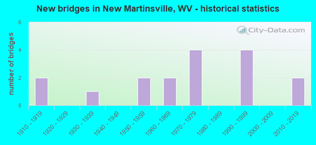
- New bridges - historical statistics
- 21910-1919
- 11930-1939
- 21950-1959
- 21960-1969
- 41970-1979
- 41990-1999
- 22010-2019
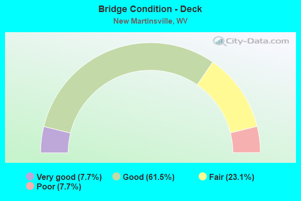
- Bridge Condition - Deck
- 7.7%Very good
- 61.5%Good
- 23.1%Fair
- 7.7%Poor
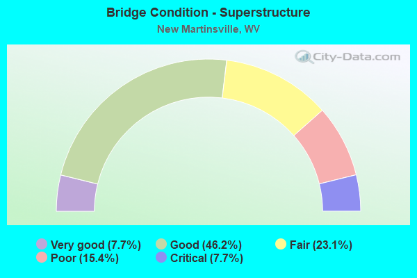
- Bridge Condition - Superstructure
- 7.7%Very good
- 46.2%Good
- 23.1%Fair
- 15.4%Poor
- 7.7%Critical
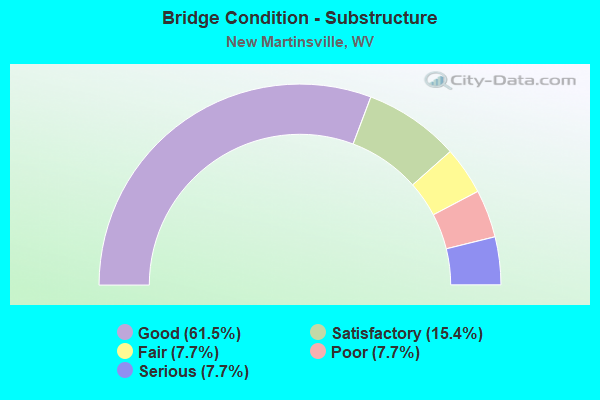
- Bridge Condition - Substructure
- 61.5%Good
- 15.4%Satisfactory
- 7.7%Fair
- 7.7%Poor
- 7.7%Serious
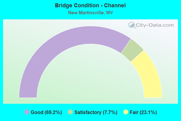
- Bridge Condition - Channel
- 69.2%Good
- 7.7%Satisfactory
- 23.1%Fair
Find on map >> Show street view
Structure Number: 52A003, Location: 0.10 mi. South jct WV 7 (Lat: 39.635781, Lng: -80.858469), Route carried "on" structure: State highway 2, Year Built: 1991, Status: Open, Structure Length: 8.41m (27.59ft), Average Daily Traffic: 12,300 (year 2018), Truck Traffic: 8%, Average Future Daily Traffic: 15,006 (year 2038), Design Load: HS 25 or greater, Features Intersected: Fishing Creek
Minimum Vertical Clearance: 30+ m (98+ ft), Kilometerpoint: 8.352, Lanes on structure: 2, Base Highway Network: Yes, Owner: State Highway Agency, Approaching Roadway Width: 14.6m (47.9ft), Skew: 1 degrees, Material/Design: Prestressed concrete, Design/Construction: Stringer/Multi-beam, Number Of Spans In Main Unit: 3, Length of Maximum Span: 27.1m (88.9ft), Curb or Sidewalk Widths: Left: 1.5m (4.9ft), Right: 0.2m (0.7ft), Curb-To-Curb Width: 13.3m (43.6ft), Out-to-Out Width: 15.9m (52.2ft)
Condition: Deck: Good, Superstructure: Good, Substructure: Good, Channel: Good, Operating Rating: 88.9 metric tons, Method Used To Determine Operating Rating: Load Factor (LF), Inventory Rating: 60.8 metric tons, Method Used To Determine Inventory Rating: Load Factor (LF), Structural Evaluation: Better than present minimum criteria, Deck Geometry: Somewhat better than minimum adequacy, Waterway Adequacy: Equal to present desirable criteria, Approach Roadway Alignment: Equal to present desirable criteria, Length Of Structure Improvement: 8.41m (27.59ft), Designated Inspection Frequency: Every 24 months, Underwater Inspection Frequency: Every 60 months, Inspection Date: November 2021, Underwater Inspection Date: August 2020, Bridge Improvement Cost: $364,000, Total Project Cost: $364,000 ( Estimate for 2021), Deck Structure Type: Concrete Cast-file-Place, Wearing Surface/Protective System: Wearing Surface: Monolithic Concrete, Deck Protection: Epoxy Coated Reinforcing
Find on map >> Show street view
Structure Number: 52A007, Location: 0.56 MI WEST JCT WV 2 (Lat: 39.659189, Lng: -80.863889), Route carried "on" structure: State highway 700, Year Built: 1959, Year Reconstructed: 1998, Status: Open, Structure Length: 64.01m (210.01ft), Average Daily Traffic: 8,576 (year 2018), Truck Traffic: 8%, Average Future Daily Traffic: 18,095 (year 2038), Design Load: HS 20, Features Intersected: CSX RR, OHIO RIVER, Facility Carried by Structure: WEST VIRGINIA 7
Minimum Vertical Clearance: 5.21m (17.09ft), Kilometerpoint: 0.016, Lanes on structure: 2, Lanes under structure: 1, Base Highway Network: Yes, Owner: State Highway Agency, Approaching Roadway Width: 7.9m (25.9ft), Navigation Control: Yes ( Vertical Clearance: 22.9m (75.1ft), Horizontal Clearance: 121.9m (399.9ft)), Material/Design: Steel, Design/Construction: Truss - Thru, Number Of Spans In Main Unit: 3, Number Of Approach Spans: 5, Length of Maximum Span: 217.9m (714.9ft), Curb or Sidewalk Widths: Left: 0.9m (3.0ft), Right: 0.9m (3.0ft), Curb-To-Curb Width: 8.5m (27.9ft), Out-to-Out Width: 10.5m (34.4ft)
Condition: Deck: Fair, Superstructure: Fair, Substructure: Satisfactory, Channel: Good, Operating Rating: 51.7 metric tons, Method Used To Determine Operating Rating: Load Factor (LF), Inventory Rating: 30.8 metric tons, Method Used To Determine Inventory Rating: Load Factor (LF), Structural Evaluation: Somewhat better than minimum adequacy, Deck Geometry: Meets minimum limits, Underclear: Superior to present desirable criteria, Waterway Adequacy: Equal to present minimum criteria, Approach Roadway Alignment: Equal to present minimum criteria, Designated Inspection Frequency: Every 24 months, Critical Feature Inspection Frequency: Every 12 months, Underwater Inspection Frequency: Every 60 months, Other Special Inspection Frequency: Every 12 months, Inspection Date: August 2020, Critical Feature Inspection Date: August 2021, Underwater Inspection Date: August 2017, Other Special Inspection Date: August 2021, Deck Structure Type: Concrete Cast-file-Place, Wearing Surface/Protective System: Wearing Surface: Monolithic Concrete, Deck Protection: Epoxy Coated Reinforcing
Find on map >> Show street view
Structure Number: 52A008, Location: 0.07 mi. West jct WV 2 (Lat: 39.658911, Lng: -80.857750), Route carried "on" structure: Spur State highway 7, Year Built: 1960, Status: Posted for load, Structure Length: 5.14m (16.86ft), Average Daily Traffic: 9,702 (year 2017), Truck Traffic: 8%, Average Future Daily Traffic: 11,836 (year 2037), Design Load: HS 20, Features Intersected: WV 2 NB & SB
Minimum Vertical Clearance: 30+ m (98+ ft), Kilometerpoint: 0.113, Lanes on structure: 2, Lanes under structure: 5, Base Highway Network: Yes, Owner: State Highway Agency, Approaching Roadway Width: 12.8m (42.0ft), Skew: 21 degrees, Material/Design: Steel continuous, Design/Construction: Stringer/Multi-beam, Number Of Spans In Main Unit: 2, Length of Maximum Span: 26.8m (87.9ft), Curb or Sidewalk Widths: Left: 0.9m (3.0ft), Right: 0.9m (3.0ft), Curb-To-Curb Width: 12.3m (40.4ft), Out-to-Out Width: 14.6m (47.9ft)
Condition: Deck: Poor, Superstructure: Poor, Substructure: Poor, Operating Rating: 60.8 metric tons, Method Used To Determine Operating Rating: Load Factor (LF), Inventory Rating: 36.3 metric tons, Method Used To Determine Inventory Rating: Load Factor (LF), Structural Evaluation: Meets minimum limits, Deck Geometry: Somewhat better than minimum adequacy, Underclear: Meets minimum limits, Approach Roadway Alignment: Meets minimum limits, Length Of Structure Improvement: 5.18m (16.99ft), Designated Inspection Frequency: Every 24 months, Other Special Inspection Frequency: Every 12 months, Inspection Date: December 2020, Other Special Inspection Date: December 2021, Bridge Improvement Cost: $571,000, Roadway Improvement Cost: $20,000, Total Project Cost: $716,000 ( Estimate for 2018), Deck Structure Type: Concrete Cast-file-Place, Wearing Surface/Protective System: Wearing Surface: Bituminous
Find on map >> Show street view
Structure Number: 52A009, Location: 0.06 mi. West jct CR 32 (Lat: 39.618319, Lng: -80.846981), Route carried "on" structure: State highway 7, Year Built: 1973, Status: Open, Structure Length: 9.27m (30.41ft), Average Daily Traffic: 6,000 (year 2019), Truck Traffic: 8%, Average Future Daily Traffic: 8,400 (year 2039), Design Load: HS 20, Features Intersected: Fishing Creek
Minimum Vertical Clearance: 30+ m (98+ ft), Kilometerpoint: 6.164, Lanes on structure: 2, Base Highway Network: Yes, Owner: State Highway Agency, Approaching Roadway Width: 14.6m (47.9ft), Skew: 2 degrees, Material/Design: Steel continuous, Design/Construction: Stringer/Multi-beam, Number Of Spans In Main Unit: 1, Number Of Approach Spans: 2, Length of Maximum Span: 35.4m (116.1ft), Curb-To-Curb Width: 14.2m (46.6ft), Out-to-Out Width: 15.4m (50.5ft)
Condition: Deck: Fair, Superstructure: Poor, Substructure: Satisfactory, Channel: Good, Operating Rating: 72.6 metric tons, Method Used To Determine Operating Rating: Load Factor (LF), Inventory Rating: 43.5 metric tons, Method Used To Determine Inventory Rating: Load Factor (LF), Structural Evaluation: Meets minimum limits, Deck Geometry: Superior to present desirable criteria, Waterway Adequacy: Equal to present minimum criteria, Approach Roadway Alignment: Equal to present desirable criteria, Length Of Structure Improvement: 9.27m (30.41ft), Designated Inspection Frequency: Every 24 months, Underwater Inspection Frequency: Every 60 months, Inspection Date: March 2021, Underwater Inspection Date: June 2017, Bridge Improvement Cost: $506,000, Total Project Cost: $506,000 ( Estimate for 2021), Deck Structure Type: Concrete Cast-file-Place, Wearing Surface/Protective System: Wearing Surface: Latex Concrete
Find on map >> Show street view
Structure Number: 52A01, Location: 0.11 mi. East jct. CR 32 (Lat: 39.616581, Lng: -80.845111), Route carried "on" structure: State highway 7, Year Built: 1972, Status: Open, Structure Length: 8.46m (27.76ft), Average Daily Traffic: 6,000 (year 2019), Truck Traffic: 8%, Average Future Daily Traffic: 7,320 (year 2039), Design Load: HS 20, Features Intersected: Fishing Creek
Minimum Vertical Clearance: 30+ m (98+ ft), Kilometerpoint: 6.437, Lanes on structure: 2, Base Highway Network: Yes, Owner: State Highway Agency, Approaching Roadway Width: 14.6m (47.9ft), Skew: 2 degrees, Material/Design: Steel continuous, Design/Construction: Stringer/Multi-beam, Number Of Spans In Main Unit: 1, Number Of Approach Spans: 2, Length of Maximum Span: 32.3m (106.0ft), Curb or Sidewalk Widths: Left: 0.2m (0.7ft), Right: 0.2m (0.7ft), Curb-To-Curb Width: 14.2m (46.6ft), Out-to-Out Width: 15.4m (50.5ft)
Condition: Deck: Fair, Superstructure: Fair, Substructure: Good, Channel: Good, Operating Rating: 72.6 metric tons, Method Used To Determine Operating Rating: Load Factor (LF), Inventory Rating: 43.5 metric tons, Method Used To Determine Inventory Rating: Load Factor (LF), Structural Evaluation: Somewhat better than minimum adequacy, Deck Geometry: Superior to present desirable criteria, Waterway Adequacy: Superior to present desirable criteria, Approach Roadway Alignment: Equal to present desirable criteria, Length Of Structure Improvement: 8.44m (27.69ft), Designated Inspection Frequency: Every 24 months, Inspection Date: March 2021, Bridge Improvement Cost: $586,000, Roadway Improvement Cost: $50,000, Total Project Cost: $636,000 ( Estimate for 2019), Deck Structure Type: Concrete Cast-file-Place, Wearing Surface/Protective System: Wearing Surface: Latex Concrete
Find on map >> Show street view
Structure Number: 52A028, Location: 0.06 mi. West jct WV7 (Lat: 39.611969, Lng: -80.811239), Route carried "on" structure: County highway 723, Year Built: 1912, Status: Closed, Structure Length: 3.40m (11.15ft), Average Daily Traffic: 50 (year 2011), Average Future Daily Traffic: 61 (year 2031), Features Intersected: Little Fishing Creek, Facility Carried by Structure: County Route 7/23
Minimum Vertical Clearance: 30+ m (98+ ft), Kilometerpoint: 1.979, Lanes on structure: 1, Owner: State Highway Agency, Approaching Roadway Width: 6.7m (22.0ft), Material/Design: Steel, Design/Construction: Truss - Thru, Number Of Spans In Main Unit: 1, Length of Maximum Span: 32.9m (107.9ft), Curb-To-Curb Width: 3.7m (12.1ft), Out-to-Out Width: 3.9m (12.8ft)
Condition: Deck: Good, Superstructure: Critical, Substructure: Serious, Channel: Satisfactory, Deck Geometry: Meets minimum limits, Waterway Adequacy: Better than present minimum criteria, Approach Roadway Alignment: Somewhat better than minimum adequacy, Length Of Structure Improvement: 3.96m (12.99ft), Designated Inspection Frequency: Every 24 months, Inspection Date: January 2021, Bridge Improvement Cost: $393,000, Roadway Improvement Cost: $385,000, Total Project Cost: $920,000, Deck Structure Type: Open Grating, Wearing Surface/Protective System: Wearing Surface: Other
Find on map >> Show street view
Structure Number: 52A07, Location: 0.18 mi. South jct WV7 (Lat: 39.614131, Lng: -80.830700), Route carried "on" structure: State highway 20, Year Built: 1977, Status: Open, Structure Length: 4.14m (13.58ft), Average Daily Traffic: 2,100 (year 2020), Truck Traffic: 9%, Average Future Daily Traffic: 2,835 (year 2040), Design Load: HS 20, Features Intersected: Little Fishing Creek
Minimum Vertical Clearance: 30+ m (98+ ft), Kilometerpoint: 47.862, Lanes on structure: 2, Base Highway Network: Yes, Owner: State Highway Agency, Approaching Roadway Width: 8.5m (27.9ft), Skew: 3 degrees, Material/Design: Steel continuous, Design/Construction: Stringer/Multi-beam, Number Of Spans In Main Unit: 2, Length of Maximum Span: 19.8m (65.0ft), Curb or Sidewalk Widths: Left: 0.3m (1.0ft), Right: 0.3m (1.0ft), Curb-To-Curb Width: 8.7m (28.5ft), Out-to-Out Width: 9.9m (32.5ft)
Condition: Deck: Good, Superstructure: Good, Substructure: Good, Channel: Good, Operating Rating: 69.8 metric tons, Method Used To Determine Operating Rating: Load Factor (LF), Inventory Rating: 41.7 metric tons, Method Used To Determine Inventory Rating: Load Factor (LF), Structural Evaluation: Better than present minimum criteria, Deck Geometry: Meets minimum limits, Waterway Adequacy: Meets minimum limits, Approach Roadway Alignment: Somewhat better than minimum adequacy, Length Of Structure Improvement: 4.05m (13.29ft), Designated Inspection Frequency: Every 24 months, Inspection Date: August 2021, Bridge Improvement Cost: $114,000, Roadway Improvement Cost: $10,000, Total Project Cost: $153,000 ( Estimate for 2021), Deck Structure Type: Concrete Cast-file-Place, Wearing Surface/Protective System: Wearing Surface: Monolithic Concrete, Deck Protection: Epoxy Coated Reinforcing
Find on map >> Show street view
Structure Number: 52A115, Location: 0.15 mi. North jct WV 7 (Lat: 39.638461, Lng: -80.857469), Route carried "on" structure: State highway 2, Year Built: 1936, Status: Open, Structure Length: 0.91m (2.99ft), Average Daily Traffic: 12,300 (year 2019), Truck Traffic: 8%, Average Future Daily Traffic: 1,650 (year 2039), Features Intersected: Doolin Run
Minimum Vertical Clearance: 30+ m (98+ ft), Kilometerpoint: 8.755, Lanes on structure: 2, Base Highway Network: Yes, Owner: State Highway Agency, Approaching Roadway Width: 9.1m (29.9ft), Skew: 2 degrees, Material/Design: Concrete continuous, Design/Construction: Culvert, Number Of Spans In Main Unit: 2, Length of Maximum Span: 3.9m (12.8ft)
Condition: Channel: Fair, Culverts: Fair, Operating Rating: 63.5 metric tons, Method Used To Determine Operating Rating: Field evaluation and documented engineering judgment, Inventory Rating: 29.0 metric tons, Method Used To Determine Inventory Rating: Field evaluation and documented engineering judgment, Structural Evaluation: Somewhat better than minimum adequacy, Waterway Adequacy: Equal to present minimum criteria, Approach Roadway Alignment: Equal to present minimum criteria, Length Of Structure Improvement: 0.91m (2.99ft), Designated Inspection Frequency: Every 24 months, Inspection Date: March 2021, Bridge Improvement Cost: $91,000, Roadway Improvement Cost: $191,000, Total Project Cost: $382,000 ( Estimate for 2019)
Find on map >> Show street view
Structure Number: 52A119, Location: 0.84 mi South of WV 7 (Lat: 39.612100, Lng: -80.816569), Route carried "on" structure: County highway 723, Year Built: 1995, Status: Open, Structure Length: 2.87m (9.42ft), Average Daily Traffic: 50 (year 2018), Truck Traffic: 8%, Average Future Daily Traffic: 61 (year 2038), Design Load: HS 25 or greater, Features Intersected: Little Fishing Creek, Facility Carried by Structure: County Route 7/23
Minimum Vertical Clearance: 30+ m (98+ ft), Kilometerpoint: 1.352, Lanes on structure: 1, Owner: State Highway Agency, Approaching Roadway Width: 7.0m (23.0ft), Material/Design: Prestressed concrete, Design/Construction: Box Beam or Girders - Multiple, Number Of Spans In Main Unit: 1, Length of Maximum Span: 27.4m (89.9ft), Curb-To-Curb Width: 4.6m (15.1ft), Out-to-Out Width: 4.6m (15.1ft)
Condition: Deck: Good, Superstructure: Good, Substructure: Good, Channel: Good, Operating Rating: 88.9 metric tons, Method Used To Determine Operating Rating: Load Factor (LF), Inventory Rating: 64.4 metric tons, Method Used To Determine Inventory Rating: Load Factor (LF), Structural Evaluation: Better than present minimum criteria, Deck Geometry: Better than present minimum criteria, Waterway Adequacy: Superior to present desirable criteria, Approach Roadway Alignment: Equal to present minimum criteria, Length Of Structure Improvement: 2.90m (9.51ft), Designated Inspection Frequency: Every 48 months, Inspection Date: October 2019, Bridge Improvement Cost: $193,000, Roadway Improvement Cost: $188,000, Total Project Cost: $381,000 ( Estimate for 2019), Deck Structure Type: Other, Wearing Surface/Protective System: Wearing Surface: Bituminous, Deck Protection: Epoxy Coated Reinforcing
Find on map >> Show street view
Structure Number: 52A122, Location: 0.01 mi. East jct CR1/3 (Lat: 39.698581, Lng: -80.812819), Route carried "on" structure: County highway 89, Year Built: 1998, Status: Open, Structure Length: 2.22m (7.28ft), Average Daily Traffic: 1,000 (year 2020), Truck Traffic: 8%, Average Future Daily Traffic: 1,370 (year 2040), Design Load: HS 25 or greater, Features Intersected: Left Fork Proctor Creek
Minimum Vertical Clearance: 30+ m (98+ ft), Kilometerpoint: 1.609, Lanes on structure: 2, Owner: State Highway Agency, Approaching Roadway Width: 11.0m (36.1ft), Skew: 1 degrees, Material/Design: Prestressed concrete, Design/Construction: Box Beam or Girders - Multiple, Number Of Spans In Main Unit: 1, Length of Maximum Span: 21.5m (70.5ft), Curb-To-Curb Width: 10.9m (35.8ft), Out-to-Out Width: 11.3m (37.1ft)
Condition: Deck: Good, Superstructure: Good, Substructure: Good, Channel: Fair, Operating Rating: 67.1 metric tons, Method Used To Determine Operating Rating: Load Factor (LF), Inventory Rating: 39.9 metric tons, Method Used To Determine Inventory Rating: Load Factor (LF), Structural Evaluation: Better than present minimum criteria, Deck Geometry: Equal to present minimum criteria, Waterway Adequacy: Equal to present minimum criteria, Approach Roadway Alignment: Somewhat better than minimum adequacy, Length Of Structure Improvement: 1.65m (5.41ft), Designated Inspection Frequency: Every 24 months, Inspection Date: December 2021, Bridge Improvement Cost: $50,000, Roadway Improvement Cost: $10,000, Total Project Cost: $114,000 ( Estimate for 2019), Deck Structure Type: Other, Wearing Surface/Protective System: Wearing Surface: Bituminous
Find on map >> Show street view
Structure Number: 52A124, Location: 0.05 mi. West jct CR 7/9 (Lat: 39.640111, Lng: -80.856011), Route carried "on" structure: County highway 71, Year Built: 1999, Status: Open, Structure Length: 1.62m (5.31ft), Average Daily Traffic: 700 (year 2012), Truck Traffic: 8%, Average Future Daily Traffic: 854 (year 2032), Design Load: HS 25 or greater, Features Intersected: Doolin Run, Facility Carried by Structure: County Route 7/1
Minimum Vertical Clearance: 30+ m (98+ ft), Kilometerpoint: 0.016, Lanes on structure: 2, Owner: State Highway Agency, Approaching Roadway Width: 7.9m (25.9ft), Skew: 1 degrees, Material/Design: Prestressed concrete, Design/Construction: Box Beam or Girders - Multiple, Number Of Spans In Main Unit: 1, Length of Maximum Span: 15.0m (49.2ft), Curb-To-Curb Width: 9.0m (29.5ft), Out-to-Out Width: 9.3m (30.5ft)
Condition: Deck: Good, Superstructure: Good, Substructure: Good, Channel: Good, Operating Rating: 79.8 metric tons, Method Used To Determine Operating Rating: Load Factor (LF), Inventory Rating: 48.1 metric tons, Method Used To Determine Inventory Rating: Load Factor (LF), Structural Evaluation: Better than present minimum criteria, Deck Geometry: Somewhat better than minimum adequacy, Waterway Adequacy: Equal to present desirable criteria, Approach Roadway Alignment: Equal to present minimum criteria, Length Of Structure Improvement: 1.68m (5.51ft), Designated Inspection Frequency: Every 48 months, Inspection Date: June 2019, Bridge Improvement Cost: $150,000, Roadway Improvement Cost: $150,000, Total Project Cost: $300,000 ( Estimate for 2015), Deck Structure Type: Other, Wearing Surface/Protective System: Wearing Surface: Bituminous, Deck Protection: Epoxy Coated Reinforcing
Find on map >> Show street view
Structure Number: 52A158, Location: 0.02 mi. South jct WV 20 (Lat: 39.590511, Lng: -80.809100), Route carried "on" structure: County highway 36, Year Built: 2012, Status: Open, Structure Length: 6.16m (20.21ft), Average Daily Traffic: 100 (year 2019), Truck Traffic: 8%, Average Future Daily Traffic: 122 (year 2039), Design Load: HL 93, Features Intersected: Fishing Creek
Minimum Vertical Clearance: 30+ m (98+ ft), Kilometerpoint: 3.476, Lanes on structure: 2, Owner: State Highway Agency, Approaching Roadway Width: 6.7m (22.0ft), Skew: 1 degrees, Material/Design: Steel continuous, Design/Construction: Stringer/Multi-beam, Number Of Spans In Main Unit: 1, Number Of Approach Spans: 2, Length of Maximum Span: 23.2m (76.1ft), Curb-To-Curb Width: 6.7m (22.0ft), Out-to-Out Width: 7.5m (24.6ft)
Condition: Deck: Good, Superstructure: Good, Substructure: Good, Channel: Good, Operating Rating: 88.9 metric tons, Method Used To Determine Operating Rating: Load and Resistance Factor (LRFR), Inventory Rating: 88.9 metric tons, Method Used To Determine Inventory Rating: Load and Resistance Factor (LRFR), Structural Evaluation: Better than present minimum criteria, Deck Geometry: Somewhat better than minimum adequacy, Waterway Adequacy: Equal to present desirable criteria, Approach Roadway Alignment: Equal to present minimum criteria, Designated Inspection Frequency: Every 24 months, Underwater Inspection Frequency: Every 60 months, Inspection Date: July 2020, Underwater Inspection Date: August 2021, Deck Structure Type: Concrete Cast-file-Place, Wearing Surface/Protective System: Wearing Surface: Latex Concrete, Deck Protection: Epoxy Coated Reinforcing
Find on map >> Show street view
Structure Number: 52A164, Location: .06 mi. South jct CR89 (Lat: 39.709011, Lng: -80.822961), Route carried "on" structure: State highway 2, Year Built: 2019, Status: Open, Structure Length: 5.54m (18.18ft), Average Daily Traffic: 7,300 (year 2018), Truck Traffic: 8%, Average Future Daily Traffic: 8,906 (year 2038), Design Load: HL 93, Features Intersected: Proctor Creek
Minimum Vertical Clearance: 30+ m (98+ ft), Kilometerpoint: 18.186, Lanes on structure: 4, Base Highway Network: Yes, Owner: State Highway Agency, Approaching Roadway Width: 24.4m (80.1ft), Skew: 10 degrees, Material/Design: Steel, Design/Construction: Stringer/Multi-beam, Number Of Spans In Main Unit: 1, Length of Maximum Span: 55.4m (181.8ft), Curb-To-Curb Width: 23.8m (78.1ft), Out-to-Out Width: 24.5m (80.4ft)
Condition: Deck: Very good, Superstructure: Very good, Substructure: Good, Channel: Good, Operating Rating: 40.8 metric tons, Method Used To Determine Operating Rating: Load and Resistance Factor (LRFR), Inventory Rating: 32.7 metric tons, Method Used To Determine Inventory Rating: Load and Resistance Factor (LRFR), Structural Evaluation: Better than present minimum criteria, Deck Geometry: Superior to present desirable criteria, Waterway Adequacy: Somewhat better than minimum adequacy, Approach Roadway Alignment: Equal to present minimum criteria, Designated Inspection Frequency: Every 24 months, Inspection Date: December 2021, Deck Structure Type: Concrete Cast-file-Place, Wearing Surface/Protective System: Wearing Surface: Monolithic Concrete, Deck Protection: Epoxy Coated Reinforcing
Find on map >> Show street view
Structure Number: 52A998, Location: 0.50 mi. West jct WV 2 (Lat: 39.637781, Lng: -80.866269), Route carried "on" structure: Other road N0099, Year Built: 1974, Status: Posted for load, Structure Length: 8.50m (27.89ft), Average Daily Traffic: 1,500 (year 2019), Truck Traffic: 8%, Average Future Daily Traffic: 2,655 (year 2039), Design Load: HS 15, Features Intersected: Fishing Creek, Facility Carried by Structure: Main Street
Minimum Vertical Clearance: 30+ m (98+ ft), Kilometerpoint: 0.080, Lanes on structure: 2, Owner: Local Agency, Approaching Roadway Width: 11.6m (38.1ft), Material/Design: Steel, Design/Construction: Stringer/Multi-beam, Number Of Spans In Main Unit: 1, Number Of Approach Spans: 2, Length of Maximum Span: 45.4m (149.0ft), Curb or Sidewalk Widths: Left: 0.2m (0.7ft), Right: 1.1m (3.6ft), Curb-To-Curb Width: 6.7m (22.0ft), Out-to-Out Width: 8.5m (27.9ft)
Condition: Deck: Good, Superstructure: Fair, Substructure: Fair, Channel: Fair, Operating Rating: 52.6 metric tons, Method Used To Determine Operating Rating: Load Factor (LF), Inventory Rating: 31.7 metric tons, Method Used To Determine Inventory Rating: Load Factor (LF), Structural Evaluation: Somewhat better than minimum adequacy, Deck Geometry: High priority of corrective action, Waterway Adequacy: Equal to present desirable criteria, Approach Roadway Alignment: Somewhat better than minimum adequacy, Length Of Structure Improvement: 8.47m (27.79ft), Designated Inspection Frequency: Every 24 months, Underwater Inspection Frequency: Every 12 months, Inspection Date: October 2020, Underwater Inspection Date: August 2021, Bridge Improvement Cost: $183,000, Roadway Improvement Cost: $5,000, Total Project Cost: $188,000 ( Estimate for 2016), Deck Structure Type: Concrete Cast-file-Place, Wearing Surface/Protective System: Wearing Surface: Monolithic Concrete
Find on map >> Show street view
Structure Number: 52A007, Location: 0.56 MI WEST JCT WV 2 (Lat: 39.000000, Lng: -80.000000), Route carried "under" structure: Business City street , Year Built: 1959, Structure Length: 0. m, Features Intersected: CSX RR, OHIO RIVER, Facility Carried by Structure: WEST VIRGINIA 7
Minimum Vertical Clearance: 7.93m (26.02ft), Kilometerpoint: 0.000, Lanes on structure: 2, Lanes under structure: 2, Length of Maximum Span: 217.9m (714.9ft)
Find on map >> Show street view
Structure Number: 52A008, Location: 0.07 mi. West jct WV 2 (Lat: 39.658911, Lng: -80.857750), Route carried "under" structure: State highway 2, Year Built: 1960, Structure Length: 0. m, Average Daily Traffic: 18,285 (year 0014), Truck Traffic: 8%, Features Intersected: WV 2 NB & SB, Facility Carried by Structure: West Virginia 7 SP
Minimum Vertical Clearance: 4.62m (15.16ft), Kilometerpoint: 11.008, Lanes on structure: 2, Lanes under structure: 5, Length of Maximum Span: 26.8m (87.9ft)
Find on map >> Show street view
Structure Number: 52A9, Location: 0.20 Mi West Jct. WV Rt 2 (Lat: 39.637061, Lng: -80.863061), Route carried "under" structure: City street N1150, Year Built: 1913, Structure Length: 0. m, Features Intersected: Harlon Dr.(City St.), Facility Carried by Structure: CSX Railroad
Minimum Vertical Clearance: 4.17m (13.68ft), Kilometerpoint: 0.016, Lanes under structure: 2, Length of Maximum Span: 13.3m (43.6ft)