Bridge Statistics for New Market, Tennessee (TN)
Condition, Traffic, Stress, Structural Evaluation, Project Costs
- National Bridge Inventory (NBI) Statistics
- 16Number of bridges
- 56ft / 16.6mTotal length
- $2,967,000Total costs
- 45,405Total average daily traffic
- 2,921Total average daily truck traffic
- National Bridge Inventory (NBI) Registered Bridges for New Market
- No street view available for this location
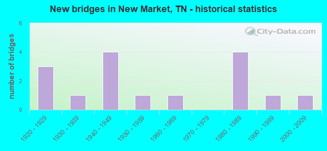
- New bridges - historical statistics
- 31920-1929
- 11930-1939
- 41940-1949
- 11950-1959
- 11960-1969
- 41980-1989
- 11990-1999
- 12000-2009


- Bridge Condition - Deck
- 25.0%Good
- 37.5%Satisfactory
- 12.5%Fair
- 25.0%Poor

- Bridge Condition - Superstructure
- 12.5%Very good
- 12.5%Good
- 25.0%Satisfactory
- 12.5%Fair
- 37.5%Poor

- Bridge Condition - Substructure
- 12.5%Very good
- 12.5%Good
- 12.5%Satisfactory
- 37.5%Fair
- 25.0%Poor

- Bridge Condition - Channel
- 7.1%Very good
- 7.1%Good
- 42.9%Satisfactory
- 35.7%Fair
- 7.1%Poor

- Bridge Condition - Culverts
- 16.7%Good
- 66.7%Satisfactory
- 16.7%Fair
Find on map >> Show street view
Structure Number: 290A3800001, Location: EAST OF US11 (Lat: 36.193781, Lng: -83.562550), Route carried "on" structure: County highway 380, Year Built: 1984, Status: Open, Structure Length: 1.52m (4.99ft), Average Daily Traffic: 90 (year 2022), Truck Traffic: 4%, Average Future Daily Traffic: 144 (year 2042), Design Load: HS 20+Mod, Features Intersected: BUFFALO CREEK
Minimum Vertical Clearance: 30+ m (98+ ft), Kilometerpoint: 1.992, Lanes on structure: 2, Owner: County Highway Agency, Approaching Roadway Width: 4.6m (15.1ft), Skew: 1 degrees, Material/Design: Concrete continuous, Design/Construction: Box Beam or Girders - Multiple, Number Of Spans In Main Unit: 2, Length of Maximum Span: 7.2m (23.6ft), Curb-To-Curb Width: 7.0m (23.0ft), Out-to-Out Width: 9.0m (29.5ft)
Condition: Deck: Good, Superstructure: Good, Substructure: Good, Channel: Fair, Operating Rating: 44.1 metric tons, Method Used To Determine Operating Rating: Field evaluation and documented engineering judgment, Inventory Rating: 32.4 metric tons, Method Used To Determine Inventory Rating: Field evaluation and documented engineering judgment, Structural Evaluation: Better than present minimum criteria, Deck Geometry: Somewhat better than minimum adequacy, Waterway Adequacy: Equal to present minimum criteria, Approach Roadway Alignment: Equal to present minimum criteria, Designated Inspection Frequency: Every 24 months, Inspection Date: April 2021, Deck Structure Type: Concrete Precast Panels, Wearing Surface/Protective System: Wearing Surface: Bituminous
Find on map >> Show street view
Structure Number: 45024530003, Location: N OFF US11E-W OF NEW MARK (Lat: 36.093850, Lng: -83.605717), Route carried "on" structure: County highway 2453, Year Built: 1986, Status: Open, Structure Length: 1.18m (3.87ft), Average Daily Traffic: 317 (year 2020), Truck Traffic: 3%, Average Future Daily Traffic: 624 (year 2041), Design Load: HS 20, Features Intersected: LOST CREEK
Minimum Vertical Clearance: 30+ m (98+ ft), Kilometerpoint: 9.270, Lanes on structure: 2, Owner: County Highway Agency, Approaching Roadway Width: 5.5m (18.0ft), Skew: 1 degrees, Material/Design: Concrete continuous, Design/Construction: Culvert, Number Of Spans In Main Unit: 3, Length of Maximum Span: 3.7m (12.1ft), Curb-To-Curb Width: 7.5m (24.6ft), Out-to-Out Width: 8.5m (27.9ft)
Condition: Channel: Fair, Culverts: Fair, Operating Rating: 87.3 metric tons, Method Used To Determine Operating Rating: Load Factor (LF), Inventory Rating: 32.4 metric tons, Method Used To Determine Inventory Rating: Load Factor (LF), Structural Evaluation: Somewhat better than minimum adequacy, Deck Geometry: Somewhat better than minimum adequacy, Waterway Adequacy: Equal to present minimum criteria, Approach Roadway Alignment: Equal to present minimum criteria, Length Of Structure Improvement: 1.18m (3.87ft), Designated Inspection Frequency: Every 24 months, Inspection Date: May 2021, Bridge Improvement Cost: $44,000, Roadway Improvement Cost: $5,000, Total Project Cost: $67,000 ( Estimate for 2021), Deck Structure Type: Concrete Cast-file-Place, Wearing Surface/Protective System: Wearing Surface: Bituminous
Find on map >> Show street view
Structure Number: 45024530005, Location: N OF US11E-E OF STRAWBERY (Lat: 36.115217, Lng: -83.601883), Route carried "on" structure: County highway 2453, Year Built: 1934, Status: Posted for load, Structure Length: 0.93m (3.05ft), Average Daily Traffic: 317 (year 2020), Truck Traffic: 3%, Average Future Daily Traffic: 507 (year 2041), Features Intersected: LEWIS CREEK
Minimum Vertical Clearance: 30+ m (98+ ft), Kilometerpoint: 12.134, Lanes on structure: 2, Owner: County Highway Agency, Approaching Roadway Width: 6.1m (20.0ft), Skew: 2 degrees, Material/Design: Concrete, Design/Construction: Slab, Number Of Spans In Main Unit: 2, Length of Maximum Span: 4.0m (13.1ft), Curb-To-Curb Width: 6.9m (22.6ft), Out-to-Out Width: 6.9m (22.6ft)
Condition: Deck: Poor, Superstructure: Poor, Substructure: Poor, Channel: Poor, Operating Rating: 7.2 metric tons, Method Used To Determine Operating Rating: Field evaluation and documented engineering judgment, Inventory Rating: 4.5 metric tons, Method Used To Determine Inventory Rating: Field evaluation and documented engineering judgment, Structural Evaluation: High priority of replacement, Deck Geometry: High priority of replacement, Waterway Adequacy: Meets minimum limits, Approach Roadway Alignment: Equal to present minimum criteria, Bridge Posting: Required (Relationship of Operating Rating to Maximum Legal Load: 10.0 - 19.9% below), Length Of Structure Improvement: 1.60m (5.25ft), Designated Inspection Frequency: Every 24 months, Inspection Date: April 2021, Bridge Improvement Cost: $264,000, Roadway Improvement Cost: $27,000, Total Project Cost: $397,000 ( Estimate for 2021), Deck Structure Type: Concrete Cast-file-Place, Wearing Surface/Protective System: Wearing Surface: Bituminous
Find on map >> Show street view
Structure Number: 45024530007, Location: W OF SR92-NEAR GRAINGER C (Lat: 36.166400, Lng: -83.525933), Route carried "on" structure: County highway 2453, Year Built: 1995, Status: Open, Structure Length: 1.14m (3.74ft), Average Daily Traffic: 1,026 (year 2020), Truck Traffic: 3%, Average Future Daily Traffic: 1,792 (year 2041), Design Load: HS 20, Features Intersected: MILL SPRING CREEK
Minimum Vertical Clearance: 30+ m (98+ ft), Kilometerpoint: 25.379, Lanes on structure: 2, Owner: County Highway Agency, Approaching Roadway Width: 7.6m (24.9ft), Skew: 3 degrees, Material/Design: Concrete continuous, Design/Construction: Culvert, Number Of Spans In Main Unit: 2, Length of Maximum Span: 5.3m (17.4ft), Curb-To-Curb Width: 9.5m (31.2ft), Out-to-Out Width: 11.4m (37.4ft)
Condition: Channel: Good, Culverts: Satisfactory, Operating Rating: 89.1 metric tons, Method Used To Determine Operating Rating: Load Factor (LF), Inventory Rating: 32.4 metric tons, Method Used To Determine Inventory Rating: Load Factor (LF), Structural Evaluation: Equal to present minimum criteria, Deck Geometry: Somewhat better than minimum adequacy, Waterway Adequacy: Better than present minimum criteria, Approach Roadway Alignment: Equal to present minimum criteria, Designated Inspection Frequency: Every 24 months, Inspection Date: May 2021, Deck Structure Type: Concrete Cast-file-Place, Wearing Surface/Protective System: Wearing Surface: Monolithic Concrete, Deck Protection: Epoxy Coated Reinforcing
Find on map >> Show street view
Structure Number: 45024530009, Location: 2 MI N OF SR34(US11E) (Lat: 36.121767, Lng: -83.582433), Route carried "on" structure: County highway 2453, Year Built: 2002, Status: Open, Structure Length: 1.89m (6.20ft), Average Daily Traffic: 1,026 (year 2020), Truck Traffic: 3%, Average Future Daily Traffic: 1,792 (year 2041), Design Load: HS 20, Features Intersected: BRANCH
Minimum Vertical Clearance: 30+ m (98+ ft), Kilometerpoint: 14.726, Lanes on structure: 2, Owner: County Highway Agency, Approaching Roadway Width: 5.2m (17.1ft), Material/Design: Prestressed concrete, Design/Construction: Box Beam or Girders - Single/Spread, Number Of Spans In Main Unit: 1, Length of Maximum Span: 17.4m (57.1ft), Curb-To-Curb Width: 8.5m (27.9ft), Out-to-Out Width: 9.2m (30.2ft)
Condition: Deck: Good, Superstructure: Very good, Substructure: Very good, Channel: Very good, Operating Rating: 63.0 metric tons, Method Used To Determine Operating Rating: Load Factor (LF), Inventory Rating: 32.4 metric tons, Method Used To Determine Inventory Rating: Load Factor (LF), Structural Evaluation: Equal to present desirable criteria, Deck Geometry: Somewhat better than minimum adequacy, Waterway Adequacy: Equal to present desirable criteria, Approach Roadway Alignment: Equal to present desirable criteria, Designated Inspection Frequency: Every 24 months, Inspection Date: May 2021, Deck Structure Type: Concrete Precast Panels, Wearing Surface/Protective System: Wearing Surface: Monolithic Concrete, Deck Protection: Epoxy Coated Reinforcing
Find on map >> Show street view
Structure Number: 45025100003, Location: S OF US11E AT NEW MARKET (Lat: 36.090933, Lng: -83.541517), Route carried "on" structure: County highway 2510, Year Built: 1940, Status: Posted for load, Structure Length: 0.63m (2.07ft), Average Daily Traffic: 242 (year 2020), Truck Traffic: 3%, Average Future Daily Traffic: 387 (year 2041), Features Intersected: LOST CREEK
Minimum Vertical Clearance: 30+ m (98+ ft), Kilometerpoint: 0.161, Lanes on structure: 2, Owner: County Highway Agency, Approaching Roadway Width: 5.5m (18.0ft), Material/Design: Concrete, Design/Construction: Slab, Number Of Spans In Main Unit: 1, Length of Maximum Span: 5.9m (19.4ft), Curb-To-Curb Width: 6.2m (20.3ft), Out-to-Out Width: 6.6m (21.7ft)
Condition: Deck: Poor, Superstructure: Poor, Substructure: Fair, Channel: Satisfactory, Operating Rating: 36.0 metric tons, Method Used To Determine Operating Rating: Field evaluation and documented engineering judgment, Inventory Rating: 24.3 metric tons, Method Used To Determine Inventory Rating: Field evaluation and documented engineering judgment, Structural Evaluation: Meets minimum limits, Deck Geometry: Meets minimum limits, Waterway Adequacy: Equal to present minimum criteria, Approach Roadway Alignment: Equal to present desirable criteria, Length Of Structure Improvement: 0.63m (2.07ft), Designated Inspection Frequency: Every 24 months, Inspection Date: April 2021, Bridge Improvement Cost: $64,000, Roadway Improvement Cost: $7,000, Total Project Cost: $97,000 ( Estimate for 2021), Deck Structure Type: Concrete Cast-file-Place, Wearing Surface/Protective System: Wearing Surface: Bituminous
Find on map >> Show street view
Structure Number: 450A0800001, Location: 3.5 M E OF STRAWBRY PLNS (Lat: 36.069450, Lng: -83.617967), Route carried "on" structure: County highway 80, Year Built: 1986, Status: Open, Structure Length: 1.15m (3.77ft), Average Daily Traffic: 350 (year 2022), Truck Traffic: 2%, Average Future Daily Traffic: 560 (year 2041), Design Load: HS 20, Features Intersected: BEAVER CREEK
Minimum Vertical Clearance: 30+ m (98+ ft), Kilometerpoint: 0.076, Lanes on structure: 2, Owner: County Highway Agency, Approaching Roadway Width: 6.1m (20.0ft), Material/Design: Concrete continuous, Design/Construction: Culvert, Number Of Spans In Main Unit: 3, Length of Maximum Span: 3.7m (12.1ft), Curb-To-Curb Width: 7.3m (24.0ft), Out-to-Out Width: 8.4m (27.6ft)
Condition: Channel: Satisfactory, Culverts: Satisfactory, Operating Rating: 52.2 metric tons, Method Used To Determine Operating Rating: Load Factor (LF), Inventory Rating: 32.4 metric tons, Method Used To Determine Inventory Rating: Load Factor (LF), Structural Evaluation: Equal to present minimum criteria, Deck Geometry: Somewhat better than minimum adequacy, Waterway Adequacy: Equal to present minimum criteria, Approach Roadway Alignment: Equal to present desirable criteria, Designated Inspection Frequency: Every 24 months, Inspection Date: May 2021, Deck Structure Type: Concrete Cast-file-Place, Wearing Surface/Protective System: Wearing Surface: Bituminous
Find on map >> Show street view
Structure Number: 450A0820001, Location: 3 M NW OF NEW MARKET (Lat: 36.100667, Lng: -83.611583), Route carried "on" structure: County highway 82, Year Built: 1942, Status: Posted for load, Structure Length: 1.12m (3.67ft), Average Daily Traffic: 90 (year 2022), Truck Traffic: 2%, Average Future Daily Traffic: 144 (year 2041), Features Intersected: LOST CREEK
Minimum Vertical Clearance: 30+ m (98+ ft), Kilometerpoint: 3.009, Lanes on structure: 2, Owner: County Highway Agency, Approaching Roadway Width: 4.6m (15.1ft), Skew: 1 degrees, Material/Design: Steel, Design/Construction: Stringer/Multi-beam, Number Of Spans In Main Unit: 1, Length of Maximum Span: 9.6m (31.5ft), Curb-To-Curb Width: 5.3m (17.4ft), Out-to-Out Width: 5.6m (18.4ft)
Condition: Deck: Fair, Superstructure: Poor, Substructure: Poor, Channel: Satisfactory, Operating Rating: 3.9 metric tons, Method Used To Determine Operating Rating: Load and Resistance Factor Rating (LRFR) rating reported by rating factor(RF) method using HL-93 loadings, Inventory Rating: 2.9 metric tons, Method Used To Determine Inventory Rating: Load and Resistance Factor Rating (LRFR) rating reported by rating factor(RF) method using HL-93 loadings, Structural Evaluation: High priority of replacement, Deck Geometry: High priority of corrective action, Waterway Adequacy: Equal to present minimum criteria, Approach Roadway Alignment: Equal to present desirable criteria, Bridge Posting: Required (Relationship of Operating Rating to Maximum Legal Load: 10.0 - 19.9% below), Length Of Structure Improvement: 1.79m (5.87ft), Designated Inspection Frequency: Every 24 months, Inspection Date: April 2021, Bridge Improvement Cost: $324,000, Roadway Improvement Cost: $33,000, Total Project Cost: $487,000 ( Estimate for 2021), Deck Structure Type: Concrete Cast-file-Place, Wearing Surface/Protective System: Wearing Surface: Bituminous
Find on map >> Show street view
Structure Number: 450A1450001, Location: IN NEW MARKET-S OF US11E (Lat: 36.100550, Lng: -83.549933), Route carried "on" structure: County highway 1296, Year Built: 1921, Status: Open, Structure Length: 1.04m (3.41ft), Average Daily Traffic: 1,278 (year 2020), Truck Traffic: 3%, Average Future Daily Traffic: 2,045 (year 2041), Features Intersected: LOST CREEK, Facility Carried by Structure: NFA A145
Minimum Vertical Clearance: 30+ m (98+ ft), Kilometerpoint: 26.450, Lanes on structure: 2, Owner: City or Municipal Highway Agency, Approaching Roadway Width: 5.8m (19.0ft), Skew: 4 degrees, Material/Design: Concrete, Design/Construction: Arch - Deck, Number Of Spans In Main Unit: 1, Length of Maximum Span: 8.5m (27.9ft), Curb-To-Curb Width: 6.0m (19.7ft), Out-to-Out Width: 6.7m (22.0ft)
Condition: Deck: Satisfactory, Superstructure: Satisfactory, Substructure: Fair, Channel: Fair, Operating Rating: 36.0 metric tons, Method Used To Determine Operating Rating: Field evaluation and documented engineering judgment, Inventory Rating: 24.3 metric tons, Method Used To Determine Inventory Rating: Field evaluation and documented engineering judgment, Structural Evaluation: Somewhat better than minimum adequacy, Deck Geometry: High priority of replacement, Waterway Adequacy: Somewhat better than minimum adequacy, Approach Roadway Alignment: Equal to present desirable criteria, Length Of Structure Improvement: 1.04m (3.41ft), Designated Inspection Frequency: Every 24 months, Inspection Date: May 2021, Bridge Improvement Cost: $127,000, Roadway Improvement Cost: $13,000, Total Project Cost: $191,000 ( Estimate for 2021), Deck Structure Type: Concrete Cast-file-Place, Wearing Surface/Protective System: Wearing Surface: Bituminous
Find on map >> Show street view
Structure Number: 450A1550001, Location: N OF US11E-W OF NEW MARKE (Lat: 36.097083, Lng: -83.584867), Route carried "on" structure: County highway 155, Year Built: 1984, Status: Open, Structure Length: 1.40m (4.59ft), Average Daily Traffic: 390 (year 2022), Truck Traffic: 2%, Average Future Daily Traffic: 624 (year 2041), Design Load: HS 20+Mod, Features Intersected: LOST CREEK
Minimum Vertical Clearance: 30+ m (98+ ft), Kilometerpoint: 0.232, Lanes on structure: 2, Owner: County Highway Agency, Approaching Roadway Width: 6.4m (21.0ft), Material/Design: Concrete continuous, Design/Construction: Culvert, Number Of Spans In Main Unit: 3, Length of Maximum Span: 4.6m (15.1ft)
Condition: Channel: Fair, Culverts: Good, Operating Rating: 48.6 metric tons, Method Used To Determine Operating Rating: Load Factor (LF), Inventory Rating: 32.4 metric tons, Method Used To Determine Inventory Rating: Load Factor (LF), Structural Evaluation: Better than present minimum criteria, Waterway Adequacy: Somewhat better than minimum adequacy, Approach Roadway Alignment: Equal to present desirable criteria, Designated Inspection Frequency: Every 24 months, Inspection Date: May 2021
Find on map >> Show street view
Structure Number: 45S24650001, Location: 3 M NW OF US70-I40 JCT (Lat: 36.026050, Lng: -83.529233), Route carried "on" structure: County highway 1296, Year Built: 1955, Status: Posted for load, Structure Length: 0.86m (2.82ft), Average Daily Traffic: 638 (year 2020), Truck Traffic: 3%, Average Future Daily Traffic: 1,021 (year 2041), Design Load: H 15, Features Intersected: PIEDMONT BRANCH
Minimum Vertical Clearance: 30+ m (98+ ft), Kilometerpoint: 16.560, Lanes on structure: 2, Owner: County Highway Agency, Approaching Roadway Width: 6.7m (22.0ft), Skew: 2 degrees, Material/Design: Concrete, Design/Construction: Slab, Number Of Spans In Main Unit: 2, Length of Maximum Span: 4.1m (13.5ft), Curb-To-Curb Width: 7.1m (23.3ft), Out-to-Out Width: 7.5m (24.6ft)
Condition: Deck: Satisfactory, Superstructure: Satisfactory, Substructure: Fair, Channel: Satisfactory, Operating Rating: 36.0 metric tons, Method Used To Determine Operating Rating: Field evaluation and documented engineering judgment, Inventory Rating: 24.3 metric tons, Method Used To Determine Inventory Rating: Field evaluation and documented engineering judgment, Structural Evaluation: Somewhat better than minimum adequacy, Deck Geometry: Meets minimum limits, Waterway Adequacy: Somewhat better than minimum adequacy, Approach Roadway Alignment: Equal to present desirable criteria, Length Of Structure Improvement: 0.86m (2.82ft), Designated Inspection Frequency: Every 24 months, Inspection Date: May 2021, Bridge Improvement Cost: $68,000, Roadway Improvement Cost: $7,000, Total Project Cost: $103,000 ( Estimate for 2021), Deck Structure Type: Concrete Cast-file-Place, Wearing Surface/Protective System: Wearing Surface: Monolithic Concrete
Find on map >> Show street view
Structure Number: 45S24650003, Location: ON US 11E ROW-NEW MARKET (Lat: 36.101417, Lng: -83.552250), Route carried "on" structure: City street 172, Year Built: 1965, Status: Open, Structure Length: 0.87m (2.85ft), Average Daily Traffic: 3,460 (year 2022), Truck Traffic: 9%, Average Future Daily Traffic: 5,536 (year 2041), Design Load: H 15, Features Intersected: LOST CREEK
Minimum Vertical Clearance: 30+ m (98+ ft), Kilometerpoint: 0.169, Lanes on structure: 2, Owner: City or Municipal Highway Agency, Approaching Roadway Width: 6.4m (21.0ft), Material/Design: Concrete, Design/Construction: Channel Beam, Number Of Spans In Main Unit: 1, Length of Maximum Span: 8.0m (26.2ft), Curb-To-Curb Width: 8.8m (28.9ft), Out-to-Out Width: 11.3m (37.1ft)
Condition: Deck: Satisfactory, Superstructure: Fair, Substructure: Satisfactory, Channel: Satisfactory, Operating Rating: 38.7 metric tons, Method Used To Determine Operating Rating: Load Factor (LF), Inventory Rating: 23.4 metric tons, Method Used To Determine Inventory Rating: Load Factor (LF), Structural Evaluation: Somewhat better than minimum adequacy, Deck Geometry: Meets minimum limits, Waterway Adequacy: Equal to present minimum criteria, Approach Roadway Alignment: Equal to present desirable criteria, Length Of Structure Improvement: 0.87m (2.85ft), Designated Inspection Frequency: Every 24 months, Inspection Date: May 2021, Bridge Improvement Cost: $193,000, Roadway Improvement Cost: $20,000, Total Project Cost: $290,000 ( Estimate for 2021), Deck Structure Type: Concrete Precast Panels, Wearing Surface/Protective System: Wearing Surface: Bituminous
Find on map >> Show street view
Structure Number: 45SR0340005, Location: .1 M N OF SOU RR (Lat: 36.097483, Lng: -83.564517), Route carried "on" structure: US 11, Year Built: 1949, Year Reconstructed: 1964, Status: Open, Structure Length: 1.95m (6.40ft), Average Daily Traffic: 16,202 (year 2020), Truck Traffic: 7%, Average Future Daily Traffic: 25,923 (year 2041), Design Load: HS 20, Features Intersected: LOST CREEK, Facility Carried by Structure: FAP 34
Minimum Vertical Clearance: 30+ m (98+ ft), Kilometerpoint: 12.424, Lanes on structure: 4, Base Highway Network: Yes, Owner: State Highway Agency, Approaching Roadway Width: 19.9m (65.3ft), Skew: 24 degrees, Material/Design: Concrete continuous, Design/Construction: Culvert, Number Of Spans In Main Unit: 4, Length of Maximum Span: 4.3m (14.1ft)
Condition: Channel: Fair, Culverts: Satisfactory, Operating Rating: 28.8 metric tons, Method Used To Determine Operating Rating: Load Factor (LF), Inventory Rating: 22.5 metric tons, Method Used To Determine Inventory Rating: Load Factor (LF), Structural Evaluation: Somewhat better than minimum adequacy, Waterway Adequacy: Equal to present minimum criteria, Approach Roadway Alignment: Equal to present desirable criteria, Length Of Structure Improvement: 1.95m (6.40ft), Designated Inspection Frequency: Every 24 months, Inspection Date: October 2021, Bridge Improvement Cost: $591,000, Roadway Improvement Cost: $60,000, Total Project Cost: $887,000 ( Estimate for 2021)
Find on map >> Show street view
Structure Number: 45SR0340007, Location: NEAR JEFFERSON CITY (Lat: 36.101000, Lng: -83.553600), Route carried "on" structure: US 11, Year Built: 1949, Year Reconstructed: 1964, Status: Open, Structure Length: 0.91m (2.99ft), Average Daily Traffic: 16,202 (year 2020), Truck Traffic: 7%, Average Future Daily Traffic: 25,923 (year 2041), Design Load: HS 20, Features Intersected: BRANCH, Facility Carried by Structure: FAP 34
Minimum Vertical Clearance: 30+ m (98+ ft), Kilometerpoint: 13.486, Lanes on structure: 4, Base Highway Network: Yes, Owner: State Highway Agency, Approaching Roadway Width: 20.8m (68.2ft), Skew: 24 degrees, Material/Design: Concrete continuous, Design/Construction: Culvert, Number Of Spans In Main Unit: 2, Length of Maximum Span: 4.3m (14.1ft)
Condition: Channel: Satisfactory, Culverts: Satisfactory, Operating Rating: 68.4 metric tons, Method Used To Determine Operating Rating: Load Factor (LF), Inventory Rating: 32.4 metric tons, Method Used To Determine Inventory Rating: Load Factor (LF), Structural Evaluation: Equal to present minimum criteria, Waterway Adequacy: Equal to present minimum criteria, Approach Roadway Alignment: Equal to present desirable criteria, Length Of Structure Improvement: 0.91m (2.99ft), Designated Inspection Frequency: Every 24 months, Inspection Date: October 2021, Bridge Improvement Cost: $298,000, Roadway Improvement Cost: $30,000, Total Project Cost: $448,000 ( Estimate for 2021)
Find on map >> Show street view
Structure Number: 45024530001, Location: N OF US11E-E OF STRAWBERR (Lat: 36.090700, Lng: -83.605033), Route carried "under" structure: County highway 2453, Year Built: 1925, Structure Length: 0. m, Average Daily Traffic: 317 (year 2020), Truck Traffic: 3%, Features Intersected: SOUTHERN RAILWAY, Facility Carried by Structure: SOU RWY 731426N
Minimum Vertical Clearance: 3.36m (11.02ft), Kilometerpoint: 8.900, Lanes under structure: 1, Material/Design: Concrete, Design/Construction: Slab, Length of Maximum Span: 4.9m (16.1ft)
Find on map >> Show street view
Structure Number: 450A1720001, Location: IN NEW MARKET (Lat: 36.104300, Lng: -83.553583), Route carried "under" structure: County highway 172, Year Built: 1920, Structure Length: 0. m, Average Daily Traffic: 3,460 (year 2022), Truck Traffic: 5%, Features Intersected: SOUTHERN RAILWAY, Facility Carried by Structure: SOU RWY 731418W
Minimum Vertical Clearance: 2.85m (9.35ft), Kilometerpoint: 0.476, Lanes under structure: 2, Material/Design: Concrete, Design/Construction: Tee Beam, Length of Maximum Span: 4.2m (13.8ft)