Bridge Statistics for New Market, Alabama (AL)
Condition, Traffic, Stress, Structural Evaluation, Project Costs
- National Bridge Inventory (NBI) Statistics
- 28Number of bridges
- 220ft / 67.5mTotal length
- $18,722,000Total costs
- 24,824Total average daily traffic
- 333Total average daily truck traffic
- 35,398Total future (year 2034) average daily traffic
- National Bridge Inventory (NBI) Registered Bridges for New Market
- No street view available for this location
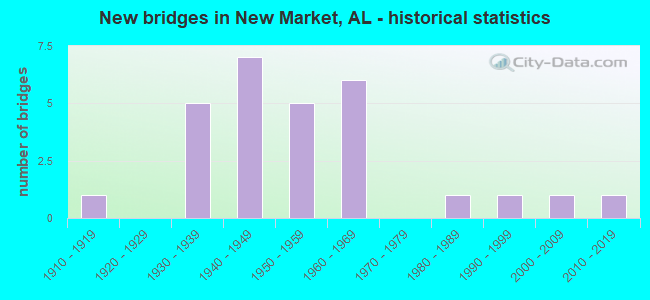
- New bridges - historical statistics
- 11910-1919
- 51930-1939
- 71940-1949
- 51950-1959
- 61960-1969
- 11980-1989
- 11990-1999
- 12000-2009
- 12010-2019

- Reconstructed bridges - Historical Statistics
- 11940-1949
- 01950-1959
- 01960-1969
- 11970-1979
- 11980-1989


- Bridge Condition - Deck
- 17.6%Excellent
- 5.9%Good
- 47.1%Satisfactory
- 29.4%Fair

- Bridge Condition - Superstructure
- 11.8%Excellent
- 5.9%Very good
- 47.1%Satisfactory
- 35.3%Fair

- Bridge Condition - Substructure
- 17.6%Excellent
- 5.9%Good
- 23.5%Satisfactory
- 47.1%Fair
- 5.9%Poor

- Bridge Condition - Channel
- 3.6%Excellent
- 7.1%Very good
- 7.1%Good
- 39.3%Satisfactory
- 39.3%Fair
- 3.6%Poor

- Bridge Condition - Culverts
- 9.1%Very good
- 9.1%Good
- 63.6%Satisfactory
- 18.2%Fair
Find on map >> Show street view
Structure Number: 1142, Location: 0.5 MI SO JCT CO RD 487 (Lat: 34.952747, Lng: -86.482350), Route carried "on" structure: County highway 257, Year Built: 1934, Status: Posted for load, Structure Length: 0.94m (3.08ft), Average Daily Traffic: 1,138 (year 2002), Truck Traffic: 1%, Average Future Daily Traffic: 1,365 (year 2034), Design Load: H 15, Features Intersected: SWAMP BRANCH, Facility Carried by Structure: BUTLER RD
Minimum Vertical Clearance: 30+ m (98+ ft), Kilometerpoint: 0.010, Lanes on structure: 2, Owner: County Highway Agency, Approaching Roadway Width: 8.5m (27.9ft), Material/Design: Steel, Design/Construction: Stringer/Multi-beam, Number Of Spans In Main Unit: 1, Length of Maximum Span: 9.4m (30.8ft), Curb-To-Curb Width: 5.9m (19.4ft), Out-to-Out Width: 6.8m (22.3ft)
Condition: Deck: Satisfactory, Superstructure: Satisfactory, Substructure: Satisfactory, Channel: Fair, Operating Rating: 19.9 metric tons, Method Used To Determine Operating Rating: Allowable Stress (AS), Inventory Rating: 9.0 metric tons, Method Used To Determine Inventory Rating: Allowable Stress (AS), Structural Evaluation: High priority of replacement, Deck Geometry: High priority of replacement, Waterway Adequacy: Equal to present minimum criteria, Approach Roadway Alignment: Equal to present minimum criteria, Bridge Posting: Required (Relationship of Operating Rating to Maximum Legal Load: > 39.9% below), Length Of Structure Improvement: 1.61m (5.28ft), Designated Inspection Frequency: Every 24 months, Other Special Inspection Frequency: Every 12 months, Inspection Date: May 2020, Other Special Inspection Date: May 2021, Bridge Improvement Cost: $243,000, Roadway Improvement Cost: $24,000, Total Project Cost: $267,000 ( Estimate for 2022), Deck Structure Type: Concrete Cast-file-Place, Wearing Surface/Protective System: Wearing Surface: Bituminous
Find on map >> Show street view
Structure Number: 1677, Location: 0.5 W JCT CO RD 305 (Lat: 34.880433, Lng: -86.455142), Route carried "on" structure: County highway 453, Year Built: 1937, Status: Open, Structure Length: 0.94m (3.08ft), Average Daily Traffic: 600 (year 1992), Truck Traffic: 1%, Average Future Daily Traffic: 730 (year 2034), Design Load: H 15, Features Intersected: RICE BRANCH, Facility Carried by Structure: OSCAR PATTERSON R
Minimum Vertical Clearance: 30+ m (98+ ft), Kilometerpoint: 0.010, Lanes on structure: 2, Owner: County Highway Agency, Approaching Roadway Width: 8.5m (27.9ft), Material/Design: Masonry, Design/Construction: Culvert, Number Of Spans In Main Unit: 2, Length of Maximum Span: 4.9m (16.1ft), Curb-To-Curb Width: 11.6m (38.1ft), Out-to-Out Width: 12.1m (39.7ft)
Condition: Channel: Fair, Culverts: Fair, Operating Rating: 32.7 metric tons, Method Used To Determine Operating Rating: Field evaluation and documented engineering judgment, Inventory Rating: 23.6 metric tons, Method Used To Determine Inventory Rating: Field evaluation and documented engineering judgment, Structural Evaluation: Somewhat better than minimum adequacy, Deck Geometry: Better than present minimum criteria, Waterway Adequacy: Somewhat better than minimum adequacy, Approach Roadway Alignment: Better than present minimum criteria, Length Of Structure Improvement: 1.61m (5.28ft), Designated Inspection Frequency: Every 24 months, Inspection Date: August 2020, Bridge Improvement Cost: $501,000, Roadway Improvement Cost: $50,000, Total Project Cost: $551,000 ( Estimate for 2022)
Find on map >> Show street view
Structure Number: 1679, Location: 2.3 MI JCT CO RD FAP116 (Lat: 34.836675, Lng: -86.421261), Route carried "on" structure: County highway 469, Year Built: 1937, Status: Open, Structure Length: 1.01m (3.31ft), Average Daily Traffic: 600 (year 1992), Truck Traffic: 1%, Average Future Daily Traffic: 780 (year 2040), Design Load: H 15, Features Intersected: ELDER BRANCH, Facility Carried by Structure: COUNTY LAKE RD
Minimum Vertical Clearance: 30+ m (98+ ft), Kilometerpoint: 0.010, Lanes on structure: 2, Owner: County Highway Agency, Approaching Roadway Width: 8.5m (27.9ft), Skew: 4 degrees, Material/Design: Masonry, Design/Construction: Culvert, Number Of Spans In Main Unit: 2, Length of Maximum Span: 5.2m (17.1ft), Curb-To-Curb Width: 6.2m (20.3ft), Out-to-Out Width: 6.7m (22.0ft)
Condition: Channel: Satisfactory, Culverts: Satisfactory, Operating Rating: 32.7 metric tons, Method Used To Determine Operating Rating: Field evaluation and documented engineering judgment, Inventory Rating: 23.6 metric tons, Method Used To Determine Inventory Rating: Field evaluation and documented engineering judgment, Structural Evaluation: Equal to present minimum criteria, Deck Geometry: High priority of corrective action, Waterway Adequacy: Equal to present minimum criteria, Approach Roadway Alignment: Equal to present minimum criteria, Length Of Structure Improvement: 1.68m (5.51ft), Designated Inspection Frequency: Every 24 months, Inspection Date: January 2021, Bridge Improvement Cost: $291,000, Roadway Improvement Cost: $29,000, Total Project Cost: $320,000 ( Estimate for 2022)
Find on map >> Show street view
Structure Number: 2079, Location: 2.0 MI N JCT CO RD 415 (Lat: 34.820919, Lng: -86.363222), Route carried "on" structure: County highway 416, Year Built: 1939, Status: Open, Structure Length: 0.88m (2.89ft), Average Daily Traffic: 35 (year 1992), Average Future Daily Traffic: 55 (year 2040), Design Load: H 15, Features Intersected: MOLDER CREEK, Facility Carried by Structure: SHARPES COVE RD
Minimum Vertical Clearance: 30+ m (98+ ft), Kilometerpoint: 0.010, Lanes on structure: 2, Owner: County Highway Agency, Approaching Roadway Width: 7.3m (24.0ft), Skew: 1 degrees, Material/Design: Concrete, Design/Construction: Tee Beam, Number Of Spans In Main Unit: 1, Length of Maximum Span: 8.8m (28.9ft), Curb-To-Curb Width: 6.1m (20.0ft), Out-to-Out Width: 6.7m (22.0ft)
Condition: Deck: Satisfactory, Superstructure: Fair, Substructure: Fair, Channel: Fair, Operating Rating: 42.3 metric tons, Method Used To Determine Operating Rating: Load Factor (LF), Inventory Rating: 25.3 metric tons, Method Used To Determine Inventory Rating: Load Factor (LF), Structural Evaluation: Somewhat better than minimum adequacy, Deck Geometry: Somewhat better than minimum adequacy, Waterway Adequacy: Somewhat better than minimum adequacy, Approach Roadway Alignment: Somewhat better than minimum adequacy, Length Of Structure Improvement: 1.55m (5.09ft), Designated Inspection Frequency: Every 24 months, Inspection Date: December 2020, Bridge Improvement Cost: $223,000, Roadway Improvement Cost: $22,000, Total Project Cost: $245,000 ( Estimate for 2022), Deck Structure Type: Concrete Cast-file-Place
Find on map >> Show street view
Structure Number: 208, Location: 0.2 MI EAST CO RD 1468 (Lat: 34.801858, Lng: -86.403397), Route carried "on" structure: County highway 433, Year Built: 1939, Status: Posted for load, Structure Length: 6.43m (21.10ft), Average Daily Traffic: 927 (year 2001), Truck Traffic: 1%, Average Future Daily Traffic: 1,112 (year 2040), Features Intersected: HURRICANE CREEK, Facility Carried by Structure: COUNTY LAKE RD
Minimum Vertical Clearance: 30+ m (98+ ft), Kilometerpoint: 0.010, Lanes on structure: 2, Owner: County Highway Agency, Approaching Roadway Width: 6.7m (22.0ft), Material/Design: Steel, Design/Construction: Stringer/Multi-beam, Number Of Spans In Main Unit: 2, Number Of Approach Spans: 5, Length of Maximum Span: 9.4m (30.8ft), Curb-To-Curb Width: 6.1m (20.0ft), Out-to-Out Width: 6.6m (21.7ft)
Condition: Deck: Fair, Superstructure: Fair, Substructure: Fair, Channel: Fair, Operating Rating: 29.9 metric tons, Method Used To Determine Operating Rating: Load Factor (LF), Inventory Rating: 18.0 metric tons, Method Used To Determine Inventory Rating: Load Factor (LF), Structural Evaluation: Somewhat better than minimum adequacy, Deck Geometry: High priority of corrective action, Waterway Adequacy: Somewhat better than minimum adequacy, Approach Roadway Alignment: Somewhat better than minimum adequacy, Bridge Posting: Required (Relationship of Operating Rating to Maximum Legal Load: 30.0 - 39.9% below), Length Of Structure Improvement: 7.47m (24.51ft), Designated Inspection Frequency: Every 24 months, Other Special Inspection Frequency: Every 12 months, Inspection Date: December 2020, Other Special Inspection Date: December 2021, Bridge Improvement Cost: $1,076,000, Roadway Improvement Cost: $108,000, Total Project Cost: $1,184,000 ( Estimate for 2022), Deck Structure Type: Concrete Cast-file-Place
Find on map >> Show street view
Structure Number: 2486, Location: 0.7 MI SO CO RD 1469 (Lat: 34.832139, Lng: -86.455364), Route carried "on" structure: County highway 258, Year Built: 1940, Status: Open, Structure Length: 1.19m (3.90ft), Average Daily Traffic: 600 (year 1992), Truck Traffic: 1%, Average Future Daily Traffic: 890 (year 2035), Design Load: H 15, Features Intersected: BURDINE CREEK, Facility Carried by Structure: MAYSVILLE RD
Minimum Vertical Clearance: 30+ m (98+ ft), Kilometerpoint: 0.010, Lanes on structure: 2, Owner: County Highway Agency, Approaching Roadway Width: 9.1m (29.9ft), Material/Design: Concrete, Design/Construction: Slab, Number Of Spans In Main Unit: 2, Length of Maximum Span: 6.1m (20.0ft), Curb-To-Curb Width: 8.6m (28.2ft), Out-to-Out Width: 9.1m (29.9ft)
Condition: Deck: Satisfactory, Superstructure: Satisfactory, Substructure: Fair, Channel: Fair, Operating Rating: 43.5 metric tons, Method Used To Determine Operating Rating: Field evaluation and documented engineering judgment, Inventory Rating: 32.7 metric tons, Method Used To Determine Inventory Rating: Field evaluation and documented engineering judgment, Structural Evaluation: Somewhat better than minimum adequacy, Deck Geometry: Somewhat better than minimum adequacy, Waterway Adequacy: Equal to present minimum criteria, Approach Roadway Alignment: Equal to present minimum criteria, Length Of Structure Improvement: 1.86m (6.10ft), Designated Inspection Frequency: Every 24 months, Inspection Date: September 2020, Bridge Improvement Cost: $370,000, Roadway Improvement Cost: $37,000, Total Project Cost: $407,000 ( Estimate for 2022), Deck Structure Type: Concrete Cast-file-Place, Wearing Surface/Protective System: Wearing Surface: Bituminous
Find on map >> Show street view
Structure Number: 2501, Location: 0.5 MI FAP 116 (Lat: 34.843528, Lng: -86.454297), Route carried "on" structure: County highway 469, Year Built: 1940, Status: Open, Structure Length: 1.01m (3.31ft), Average Daily Traffic: 520 (year 1990), Truck Traffic: 1%, Average Future Daily Traffic: 780 (year 2040), Design Load: H 15, Features Intersected: SO FORK LAWLER BRANCH, Facility Carried by Structure: COUNTY LAKE RD
Minimum Vertical Clearance: 30+ m (98+ ft), Kilometerpoint: 0.010, Lanes on structure: 2, Owner: County Highway Agency, Approaching Roadway Width: 7.9m (25.9ft), Skew: 3 degrees, Material/Design: Masonry, Design/Construction: Culvert, Number Of Spans In Main Unit: 3, Length of Maximum Span: 2.4m (7.9ft), Curb-To-Curb Width: 6.3m (20.7ft), Out-to-Out Width: 6.7m (22.0ft)
Condition: Channel: Satisfactory, Culverts: Satisfactory, Operating Rating: 32.7 metric tons, Method Used To Determine Operating Rating: Field evaluation and documented engineering judgment, Inventory Rating: 23.6 metric tons, Method Used To Determine Inventory Rating: Field evaluation and documented engineering judgment, Structural Evaluation: Equal to present minimum criteria, Deck Geometry: High priority of corrective action, Waterway Adequacy: Somewhat better than minimum adequacy, Approach Roadway Alignment: Equal to present minimum criteria, Length Of Structure Improvement: 1.68m (5.51ft), Designated Inspection Frequency: Every 24 months, Inspection Date: January 2021, Bridge Improvement Cost: $233,000, Roadway Improvement Cost: $23,000, Total Project Cost: $256,000 ( Estimate for 2022)
Find on map >> Show street view
Structure Number: 2502, Location: 0.3 MI W CO RD 480 (Lat: 34.987056, Lng: -86.410636), Route carried "on" structure: County highway 477, Year Built: 1940, Status: Posted for load, Structure Length: 2.10m (6.89ft), Average Daily Traffic: 195 (year 1992), Truck Traffic: 1%, Average Future Daily Traffic: 210 (year 2035), Design Load: H 15, Features Intersected: JENNY RIVER, Facility Carried by Structure: STEEL LA
Minimum Vertical Clearance: 30+ m (98+ ft), Kilometerpoint: 0.010, Lanes on structure: 2, Owner: County Highway Agency, Approaching Roadway Width: 7.9m (25.9ft), Skew: 4 degrees, Material/Design: Concrete, Design/Construction: Tee Beam, Number Of Spans In Main Unit: 2, Length of Maximum Span: 10.7m (35.1ft), Curb-To-Curb Width: 7.3m (24.0ft), Out-to-Out Width: 7.8m (25.6ft)
Condition: Deck: Satisfactory, Superstructure: Satisfactory, Substructure: Satisfactory, Channel: Satisfactory, Operating Rating: 39.6 metric tons, Method Used To Determine Operating Rating: Load Factor (LF), Inventory Rating: 23.8 metric tons, Method Used To Determine Inventory Rating: Load Factor (LF), Structural Evaluation: Equal to present minimum criteria, Deck Geometry: Somewhat better than minimum adequacy, Waterway Adequacy: Better than present minimum criteria, Approach Roadway Alignment: Equal to present minimum criteria, Bridge Posting: Required (Relationship of Operating Rating to Maximum Legal Load: 0.1 - 9.9% below), Length Of Structure Improvement: 2.88m (9.45ft), Designated Inspection Frequency: Every 24 months, Other Special Inspection Frequency: Every 12 months, Inspection Date: Febuary 2022, Other Special Inspection Date: Febuary 2022, Bridge Improvement Cost: $493,000, Roadway Improvement Cost: $49,000, Total Project Cost: $542,000 ( Estimate for 2022), Deck Structure Type: Concrete Cast-file-Place
Find on map >> Show street view
Structure Number: 262, Location: 0.2 MI SO CO. RD 1448 (Lat: 34.845411, Lng: -86.453953), Route carried "on" structure: County highway 258, Year Built: 1941, Status: Open, Structure Length: 1.25m (4.10ft), Average Daily Traffic: 600 (year 1992), Truck Traffic: 1%, Average Future Daily Traffic: 800 (year 2040), Design Load: H 15, Features Intersected: LOCUST GROVE BRANCH, Facility Carried by Structure: MAYSVILLE RD
Minimum Vertical Clearance: 30+ m (98+ ft), Kilometerpoint: 0.010, Lanes on structure: 2, Owner: County Highway Agency, Approaching Roadway Width: 8.5m (27.9ft), Skew: 4 degrees, Material/Design: Masonry, Design/Construction: Culvert, Number Of Spans In Main Unit: 3, Length of Maximum Span: 2.4m (7.9ft), Curb-To-Curb Width: 6.2m (20.3ft), Out-to-Out Width: 6.6m (21.7ft)
Condition: Channel: Fair, Culverts: Fair, Operating Rating: 32.7 metric tons, Method Used To Determine Operating Rating: Field evaluation and documented engineering judgment, Inventory Rating: 23.6 metric tons, Method Used To Determine Inventory Rating: Field evaluation and documented engineering judgment, Structural Evaluation: Somewhat better than minimum adequacy, Deck Geometry: High priority of corrective action, Waterway Adequacy: Equal to present minimum criteria, Approach Roadway Alignment: Equal to present minimum criteria, Length Of Structure Improvement: 1.92m (6.30ft), Designated Inspection Frequency: Every 24 months, Inspection Date: January 2021, Bridge Improvement Cost: $333,000, Roadway Improvement Cost: $33,000, Total Project Cost: $366,000 ( Estimate for 2022)
Find on map >> Show street view
Structure Number: 2977, Location: 1.0 MI SOUTH TENN ST LI (Lat: 34.982433, Lng: -86.404550), Route carried "on" structure: County highway 305, Year Built: 1946, Status: Open, Structure Length: 0.67m (2.20ft), Average Daily Traffic: 3,500 (year 1992), Truck Traffic: 1%, Average Future Daily Traffic: 4,900 (year 2035), Design Load: H 15, Features Intersected: PRATER SPRING BR, Facility Carried by Structure: WINCHESTER RD
Minimum Vertical Clearance: 30+ m (98+ ft), Kilometerpoint: 0.010, Lanes on structure: 2, Owner: County Highway Agency, Approaching Roadway Width: 9.8m (32.2ft), Material/Design: Concrete, Design/Construction: Culvert, Number Of Spans In Main Unit: 2, Length of Maximum Span: 3.0m (9.8ft), Curb-To-Curb Width: 9.3m (30.5ft), Out-to-Out Width: 9.4m (30.8ft)
Condition: Channel: Satisfactory, Culverts: Satisfactory, Operating Rating: 71.9 metric tons, Method Used To Determine Operating Rating: Load Factor (LF), Inventory Rating: 43.2 metric tons, Method Used To Determine Inventory Rating: Load Factor (LF), Structural Evaluation: Equal to present minimum criteria, Deck Geometry: Meets minimum limits, Waterway Adequacy: Equal to present minimum criteria, Approach Roadway Alignment: Better than present minimum criteria, Length Of Structure Improvement: 1.30m (4.27ft), Designated Inspection Frequency: Every 24 months, Inspection Date: June 2020, Bridge Improvement Cost: $233,000, Roadway Improvement Cost: $23,000, Total Project Cost: $256,000 ( Estimate for 2022)
Find on map >> Show street view
Structure Number: 3942, Location: 0.3 MI NE JCT CO RD 485 (Lat: 34.977739, Lng: -86.451636), Route carried "on" structure: County highway 486, Year Built: 1950, Status: Open, Structure Length: 2.16m (7.09ft), Average Daily Traffic: 75 (year 1992), Average Future Daily Traffic: 62 (year 2035), Features Intersected: HESTER CREEK, Facility Carried by Structure: PHILLIPS RD
Minimum Vertical Clearance: 30+ m (98+ ft), Kilometerpoint: 0.010, Lanes on structure: 1, Owner: County Highway Agency, Approaching Roadway Width: 7.3m (24.0ft), Material/Design: Steel, Design/Construction: Stringer/Multi-beam, Number Of Spans In Main Unit: 2, Length of Maximum Span: 12.5m (41.0ft), Curb-To-Curb Width: 4.3m (14.1ft), Out-to-Out Width: 4.9m (16.1ft)
Condition: Deck: Excellent, Superstructure: Excellent, Substructure: Fair, Channel: Fair, Operating Rating: 82.1 metric tons, Method Used To Determine Operating Rating: Load Factor (LF), Inventory Rating: 49.2 metric tons, Method Used To Determine Inventory Rating: Load Factor (LF), Structural Evaluation: Somewhat better than minimum adequacy, Deck Geometry: Equal to present minimum criteria, Waterway Adequacy: Somewhat better than minimum adequacy, Approach Roadway Alignment: Somewhat better than minimum adequacy, Length Of Structure Improvement: 2.95m (9.68ft), Designated Inspection Frequency: Every 24 months, Inspection Date: December 2021, Bridge Improvement Cost: $324,000, Roadway Improvement Cost: $32,000, Total Project Cost: $356,000 ( Estimate for 2022), Deck Structure Type: Concrete Cast-file-Place
Find on map >> Show street view
Structure Number: 4501, Location: 0.1 MI E JCT CO RD 468 (Lat: 34.878972, Lng: -86.387164), Route carried "on" structure: County highway 436, Year Built: 1915, Year Reconstructed: 1953, Status: Posted for load, Structure Length: 1.83m (6.00ft), Average Daily Traffic: 125 (year 1992), Truck Traffic: 1%, Average Future Daily Traffic: 225 (year 2040), Features Intersected: HURRICANE CREEK, Facility Carried by Structure: SHARPES HOLLOW RD
Minimum Vertical Clearance: 30+ m (98+ ft), Kilometerpoint: 0.010, Lanes on structure: 2, Owner: County Highway Agency, Approaching Roadway Width: 6.7m (22.0ft), Material/Design: Steel, Design/Construction: Stringer/Multi-beam, Number Of Spans In Main Unit: 2, Length of Maximum Span: 9.1m (29.9ft), Curb-To-Curb Width: 5.9m (19.4ft), Out-to-Out Width: 6.2m (20.3ft)
Condition: Deck: Fair, Superstructure: Fair, Substructure: Fair, Channel: Fair, Operating Rating: 16.2 metric tons, Method Used To Determine Operating Rating: Load Factor (LF), Inventory Rating: 9.7 metric tons, Method Used To Determine Inventory Rating: Load Factor (LF), Structural Evaluation: High priority of replacement, Deck Geometry: High priority of corrective action, Waterway Adequacy: Somewhat better than minimum adequacy, Approach Roadway Alignment: Meets minimum limits, Bridge Posting: Required (Relationship of Operating Rating to Maximum Legal Load: > 39.9% below), Length Of Structure Improvement: 2.54m (8.33ft), Designated Inspection Frequency: Every 24 months, Other Special Inspection Frequency: Every 12 months, Inspection Date: December 2020, Other Special Inspection Date: December 2021, Bridge Improvement Cost: $349,000, Roadway Improvement Cost: $35,000, Total Project Cost: $384,000 ( Estimate for 2022), Deck Structure Type: Concrete Cast-file-Place
Find on map >> Show street view
Structure Number: 4708, Location: 0.4 MI N CO RD 1436 (Lat: 34.862092, Lng: -86.405297), Route carried "on" structure: County highway 468, Year Built: 1953, Status: Posted for load, Structure Length: 0.73m (2.40ft), Average Daily Traffic: 450 (year 1992), Truck Traffic: 1%, Average Future Daily Traffic: 710 (year 2040), Features Intersected: STILLHOUSE CREEK, Facility Carried by Structure: HURRICANE RD
Minimum Vertical Clearance: 30+ m (98+ ft), Kilometerpoint: 0.010, Lanes on structure: 2, Owner: County Highway Agency, Approaching Roadway Width: 7.9m (25.9ft), Skew: 2 degrees, Material/Design: Steel, Design/Construction: Stringer/Multi-beam, Number Of Spans In Main Unit: 1, Length of Maximum Span: 7.3m (24.0ft), Curb-To-Curb Width: 7.2m (23.6ft), Out-to-Out Width: 7.6m (24.9ft)
Condition: Deck: Satisfactory, Superstructure: Satisfactory, Substructure: Satisfactory, Channel: Satisfactory, Operating Rating: 20.8 metric tons, Method Used To Determine Operating Rating: Allowable Stress (AS), Inventory Rating: 11.7 metric tons, Method Used To Determine Inventory Rating: Allowable Stress (AS), Structural Evaluation: Meets minimum limits, Deck Geometry: Meets minimum limits, Waterway Adequacy: Equal to present minimum criteria, Approach Roadway Alignment: Somewhat better than minimum adequacy, Bridge Posting: Required (Relationship of Operating Rating to Maximum Legal Load: > 39.9% below), Length Of Structure Improvement: 1.38m (4.53ft), Designated Inspection Frequency: Every 24 months, Other Special Inspection Frequency: Every 12 months, Inspection Date: January 2021, Other Special Inspection Date: January 2022, Bridge Improvement Cost: $227,000, Roadway Improvement Cost: $23,000, Total Project Cost: $250,000 ( Estimate for 2022), Deck Structure Type: Concrete Cast-file-Place, Wearing Surface/Protective System: Wearing Surface: Bituminous
Find on map >> Show street view
Structure Number: 5372, Location: 1.6 MI NW OF PLEVNA (Lat: 34.984878, Lng: -86.423233), Route carried "on" structure: County highway 480, Year Built: 1955, Status: Posted for load, Structure Length: 2.32m (7.61ft), Average Daily Traffic: 125 (year 1992), Truck Traffic: 1%, Average Future Daily Traffic: 115 (year 2040), Design Load: H 15, Features Intersected: JENNY RIVER, Facility Carried by Structure: J B WALKER RD
Minimum Vertical Clearance: 30+ m (98+ ft), Kilometerpoint: 0.010, Lanes on structure: 2, Owner: County Highway Agency, Approaching Roadway Width: 6.2m (20.3ft), Material/Design: Concrete, Design/Construction: Tee Beam, Number Of Spans In Main Unit: 4, Length of Maximum Span: 5.8m (19.0ft), Curb-To-Curb Width: 6.2m (20.3ft), Out-to-Out Width: 6.7m (22.0ft)
Condition: Deck: Satisfactory, Superstructure: Satisfactory, Substructure: Poor, Channel: Poor, Operating Rating: 17.9 metric tons, Method Used To Determine Operating Rating: Load Factor (LF), Inventory Rating: 10.7 metric tons, Method Used To Determine Inventory Rating: Load Factor (LF), Structural Evaluation: High priority of replacement, Deck Geometry: Meets minimum limits, Waterway Adequacy: Equal to present minimum criteria, Approach Roadway Alignment: Equal to present minimum criteria, Bridge Posting: Required (Relationship of Operating Rating to Maximum Legal Load: > 39.9% below), Length Of Structure Improvement: 3.15m (10.33ft), Designated Inspection Frequency: Every 24 months, Other Special Inspection Frequency: Every 12 months, Inspection Date: Febuary 2022, Other Special Inspection Date: Febuary 2022, Bridge Improvement Cost: $454,000, Roadway Improvement Cost: $45,000, Total Project Cost: $499,000 ( Estimate for 2022), Deck Structure Type: Concrete Cast-file-Place
Find on map >> Show street view
Structure Number: 5684, Location: 0.8 MI EAST CO ROAD1468 (Lat: 34.837117, Lng: -86.402989), Route carried "on" structure: County highway 434, Year Built: 1956, Status: Posted for load, Structure Length: 2.19m (7.19ft), Average Daily Traffic: 250 (year 1992), Truck Traffic: 1%, Average Future Daily Traffic: 325 (year 2040), Design Load: H 15, Features Intersected: HURRICANE CREEK RELIEF, Facility Carried by Structure: COUNTY LAKE RD
Minimum Vertical Clearance: 30+ m (98+ ft), Kilometerpoint: 0.010, Lanes on structure: 2, Owner: County Highway Agency, Approaching Roadway Width: 7.3m (24.0ft), Material/Design: Concrete, Design/Construction: Channel Beam, Number Of Spans In Main Unit: 3, Number Of Approach Spans: 1, Length of Maximum Span: 5.8m (19.0ft), Curb-To-Curb Width: 6.1m (20.0ft), Out-to-Out Width: 6.6m (21.7ft)
Condition: Deck: Fair, Superstructure: Fair, Substructure: Fair, Channel: Fair, Operating Rating: 19.4 metric tons, Method Used To Determine Operating Rating: Load Factor (LF), Inventory Rating: 11.6 metric tons, Method Used To Determine Inventory Rating: Load Factor (LF), Structural Evaluation: Meets minimum limits, Deck Geometry: Meets minimum limits, Waterway Adequacy: Somewhat better than minimum adequacy, Approach Roadway Alignment: Somewhat better than minimum adequacy, Bridge Posting: Required (Relationship of Operating Rating to Maximum Legal Load: > 39.9% below), Length Of Structure Improvement: 2.99m (9.81ft), Designated Inspection Frequency: Every 24 months, Other Special Inspection Frequency: Every 12 months, Inspection Date: November 2020, Other Special Inspection Date: November 2021, Bridge Improvement Cost: $431,000, Roadway Improvement Cost: $43,000, Total Project Cost: $474,000 ( Estimate for 2022), Deck Structure Type: Concrete Cast-file-Place, Wearing Surface/Protective System: Wearing Surface: Bituminous
Find on map >> Show street view
Structure Number: 5686, Location: 0.2 MI S TN STATE LINE (Lat: 34.987981, Lng: -86.399561), Route carried "on" structure: County highway 481, Year Built: 1956, Status: Posted for load, Structure Length: 2.32m (7.61ft), Average Daily Traffic: 100 (year 1992), Average Future Daily Traffic: 92 (year 2042), Design Load: H 15, Features Intersected: JENNY RIVER, Facility Carried by Structure: HONEY DR
Minimum Vertical Clearance: 30+ m (98+ ft), Kilometerpoint: 0.010, Lanes on structure: 2, Owner: County Highway Agency, Approaching Roadway Width: 8.5m (27.9ft), Material/Design: Concrete, Design/Construction: Channel Beam, Number Of Spans In Main Unit: 4, Length of Maximum Span: 5.8m (19.0ft), Curb-To-Curb Width: 6.1m (20.0ft), Out-to-Out Width: 7.2m (23.6ft)
Condition: Deck: Fair, Superstructure: Fair, Substructure: Fair, Channel: Fair, Operating Rating: 23.6 metric tons, Method Used To Determine Operating Rating: Allowable Stress (AS), Inventory Rating: 15.4 metric tons, Method Used To Determine Inventory Rating: Allowable Stress (AS), Structural Evaluation: Meets minimum limits, Deck Geometry: Somewhat better than minimum adequacy, Waterway Adequacy: Equal to present minimum criteria, Approach Roadway Alignment: Somewhat better than minimum adequacy, Bridge Posting: Required (Relationship of Operating Rating to Maximum Legal Load: > 39.9% below), Length Of Structure Improvement: 3.15m (10.33ft), Designated Inspection Frequency: Every 24 months, Other Special Inspection Frequency: Every 12 months, Inspection Date: January 2022, Other Special Inspection Date: January 2022, Bridge Improvement Cost: $497,000, Roadway Improvement Cost: $50,000, Total Project Cost: $547,000 ( Estimate for 2022), Deck Structure Type: Concrete Precast Panels, Wearing Surface/Protective System: Wearing Surface: Bituminous
Find on map >> Show street view
Structure Number: 7184, Location: 0.5 MI EAST CO RD 1468 (Lat: 34.837111, Lng: -86.402997), Route carried "on" structure: County highway 434, Year Built: 1960, Status: Open, Structure Length: 1.95m (6.40ft), Average Daily Traffic: 250 (year 1992), Truck Traffic: 1%, Average Future Daily Traffic: 325 (year 2040), Design Load: H 15, Features Intersected: HURRICANE CREEK, Facility Carried by Structure: COUNTY LAKE RD
Minimum Vertical Clearance: 30+ m (98+ ft), Kilometerpoint: 0.010, Lanes on structure: 2, Owner: County Highway Agency, Approaching Roadway Width: 7.3m (24.0ft), Material/Design: Concrete, Design/Construction: Culvert, Number Of Spans In Main Unit: 5, Length of Maximum Span: 3.7m (12.1ft), Curb-To-Curb Width: 6.8m (22.3ft), Out-to-Out Width: 7.2m (23.6ft)
Condition: Channel: Satisfactory, Culverts: Satisfactory, Operating Rating: 41.7 metric tons, Method Used To Determine Operating Rating: Load Factor (LF), Inventory Rating: 24.9 metric tons, Method Used To Determine Inventory Rating: Load Factor (LF), Structural Evaluation: Equal to present minimum criteria, Deck Geometry: Meets minimum limits, Waterway Adequacy: Equal to present minimum criteria, Approach Roadway Alignment: Equal to present minimum criteria, Length Of Structure Improvement: 2.69m (8.83ft), Designated Inspection Frequency: Every 24 months, Inspection Date: November 2020, Bridge Improvement Cost: $373,000, Roadway Improvement Cost: $37,000, Total Project Cost: $410,000 ( Estimate for 2022)
Find on map >> Show street view
Structure Number: 7185, Location: 0.7 MI E JCT CO RD 468 (Lat: 34.852853, Lng: -86.398656), Route carried "on" structure: County highway 436, Year Built: 1960, Status: Open, Structure Length: 2.29m (7.51ft), Average Daily Traffic: 100 (year 1992), Average Future Daily Traffic: 165 (year 2040), Design Load: H 15, Features Intersected: HURRICANE CREEK, Facility Carried by Structure: RAY RD
Minimum Vertical Clearance: 30+ m (98+ ft), Kilometerpoint: 0.010, Lanes on structure: 2, Owner: County Highway Agency, Approaching Roadway Width: 8.5m (27.9ft), Material/Design: Concrete, Design/Construction: Culvert, Number Of Spans In Main Unit: 5, Length of Maximum Span: 4.6m (15.1ft), Curb-To-Curb Width: 6.8m (22.3ft), Out-to-Out Width: 7.3m (24.0ft)
Condition: Channel: Satisfactory, Culverts: Satisfactory, Operating Rating: 60.6 metric tons, Method Used To Determine Operating Rating: Load Factor (LF), Inventory Rating: 36.3 metric tons, Method Used To Determine Inventory Rating: Load Factor (LF), Structural Evaluation: Equal to present minimum criteria, Deck Geometry: Somewhat better than minimum adequacy, Waterway Adequacy: Equal to present minimum criteria, Approach Roadway Alignment: Somewhat better than minimum adequacy, Length Of Structure Improvement: 3.12m (10.24ft), Designated Inspection Frequency: Every 24 months, Inspection Date: December 2020, Bridge Improvement Cost: $432,000, Roadway Improvement Cost: $43,000, Total Project Cost: $475,000 ( Estimate for 2022)
Find on map >> Show street view
Structure Number: 8093, Location: 2.6 MI W JCT FAP 116 (Lat: 34.961183, Lng: -86.463144), Route carried "on" structure: County highway 487, Year Built: 1963, Year Reconstructed: 1993, Status: Posted for load, Structure Length: 9.33m (30.61ft), Average Daily Traffic: 705 (year 2002), Truck Traffic: 1%, Average Future Daily Traffic: 825 (year 2040), Design Load: H 15, Features Intersected: HESTER CREEK, Facility Carried by Structure: BUDDY WILLIAMSON
Minimum Vertical Clearance: 30+ m (98+ ft), Kilometerpoint: 0.010, Lanes on structure: 2, Owner: County Highway Agency, Approaching Roadway Width: 10.4m (34.1ft), Material/Design: Prestressed concrete, Design/Construction: Stringer/Multi-beam, Number Of Spans In Main Unit: 1, Number Of Approach Spans: 7, Length of Maximum Span: 20.7m (67.9ft), Curb-To-Curb Width: 7.3m (24.0ft), Out-to-Out Width: 8.9m (29.2ft)
Condition: Deck: Satisfactory, Superstructure: Fair, Substructure: Fair, Channel: Satisfactory, Operating Rating: 36.2 metric tons, Method Used To Determine Operating Rating: Load Factor (LF), Inventory Rating: 21.8 metric tons, Method Used To Determine Inventory Rating: Load Factor (LF), Structural Evaluation: Somewhat better than minimum adequacy, Deck Geometry: Meets minimum limits, Waterway Adequacy: Equal to present minimum criteria, Approach Roadway Alignment: Equal to present minimum criteria, Bridge Posting: Required (Relationship of Operating Rating to Maximum Legal Load: 0.1 - 9.9% below), Length Of Structure Improvement: 10.29m (33.76ft), Designated Inspection Frequency: Every 24 months, Other Special Inspection Frequency: Every 12 months, Inspection Date: November 2020, Other Special Inspection Date: November 2021, Bridge Improvement Cost: $2,046,000, Roadway Improvement Cost: $205,000, Total Project Cost: $2,251,000 ( Estimate for 2022), Deck Structure Type: Concrete Cast-file-Place
Find on map >> Show street view
Structure Number: 8922, Location: 0.2 MI N CO RD 1469 (Lat: 34.845903, Lng: -86.459408), Route carried "on" structure: County highway 305, Year Built: 1965, Status: Open, Structure Length: 0.67m (2.20ft), Average Daily Traffic: 4,000 (year 1992), Truck Traffic: 1%, Average Future Daily Traffic: 8,274 (year 2035), Design Load: H 15, Features Intersected: LAWLER BRANCH, Facility Carried by Structure: WINCHESTER RD
Minimum Vertical Clearance: 30+ m (98+ ft), Kilometerpoint: 0.010, Lanes on structure: 2, Owner: County Highway Agency, Approaching Roadway Width: 10.4m (34.1ft), Material/Design: Concrete, Design/Construction: Culvert, Number Of Spans In Main Unit: 2, Length of Maximum Span: 3.0m (9.8ft), Curb-To-Curb Width: 20.2m (66.3ft), Out-to-Out Width: 20.7m (67.9ft)
Condition: Channel: Satisfactory, Culverts: Satisfactory, Operating Rating: 76.0 metric tons, Method Used To Determine Operating Rating: Load Factor (LF), Inventory Rating: 45.6 metric tons, Method Used To Determine Inventory Rating: Load Factor (LF), Structural Evaluation: Equal to present minimum criteria, Deck Geometry: Superior to present desirable criteria, Waterway Adequacy: Equal to present minimum criteria, Approach Roadway Alignment: Equal to present minimum criteria, Length Of Structure Improvement: 1.30m (4.27ft), Designated Inspection Frequency: Every 24 months, Inspection Date: September 2020, Bridge Improvement Cost: $510,000, Roadway Improvement Cost: $51,000, Total Project Cost: $561,000 ( Estimate for 2022)
Find on map >> Show street view
Structure Number: 9819, Location: 0.4 MI S CO RD 1453 (Lat: 34.875656, Lng: -86.450142), Route carried "on" structure: County highway 305, Year Built: 1968, Status: Open, Structure Length: 0.67m (2.20ft), Average Daily Traffic: 3,900 (year 1990), Truck Traffic: 1%, Average Future Daily Traffic: 5,710 (year 2035), Design Load: H 15, Features Intersected: RICE BRANCH, Facility Carried by Structure: WINCHESTER RD
Minimum Vertical Clearance: 30+ m (98+ ft), Kilometerpoint: 0.010, Lanes on structure: 2, Owner: County Highway Agency, Approaching Roadway Width: 10.4m (34.1ft), Material/Design: Concrete, Design/Construction: Culvert, Number Of Spans In Main Unit: 2, Length of Maximum Span: 3.0m (9.8ft), Curb-To-Curb Width: 16.3m (53.5ft), Out-to-Out Width: 16.8m (55.1ft)
Condition: Channel: Good, Culverts: Good, Operating Rating: 88.9 metric tons, Method Used To Determine Operating Rating: Load Factor (LF), Inventory Rating: 77.7 metric tons, Method Used To Determine Inventory Rating: Load Factor (LF), Structural Evaluation: Better than present minimum criteria, Deck Geometry: Superior to present desirable criteria, Waterway Adequacy: Better than present minimum criteria, Approach Roadway Alignment: Equal to present minimum criteria, Length Of Structure Improvement: 1.30m (4.27ft), Designated Inspection Frequency: Every 24 months, Inspection Date: September 2020, Bridge Improvement Cost: $383,000, Roadway Improvement Cost: $38,000, Total Project Cost: $421,000 ( Estimate for 2022)
Find on map >> Show street view
Structure Number: 9825, Location: 1.9 MI NW OF PLEVNA (Lat: 34.985344, Lng: -86.428564), Route carried "on" structure: County highway 483, Year Built: 1968, Status: Open, Structure Length: 1.92m (6.30ft), Average Daily Traffic: 125 (year 1992), Truck Traffic: 1%, Average Future Daily Traffic: 103 (year 2035), Design Load: H 15, Features Intersected: JENNY RIVER, Facility Carried by Structure: SCHOOL HOUSE RD
Minimum Vertical Clearance: 30+ m (98+ ft), Kilometerpoint: 0.010, Lanes on structure: 2, Owner: County Highway Agency, Approaching Roadway Width: 7.9m (25.9ft), Skew: 3 degrees, Material/Design: Concrete, Design/Construction: Culvert, Number Of Spans In Main Unit: 5, Length of Maximum Span: 3.7m (12.1ft), Curb-To-Curb Width: 12.6m (41.3ft), Out-to-Out Width: 13.1m (43.0ft)
Condition: Channel: Satisfactory, Culverts: Satisfactory, Operating Rating: 41.9 metric tons, Method Used To Determine Operating Rating: Load Factor (LF), Inventory Rating: 25.1 metric tons, Method Used To Determine Inventory Rating: Load Factor (LF), Structural Evaluation: Equal to present minimum criteria, Deck Geometry: Superior to present desirable criteria, Waterway Adequacy: Equal to present minimum criteria, Approach Roadway Alignment: Equal to present minimum criteria, Length Of Structure Improvement: 2.65m (8.69ft), Designated Inspection Frequency: Every 24 months, Inspection Date: July 2020, Bridge Improvement Cost: $643,000, Roadway Improvement Cost: $64,000, Total Project Cost: $707,000 ( Estimate for 2022)
Find on map >> Show street view
Structure Number: 12671, Location: 1.5 MI NW NEW MARKET (Lat: 34.917997, Lng: -86.401222), Route carried "on" structure: County highway 466, Year Built: 1948, Year Reconstructed: 1982, Status: Open, Structure Length: 1.89m (6.20ft), Average Daily Traffic: 175 (year 1992), Truck Traffic: 1%, Average Future Daily Traffic: 95 (year 2040), Design Load: H 15, Features Intersected: MOUNTAIN FORK CREEK, Facility Carried by Structure: OLD MTN FORK RD
Minimum Vertical Clearance: 30+ m (98+ ft), Kilometerpoint: 0.010, Lanes on structure: 2, Owner: County Highway Agency, Approaching Roadway Width: 8.5m (27.9ft), Material/Design: Steel, Design/Construction: Stringer/Multi-beam, Number Of Spans In Main Unit: 2, Length of Maximum Span: 9.4m (30.8ft), Curb-To-Curb Width: 7.2m (23.6ft), Out-to-Out Width: 7.7m (25.3ft)
Condition: Deck: Satisfactory, Superstructure: Satisfactory, Substructure: Satisfactory, Channel: Satisfactory, Operating Rating: 73.5 metric tons, Method Used To Determine Operating Rating: Allowable Stress (AS), Inventory Rating: 51.1 metric tons, Method Used To Determine Inventory Rating: Allowable Stress (AS), Structural Evaluation: Equal to present minimum criteria, Deck Geometry: Meets minimum limits, Waterway Adequacy: Better than present minimum criteria, Approach Roadway Alignment: Better than present minimum criteria, Length Of Structure Improvement: 2.62m (8.60ft), Designated Inspection Frequency: Every 24 months, Inspection Date: December 2020, Bridge Improvement Cost: $448,000, Roadway Improvement Cost: $45,000, Total Project Cost: $493,000 ( Estimate for 2022), Deck Structure Type: Concrete Cast-file-Place
Find on map >> Show street view
Structure Number: 16104, Location: 3.0 MI W OF PLEVNA (Lat: 34.954044, Lng: -86.468533), Route carried "on" structure: County highway 256, Year Built: 1989, Status: Open, Structure Length: 1.01m (3.31ft), Average Daily Traffic: 420 (year 2003), Truck Traffic: 2%, Average Future Daily Traffic: 620 (year 2035), Design Load: HS 20, Features Intersected: SWAMP BRANCH, Facility Carried by Structure: MINT SPRINGS RD
Minimum Vertical Clearance: 30+ m (98+ ft), Kilometerpoint: 0.010, Lanes on structure: 2, Owner: County Highway Agency, Approaching Roadway Width: 10.4m (34.1ft), Material/Design: Concrete, Design/Construction: Culvert, Number Of Spans In Main Unit: 3, Length of Maximum Span: 3.0m (9.8ft), Curb-To-Curb Width: 12.8m (42.0ft), Out-to-Out Width: 13.4m (44.0ft)
Condition: Channel: Good, Culverts: Very good, Operating Rating: 88.9 metric tons, Method Used To Determine Operating Rating: Load Factor (LF), Inventory Rating: 61.0 metric tons, Method Used To Determine Inventory Rating: Load Factor (LF), Structural Evaluation: Equal to present desirable criteria, Deck Geometry: Superior to present desirable criteria, Waterway Adequacy: Better than present minimum criteria, Approach Roadway Alignment: Better than present minimum criteria, Length Of Structure Improvement: 1.68m (5.51ft), Designated Inspection Frequency: Every 24 months, Inspection Date: June 2020, Bridge Improvement Cost: $495,000, Roadway Improvement Cost: $50,000, Total Project Cost: $545,000 ( Estimate for 2022), Deck Structure Type: Concrete Cast-file-Place, Wearing Surface/Protective System: Wearing Surface: Bituminous
Find on map >> Show street view
Structure Number: 16391, Location: 0.3 MI W NEW MARKET (Lat: 34.910261, Lng: -86.437383), Route carried "on" structure: County highway 462, Year Built: 1995, Status: Open, Structure Length: 10.67m (35.01ft), Average Daily Traffic: 1,330 (year 2003), Truck Traffic: 5%, Average Future Daily Traffic: 1,600 (year 2034), Design Load: HS 20, Features Intersected: MTN FORK CREEK, Facility Carried by Structure: NEW MARKET RD
Minimum Vertical Clearance: 30+ m (98+ ft), Kilometerpoint: 0.010, Lanes on structure: 2, Owner: County Highway Agency, Approaching Roadway Width: 10.4m (34.1ft), Material/Design: Prestressed concrete, Design/Construction: Stringer/Multi-beam, Number Of Spans In Main Unit: 4, Length of Maximum Span: 32.0m (105.0ft), Curb-To-Curb Width: 8.5m (27.9ft), Out-to-Out Width: 9.8m (32.2ft)
Condition: Deck: Excellent, Superstructure: Very good, Substructure: Excellent, Channel: Very good, Operating Rating: 65.9 metric tons, Method Used To Determine Operating Rating: Load Factor (LF), Inventory Rating: 49.0 metric tons, Method Used To Determine Inventory Rating: Load Factor (LF), Structural Evaluation: Equal to present desirable criteria, Deck Geometry: Somewhat better than minimum adequacy, Waterway Adequacy: Equal to present desirable criteria, Approach Roadway Alignment: Equal to present desirable criteria, Length Of Structure Improvement: 11.57m (37.96ft), Designated Inspection Frequency: Every 24 months, Inspection Date: April 2020, Bridge Improvement Cost: $2,540,000, Roadway Improvement Cost: $254,000, Total Project Cost: $2,794,000 ( Estimate for 2022), Deck Structure Type: Concrete Cast-file-Place
Find on map >> Show street view
Structure Number: 1872, Location: NEW MARKET,AL???????????? (Lat: 34.914053, Lng: -86.427556), Route carried "on" structure: County highway 305, Year Built: 2003, Status: Open, Structure Length: 7.32m (24.02ft), Average Daily Traffic: 3,805 (year 1992), Truck Traffic: 2%, Average Future Daily Traffic: 4,230 (year 2035), Design Load: HS 20, Features Intersected: MOUNTAIN FORK CREEK, Facility Carried by Structure: WINCHESTER ROAD
Minimum Vertical Clearance: 30+ m (98+ ft), Kilometerpoint: 0.016, Lanes on structure: 2, Owner: County Highway Agency, Approaching Roadway Width: 11.8m (38.7ft), Material/Design: Prestressed concrete, Design/Construction: Stringer/Multi-beam, Length of Maximum Span: 12.2m (40.0ft), Curb-To-Curb Width: 13.0m (42.7ft), Out-to-Out Width: 13.1m (43.0ft)
Condition: Deck: Excellent, Superstructure: Excellent, Substructure: Excellent, Channel: Excellent, Operating Rating: 88.9 metric tons, Method Used To Determine Operating Rating: Load Factor (LF), Inventory Rating: 32.7 metric tons, Method Used To Determine Inventory Rating: Load Factor (LF), Structural Evaluation: Superior to present desirable criteria, Deck Geometry: Equal to present minimum criteria, Waterway Adequacy: Superior to present desirable criteria, Approach Roadway Alignment: Superior to present desirable criteria, Length Of Structure Improvement: 8.34m (27.36ft), Designated Inspection Frequency: Every 24 months, Inspection Date: June 2020, Bridge Improvement Cost: $2,402,000, Roadway Improvement Cost: $240,000, Total Project Cost: $2,642,000 ( Estimate for 2022), Deck Structure Type: Concrete Cast-file-Place, Wearing Surface/Protective System: Wearing Surface: Integral Concrete
Find on map >> Show street view
Structure Number: 20702, Location: 0.25 MI. WEST OF BUTLER (Lat: 34.961467, Lng: -86.488492), Route carried "on" structure: County highway 487, Year Built: 1940, Status: Posted for load, Structure Length: 0.76m (2.49ft), Average Daily Traffic: 100 (year 2012), Average Future Daily Traffic: 200 (year 2035), Features Intersected: SWAMP BRANCH CREEK, Facility Carried by Structure: BUDDYWILLIAMSONRD
Minimum Vertical Clearance: 30+ m (98+ ft), Kilometerpoint: 0.010, Lanes on structure: 2, Owner: County Highway Agency, Approaching Roadway Width: 6.1m (20.0ft), Material/Design: Steel, Design/Construction: Stringer/Multi-beam, Number Of Spans In Main Unit: 1, Length of Maximum Span: 7.6m (24.9ft), Curb-To-Curb Width: 6.1m (20.0ft), Out-to-Out Width: 6.7m (22.0ft)
Condition: Deck: Fair, Superstructure: Satisfactory, Substructure: Good, Channel: Very good, Operating Rating: 13.2 metric tons, Method Used To Determine Operating Rating: Load Factor (LF), Inventory Rating: 7.9 metric tons, Method Used To Determine Inventory Rating: Load Factor (LF), Structural Evaluation: High priority of corrective action, Deck Geometry: Somewhat better than minimum adequacy, Waterway Adequacy: Equal to present desirable criteria, Approach Roadway Alignment: Equal to present desirable criteria, Bridge Posting: Required (Relationship of Operating Rating to Maximum Legal Load: > 39.9% below), Length Of Structure Improvement: 1.41m (4.63ft), Designated Inspection Frequency: Every 24 months, Other Special Inspection Frequency: Every 12 months, Inspection Date: September 2020, Other Special Inspection Date: September 2021, Bridge Improvement Cost: $203,000, Roadway Improvement Cost: $20,000, Total Project Cost: $223,000 ( Estimate for 2022), Deck Structure Type: Corrugated Steel, Wearing Surface/Protective System: Wearing Surface: Bituminous
Find on map >> Show street view
Structure Number: 21519, Location: 3 mi. NE Jct.CO RD 468_ (Lat: 34.919233, Lng: -86.358861), Route carried "on" structure: County highway 437, Year Built: 2019, Status: Open, Structure Length: 1.04m (3.41ft), Average Daily Traffic: 74 (year 2003), Average Future Daily Traffic: 100 (year 2041), Design Load: HS 20, Features Intersected: Hurricane Creek
Minimum Vertical Clearance: 30+ m (98+ ft), Kilometerpoint: 0.010, Lanes on structure: 2, Owner: County Highway Agency, Approaching Roadway Width: 6.4m (21.0ft), Number Of Spans In Main Unit: 1, Length of Maximum Span: 10.4m (34.1ft), Curb-To-Curb Width: 6.4m (21.0ft), Out-to-Out Width: 7.0m (23.0ft)
Condition: Deck: Good, Superstructure: Satisfactory, Substructure: Excellent, Channel: Fair, Operating Rating: 51.8 metric tons, Method Used To Determine Operating Rating: Load Factor (LF), Inventory Rating: 31.0 metric tons, Method Used To Determine Inventory Rating: Load Factor (LF), Structural Evaluation: Equal to present minimum criteria, Waterway Adequacy: Somewhat better than minimum adequacy, Approach Roadway Alignment: High priority of replacement, Length Of Structure Improvement: 1.71m (5.61ft), Designated Inspection Frequency: Every 24 months, Inspection Date: November 2021, Bridge Improvement Cost: $269,000, Roadway Improvement Cost: $27,000, Total Project Cost: $296,000 ( Estimate for 2022), Deck Structure Type: Concrete Precast Panels, Wearing Surface/Protective System: Wearing Surface: Monolithic Concrete, Membrane: Other