Bridge Statistics for New Eagle, Pennsylvania (PA)
Condition, Traffic, Stress, Structural Evaluation, Project Costs
- National Bridge Inventory (NBI) Statistics
- 17Number of bridges
- 594ft / 181mTotal length
- $663,000Total costs
- 62,837Total average daily traffic
- 4,646Total average daily truck traffic
- National Bridge Inventory (NBI) Registered Bridges for New Eagle
- No street view available for this location
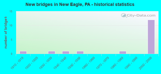
- New bridges - historical statistics
- 11910-1919
- 11930-1939
- 11940-1949
- 11950-1959
- 11980-1989
- 122000-2009


- Bridge Condition - Deck
- 10.0%Very good
- 60.0%Good
- 20.0%Satisfactory
- 10.0%Fair

- Bridge Condition - Superstructure
- 40.0%Very good
- 40.0%Good
- 20.0%Fair

- Bridge Condition - Substructure
- 70.0%Good
- 30.0%Fair

- Bridge Condition - Channel
- 25.0%Very good
- 25.0%Good
- 25.0%Satisfactory
- 12.5%Fair
- 12.5%Poor
Find on map >> Show street view
Structure Number: 34619, Location: CARROLL & UNION TOWNSHIP (Lat: 40.207867, Lng: -79.982264), Route carried "on" structure: State highway 88, Year Built: 1985, Status: Open, Structure Length: 2.71m (8.89ft), Average Daily Traffic: 1,850 (year 2020), Truck Traffic: 4%, Average Future Daily Traffic: 6,247 (year 2032), Design Load: HS 20+Mod, Features Intersected: MINGO CREEK
Minimum Vertical Clearance: 30+ m (98+ ft), Kilometerpoint: 46.399, Lanes on structure: 2, Base Highway Network: Yes, Owner: State Highway Agency, Approaching Roadway Width: 12.2m (40.0ft), Skew: 3 degrees, Material/Design: Prestressed concrete, Design/Construction: Box Beam or Girders - Multiple, Number Of Spans In Main Unit: 1, Length of Maximum Span: 26.8m (87.9ft), Curb or Sidewalk Widths: Left: 0.3m (1.0ft), Right: 0.3m (1.0ft), Curb-To-Curb Width: 12.2m (40.0ft), Out-to-Out Width: 13.3m (43.6ft)
Condition: Deck: Very good, Superstructure: Good, Substructure: Good, Channel: Good, Inventory Rating: 28.1 metric tons, Method Used To Determine Inventory Rating: Load Factor (LF), Structural Evaluation: Better than present minimum criteria, Deck Geometry: Better than present minimum criteria, Waterway Adequacy: Superior to present desirable criteria, Approach Roadway Alignment: Equal to present desirable criteria, Length Of Structure Improvement: 3.50m (11.48ft), Designated Inspection Frequency: Every 24 months, Inspection Date: September 2021, Deck Structure Type: Concrete Cast-file-Place, Wearing Surface/Protective System: Wearing Surface: Monolithic Concrete, Deck Protection: Epoxy Coated Reinforcing
Find on map >> Show street view
Structure Number: 3462, Location: UNION TOWNSHIP (Lat: 40.219186, Lng: -79.989800), Route carried "on" structure: State highway 88, Year Built: 1915, Year Reconstructed: 1952, Status: Open, Structure Length: 1.07m (3.51ft), Average Daily Traffic: 5,840 (year 2021), Truck Traffic: 11%, Average Future Daily Traffic: 6,907 (year 2032), Design Load: HS 20, Features Intersected: FROMAN RUN
Minimum Vertical Clearance: 30+ m (98+ ft), Kilometerpoint: 47.838, Lanes on structure: 2, Base Highway Network: Yes, Owner: State Highway Agency, Approaching Roadway Width: 9.1m (29.9ft), Skew: 4 degrees, Material/Design: Steel, Design/Construction: Stringer/Multi-beam, Number Of Spans In Main Unit: 1, Length of Maximum Span: 10.1m (33.1ft), Curb-To-Curb Width: 9.0m (29.5ft), Out-to-Out Width: 10.1m (33.1ft)
Condition: Deck: Satisfactory, Superstructure: Fair, Substructure: Fair, Channel: Fair, Operating Rating: 95.3 metric tons, Method Used To Determine Operating Rating: Load Factor (LF), Inventory Rating: 63.5 metric tons, Method Used To Determine Inventory Rating: Load Factor (LF), Structural Evaluation: Somewhat better than minimum adequacy, Deck Geometry: High priority of replacement, Waterway Adequacy: Superior to present desirable criteria, Approach Roadway Alignment: Equal to present desirable criteria, Length Of Structure Improvement: 1.00m (3.28ft), Designated Inspection Frequency: Every 24 months, Inspection Date: September 2021, Bridge Improvement Cost: $13,000, Roadway Improvement Cost: $100,000, Total Project Cost: $177,000, Deck Structure Type: Concrete Cast-file-Place, Wearing Surface/Protective System: Wearing Surface: Bituminous
Find on map >> Show street view
Structure Number: 34728, Location: NEW EAGLE BOROUGH (Lat: 40.213153, Lng: -79.961539), Route carried "on" structure: State highway 837, Year Built: 1931, Status: Open, Structure Length: 1.16m (3.81ft), Average Daily Traffic: 5,705 (year 2020), Truck Traffic: 3%, Average Future Daily Traffic: 5,971 (year 2032), Design Load: HS 20, Features Intersected: MINGO RUN
Minimum Vertical Clearance: 30+ m (98+ ft), Kilometerpoint: 13.610, Lanes on structure: 2, Owner: State Highway Agency, Approaching Roadway Width: 11.6m (38.1ft), Skew: 1 degrees, Material/Design: Concrete, Design/Construction: Culvert, Number Of Spans In Main Unit: 1, Length of Maximum Span: 9.1m (29.9ft)
Condition: Channel: Poor, Culverts: Poor, Inventory Rating: 99.8 metric tons, Method Used To Determine Inventory Rating: Load Factor (LF), Structural Evaluation: Meets minimum limits, Waterway Adequacy: Superior to present desirable criteria, Approach Roadway Alignment: Equal to present desirable criteria, Length Of Structure Improvement: 0.90m (2.95ft), Designated Inspection Frequency: Every 24 months, Underwater Inspection Frequency: Every 24 months, Inspection Date: October 2021, Underwater Inspection Date: September 2020, Bridge Improvement Cost: $23,000, Roadway Improvement Cost: $150,000, Total Project Cost: $312,000
Find on map >> Show street view
Structure Number: 34729, Location: UNION TOWNSHIP (Lat: 40.216297, Lng: -79.965900), Route carried "on" structure: State highway 837, Year Built: 1945, Status: Open, Structure Length: 1.22m (4.00ft), Average Daily Traffic: 5,705 (year 2020), Truck Traffic: 3%, Average Future Daily Traffic: 5,971 (year 2032), Design Load: HS 20, Features Intersected: MON-VIEW MINE TRACKS
Minimum Vertical Clearance: 30+ m (98+ ft), Kilometerpoint: 13.610, Lanes on structure: 2, Base Highway Network: Yes, Owner: Private, Approaching Roadway Width: 9.8m (32.2ft), Skew: 4 degrees, Material/Design: Concrete, Design/Construction: Tee Beam, Number Of Spans In Main Unit: 1, Length of Maximum Span: 11.0m (36.1ft), Curb-To-Curb Width: 12.2m (40.0ft), Out-to-Out Width: 13.1m (43.0ft)
Condition: Deck: Satisfactory, Superstructure: Good, Substructure: Fair, Operating Rating: 52.6 metric tons, Method Used To Determine Operating Rating: Load Factor (LF), Inventory Rating: 30.8 metric tons, Method Used To Determine Inventory Rating: Load Factor (LF), Structural Evaluation: Somewhat better than minimum adequacy, Deck Geometry: Somewhat better than minimum adequacy, Approach Roadway Alignment: Equal to present desirable criteria, Length Of Structure Improvement: 1.90m (6.23ft), Designated Inspection Frequency: Every 24 months, Inspection Date: October 2021, Bridge Improvement Cost: $13,000, Roadway Improvement Cost: $38,000, Total Project Cost: $174,000, Deck Structure Type: Concrete Cast-file-Place, Wearing Surface/Protective System: Wearing Surface: Bituminous
Find on map >> Show street view
Structure Number: 35317, Location: 150' SOUTH OF SR 1016 (Lat: 40.211342, Lng: -80.005897), Route carried "on" structure: City street , Year Built: 1950, Status: Posted for load, Structure Length: 1.31m (4.30ft), Average Daily Traffic: 400 (year 1993), Truck Traffic: 2%, Average Future Daily Traffic: 600 (year 2020), Design Load: HS 20, Features Intersected: MINGO CREEK TRIBUTARY, Facility Carried by Structure: NOTTINGHAM BRIDGE
Minimum Vertical Clearance: 30+ m (98+ ft), Kilometerpoint: 0.000, Lanes on structure: 2, Base Highway Network: Yes, Owner: County Highway Agency, Approaching Roadway Width: 5.8m (19.0ft), Material/Design: Steel, Design/Construction: Stringer/Multi-beam, Number Of Spans In Main Unit: 1, Length of Maximum Span: 12.8m (42.0ft), Curb-To-Curb Width: 7.3m (24.0ft), Out-to-Out Width: 7.9m (25.9ft)
Condition: Deck: Fair, Superstructure: Fair, Substructure: Fair, Channel: Satisfactory, Operating Rating: 40.8 metric tons, Method Used To Determine Operating Rating: Load Factor (LF), Inventory Rating: 24.5 metric tons, Method Used To Determine Inventory Rating: Load Factor (LF), Structural Evaluation: Somewhat better than minimum adequacy, Deck Geometry: Somewhat better than minimum adequacy, Waterway Adequacy: Equal to present desirable criteria, Approach Roadway Alignment: Equal to present desirable criteria, Bridge Posting: Required (Relationship of Operating Rating to Maximum Legal Load: 0.1 - 9.9% below), Length Of Structure Improvement: 2.00m (6.56ft), Designated Inspection Frequency: Every 24 months, Other Special Inspection Frequency: Every 12 months, Inspection Date: June 2021, Other Special Inspection Date: June 2021, Deck Structure Type: Closed Grating, Wearing Surface/Protective System: Wearing Surface: Bituminous, Membrane: Preformed Fabric
Find on map >> Show street view
Structure Number: 41223, Location: NEW EAGLE BOROUGH (Lat: 40.208711, Lng: -79.964636), Route carried "on" structure: State highway 88, Year Built: 2001, Status: Open, Structure Length: 2.90m (9.51ft), Average Daily Traffic: 1,850 (year 2020), Truck Traffic: 4%, Average Future Daily Traffic: 6,247 (year 2032), Design Load: HS 25 or greater, Features Intersected: MINGO CREEK
Minimum Vertical Clearance: 30+ m (98+ ft), Kilometerpoint: 44.252, Lanes on structure: 2, Base Highway Network: Yes, Owner: State Highway Agency, Approaching Roadway Width: 12.2m (40.0ft), Skew: 2 degrees, Material/Design: Prestressed concrete, Design/Construction: Stringer/Multi-beam, Number Of Spans In Main Unit: 1, Length of Maximum Span: 28.0m (91.9ft), Curb or Sidewalk Widths: Left: 0.2m (0.7ft), Right: 0.2m (0.7ft), Curb-To-Curb Width: 12.2m (40.0ft), Out-to-Out Width: 13.3m (43.6ft)
Condition: Deck: Good, Superstructure: Very good, Substructure: Good, Channel: Satisfactory, Inventory Rating: 46.3 metric tons, Method Used To Determine Inventory Rating: Load Factor (LF), Structural Evaluation: Better than present minimum criteria, Deck Geometry: Better than present minimum criteria, Waterway Adequacy: Superior to present desirable criteria, Approach Roadway Alignment: Equal to present desirable criteria, Length Of Structure Improvement: 3.70m (12.14ft), Designated Inspection Frequency: Every 48 months, Inspection Date: September 2019, Deck Structure Type: Corrugated Steel, Wearing Surface/Protective System: Wearing Surface: Monolithic Concrete, Deck Protection: Epoxy Coated Reinforcing
Find on map >> Show street view
Structure Number: 41865, Location: 2MI. NORTH OF RT136 INT. (Lat: 40.225000, Lng: -79.988889), Route carried "on" structure: Interstate 43, Year Built: 2001, Status: Open, Structure Length: 10.94m (35.89ft), Average Daily Traffic: 5,633 (year 2008), Truck Traffic: 4%, Average Future Daily Traffic: 7,324 (year 2030), Design Load: HS 25 or greater, Features Intersected: SR 1065
Minimum Vertical Clearance: 30+ m (98+ ft), Kilometerpoint: 0.000, Lanes on structure: 2, Lanes under structure: 2, Base Highway Network: Yes, Toll: On toll road, Owner: State Toll Authority, Approaching Roadway Width: 12.8m (42.0ft), Skew: 12 degrees, Material/Design: Steel continuous, Design/Construction: Stringer/Multi-beam, Number Of Spans In Main Unit: 3, Length of Maximum Span: 49.4m (162.1ft), Curb or Sidewalk Widths: Left: 0.2m (0.7ft), Right: 0.2m (0.7ft), Curb-To-Curb Width: 12.8m (42.0ft), Out-to-Out Width: 13.8m (45.3ft)
Condition: Deck: Good, Superstructure: Very good, Substructure: Good, Operating Rating: 79.8 metric tons, Method Used To Determine Operating Rating: Load Factor (LF), Inventory Rating: 48.1 metric tons, Method Used To Determine Inventory Rating: Load Factor (LF), Structural Evaluation: Better than present minimum criteria, Deck Geometry: Equal to present desirable criteria, Underclear: Meets minimum limits, Approach Roadway Alignment: Equal to present desirable criteria, Designated Inspection Frequency: Every 48 months, Inspection Date: April 2019, Deck Structure Type: Concrete Cast-file-Place, Wearing Surface/Protective System: Wearing Surface: Monolithic Concrete, Deck Protection: Epoxy Coated Reinforcing
Find on map >> Show street view
Structure Number: 41866, Location: 2MI. NORTH OF RT136 INT. (Lat: 40.225000, Lng: -79.988889), Route carried "on" structure: Interstate 43, Year Built: 2001, Status: Open, Structure Length: 5.09m (16.70ft), Average Daily Traffic: 5,533 (year 2008), Truck Traffic: 4%, Average Future Daily Traffic: 7,194 (year 2030), Design Load: HS 25 or greater, Features Intersected: SR 1065
Minimum Vertical Clearance: 30+ m (98+ ft), Kilometerpoint: 0.000, Lanes on structure: 2, Lanes under structure: 2, Base Highway Network: Yes, Toll: On toll road, Owner: State Toll Authority, Approaching Roadway Width: 12.8m (42.0ft), Skew: 12 degrees, Material/Design: Steel, Design/Construction: Stringer/Multi-beam, Number Of Spans In Main Unit: 1, Length of Maximum Span: 49.4m (162.1ft), Curb or Sidewalk Widths: Left: 0.2m (0.7ft), Right: 0.2m (0.7ft), Curb-To-Curb Width: 12.8m (42.0ft), Out-to-Out Width: 13.8m (45.3ft)
Condition: Deck: Good, Superstructure: Very good, Substructure: Good, Inventory Rating: 64.4 metric tons, Method Used To Determine Inventory Rating: Load Factor (LF), Structural Evaluation: Better than present minimum criteria, Deck Geometry: Equal to present desirable criteria, Underclear: Meets minimum limits, Approach Roadway Alignment: Equal to present desirable criteria, Designated Inspection Frequency: Every 48 months, Inspection Date: April 2019, Deck Structure Type: Concrete Cast-file-Place, Wearing Surface/Protective System: Wearing Surface: Monolithic Concrete, Deck Protection: Epoxy Coated Reinforcing
Find on map >> Show street view
Structure Number: 41972, Location: 0.75MI. N OF SR136 INT. (Lat: 40.208944, Lng: -79.984567), Route carried "on" structure: Other road 43, Year Built: 2000, Status: Open, Structure Length: 76.69m (251.61ft), Average Daily Traffic: 5,533 (year 2008), Truck Traffic: 4%, Average Future Daily Traffic: 7,194 (year 2030), Design Load: HS 25 or greater, Features Intersected: SR88&1087,W&LE,CK
Minimum Vertical Clearance: 30+ m (98+ ft), Kilometerpoint: 0.000, Lanes on structure: 2, Lanes under structure: 4, Base Highway Network: Yes, Toll: On toll road, Owner: State Toll Authority, Approaching Roadway Width: 12.8m (42.0ft), Skew: 10 degrees, Material/Design: Steel continuous, Design/Construction: Stringer/Multi-beam, Number Of Spans In Main Unit: 9, Length of Maximum Span: 91.4m (299.9ft), Curb or Sidewalk Widths: Left: 0.2m (0.7ft), Right: 0.2m (0.7ft), Curb-To-Curb Width: 12.8m (42.0ft), Out-to-Out Width: 13.8m (45.3ft)
Condition: Deck: Good, Superstructure: Good, Substructure: Good, Channel: Very good, Operating Rating: 69.9 metric tons, Method Used To Determine Operating Rating: Load Factor (LF), Inventory Rating: 41.7 metric tons, Method Used To Determine Inventory Rating: Load Factor (LF), Structural Evaluation: Better than present minimum criteria, Deck Geometry: Equal to present desirable criteria, Underclear: Equal to present minimum criteria, Waterway Adequacy: Superior to present desirable criteria, Approach Roadway Alignment: Equal to present desirable criteria, Designated Inspection Frequency: Every 48 months, Inspection Date: June 2019, Deck Structure Type: Concrete Cast-file-Place, Wearing Surface/Protective System: Wearing Surface: Monolithic Concrete, Deck Protection: Epoxy Coated Reinforcing
Find on map >> Show street view
Structure Number: 41973, Location: 0.75MI. N OF SR136 INT. (Lat: 40.209222, Lng: -79.984322), Route carried "on" structure: Other road 43, Year Built: 2000, Status: Open, Structure Length: 76.69m (251.61ft), Average Daily Traffic: 5,633 (year 2008), Truck Traffic: 4%, Average Future Daily Traffic: 7,324 (year 2030), Design Load: HS 25 or greater, Features Intersected: SR88&1087,W&LE,CK
Minimum Vertical Clearance: 30+ m (98+ ft), Kilometerpoint: 0.000, Lanes on structure: 2, Lanes under structure: 4, Base Highway Network: Yes, Toll: On toll road, Owner: State Toll Authority, Approaching Roadway Width: 12.8m (42.0ft), Skew: 10 degrees, Material/Design: Steel continuous, Design/Construction: Stringer/Multi-beam, Number Of Spans In Main Unit: 9, Length of Maximum Span: 91.4m (299.9ft), Curb or Sidewalk Widths: Left: 0.2m (0.7ft), Right: 0.2m (0.7ft), Curb-To-Curb Width: 12.8m (42.0ft), Out-to-Out Width: 13.8m (45.3ft)
Condition: Deck: Good, Superstructure: Good, Substructure: Good, Channel: Very good, Operating Rating: 78.0 metric tons, Method Used To Determine Operating Rating: Load Factor (LF), Inventory Rating: 47.2 metric tons, Method Used To Determine Inventory Rating: Load Factor (LF), Structural Evaluation: Better than present minimum criteria, Deck Geometry: Equal to present desirable criteria, Underclear: Equal to present minimum criteria, Waterway Adequacy: Superior to present desirable criteria, Approach Roadway Alignment: Equal to present desirable criteria, Designated Inspection Frequency: Every 48 months, Inspection Date: June 2019, Deck Structure Type: Concrete Cast-file-Place, Wearing Surface/Protective System: Wearing Surface: Monolithic Concrete, Deck Protection: Epoxy Coated Reinforcing
Find on map >> Show street view
Structure Number: 45476, Location: 0.2 MI S OF SR 0088 (Lat: 40.207567, Lng: -79.986128), Route carried "on" structure: State highway , Year Built: 2009, Status: Open, Structure Length: 1.49m (4.89ft), Average Daily Traffic: 1,573 (year 2022), Truck Traffic: 12%, Average Future Daily Traffic: 2,685 (year 2032), Design Load: HL 93, Features Intersected: MINGO CREEK, Facility Carried by Structure: SR 1087
Minimum Vertical Clearance: 30+ m (98+ ft), Kilometerpoint: 2.388, Lanes on structure: 2, Owner: State Highway Agency, Approaching Roadway Width: 8.8m (28.9ft), Material/Design: Prestressed concrete, Design/Construction: Box Beam or Girders - Multiple, Number Of Spans In Main Unit: 1, Length of Maximum Span: 14.3m (46.9ft), Curb or Sidewalk Widths: Left: 0.1m (0.3ft), Right: 0.1m (0.3ft), Curb-To-Curb Width: 8.8m (28.9ft), Out-to-Out Width: 9.8m (32.2ft)
Condition: Deck: Good, Superstructure: Very good, Substructure: Good, Channel: Good, Operating Rating: 57.2 metric tons, Method Used To Determine Operating Rating: Load and Resistance Factor (LRFR), Inventory Rating: 43.5 metric tons, Method Used To Determine Inventory Rating: Load and Resistance Factor (LRFR), Structural Evaluation: Better than present minimum criteria, Deck Geometry: Somewhat better than minimum adequacy, Waterway Adequacy: Superior to present desirable criteria, Approach Roadway Alignment: Equal to present desirable criteria, Designated Inspection Frequency: Every 48 months, Inspection Date: April 2020, Deck Structure Type: Concrete Cast-file-Place, Wearing Surface/Protective System: Wearing Surface: Monolithic Concrete, Deck Protection: Epoxy Coated Reinforcing
Find on map >> Show street view
Structure Number: 41865, Location: 2MI. NORTH OF RT136 INT. (Lat: 40.225000, Lng: -79.988889), Route carried "under" structure: State highway , Year Built: 2001, Structure Length: 0. m, Average Daily Traffic: 168 (year 2022), Truck Traffic: 9%, Features Intersected: SR 1065, Facility Carried by Structure: PA TPK (TOLL 43)
Minimum Vertical Clearance: 8.11m (26.61ft), Kilometerpoint: 0.000, Lanes on structure: 2, Lanes under structure: 2, Material/Design: Steel continuous, Design/Construction: Stringer/Multi-beam, Length of Maximum Span: 49.4m (162.1ft)
Find on map >> Show street view
Structure Number: 41866, Location: 2MI. NORTH OF RT136 INT. (Lat: 40.225000, Lng: -79.988889), Route carried "under" structure: State highway , Year Built: 2001, Structure Length: 0. m, Average Daily Traffic: 168 (year 2022), Truck Traffic: 9%, Features Intersected: SR 1065, Facility Carried by Structure: PA TPK (TOLL 43)
Minimum Vertical Clearance: 5.04m (16.54ft), Kilometerpoint: 0.000, Lanes on structure: 2, Lanes under structure: 2, Material/Design: Steel, Design/Construction: Stringer/Multi-beam, Length of Maximum Span: 49.4m (162.1ft)
Find on map >> Show street view
Structure Number: 41972, Location: 0.75MI. N OF SR136 INT. (Lat: 40.208944, Lng: -79.984567), Route carried "under" structure: State highway 88, Year Built: 2000, Structure Length: 0. m, Average Daily Traffic: 5,840 (year 2021), Truck Traffic: 11%, Features Intersected: SR88&1087,W&LE,CK, Facility Carried by Structure: PA TPK (TOLL 43)
Minimum Vertical Clearance: 30+ m (98+ ft), Kilometerpoint: 46.399, Lanes on structure: 2, Lanes under structure: 2, Material/Design: Steel continuous, Design/Construction: Stringer/Multi-beam, Length of Maximum Span: 91.4m (299.9ft)
Find on map >> Show street view
Structure Number: 41972, Location: 0.75MI. N OF SR136 INT. (Lat: 40.208944, Lng: -79.984567), Route carried "under" structure: State highway , Year Built: 2000, Structure Length: 0. m, Average Daily Traffic: 2,783 (year 2021), Truck Traffic: 20%, Features Intersected: SR88&1087,W&LE,CK, Facility Carried by Structure: PA TPK (TOLL 43)
Minimum Vertical Clearance: 30+ m (98+ ft), Kilometerpoint: 2.694, Lanes on structure: 2, Lanes under structure: 2, Material/Design: Steel continuous, Design/Construction: Stringer/Multi-beam, Length of Maximum Span: 91.4m (299.9ft)
Find on map >> Show street view
Structure Number: 41973, Location: 0.75MI. N OF SR136 INT. (Lat: 40.209222, Lng: -79.984322), Route carried "under" structure: State highway , Year Built: 2000, Structure Length: 0. m, Average Daily Traffic: 2,783 (year 2021), Truck Traffic: 20%, Features Intersected: SR88&1087,W&LE,CK, Facility Carried by Structure: PA TPK (TOLL 43)
Minimum Vertical Clearance: 30+ m (98+ ft), Kilometerpoint: 2.694, Lanes on structure: 2, Lanes under structure: 2, Material/Design: Steel continuous, Design/Construction: Stringer/Multi-beam, Length of Maximum Span: 91.4m (299.9ft)
Find on map >> Show street view
Structure Number: 41973, Location: 0.75MI. N OF SR136 INT. (Lat: 40.209222, Lng: -79.984322), Route carried "under" structure: State highway 88, Year Built: 2000, Structure Length: 0. m, Average Daily Traffic: 5,840 (year 2021), Truck Traffic: 11%, Features Intersected: SR88&1087,W&LE,CK, Facility Carried by Structure: PA TPK (TOLL 43)
Minimum Vertical Clearance: 30+ m (98+ ft), Kilometerpoint: 46.399, Lanes on structure: 2, Lanes under structure: 2, Material/Design: Steel continuous, Design/Construction: Stringer/Multi-beam, Length of Maximum Span: 91.4m (299.9ft)