Bridge Statistics for New California, Ohio (OH)
Condition, Traffic, Stress, Structural Evaluation, Project Costs
- National Bridge Inventory (NBI) Statistics
- 13Number of bridges
- 118ft / 36.5mTotal length
- 175,209Total average daily traffic
- 21,591Total average daily truck traffic
- National Bridge Inventory (NBI) Registered Bridges for New California
- No street view available for this location
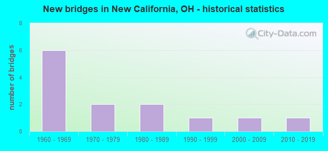
- New bridges - historical statistics
- 61960-1969
- 21970-1979
- 21980-1989
- 11990-1999
- 12000-2009
- 12010-2019


- Bridge Condition - Deck
- 33.3%Excellent
- 44.4%Very good
- 22.2%Good

- Bridge Condition - Superstructure
- 44.4%Excellent
- 22.2%Very good
- 33.3%Good

- Bridge Condition - Substructure
- 22.2%Excellent
- 33.3%Very good
- 33.3%Good
- 11.1%Fair

- Bridge Condition - Channel
- 14.3%Excellent
- 42.9%Very good
- 28.6%Good
- 14.3%Satisfactory
Find on map >> Show street view
Structure Number: 8001448, Location: 0.83 MI S OF US42 (Lat: 40.154300, Lng: -83.223039), Route carried "on" structure: County highway C0016, Year Built: 1967, Status: Open, Structure Length: 7.29m (23.92ft), Average Daily Traffic: 1,039 (year 2018), Truck Traffic: 8%, Average Future Daily Traffic: 64,951 (year 2038), Design Load: H 15, Features Intersected: OVER USR 33-2083, Facility Carried by Structure: CR 16
Minimum Vertical Clearance: 30+ m (98+ ft), Kilometerpoint: 0.772, Lanes on structure: 2, Lanes under structure: 4, Owner: State Highway Agency, Approaching Roadway Width: 9.8m (32.2ft), Skew: 1 degrees, Material/Design: Steel continuous, Design/Construction: Stringer/Multi-beam, Number Of Spans In Main Unit: 4, Length of Maximum Span: 21.0m (68.9ft), Curb-To-Curb Width: 7.3m (24.0ft), Out-to-Out Width: 9.1m (29.9ft)
Condition: Deck: Excellent, Superstructure: Very good, Substructure: Very good, Operating Rating: 42.1 metric tons, Method Used To Determine Operating Rating: Load Factor (LF) rating reported by rating factor (RF) method using MS18 loading, Inventory Rating: 29.2 metric tons, Method Used To Determine Inventory Rating: Load Factor (LF) rating reported by rating factor (RF) method using MS18 loading, Structural Evaluation: Better than present minimum criteria, Deck Geometry: Meets minimum limits, Underclear: High priority of corrective action, Approach Roadway Alignment: Equal to present desirable criteria, Designated Inspection Frequency: Every 24 months, Inspection Date: April 2021, Deck Structure Type: Concrete Cast-file-Place, Wearing Surface/Protective System: Wearing Surface: Monolithic Concrete
Find on map >> Show street view
Structure Number: 8001472, Location: 1.92 MI S OF US42 (Lat: 40.142989, Lng: -83.208650), Route carried "on" structure: County highway C0009, Year Built: 1967, Status: Open, Structure Length: 8.84m (29.00ft), Average Daily Traffic: 1,772 (year 2018), Truck Traffic: 5%, Average Future Daily Traffic: 64,951 (year 2038), Design Load: H 15, Features Intersected: US 33, Facility Carried by Structure: CR 9
Minimum Vertical Clearance: 30+ m (98+ ft), Kilometerpoint: 0.000, Lanes on structure: 2, Lanes under structure: 4, Owner: State Highway Agency, Approaching Roadway Width: 9.8m (32.2ft), Skew: 3 degrees, Material/Design: Steel continuous, Design/Construction: Stringer/Multi-beam, Number Of Spans In Main Unit: 4, Length of Maximum Span: 25.6m (84.0ft), Curb-To-Curb Width: 7.3m (24.0ft), Out-to-Out Width: 9.1m (29.9ft)
Condition: Deck: Very good, Superstructure: Good, Substructure: Good, Operating Rating: 42.1 metric tons, Method Used To Determine Operating Rating: Load Factor (LF) rating reported by rating factor (RF) method using MS18 loading, Inventory Rating: 25.9 metric tons, Method Used To Determine Inventory Rating: Load Factor (LF) rating reported by rating factor (RF) method using MS18 loading, Structural Evaluation: Equal to present minimum criteria, Deck Geometry: Meets minimum limits, Underclear: High priority of corrective action, Approach Roadway Alignment: Equal to present desirable criteria, Designated Inspection Frequency: Every 24 months, Inspection Date: April 2021, Deck Structure Type: Concrete Cast-file-Place, Wearing Surface/Protective System: Wearing Surface: Integral Concrete
Find on map >> Show street view
Structure Number: 8002355, Location: 1.2 MI S. OF OLD US33 (Lat: 40.141861, Lng: -83.248300), Route carried "on" structure: US 42, Year Built: 1985, Status: Open, Structure Length: 2.56m (8.40ft), Average Daily Traffic: 8,156 (year 2015), Truck Traffic: 15%, Average Future Daily Traffic: 11,321 (year 2035), Design Load: HS 20+Mod, Features Intersected: SUGAR RUN CREEK
Minimum Vertical Clearance: 30+ m (98+ ft), Kilometerpoint: 4.796, Lanes on structure: 2, Base Highway Network: Yes, Owner: State Highway Agency, Approaching Roadway Width: 9.8m (32.2ft), Skew: 2 degrees, Material/Design: Concrete continuous, Design/Construction: Slab, Number Of Spans In Main Unit: 3, Length of Maximum Span: 9.5m (31.2ft), Curb-To-Curb Width: 13.4m (44.0ft), Out-to-Out Width: 13.4m (44.0ft)
Condition: Deck: Good, Superstructure: Good, Substructure: Fair, Channel: Very good, Operating Rating: 35.6 metric tons, Method Used To Determine Operating Rating: Load Factor (LF) rating reported by rating factor (RF) method using MS18 loading, Inventory Rating: 29.2 metric tons, Method Used To Determine Inventory Rating: Load Factor (LF) rating reported by rating factor (RF) method using MS18 loading, Structural Evaluation: Somewhat better than minimum adequacy, Deck Geometry: Equal to present minimum criteria, Waterway Adequacy: Equal to present desirable criteria, Approach Roadway Alignment: Equal to present desirable criteria, Designated Inspection Frequency: Every 12 months, Inspection Date: June 2021, Deck Structure Type: Concrete Cast-file-Place, Wearing Surface/Protective System: Wearing Surface: Monolithic Concrete
Find on map >> Show street view
Structure Number: 8002371, Location: 0.4 MI N. OF OLD US 33 (Lat: 40.160861, Lng: -83.231889), Route carried "on" structure: US 42, Year Built: 1968, Status: Open, Structure Length: 7.22m (23.69ft), Average Daily Traffic: 9,094 (year 2015), Truck Traffic: 18%, Average Future Daily Traffic: 12,622 (year 2038), Design Load: HS 20+Mod, Features Intersected: OVER US-33
Minimum Vertical Clearance: 30+ m (98+ ft), Kilometerpoint: 7.371, Lanes on structure: 4, Lanes under structure: 4, Base Highway Network: Yes, Owner: State Highway Agency, Approaching Roadway Width: 25.6m (84.0ft), Skew: 20 degrees, Material/Design: Steel continuous, Design/Construction: Stringer/Multi-beam, Number Of Spans In Main Unit: 4, Length of Maximum Span: 20.7m (67.9ft), Curb-To-Curb Width: 21.9m (71.9ft), Out-to-Out Width: 23.2m (76.1ft)
Condition: Deck: Very good, Superstructure: Good, Substructure: Very good, Operating Rating: 35.6 metric tons, Method Used To Determine Operating Rating: Allowable Stress (AS) rating reported by rating factor (RF) method using MS18 loading, Inventory Rating: 32.4 metric tons, Method Used To Determine Inventory Rating: Allowable Stress (AS) rating reported by rating factor (RF) method using MS18 loading, Structural Evaluation: Better than present minimum criteria, Deck Geometry: Superior to present desirable criteria, Underclear: Equal to present minimum criteria, Approach Roadway Alignment: Equal to present desirable criteria, Designated Inspection Frequency: Every 24 months, Inspection Date: September 2021, Deck Structure Type: Concrete Cast-file-Place, Wearing Surface/Protective System: Wearing Surface: Integral Concrete
Find on map >> Show street view
Structure Number: 8002428, Location: 1.74 MI N. OF US33 (Lat: 40.180950, Lng: -83.211800), Route carried "on" structure: US 42, Year Built: 1989, Status: Open, Structure Length: 1.26m (4.13ft), Average Daily Traffic: 10,031 (year 2015), Truck Traffic: 20%, Average Future Daily Traffic: 13,923 (year 2038), Design Load: HS 20+Mod, Features Intersected: EVERSOLE RUN
Minimum Vertical Clearance: 30+ m (98+ ft), Kilometerpoint: 10.187, Lanes on structure: 2, Base Highway Network: Yes, Owner: State Highway Agency, Approaching Roadway Width: 9.8m (32.2ft), Material/Design: Prestressed concrete, Design/Construction: Box Beam or Girders - Multiple, Number Of Spans In Main Unit: 1, Length of Maximum Span: 12.2m (40.0ft), Curb-To-Curb Width: 12.2m (40.0ft), Out-to-Out Width: 12.2m (40.0ft)
Condition: Deck: Very good, Superstructure: Excellent, Substructure: Good, Channel: Very good, Operating Rating: 35.6 metric tons, Method Used To Determine Operating Rating: Allowable Stress (AS) rating reported by rating factor (RF) method using MS18 loading, Inventory Rating: 32.4 metric tons, Method Used To Determine Inventory Rating: Allowable Stress (AS) rating reported by rating factor (RF) method using MS18 loading, Structural Evaluation: Better than present minimum criteria, Deck Geometry: Somewhat better than minimum adequacy, Waterway Adequacy: Equal to present desirable criteria, Approach Roadway Alignment: Equal to present desirable criteria, Designated Inspection Frequency: Every 24 months, Inspection Date: March 2020, Deck Structure Type: Concrete Cast-file-Place, Wearing Surface/Protective System: Wearing Surface: Bituminous, Membrane: Built-up
Find on map >> Show street view
Structure Number: 8030243, Location: 0.97 MI SOUTH OF SR42 (Lat: 40.130281, Lng: -83.238189), Route carried "on" structure: County highway C0008, Year Built: 1970, Year Reconstructed: 2012, Status: Open, Structure Length: 1.80m (5.91ft), Average Daily Traffic: 721 (year 2015), Truck Traffic: 7%, Average Future Daily Traffic: 1,001 (year 2035), Design Load: HL 93, Features Intersected: SUGAR RUN, Facility Carried by Structure: CR 8 A CURRIER RD
Minimum Vertical Clearance: 30+ m (98+ ft), Kilometerpoint: 1.563, Lanes on structure: 2, Owner: County Highway Agency, Approaching Roadway Width: 8.5m (27.9ft), Material/Design: Prestressed concrete, Design/Construction: Box Beam or Girders - Multiple, Number Of Spans In Main Unit: 1, Length of Maximum Span: 17.1m (56.1ft), Curb-To-Curb Width: 9.8m (32.2ft), Out-to-Out Width: 9.8m (32.2ft)
Condition: Deck: Very good, Superstructure: Excellent, Substructure: Very good, Channel: Good, Operating Rating: 64.8 metric tons, Method Used To Determine Operating Rating: Load and Resistance Factor Rating (LRFR) rating reported by rating factor(RF) method using HL-93 loadings, Inventory Rating: 51.8 metric tons, Method Used To Determine Inventory Rating: Load and Resistance Factor Rating (LRFR) rating reported by rating factor(RF) method using HL-93 loadings, Structural Evaluation: Equal to present desirable criteria, Deck Geometry: Equal to present minimum criteria, Waterway Adequacy: Equal to present minimum criteria, Approach Roadway Alignment: Somewhat better than minimum adequacy, Designated Inspection Frequency: Every 24 months, Inspection Date: November 2021, Deck Structure Type: Concrete Cast-file-Place, Wearing Surface/Protective System: Wearing Surface: Bituminous
Find on map >> Show street view
Structure Number: 8030669, Location: 0.5 MI W. of INDUSTRIAL P (Lat: 40.158950, Lng: -83.254181), Route carried "on" structure: County highway C0033, Year Built: 1974, Status: Open, Structure Length: 2.13m (6.99ft), Average Daily Traffic: 1,084 (year 2015), Truck Traffic: 8%, Average Future Daily Traffic: 1,505 (year 2035), Design Load: HS 20+Mod, Features Intersected: SUGAR RUN, Facility Carried by Structure: CR 33 F TAYLOR RD
Minimum Vertical Clearance: 30+ m (98+ ft), Kilometerpoint: 6.029, Lanes on structure: 2, Owner: County Highway Agency, Approaching Roadway Width: 8.5m (27.9ft), Material/Design: Concrete continuous, Design/Construction: Slab, Number Of Spans In Main Unit: 3, Length of Maximum Span: 7.6m (24.9ft), Curb-To-Curb Width: 8.5m (27.9ft), Out-to-Out Width: 8.5m (27.9ft)
Condition: Deck: Good, Superstructure: Very good, Substructure: Good, Channel: Satisfactory, Operating Rating: 32.4 metric tons, Method Used To Determine Operating Rating: Load Factor (LF) rating reported by rating factor (RF) method using MS18 loading, Inventory Rating: 19.4 metric tons, Method Used To Determine Inventory Rating: Load Factor (LF) rating reported by rating factor (RF) method using MS18 loading, Structural Evaluation: Somewhat better than minimum adequacy, Deck Geometry: Somewhat better than minimum adequacy, Waterway Adequacy: Equal to present minimum criteria, Approach Roadway Alignment: Somewhat better than minimum adequacy, Designated Inspection Frequency: Every 24 months, Inspection Date: August 2021, Deck Structure Type: Concrete Cast-file-Place, Wearing Surface/Protective System: Wearing Surface: Monolithic Concrete
Find on map >> Show street view
Structure Number: 8036853, Location: 0.01 WEST of CURRIER RD (Lat: 40.128731, Lng: -83.237969), Route carried "on" structure: County highway C0023, Year Built: 2003, Status: Open, Structure Length: 2.68m (8.79ft), Average Daily Traffic: 431 (year 2015), Truck Traffic: 7%, Average Future Daily Traffic: 598 (year 2035), Design Load: HS 20+Mod, Features Intersected: SUGAR RUN, Facility Carried by Structure: C23B CONVERSE RD
Minimum Vertical Clearance: 30+ m (98+ ft), Kilometerpoint: 3.328, Lanes on structure: 2, Owner: County Highway Agency, Approaching Roadway Width: 6.7m (22.0ft), Material/Design: Prestressed concrete, Design/Construction: Box Beam or Girders - Multiple, Number Of Spans In Main Unit: 1, Length of Maximum Span: 26.2m (86.0ft), Curb-To-Curb Width: 9.1m (29.9ft), Out-to-Out Width: 9.1m (29.9ft)
Condition: Deck: Excellent, Superstructure: Excellent, Substructure: Excellent, Channel: Excellent, Operating Rating: 42.1 metric tons, Method Used To Determine Operating Rating: Load Factor (LF) rating reported by rating factor (RF) method using MS18 loading, Inventory Rating: 32.4 metric tons, Method Used To Determine Inventory Rating: Load Factor (LF) rating reported by rating factor (RF) method using MS18 loading, Structural Evaluation: Equal to present desirable criteria, Deck Geometry: Equal to present minimum criteria, Waterway Adequacy: Equal to present desirable criteria, Approach Roadway Alignment: Superior to present desirable criteria, Designated Inspection Frequency: Every 24 months, Inspection Date: November 2021, Deck Structure Type: Concrete Cast-file-Place, Wearing Surface/Protective System: Wearing Surface: Bituminous, Membrane: Preformed Fabric
Find on map >> Show street view
Structure Number: 8036861, Location: 0.18 MI SOUTH OF SR42 (Lat: 40.139811, Lng: -83.246111), Route carried "on" structure: County highway C0008, Year Built: 2013, Status: Open, Structure Length: 1.80m (5.91ft), Average Daily Traffic: 721 (year 2015), Truck Traffic: 7%, Average Future Daily Traffic: 1,001 (year 2035), Design Load: HL 93, Features Intersected: SUGAR RUN, Facility Carried by Structure: CR 8 A CURRIER RD
Minimum Vertical Clearance: 30+ m (98+ ft), Kilometerpoint: 0.303, Lanes on structure: 2, Owner: County Highway Agency, Approaching Roadway Width: 8.5m (27.9ft), Material/Design: Prestressed concrete, Design/Construction: Box Beam or Girders - Multiple, Number Of Spans In Main Unit: 1, Length of Maximum Span: 17.1m (56.1ft), Curb-To-Curb Width: 9.6m (31.5ft), Out-to-Out Width: 9.8m (32.2ft)
Condition: Deck: Excellent, Superstructure: Excellent, Substructure: Excellent, Channel: Very good, Operating Rating: 64.8 metric tons, Method Used To Determine Operating Rating: Load and Resistance Factor Rating (LRFR) rating reported by rating factor(RF) method using HL-93 loadings, Inventory Rating: 51.8 metric tons, Method Used To Determine Inventory Rating: Load and Resistance Factor Rating (LRFR) rating reported by rating factor(RF) method using HL-93 loadings, Structural Evaluation: Superior to present desirable criteria, Deck Geometry: Equal to present minimum criteria, Waterway Adequacy: Equal to present desirable criteria, Approach Roadway Alignment: Equal to present desirable criteria, Designated Inspection Frequency: Every 24 months, Inspection Date: November 2021, Deck Structure Type: Concrete Cast-file-Place, Wearing Surface/Protective System: Wearing Surface: Bituminous, Membrane: Preformed Fabric
Find on map >> Show street view
Structure Number: 8046409, Location: 0.90 MI NW SR 42 (Lat: 40.166681, Lng: -83.252331), Route carried "on" structure: County highway C0001, Year Built: 1993, Status: Open, Structure Length: 0.91m (2.99ft), Average Daily Traffic: 5,820 (year 2015), Truck Traffic: 7%, Average Future Daily Traffic: 8,078 (year 2035), Design Load: HS 20, Features Intersected: SUGAR RUN, Facility Carried by Structure: C1D INDUSTRIAL PK
Minimum Vertical Clearance: 30+ m (98+ ft), Kilometerpoint: 11.727, Lanes on structure: 2, Owner: County Highway Agency, Approaching Roadway Width: 7.3m (24.0ft), Material/Design: Concrete, Design/Construction: Culvert, Number Of Spans In Main Unit: 1, Length of Maximum Span: 8.5m (27.9ft)
Condition: Channel: Good, Culverts: Excellent, Operating Rating: 97.2 metric tons, Method Used To Determine Operating Rating: Load Factor (LF) rating reported by rating factor (RF) method using MS18 loading, Inventory Rating: 74.5 metric tons, Method Used To Determine Inventory Rating: Load Factor (LF) rating reported by rating factor (RF) method using MS18 loading, Structural Evaluation: Superior to present desirable criteria, Waterway Adequacy: Better than present minimum criteria, Approach Roadway Alignment: Equal to present minimum criteria, Designated Inspection Frequency: Every 24 months, Inspection Date: November 2021
Find on map >> Show street view
Structure Number: 8001448, Location: 0.83 MI S OF US42 (Lat: 40.154300, Lng: -83.223039), Route carried "under" structure: US 33, Year Built: 1967, Structure Length: 0. m, Average Daily Traffic: 46,795 (year 2015), Truck Traffic: 12%, Features Intersected: UNDER CR 16, Facility Carried by Structure: CR 16
Minimum Vertical Clearance: 4.65m (15.26ft), Kilometerpoint: 33.828, Lanes on structure: 2, Lanes under structure: 4, Material/Design: Steel continuous, Design/Construction: Stringer/Multi-beam, Length of Maximum Span: 21.0m (68.9ft)
Find on map >> Show street view
Structure Number: 8001472, Location: 1.92 MI S OF US42 (Lat: 40.142989, Lng: -83.208650), Route carried "under" structure: US 33, Year Built: 1967, Structure Length: 0. m, Average Daily Traffic: 46,795 (year 2015), Truck Traffic: 12%, Features Intersected: UNDER CR 9, Facility Carried by Structure: CR 9
Minimum Vertical Clearance: 4.52m (14.83ft), Kilometerpoint: 35.583, Lanes on structure: 2, Lanes under structure: 4, Material/Design: Steel continuous, Design/Construction: Stringer/Multi-beam, Length of Maximum Span: 25.6m (84.0ft)
Find on map >> Show street view
Structure Number: 8002371, Location: 0.4 MI N. OF OLD US 33 (Lat: 40.160861, Lng: -83.231889), Route carried "under" structure: US 33, Year Built: 1968, Structure Length: 0. m, Average Daily Traffic: 42,750 (year 2015), Truck Traffic: 11%, Features Intersected: UNDER US-42, Facility Carried by Structure: US 42
Minimum Vertical Clearance: 4.62m (15.16ft), Kilometerpoint: 32.782, Lanes on structure: 4, Lanes under structure: 4, Material/Design: Steel continuous, Design/Construction: Stringer/Multi-beam, Length of Maximum Span: 20.7m (67.9ft)