Bridge Statistics for New Britain, Pennsylvania (PA)
Condition, Traffic, Stress, Structural Evaluation, Project Costs
- National Bridge Inventory (NBI) Statistics
- 22Number of bridges
- 194ft / 58.9mTotal length
- $3,714,000Total costs
- 193,579Total average daily traffic
- 12,025Total average daily truck traffic
- National Bridge Inventory (NBI) Registered Bridges for New Britain
- No street view available for this location
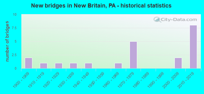
- New bridges - historical statistics
- 21900-1909
- 11910-1919
- 11920-1929
- 11930-1939
- 11940-1949
- 11960-1969
- 51970-1979
- 22000-2009
- 82010-2019


- Bridge Condition - Deck
- 46.2%Very good
- 7.7%Good
- 23.1%Satisfactory
- 7.7%Fair
- 15.4%Poor

- Bridge Condition - Superstructure
- 38.5%Very good
- 7.7%Satisfactory
- 38.5%Fair
- 15.4%Poor

- Bridge Condition - Substructure
- 23.1%Very good
- 15.4%Good
- 23.1%Satisfactory
- 23.1%Fair
- 15.4%Poor

- Bridge Condition - Channel
- 6.7%Very good
- 13.3%Good
- 26.7%Satisfactory
- 20.0%Fair
- 33.3%Poor

- Bridge Condition - Culverts
- 60.0%Good
- 40.0%Satisfactory
Find on map >> Show street view
Structure Number: 6915, Location: CHALFONT; 27K03/3033H04 (Lat: 40.287994, Lng: -75.204725), Route carried "on" structure: State highway , Year Built: 1948, Status: Open, Structure Length: 4.18m (13.71ft), Average Daily Traffic: 13,117 (year 2021), Truck Traffic: 4%, Average Future Daily Traffic: 23,639 (year 2032), Design Load: HS 20, Features Intersected: NORTH BR.NESHAMINY CREEK, Facility Carried by Structure: BUTLER AVENUE
Minimum Vertical Clearance: 30+ m (98+ ft), Kilometerpoint: 2.923, Lanes on structure: 2, Base Highway Network: Yes, Owner: State Highway Agency, Approaching Roadway Width: 11.6m (38.1ft), Skew: 4 degrees, Material/Design: Concrete, Design/Construction: Tee Beam, Number Of Spans In Main Unit: 3, Length of Maximum Span: 14.3m (46.9ft), Curb or Sidewalk Widths: Left: 1.5m (4.9ft), Right: 1.5m (4.9ft), Curb-To-Curb Width: 8.5m (27.9ft), Out-to-Out Width: 11.8m (38.7ft)
Condition: Deck: Fair, Superstructure: Fair, Substructure: Poor, Channel: Poor, Operating Rating: 54.4 metric tons, Method Used To Determine Operating Rating: Load Factor (LF), Inventory Rating: 32.7 metric tons, Method Used To Determine Inventory Rating: Load Factor (LF), Structural Evaluation: Meets minimum limits, Deck Geometry: High priority of replacement, Waterway Adequacy: Equal to present minimum criteria, Approach Roadway Alignment: Better than present minimum criteria, Length Of Structure Improvement: 5.10m (16.73ft), Designated Inspection Frequency: Every 24 months, Inspection Date: March 2021, Bridge Improvement Cost: $69,000, Roadway Improvement Cost: $202,000, Total Project Cost: $927,000, Deck Structure Type: Concrete Cast-file-Place, Wearing Surface/Protective System: Wearing Surface: Bituminous
Find on map >> Show street view
Structure Number: 6916, Location: NEW BRITIAN BORO. 28E01 (Lat: 40.300861, Lng: -75.169667), Route carried "on" structure: State highway , Year Built: 1926, Status: Posted for load, Structure Length: 1.04m (3.41ft), Average Daily Traffic: 9,913 (year 2021), Truck Traffic: 3%, Average Future Daily Traffic: 24,783 (year 2032), Design Load: H 15, Features Intersected: COOKS RUN, Facility Carried by Structure: E. BUTLER AVENUE
Minimum Vertical Clearance: 30+ m (98+ ft), Kilometerpoint: 6.061, Lanes on structure: 2, Base Highway Network: Yes, Owner: State Highway Agency, Approaching Roadway Width: 12.8m (42.0ft), Skew: 4 degrees, Material/Design: Concrete, Design/Construction: Tee Beam, Number Of Spans In Main Unit: 1, Length of Maximum Span: 9.8m (32.2ft), Curb or Sidewalk Widths: Left: 0.2m (0.7ft), Right: 0.2m (0.7ft), Curb-To-Curb Width: 12.2m (40.0ft), Out-to-Out Width: 12.8m (42.0ft)
Condition: Deck: Poor, Superstructure: Poor, Substructure: Fair, Channel: Poor, Operating Rating: 42.6 metric tons, Method Used To Determine Operating Rating: Load Factor (LF), Inventory Rating: 25.4 metric tons, Method Used To Determine Inventory Rating: Load Factor (LF), Structural Evaluation: Meets minimum limits, Deck Geometry: Somewhat better than minimum adequacy, Waterway Adequacy: Equal to present minimum criteria, Approach Roadway Alignment: Better than present minimum criteria, Length Of Structure Improvement: 1.60m (5.25ft), Designated Inspection Frequency: Every 24 months, Other Special Inspection Frequency: Every 12 months, Inspection Date: January 2021, Other Special Inspection Date: January 2021, Bridge Improvement Cost: $24,000, Roadway Improvement Cost: $72,000, Total Project Cost: $329,000, Deck Structure Type: Concrete Cast-file-Place, Wearing Surface/Protective System: Wearing Surface: Integral Concrete
Find on map >> Show street view
Structure Number: 6917, Location: 1MI.S.DOYLESTOWN 22H13 (Lat: 40.302722, Lng: -75.148917), Route carried "on" structure: State highway , Year Built: 1975, Status: Open, Structure Length: 8.26m (27.10ft), Average Daily Traffic: 14,959 (year 2022), Truck Traffic: 6%, Average Future Daily Traffic: 30,609 (year 2032), Design Load: HS 20, Features Intersected: PA 611 BY PASS, Facility Carried by Structure: BUTLER PIKE
Minimum Vertical Clearance: 30+ m (98+ ft), Kilometerpoint: 7.730, Lanes on structure: 2, Lanes under structure: 6, Base Highway Network: Yes, Owner: State Highway Agency, Approaching Roadway Width: 30.5m (100.1ft), Skew: 21 degrees, Material/Design: Steel, Design/Construction: Stringer/Multi-beam, Number Of Spans In Main Unit: 2, Number Of Approach Spans: 2, Length of Maximum Span: 30.8m (101.0ft), Curb or Sidewalk Widths: Left: 0.2m (0.7ft), Right: 0.2m (0.7ft), Curb-To-Curb Width: 28.0m (91.9ft), Out-to-Out Width: 30.2m (99.1ft)
Condition: Deck: Satisfactory, Superstructure: Fair, Substructure: Fair, Operating Rating: 60.8 metric tons, Method Used To Determine Operating Rating: Load Factor (LF), Inventory Rating: 36.3 metric tons, Method Used To Determine Inventory Rating: Load Factor (LF), Structural Evaluation: Somewhat better than minimum adequacy, Deck Geometry: Superior to present desirable criteria, Underclear: High priority of corrective action, Approach Roadway Alignment: Equal to present desirable criteria, Length Of Structure Improvement: 9.30m (30.51ft), Designated Inspection Frequency: Every 24 months, Inspection Date: Febuary 2021, Bridge Improvement Cost: $100,000, Roadway Improvement Cost: $295,000, Total Project Cost: $1,352,000, Deck Structure Type: Concrete Cast-file-Place, Wearing Surface/Protective System: Wearing Surface: Monolithic Concrete
Find on map >> Show street view
Structure Number: 7113, Location: WEST OF CHALFONT 27G03 (Lat: 40.286078, Lng: -75.227939), Route carried "on" structure: State highway , Year Built: 1915, Status: Open, Structure Length: 1.13m (3.71ft), Average Daily Traffic: 3,307 (year 2022), Truck Traffic: 3%, Average Future Daily Traffic: 5,773 (year 2032), Design Load: H 15, Features Intersected: READING CREEK, Facility Carried by Structure: RAILROAD AVENUE
Minimum Vertical Clearance: 30+ m (98+ ft), Kilometerpoint: 3.252, Lanes on structure: 2, Owner: State Highway Agency, Approaching Roadway Width: 6.4m (21.0ft), Skew: 3 degrees, Material/Design: Steel, Design/Construction: Stringer/Multi-beam, Number Of Spans In Main Unit: 1, Length of Maximum Span: 10.1m (33.1ft), Curb-To-Curb Width: 5.0m (16.4ft), Out-to-Out Width: 5.8m (19.0ft)
Condition: Deck: Satisfactory, Superstructure: Fair, Substructure: Fair, Channel: Fair, Operating Rating: 59.9 metric tons, Method Used To Determine Operating Rating: Field evaluation and documented engineering judgment, Inventory Rating: 29.9 metric tons, Method Used To Determine Inventory Rating: Field evaluation and documented engineering judgment, Structural Evaluation: Somewhat better than minimum adequacy, Deck Geometry: High priority of replacement, Waterway Adequacy: Better than present minimum criteria, Approach Roadway Alignment: Better than present minimum criteria, Length Of Structure Improvement: 1.70m (5.58ft), Designated Inspection Frequency: Every 24 months, Inspection Date: March 2021, Bridge Improvement Cost: $27,000, Roadway Improvement Cost: $80,000, Total Project Cost: $367,000, Deck Structure Type: Concrete Cast-file-Place, Wearing Surface/Protective System: Wearing Surface: Bituminous
Find on map >> Show street view
Structure Number: 7218, Location: NEW BRITAIN BOR. 28C04 (Lat: 40.284569, Lng: -75.187900), Route carried "on" structure: State highway , Year Built: 1967, Status: Open, Structure Length: 4.72m (15.49ft), Average Daily Traffic: 7,968 (year 2022), Truck Traffic: 4%, Average Future Daily Traffic: 11,642 (year 2032), Design Load: HS 20, Features Intersected: NESHAMINY CREEK, Facility Carried by Structure: BRISTOL ROAD
Minimum Vertical Clearance: 30+ m (98+ ft), Kilometerpoint: 0.908, Lanes on structure: 2, Owner: State Highway Agency, Approaching Roadway Width: 12.5m (41.0ft), Skew: 1 degrees, Material/Design: Prestressed concrete, Design/Construction: Box Beam or Girders - Single/Spread, Number Of Spans In Main Unit: 3, Length of Maximum Span: 19.2m (63.0ft), Curb or Sidewalk Widths: Left: 0.5m (1.6ft), Right: 2.4m (7.9ft), Curb-To-Curb Width: 9.1m (29.9ft), Out-to-Out Width: 13.3m (43.6ft)
Condition: Deck: Very good, Superstructure: Fair, Substructure: Satisfactory, Channel: Poor, Operating Rating: 47.2 metric tons, Method Used To Determine Operating Rating: Load Factor (LF), Inventory Rating: 27.2 metric tons, Method Used To Determine Inventory Rating: Load Factor (LF), Structural Evaluation: Somewhat better than minimum adequacy, Deck Geometry: High priority of corrective action, Waterway Adequacy: Superior to present desirable criteria, Approach Roadway Alignment: Equal to present desirable criteria, Length Of Structure Improvement: 5.60m (18.37ft), Designated Inspection Frequency: Every 24 months, Inspection Date: December 2020, Bridge Improvement Cost: $12,000, Roadway Improvement Cost: $36,000, Total Project Cost: $165,000, Deck Structure Type: Concrete Cast-file-Place, Wearing Surface/Protective System: Wearing Surface: Latex Concrete
Find on map >> Show street view
Structure Number: 7339, Location: NEW BRITAIN BORO. 28D01 (Lat: 40.296642, Lng: -75.179031), Route carried "on" structure: State highway , Year Built: 1933, Status: Open, Structure Length: 1.16m (3.81ft), Average Daily Traffic: 2,567 (year 2020), Truck Traffic: 4%, Average Future Daily Traffic: 5,754 (year 2032), Design Load: H 15, Features Intersected: COOKS RUN, Facility Carried by Structure: SOUTH TAMENEND AVE
Minimum Vertical Clearance: 30+ m (98+ ft), Kilometerpoint: 14.386, Lanes on structure: 2, Owner: State Highway Agency, Approaching Roadway Width: 6.1m (20.0ft), Material/Design: Concrete, Design/Construction: Tee Beam, Number Of Spans In Main Unit: 1, Length of Maximum Span: 11.0m (36.1ft), Curb or Sidewalk Widths: Left: 1.6m (5.2ft), Right: 0.0m, Curb-To-Curb Width: 7.2m (23.6ft), Out-to-Out Width: 10.6m (34.8ft)
Condition: Deck: Satisfactory, Superstructure: Fair, Substructure: Satisfactory, Channel: Poor, Operating Rating: 50.8 metric tons, Method Used To Determine Operating Rating: Load Factor (LF), Inventory Rating: 29.9 metric tons, Method Used To Determine Inventory Rating: Load Factor (LF), Structural Evaluation: Somewhat better than minimum adequacy, Deck Geometry: High priority of replacement, Waterway Adequacy: Better than present minimum criteria, Approach Roadway Alignment: Equal to present desirable criteria, Length Of Structure Improvement: 1.80m (5.91ft), Designated Inspection Frequency: Every 24 months, Inspection Date: January 2021, Bridge Improvement Cost: $9,000, Roadway Improvement Cost: $27,000, Total Project Cost: $123,000, Deck Structure Type: Concrete Cast-file-Place, Wearing Surface/Protective System: Wearing Surface: Bituminous
Find on map >> Show street view
Structure Number: 7363, Location: TRADESVILLE, 28F06 (Lat: 40.272089, Lng: -75.162442), Route carried "on" structure: State highway , Year Built: 1907, Status: Posted for load, Structure Length: 0.67m (2.20ft), Average Daily Traffic: 7,632 (year 2022), Truck Traffic: 7%, Average Future Daily Traffic: 10,102 (year 2032), Design Load: H 15, Features Intersected: BRANCH MILL CREEK, Facility Carried by Structure: LOWER STATE ROAD
Minimum Vertical Clearance: 30+ m (98+ ft), Kilometerpoint: 3.756, Lanes on structure: 2, Owner: State Highway Agency, Approaching Roadway Width: 7.3m (24.0ft), Material/Design: Concrete, Design/Construction: Tee Beam, Number Of Spans In Main Unit: 1, Length of Maximum Span: 6.1m (20.0ft), Curb-To-Curb Width: 7.7m (25.3ft), Out-to-Out Width: 8.2m (26.9ft)
Condition: Deck: Poor, Superstructure: Poor, Substructure: Poor, Channel: Poor, Operating Rating: 54.4 metric tons, Method Used To Determine Operating Rating: Field evaluation and documented engineering judgment, Inventory Rating: 27.2 metric tons, Method Used To Determine Inventory Rating: Field evaluation and documented engineering judgment, Structural Evaluation: Meets minimum limits, Deck Geometry: High priority of replacement, Waterway Adequacy: Equal to present minimum criteria, Approach Roadway Alignment: Equal to present desirable criteria, Length Of Structure Improvement: 1.30m (4.27ft), Designated Inspection Frequency: Every 24 months, Other Special Inspection Frequency: Every 12 months, Inspection Date: January 2021, Other Special Inspection Date: September 2021, Bridge Improvement Cost: $29,000, Roadway Improvement Cost: $84,000, Total Project Cost: $386,000, Deck Structure Type: Concrete Cast-file-Place, Wearing Surface/Protective System: Wearing Surface: Bituminous
Find on map >> Show street view
Structure Number: 7499, Location: 2500FT N PA202 ADC3033-K2 (Lat: 40.305247, Lng: -75.187289), Route carried "on" structure: City street , Year Built: 1906, Year Reconstructed: 1985, Status: Posted for load, Structure Length: 2.16m (7.09ft), Average Daily Traffic: 1,000 (year 1998), Average Future Daily Traffic: 700 (year 2011), Design Load: HS 20, Features Intersected: PINE RUN, Facility Carried by Structure: KEELEY AVENUE
Minimum Vertical Clearance: 3.61m (11.84ft), Kilometerpoint: 0.000, Lanes on structure: 1, Owner: County Highway Agency, Approaching Roadway Width: 6.1m (20.0ft), Material/Design: Steel, Design/Construction: Stringer/Multi-beam, Number Of Spans In Main Unit: 1, Length of Maximum Span: 20.1m (65.9ft), Curb-To-Curb Width: 4.4m (14.4ft), Out-to-Out Width: 4.7m (15.4ft)
Condition: Deck: Good, Superstructure: Satisfactory, Substructure: Satisfactory, Channel: Fair, Operating Rating: 37.2 metric tons, Method Used To Determine Operating Rating: Load Factor (LF), Inventory Rating: 21.8 metric tons, Method Used To Determine Inventory Rating: Load Factor (LF), Structural Evaluation: Somewhat better than minimum adequacy, Deck Geometry: High priority of replacement, Waterway Adequacy: Better than present minimum criteria, Approach Roadway Alignment: Meets minimum limits, Bridge Posting: Required (Relationship of Operating Rating to Maximum Legal Load: 0.1 - 9.9% below), Length Of Structure Improvement: 2.80m (9.19ft), Designated Inspection Frequency: Every 24 months, Other Special Inspection Frequency: Every 12 months, Inspection Date: September 2020, Other Special Inspection Date: September 2020, Bridge Improvement Cost: $5,000, Roadway Improvement Cost: $14,000, Total Project Cost: $65,000, Deck Structure Type: Wood or Timber
Find on map >> Show street view
Structure Number: 45568, Location: LIMEKILN PIKE 3033F01 (Lat: 40.307572, Lng: -75.218717), Route carried "on" structure: State highway , Year Built: 2009, Status: Open, Structure Length: 0.67m (2.20ft), Average Daily Traffic: 993 (year 2022), Truck Traffic: 5%, Average Future Daily Traffic: 1,226 (year 2032), Design Load: HL 93, Features Intersected: TRIB NO. BR.NESHAMINY CR, Facility Carried by Structure: NEW GALENA ROAD
Minimum Vertical Clearance: 30+ m (98+ ft), Kilometerpoint: 2.725, Lanes on structure: 2, Owner: State Highway Agency, Approaching Roadway Width: 8.5m (27.9ft), Material/Design: Concrete, Design/Construction: Culvert, Number Of Spans In Main Unit: 1, Length of Maximum Span: 6.7m (22.0ft), Curb-To-Curb Width: 8.5m (27.9ft), Out-to-Out Width: 9.1m (29.9ft)
Condition: Channel: Satisfactory, Culverts: Good, Operating Rating: 56.2 metric tons, Method Used To Determine Operating Rating: Load Factor (LF), Inventory Rating: 33.6 metric tons, Method Used To Determine Inventory Rating: Load Factor (LF), Structural Evaluation: Better than present minimum criteria, Deck Geometry: Somewhat better than minimum adequacy, Waterway Adequacy: Better than present minimum criteria, Approach Roadway Alignment: Equal to present desirable criteria, Designated Inspection Frequency: Every 24 months, Inspection Date: January 2020, Wearing Surface/Protective System: Wearing Surface: Monolithic Concrete, Deck Protection: Epoxy Coated Reinforcing
Find on map >> Show street view
Structure Number: 46491, Location: S.W. DOYLESTOWN 3034E05 (Lat: 40.286539, Lng: -75.160497), Route carried "on" structure: State highway , Year Built: 2012, Status: Open, Structure Length: 6.46m (21.19ft), Average Daily Traffic: 8,580 (year 2022), Truck Traffic: 4%, Average Future Daily Traffic: 11,637 (year 2032), Design Load: HL 93, Features Intersected: NESHAMINY CREEK, Facility Carried by Structure: LOWER STATE ROAD
Minimum Vertical Clearance: 30+ m (98+ ft), Kilometerpoint: 12.109, Lanes on structure: 2, Owner: State Highway Agency, Approaching Roadway Width: 12.2m (40.0ft), Skew: 1 degrees, Material/Design: Prestressed concrete continuous, Design/Construction: Box Beam or Girders - Single/Spread, Number Of Spans In Main Unit: 3, Length of Maximum Span: 21.6m (70.9ft), Curb or Sidewalk Widths: Left: 0.1m (0.3ft), Right: 0.1m (0.3ft), Curb-To-Curb Width: 12.2m (40.0ft), Out-to-Out Width: 13.3m (43.6ft)
Condition: Deck: Very good, Superstructure: Very good, Substructure: Very good, Channel: Fair, Operating Rating: 54.1 metric tons, Method Used To Determine Operating Rating: Assigned ratings based on Load and Resistance Factor Design (LRFD) reported by rating factor (RF) using HL93 loadings, Inventory Rating: 32.7 metric tons, Method Used To Determine Inventory Rating: Assigned ratings based on Load and Resistance Factor Design (LRFD) reported by rating factor (RF) using HL93 loadings, Structural Evaluation: Equal to present desirable criteria, Deck Geometry: Somewhat better than minimum adequacy, Waterway Adequacy: Better than present minimum criteria, Approach Roadway Alignment: Better than present minimum criteria, Designated Inspection Frequency: Every 24 months, Inspection Date: September 2020, Deck Structure Type: Concrete Cast-file-Place, Wearing Surface/Protective System: Wearing Surface: Monolithic Concrete, Membrane: Other, Deck Protection: Epoxy Coated Reinforcing
Find on map >> Show street view
Structure Number: 46782, Location: .5 MI. W. RTE 611 3034G04 (Lat: 40.289481, Lng: -75.148044), Route carried "on" structure: ServiceState highway , Year Built: 2011, Status: Open, Structure Length: 3.44m (11.29ft), Average Daily Traffic: 2,527 (year 2022), Truck Traffic: 5%, Average Future Daily Traffic: 1,711 (year 2032), Design Load: HL 93, Features Intersected: U.S. 202 PARKWAY, Facility Carried by Structure: WELLS ROAD (T-342)
Minimum Vertical Clearance: 30+ m (98+ ft), Kilometerpoint: 0.000, Lanes on structure: 2, Lanes under structure: 2, Owner: State Highway Agency, Approaching Roadway Width: 9.1m (29.9ft), Skew: 4 degrees, Material/Design: Prestressed concrete, Design/Construction: Stringer/Multi-beam, Number Of Spans In Main Unit: 1, Length of Maximum Span: 32.9m (107.9ft), Curb or Sidewalk Widths: Left: 0.0m, Right: 2.4m (7.9ft), Curb-To-Curb Width: 9.1m (29.9ft), Out-to-Out Width: 13.0m (42.7ft)
Condition: Deck: Very good, Superstructure: Very good, Substructure: Good, Operating Rating: 71.0 metric tons, Method Used To Determine Operating Rating: Assigned ratings based on Load and Resistance Factor Design (LRFD) reported by rating factor (RF) using HL93 loadings, Inventory Rating: 33.4 metric tons, Method Used To Determine Inventory Rating: Assigned ratings based on Load and Resistance Factor Design (LRFD) reported by rating factor (RF) using HL93 loadings, Structural Evaluation: Better than present minimum criteria, Deck Geometry: Meets minimum limits, Underclear: Equal to present minimum criteria, Approach Roadway Alignment: Better than present minimum criteria, Designated Inspection Frequency: Every 24 months, Inspection Date: October 2021, Deck Structure Type: Concrete Cast-file-Place, Wearing Surface/Protective System: Wearing Surface: Monolithic Concrete, Membrane: Other, Deck Protection: Epoxy Coated Reinforcing
Find on map >> Show street view
Structure Number: 47547, Location: 1.5 MI. S. PA611 3034D05 (Lat: 40.285597, Lng: -75.165200), Route carried "on" structure: US 202, Year Built: 2012, Status: Open, Structure Length: 1.34m (4.40ft), Average Daily Traffic: 17,154 (year 2022), Truck Traffic: 7%, Average Future Daily Traffic: 627 (year 2032), Design Load: HL 93, Features Intersected: UNNAMED BR. NESH & WETLA
Minimum Vertical Clearance: 30+ m (98+ ft), Kilometerpoint: 5.201, Lanes on structure: 2, Base Highway Network: Yes, Owner: State Highway Agency, Approaching Roadway Width: 9.8m (32.2ft), Material/Design: Concrete, Design/Construction: Culvert, Number Of Spans In Main Unit: 1, Length of Maximum Span: 12.8m (42.0ft), Curb or Sidewalk Widths: Left: 0.0m, Right: 0.2m (0.7ft)
Condition: Channel: Very good, Culverts: Good, Operating Rating: 61.6 metric tons, Method Used To Determine Operating Rating: Assigned ratings based on Load and Resistance Factor Design (LRFD) reported by rating factor (RF) using HL93 loadings, Inventory Rating: 48.6 metric tons, Method Used To Determine Inventory Rating: Assigned ratings based on Load and Resistance Factor Design (LRFD) reported by rating factor (RF) using HL93 loadings, Structural Evaluation: Better than present minimum criteria, Waterway Adequacy: Equal to present desirable criteria, Approach Roadway Alignment: Equal to present desirable criteria, Designated Inspection Frequency: Every 24 months, Inspection Date: October 2020
Find on map >> Show street view
Structure Number: 47695, Location: 1 MI S. PA611 28F3/3034D5 (Lat: 40.287064, Lng: -75.163856), Route carried "on" structure: US 202, Year Built: 2012, Status: Open, Structure Length: 1.71m (5.61ft), Average Daily Traffic: 17,154 (year 2022), Truck Traffic: 7%, Average Future Daily Traffic: 627 (year 2032), Design Load: HL 93, Features Intersected: ALMSHOUSE ROAD
Minimum Vertical Clearance: 30+ m (98+ ft), Kilometerpoint: 5.713, Lanes on structure: 2, Lanes under structure: 2, Base Highway Network: Yes, Owner: State Highway Agency, Approaching Roadway Width: 9.8m (32.2ft), Skew: 1 degrees, Material/Design: Prestressed concrete, Design/Construction: Box Beam or Girders - Single/Spread, Number Of Spans In Main Unit: 1, Length of Maximum Span: 17.1m (56.1ft), Curb or Sidewalk Widths: Left: 3.7m (12.1ft), Right: 0.2m (0.7ft), Curb-To-Curb Width: 9.8m (32.2ft), Out-to-Out Width: 14.9m (48.9ft)
Condition: Deck: Very good, Superstructure: Very good, Substructure: Very good, Operating Rating: 52.5 metric tons, Method Used To Determine Operating Rating: Assigned ratings based on Load and Resistance Factor Design (LRFD) reported by rating factor (RF) using HL93 loadings, Inventory Rating: 33.0 metric tons, Method Used To Determine Inventory Rating: Assigned ratings based on Load and Resistance Factor Design (LRFD) reported by rating factor (RF) using HL93 loadings, Structural Evaluation: Equal to present desirable criteria, Deck Geometry: Meets minimum limits, Underclear: Equal to present minimum criteria, Approach Roadway Alignment: Equal to present desirable criteria, Designated Inspection Frequency: Every 24 months, Inspection Date: October 2020, Deck Structure Type: Concrete Cast-file-Place, Wearing Surface/Protective System: Wearing Surface: Monolithic Concrete, Membrane: Other, Deck Protection: Epoxy Coated Reinforcing
Find on map >> Show street view
Structure Number: 477, Location: 1.5MI E PA152 3034C5/28E4 (Lat: 40.282728, Lng: -75.174319), Route carried "on" structure: US 202, Year Built: 2012, Status: Open, Structure Length: 16.00m (52.49ft), Average Daily Traffic: 17,154 (year 2022), Truck Traffic: 7%, Average Future Daily Traffic: 627 (year 2032), Design Load: HL 93, Features Intersected: NESHAMINY CREEK
Minimum Vertical Clearance: 30+ m (98+ ft), Kilometerpoint: 4.527, Lanes on structure: 2, Base Highway Network: Yes, Owner: State Highway Agency, Approaching Roadway Width: 9.8m (32.2ft), Skew: 1 degrees, Material/Design: Prestressed concrete continuous, Design/Construction: Stringer/Multi-beam, Number Of Spans In Main Unit: 4, Length of Maximum Span: 48.2m (158.1ft), Curb or Sidewalk Widths: Left: 0.2m (0.7ft), Right: 0.2m (0.7ft), Curb-To-Curb Width: 9.8m (32.2ft), Out-to-Out Width: 14.9m (48.9ft)
Condition: Deck: Very good, Superstructure: Very good, Substructure: Very good, Channel: Good, Operating Rating: 51.5 metric tons, Method Used To Determine Operating Rating: Assigned ratings based on Load and Resistance Factor Design (LRFD) reported by rating factor (RF) using HL93 loadings, Inventory Rating: 32.4 metric tons, Method Used To Determine Inventory Rating: Assigned ratings based on Load and Resistance Factor Design (LRFD) reported by rating factor (RF) using HL93 loadings, Structural Evaluation: Equal to present desirable criteria, Deck Geometry: Meets minimum limits, Waterway Adequacy: Equal to present desirable criteria, Approach Roadway Alignment: Equal to present desirable criteria, Designated Inspection Frequency: Every 24 months, Inspection Date: October 2020, Deck Structure Type: Concrete Cast-file-Place, Wearing Surface/Protective System: Wearing Surface: Monolithic Concrete, Membrane: Other, Deck Protection: Epoxy Coated Reinforcing
Find on map >> Show street view
Structure Number: 47701, Location: 1 MI S. PA611 3034F4/28H3 (Lat: 40.289564, Lng: -75.150647), Route carried "on" structure: US 202, Year Built: 2012, Status: Open, Structure Length: 3.69m (12.11ft), Average Daily Traffic: 19,173 (year 2022), Truck Traffic: 7%, Average Future Daily Traffic: 627 (year 2032), Design Load: HL 93, Features Intersected: UNNAMED BR. NESHAMINY CR
Minimum Vertical Clearance: 30+ m (98+ ft), Kilometerpoint: 6.764, Lanes on structure: 2, Base Highway Network: Yes, Owner: State Highway Agency, Approaching Roadway Width: 9.8m (32.2ft), Skew: 5 degrees, Material/Design: Prestressed concrete, Design/Construction: Stringer/Multi-beam, Number Of Spans In Main Unit: 1, Length of Maximum Span: 36.0m (118.1ft), Curb or Sidewalk Widths: Left: 0.2m (0.7ft), Right: 0.2m (0.7ft), Curb-To-Curb Width: 9.8m (32.2ft), Out-to-Out Width: 14.9m (48.9ft)
Condition: Deck: Very good, Superstructure: Very good, Substructure: Good, Channel: Good, Operating Rating: 69.7 metric tons, Method Used To Determine Operating Rating: Assigned ratings based on Load and Resistance Factor Design (LRFD) reported by rating factor (RF) using HL93 loadings, Inventory Rating: 32.4 metric tons, Method Used To Determine Inventory Rating: Assigned ratings based on Load and Resistance Factor Design (LRFD) reported by rating factor (RF) using HL93 loadings, Structural Evaluation: Better than present minimum criteria, Deck Geometry: Meets minimum limits, Waterway Adequacy: Superior to present desirable criteria, Approach Roadway Alignment: Equal to present desirable criteria, Designated Inspection Frequency: Every 24 months, Inspection Date: October 2020, Deck Structure Type: Concrete Cast-file-Place, Wearing Surface/Protective System: Wearing Surface: Monolithic Concrete, Membrane: Other, Deck Protection: Epoxy Coated Reinforcing
Find on map >> Show street view
Structure Number: 47934, Location: 1/4 Mi W of PA611 3034-F2 (Lat: 40.306297, Lng: -75.153497), Route carried "on" structure: City street , Year Built: 1977, Status: Open, Structure Length: 0.70m (2.30ft), Average Daily Traffic: 500 (year 2012), Truck Traffic: 2%, Average Future Daily Traffic: 627 (year 2032), Design Load: HS 20, Features Intersected: COOKS RUN, Facility Carried by Structure: BURPEE ROAD
Minimum Vertical Clearance: 30+ m (98+ ft), Kilometerpoint: 0.000, Lanes on structure: 2, Owner: Town or Township Highway Agency, Approaching Roadway Width: 6.7m (22.0ft), Material/Design: Concrete, Design/Construction: Culvert, Number Of Spans In Main Unit: 2, Length of Maximum Span: 3.0m (9.8ft), Curb or Sidewalk Widths: Left: 0.2m (0.7ft), Right: 0.2m (0.7ft)
Condition: Channel: Satisfactory, Culverts: Good, Operating Rating: 49.0 metric tons, Method Used To Determine Operating Rating: Field evaluation and documented engineering judgment, Inventory Rating: 32.7 metric tons, Method Used To Determine Inventory Rating: Field evaluation and documented engineering judgment, Structural Evaluation: Better than present minimum criteria, Waterway Adequacy: Better than present minimum criteria, Approach Roadway Alignment: Equal to present desirable criteria, Designated Inspection Frequency: Every 24 months, Inspection Date: August 2019
Find on map >> Show street view
Structure Number: 47935, Location: .25 MI. W. PA 611 3034-F2 (Lat: 40.306025, Lng: -75.154836), Route carried "on" structure: City street , Year Built: 1977, Status: Open, Structure Length: 0.70m (2.30ft), Average Daily Traffic: 300 (year 2012), Truck Traffic: 2%, Average Future Daily Traffic: 376 (year 2032), Features Intersected: COOKS RUN, Facility Carried by Structure: SHADY RETREAT ROAD
Minimum Vertical Clearance: 30+ m (98+ ft), Kilometerpoint: 0.000, Lanes on structure: 2, Owner: Town or Township Highway Agency, Approaching Roadway Width: 7.6m (24.9ft), Material/Design: Concrete, Design/Construction: Culvert, Number Of Spans In Main Unit: 2, Length of Maximum Span: 3.0m (9.8ft), Curb or Sidewalk Widths: Left: 1.6m (5.2ft), Right: 0.0m, Curb-To-Curb Width: 7.6m (24.9ft), Out-to-Out Width: 8.5m (27.9ft)
Condition: Channel: Satisfactory, Culverts: Satisfactory, Operating Rating: 49.0 metric tons, Method Used To Determine Operating Rating: Field evaluation and documented engineering judgment, Inventory Rating: 32.7 metric tons, Method Used To Determine Inventory Rating: Field evaluation and documented engineering judgment, Structural Evaluation: Equal to present minimum criteria, Deck Geometry: Somewhat better than minimum adequacy, Waterway Adequacy: Equal to present desirable criteria, Approach Roadway Alignment: Equal to present desirable criteria, Designated Inspection Frequency: Every 24 months, Inspection Date: August 2019
Find on map >> Show street view
Structure Number: 4801, Location: 1/4 Mi N of PA202 3034-E2 (Lat: 40.303697, Lng: -75.162011), Route carried "on" structure: City street , Year Built: 2005, Status: Open, Structure Length: 0.85m (2.79ft), Average Daily Traffic: 500 (year 2012), Truck Traffic: 2%, Average Future Daily Traffic: 627 (year 2032), Design Load: HS 20, Features Intersected: COOKS RUN, Facility Carried by Structure: IRON HILL ROAD
Minimum Vertical Clearance: 30+ m (98+ ft), Kilometerpoint: 0.000, Lanes on structure: 2, Owner: Town or Township Highway Agency, Approaching Roadway Width: 7.3m (24.0ft), Skew: 1 degrees, Material/Design: Concrete, Design/Construction: Culvert, Number Of Spans In Main Unit: 2, Length of Maximum Span: 4.0m (13.1ft), Curb or Sidewalk Widths: Left: 0.3m (1.0ft), Right: 2.7m (8.9ft), Curb-To-Curb Width: 7.3m (24.0ft), Out-to-Out Width: 7.3m (24.0ft)
Condition: Channel: Satisfactory, Culverts: Satisfactory, Operating Rating: 49.0 metric tons, Method Used To Determine Operating Rating: Field evaluation and documented engineering judgment, Inventory Rating: 32.7 metric tons, Method Used To Determine Inventory Rating: Field evaluation and documented engineering judgment, Structural Evaluation: Equal to present minimum criteria, Deck Geometry: Meets minimum limits, Waterway Adequacy: Better than present minimum criteria, Approach Roadway Alignment: Equal to present desirable criteria, Designated Inspection Frequency: Every 24 months, Inspection Date: August 2019
Find on map >> Show street view
Structure Number: 6917, Location: 1MI.S.DOYLESTOWN 22H13 (Lat: 40.302722, Lng: -75.148917), Route carried "under" structure: Bypass State highway 611, Year Built: 1975, Structure Length: 0. m, Average Daily Traffic: 13,689 (year 2020), Truck Traffic: 9%, Features Intersected: PA 611 BY PASS, Facility Carried by Structure: BUTLER PIKE
Minimum Vertical Clearance: 4.55m (14.93ft), Kilometerpoint: 11.137, Lanes on structure: 2, Lanes under structure: 3, Material/Design: Steel, Design/Construction: Stringer/Multi-beam, Length of Maximum Span: 30.8m (101.0ft)
Find on map >> Show street view
Structure Number: 6917, Location: 1MI.S.DOYLESTOWN 22H13 (Lat: 40.302722, Lng: -75.148917), Route carried "under" structure: Bypass State highway 611, Year Built: 1975, Structure Length: 0. m, Average Daily Traffic: 13,652 (year 2020), Truck Traffic: 8%, Features Intersected: PA 611 BY PASS, Facility Carried by Structure: BUTLER PIKE
Minimum Vertical Clearance: 4.52m (14.83ft), Kilometerpoint: 11.104, Lanes on structure: 2, Lanes under structure: 3, Material/Design: Steel, Design/Construction: Stringer/Multi-beam, Length of Maximum Span: 30.8m (101.0ft)
Find on map >> Show street view
Structure Number: 46782, Location: .5 MI. W. RTE 611 3034G04 (Lat: 40.289481, Lng: -75.148044), Route carried "under" structure: US 202, Year Built: 2011, Structure Length: 0. m, Average Daily Traffic: 19,173 (year 2022), Truck Traffic: 7%, Features Intersected: U.S. 202 PARKWAY, Facility Carried by Structure: WELLS ROAD (T-342)
Minimum Vertical Clearance: 5.30m (17.39ft), Kilometerpoint: 7.223, Lanes on structure: 2, Lanes under structure: 2, Material/Design: Prestressed concrete, Design/Construction: Stringer/Multi-beam, Length of Maximum Span: 32.9m (107.9ft)
Find on map >> Show street view
Structure Number: 47695, Location: 1 MI S. PA611 28F3/3034D5 (Lat: 40.287064, Lng: -75.163856), Route carried "under" structure: State highway , Year Built: 2012, Structure Length: 0. m, Average Daily Traffic: 2,567 (year 2020), Truck Traffic: 4%, Features Intersected: ALMSHOUSE ROAD, Facility Carried by Structure: U.S. 202 PARKWAY
Minimum Vertical Clearance: 4.57m (14.99ft), Kilometerpoint: 12.363, Lanes on structure: 2, Lanes under structure: 2, Material/Design: Prestressed concrete, Design/Construction: Box Beam or Girders - Single/Spread, Length of Maximum Span: 17.1m (56.1ft)