Bridge Statistics for New Athens, Illinois (IL)
Condition, Traffic, Stress, Structural Evaluation, Project Costs
- National Bridge Inventory (NBI) Statistics
- 10Number of bridges
- 180ft / 55.4mTotal length
- 19,975Total average daily traffic
- 1,847Total average daily truck traffic
- National Bridge Inventory (NBI) Registered Bridges for New Athens
- No street view available for this location
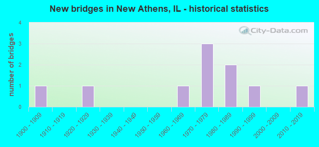
- New bridges - historical statistics
- 11900-1909
- 11920-1929
- 11960-1969
- 31970-1979
- 21980-1989
- 11990-1999
- 12010-2019


- Bridge Condition - Deck
- 14.3%Very good
- 14.3%Good
- 14.3%Satisfactory
- 57.1%Fair

- Bridge Condition - Superstructure
- 12.5%Very good
- 25.0%Good
- 25.0%Satisfactory
- 12.5%Fair
- 12.5%Poor
- 12.5%Serious

- Bridge Condition - Substructure
- 12.5%Very good
- 50.0%Good
- 25.0%Satisfactory
- 12.5%Fair

- Bridge Condition - Channel
- 12.5%Excellent
- 12.5%Very good
- 25.0%Good
- 25.0%Satisfactory
- 12.5%Fair
- 12.5%Poor
Find on map >> Show street view
Structure Number: 820198, Location: W OF NEW ATHENS (Lat: 38.320006, Lng: -89.888844), Route carried "on" structure: State highway 13, Year Built: 1972, Status: Open, Structure Length: 17.55m (57.58ft), Average Daily Traffic: 7,450 (year 2021), Truck Traffic: 11%, Average Future Daily Traffic: 9,153 (year 2032), Design Load: HS 20, Features Intersected: KASKASKIA RIVER
Minimum Vertical Clearance: 30+ m (98+ ft), Kilometerpoint: 38.414, Lanes on structure: 2, Base Highway Network: Yes, Owner: State Highway Agency, Approaching Roadway Width: 13.4m (44.0ft), Navigation Control: Yes ( Vertical Clearance: 15.5m (50.9ft), Horizontal Clearance: 68.6m (225.1ft)), Material/Design: Steel continuous, Design/Construction: Girder and Floorbeam System, Number Of Spans In Main Unit: 3, Length of Maximum Span: 72.5m (237.9ft), Curb-To-Curb Width: 11.9m (39.0ft), Out-to-Out Width: 13.0m (42.7ft)
Condition: Deck: Fair, Superstructure: Satisfactory, Substructure: Good, Channel: Good, Operating Rating: 54.8 metric tons, Method Used To Determine Operating Rating: Load Factor (LF) rating reported by rating factor (RF) method using MS18 loading, Inventory Rating: 29.8 metric tons, Method Used To Determine Inventory Rating: Load Factor (LF) rating reported by rating factor (RF) method using MS18 loading, Structural Evaluation: Equal to present minimum criteria, Deck Geometry: Somewhat better than minimum adequacy, Waterway Adequacy: Superior to present desirable criteria, Approach Roadway Alignment: Equal to present minimum criteria, Designated Inspection Frequency: Every 24 months, Critical Feature Inspection Frequency: Every 24 months, Underwater Inspection Frequency: Every 60 months, Inspection Date: Febuary 2022, Critical Feature Inspection Date: Febuary 2022, Underwater Inspection Date: October 2019, Deck Structure Type: Concrete Cast-file-Place, Wearing Surface/Protective System: Wearing Surface: Bituminous, Membrane: Built-up
Find on map >> Show street view
Structure Number: 820199, Location: 1.5 M SE NEW ATHENS (Lat: 38.304797, Lng: -89.845289), Route carried "on" structure: State highway 13, Year Built: 1971, Year Reconstructed: 1999, Status: Open, Structure Length: 11.55m (37.89ft), Average Daily Traffic: 3,700 (year 2021), Truck Traffic: 10%, Average Future Daily Traffic: 4,289 (year 2032), Design Load: HS 20, Features Intersected: ICG RR
Minimum Vertical Clearance: 30+ m (98+ ft), Kilometerpoint: 42.598, Lanes on structure: 2, Base Highway Network: Yes, Owner: State Highway Agency, Approaching Roadway Width: 13.4m (44.0ft), Skew: 6 degrees, Material/Design: Steel continuous, Design/Construction: Stringer/Multi-beam, Number Of Spans In Main Unit: 3, Number Of Approach Spans: 2, Length of Maximum Span: 44.3m (145.3ft), Curb-To-Curb Width: 11.9m (39.0ft), Out-to-Out Width: 13.0m (42.7ft)
Condition: Deck: Satisfactory, Superstructure: Good, Substructure: Good, Operating Rating: 51.8 metric tons, Method Used To Determine Operating Rating: Load Factor (LF) rating reported by rating factor (RF) method using MS18 loading, Inventory Rating: 30.8 metric tons, Method Used To Determine Inventory Rating: Load Factor (LF) rating reported by rating factor (RF) method using MS18 loading, Structural Evaluation: Better than present minimum criteria, Deck Geometry: Somewhat better than minimum adequacy, Underclear: Equal to present desirable criteria, Approach Roadway Alignment: Equal to present minimum criteria, Designated Inspection Frequency: Every 24 months, Inspection Date: October 2020, Deck Structure Type: Concrete Cast-file-Place, Wearing Surface/Protective System: Wearing Surface: Other
Find on map >> Show street view
Structure Number: 822036, Location: 2.2M N NEW ATHENS (Lat: 38.337939, Lng: -89.908561), Route carried "on" structure: State highway 13, Year Built: 1996, Status: Open, Structure Length: 0.81m (2.66ft), Average Daily Traffic: 5,850 (year 2021), Truck Traffic: 6%, Average Future Daily Traffic: 7,008 (year 2032), Features Intersected: TRIB TO KASKASKIA RV
Minimum Vertical Clearance: 30+ m (98+ ft), Kilometerpoint: 35.517, Lanes on structure: 2, Base Highway Network: Yes, Owner: State Highway Agency, Approaching Roadway Width: 11.6m (38.1ft), Material/Design: Concrete continuous, Design/Construction: Culvert, Number Of Spans In Main Unit: 2, Length of Maximum Span: 3.7m (12.1ft)
Condition: Channel: Satisfactory, Culverts: Very good, Operating Rating: 59.0 metric tons, Method Used To Determine Operating Rating: Load Factor (LF) rating reported by rating factor (RF) method using MS18 loading, Inventory Rating: 35.3 metric tons, Method Used To Determine Inventory Rating: Load Factor (LF) rating reported by rating factor (RF) method using MS18 loading, Structural Evaluation: Equal to present desirable criteria, Waterway Adequacy: Superior to present desirable criteria, Approach Roadway Alignment: Equal to present desirable criteria, Designated Inspection Frequency: Every 48 months, Inspection Date: October 2020
Find on map >> Show street view
Structure Number: 823043, Location: 0.30 MI S IL 13 (Lat: 38.311944, Lng: -89.866136), Route carried "on" structure: City street , Year Built: 1901, Status: Open, Structure Length: 0.79m (2.59ft), Average Daily Traffic: 600 (year 2018), Truck Traffic: 5%, Average Future Daily Traffic: 288 (year 2032), Design Load: H 15, Features Intersected: LIVELY CREEK, Facility Carried by Structure: OLD BALDWIN RD
Minimum Vertical Clearance: 30+ m (98+ ft), Kilometerpoint: 0.885, Lanes on structure: 2, Owner: City or Municipal Highway Agency, Approaching Roadway Width: 10.4m (34.1ft), Material/Design: Concrete, Design/Construction: Slab, Number Of Spans In Main Unit: 1, Length of Maximum Span: 7.6m (24.9ft), Curb-To-Curb Width: 9.8m (32.2ft), Out-to-Out Width: 10.8m (35.4ft)
Condition: Deck: Good, Superstructure: Satisfactory, Substructure: Good, Channel: Good, Operating Rating: 32.4 metric tons, Method Used To Determine Operating Rating: Field evaluation and documented engineering judgment, Inventory Rating: 17.5 metric tons, Method Used To Determine Inventory Rating: Field evaluation and documented engineering judgment, Structural Evaluation: Meets minimum limits, Deck Geometry: Equal to present minimum criteria, Waterway Adequacy: Equal to present desirable criteria, Approach Roadway Alignment: Equal to present desirable criteria, Designated Inspection Frequency: Every 24 months, Inspection Date: June 2020, Deck Structure Type: Concrete Cast-file-Place, Wearing Surface/Protective System: Wearing Surface: Gravel
Find on map >> Show street view
Structure Number: 823077, Location: 4 MI SSE FREEBURG (Lat: 38.365564, Lng: -89.882039), Route carried "on" structure: County highway , Year Built: 1987, Status: Open, Structure Length: 3.72m (12.20ft), Average Daily Traffic: 200 (year 2018), Truck Traffic: 13%, Average Future Daily Traffic: 262 (year 2032), Design Load: HS 20, Features Intersected: SILVER CR, Facility Carried by Structure: FIVE FORKSE.RD/CH
Minimum Vertical Clearance: 30+ m (98+ ft), Kilometerpoint: 2.333, Lanes on structure: 2, Owner: County Highway Agency, Approaching Roadway Width: 9.1m (29.9ft), Material/Design: Concrete, Design/Construction: Channel Beam, Number Of Spans In Main Unit: 3, Length of Maximum Span: 12.2m (40.0ft), Curb-To-Curb Width: 9.1m (29.9ft), Out-to-Out Width: 9.1m (29.9ft)
Condition: Deck: Fair, Superstructure: Poor, Substructure: Satisfactory, Channel: Excellent, Operating Rating: 46.7 metric tons, Method Used To Determine Operating Rating: Load Factor (LF) rating reported by rating factor (RF) method using MS18 loading, Inventory Rating: 27.9 metric tons, Method Used To Determine Inventory Rating: Load Factor (LF) rating reported by rating factor (RF) method using MS18 loading, Structural Evaluation: Meets minimum limits, Deck Geometry: Equal to present minimum criteria, Waterway Adequacy: Superior to present desirable criteria, Approach Roadway Alignment: Equal to present desirable criteria, Designated Inspection Frequency: Every 24 months, Inspection Date: April 2020, Deck Structure Type: Concrete Precast Panels
Find on map >> Show street view
Structure Number: 823078, Location: 4 M SSE FREEBURG (Lat: 38.365575, Lng: -89.878856), Route carried "on" structure: County highway , Year Built: 1987, Status: Open, Structure Length: 12.10m (39.70ft), Average Daily Traffic: 200 (year 2018), Truck Traffic: 13%, Average Future Daily Traffic: 262 (year 2032), Design Load: HS 20, Features Intersected: SILVER CR, Facility Carried by Structure: FIVE FORKSE.RD/CH
Minimum Vertical Clearance: 30+ m (98+ ft), Kilometerpoint: 2.607, Lanes on structure: 2, Owner: County Highway Agency, Approaching Roadway Width: 9.1m (29.9ft), Material/Design: Prestressed concrete, Design/Construction: Box Beam or Girders - Multiple, Number Of Spans In Main Unit: 7, Length of Maximum Span: 18.3m (60.0ft), Curb-To-Curb Width: 9.1m (29.9ft), Out-to-Out Width: 9.1m (29.9ft)
Condition: Deck: Fair, Superstructure: Fair, Substructure: Satisfactory, Channel: Fair, Operating Rating: 44.4 metric tons, Method Used To Determine Operating Rating: Assigned rating based on Load Factor Design (LFD) reported by rating factor (RF) using MS18 loading, Inventory Rating: 32.4 metric tons, Method Used To Determine Inventory Rating: Assigned rating based on Load Factor Design (LFD) reported by rating factor (RF) using MS18 loading, Structural Evaluation: Somewhat better than minimum adequacy, Deck Geometry: Equal to present minimum criteria, Waterway Adequacy: Superior to present desirable criteria, Approach Roadway Alignment: Equal to present desirable criteria, Designated Inspection Frequency: Every 24 months, Inspection Date: April 2020, Deck Structure Type: Concrete Precast Panels, Wearing Surface/Protective System: Wearing Surface: Bituminous, Membrane: Built-up, Deck Protection: Other
Find on map >> Show street view
Structure Number: 824076, Location: 1.0 MI N ILL 13 (Lat: 38.342056, Lng: -89.880161), Route carried "on" structure: County highway , Year Built: 1961, Status: Open, Structure Length: 4.63m (15.19ft), Average Daily Traffic: 75 (year 2018), Truck Traffic: 11%, Average Future Daily Traffic: 157 (year 2032), Design Load: HS 15, Features Intersected: SILVER CR, Facility Carried by Structure: BLACK QUARTER TR 1
Minimum Vertical Clearance: 30+ m (98+ ft), Kilometerpoint: 3.669, Lanes on structure: 2, Owner: Town or Township Highway Agency, Approaching Roadway Width: 7.9m (25.9ft), Material/Design: Concrete, Design/Construction: Channel Beam, Number Of Spans In Main Unit: 5, Length of Maximum Span: 9.1m (29.9ft), Curb-To-Curb Width: 7.3m (24.0ft), Out-to-Out Width: 8.0m (26.2ft)
Condition: Deck: Fair, Superstructure: Serious, Substructure: Fair, Channel: Poor, Operating Rating: 54.4 metric tons, Method Used To Determine Operating Rating: Load Factor (LF) rating reported by rating factor (RF) method using MS18 loading, Inventory Rating: 20.7 metric tons, Method Used To Determine Inventory Rating: Load Factor (LF) rating reported by rating factor (RF) method using MS18 loading, Structural Evaluation: High priority of corrective action, Deck Geometry: Equal to present minimum criteria, Waterway Adequacy: Equal to present minimum criteria, Approach Roadway Alignment: Better than present minimum criteria, Designated Inspection Frequency: Every 24 months, Underwater Inspection Frequency: Every 60 months, Inspection Date: March 2021, Underwater Inspection Date: September 2020, Deck Structure Type: Concrete Precast Panels, Wearing Surface/Protective System: Wearing Surface: Gravel
Find on map >> Show street view
Structure Number: 824096, Location: 1 M S ILL 156 (Lat: 38.305903, Lng: -89.880589), Route carried "on" structure: County highway , Year Built: 1977, Status: Open, Structure Length: 3.05m (10.01ft), Average Daily Traffic: 425 (year 2018), Truck Traffic: 13%, Average Future Daily Traffic: 471 (year 2032), Design Load: HS 20, Features Intersected: LIVELY BRANCH, Facility Carried by Structure: KEIM BRIDGE/ TR 20
Minimum Vertical Clearance: 30+ m (98+ ft), Kilometerpoint: 0.274, Lanes on structure: 2, Owner: Town or Township Highway Agency, Approaching Roadway Width: 9.1m (29.9ft), Material/Design: Concrete, Design/Construction: Channel Beam, Number Of Spans In Main Unit: 3, Length of Maximum Span: 11.6m (38.1ft), Curb-To-Curb Width: 8.5m (27.9ft), Out-to-Out Width: 9.2m (30.2ft)
Condition: Deck: Very good, Superstructure: Good, Substructure: Good, Channel: Satisfactory, Operating Rating: 44.4 metric tons, Method Used To Determine Operating Rating: Assigned rating based on Load Factor Design (LFD) reported by rating factor (RF) using MS18 loading, Inventory Rating: 32.4 metric tons, Method Used To Determine Inventory Rating: Assigned rating based on Load Factor Design (LFD) reported by rating factor (RF) using MS18 loading, Structural Evaluation: Better than present minimum criteria, Deck Geometry: Somewhat better than minimum adequacy, Waterway Adequacy: Better than present minimum criteria, Approach Roadway Alignment: Equal to present desirable criteria, Designated Inspection Frequency: Every 48 months, Inspection Date: Febuary 2019, Deck Structure Type: Concrete Precast Panels
Find on map >> Show street view
Structure Number: 824155, Location: .5MI NE IL 13 (Lat: 38.347639, Lng: -89.875550), Route carried "on" structure: County highway , Year Built: 2010, Status: Open, Structure Length: 1.18m (3.87ft), Average Daily Traffic: 75 (year 2018), Truck Traffic: 11%, Average Future Daily Traffic: 157 (year 2032), Design Load: HS 20, Features Intersected: DRY LANE SLOUGH, Facility Carried by Structure: BLACK QUARTER RD
Minimum Vertical Clearance: 30+ m (98+ ft), Kilometerpoint: 2.881, Lanes on structure: 2, Owner: Town or Township Highway Agency, Approaching Roadway Width: 5.5m (18.0ft), Material/Design: Concrete, Design/Construction: Frame, Number Of Spans In Main Unit: 1, Length of Maximum Span: 11.4m (37.4ft), Curb-To-Curb Width: 8.3m (27.2ft), Out-to-Out Width: 8.3m (27.2ft)
Condition: Superstructure: Very good, Substructure: Very good, Channel: Very good, Operating Rating: 44.1 metric tons, Method Used To Determine Operating Rating: Assigned rating based on Load Factor Design (LFD) reported by rating factor (RF) using MS18 loading, Inventory Rating: 32.4 metric tons, Method Used To Determine Inventory Rating: Assigned rating based on Load Factor Design (LFD) reported by rating factor (RF) using MS18 loading, Structural Evaluation: Equal to present desirable criteria, Deck Geometry: Equal to present minimum criteria, Waterway Adequacy: Meets minimum limits, Approach Roadway Alignment: Better than present minimum criteria, Designated Inspection Frequency: Every 48 months, Inspection Date: April 2021
Find on map >> Show street view
Structure Number: 829914, Location: NEW ATHENS (Lat: 38.315936, Lng: -89.861792), Route carried "under" structure: County highway , Year Built: 1928, Structure Length: 0. m, Average Daily Traffic: 1,400 (year 2018), Truck Traffic: 11%, Features Intersected: FAS 848, Facility Carried by Structure: I.C.& GULF R.R.
Minimum Vertical Clearance: 4.19m (13.75ft), Kilometerpoint: 1.062, Lanes under structure: 2, Material/Design: Steel, Design/Construction: Girder and Floorbeam System, Length of Maximum Span: 13.4m (44.0ft)