Bridge Statistics for Negaunee, Michigan (MI)
Condition, Traffic, Stress, Structural Evaluation, Project Costs
- National Bridge Inventory (NBI) Statistics
- 14Number of bridges
- 154ft / 47.4mTotal length
- $238,000Total costs
- 45,049Total average daily traffic
- 1,654Total average daily truck traffic
- National Bridge Inventory (NBI) Registered Bridges for Negaunee
- No street view available for this location
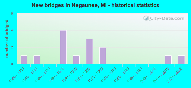
- New bridges - historical statistics
- 11900-1909
- 11910-1919
- 41930-1939
- 11940-1949
- 31950-1959
- 21960-1969
- 12010-2019
- 12020-2022

- Reconstructed bridges - Historical Statistics
- 11990-1999
- 02000-2009
- 12010-2019


- Bridge Condition - Deck
- 10.0%Good
- 50.0%Satisfactory
- 30.0%Fair
- 10.0%Critical

- Bridge Condition - Superstructure
- 30.0%Very good
- 20.0%Good
- 20.0%Satisfactory
- 20.0%Fair
- 10.0%Critical

- Bridge Condition - Substructure
- 30.0%Good
- 50.0%Satisfactory
- 10.0%Fair
- 10.0%Critical

- Bridge Condition - Channel
- 25.0%Very good
- 50.0%Good
- 12.5%Fair
- 12.5%Poor
Find on map >> Show street view
Structure Number: 663, Location: 1.0 MI W OF FISHERVILLE (Lat: 43.597575, Lng: -84.128872), Route carried "on" structure: County highway 2015, Year Built: 1958, Status: Temporarily open, Structure Length: 6.03m (19.78ft), Average Daily Traffic: 900 (year 1997), Truck Traffic: 3%, Average Future Daily Traffic: 160 (year 1977), Design Load: H 15, Features Intersected: US-10, Facility Carried by Structure: CARTER RD
Minimum Vertical Clearance: 30.48m (100.00ft), Kilometerpoint: 3.240, Lanes on structure: 2, Lanes under structure: 4, Owner: State Highway Agency, Approaching Roadway Width: 11.5m (37.7ft), Material/Design: Concrete continuous, Design/Construction: Tee Beam, Number Of Spans In Main Unit: 4, Length of Maximum Span: 17.9m (58.7ft), Curb or Sidewalk Widths: Left: 0.7m (2.3ft), Right: 0.7m (2.3ft), Curb-To-Curb Width: 7.9m (25.9ft), Out-to-Out Width: 10.1m (33.1ft)
Condition: Deck: Fair, Superstructure: Fair, Substructure: Satisfactory, Operating Rating: 51.2 metric tons, Method Used To Determine Operating Rating: Load Factor (LF) rating reported by rating factor (RF) method using MS18 loading, Inventory Rating: 30.8 metric tons, Method Used To Determine Inventory Rating: Load Factor (LF) rating reported by rating factor (RF) method using MS18 loading, Structural Evaluation: Somewhat better than minimum adequacy, Deck Geometry: Somewhat better than minimum adequacy, Underclear: Meets minimum limits, Approach Roadway Alignment: Better than present minimum criteria, Length Of Structure Improvement: 6.04m (19.82ft), Designated Inspection Frequency: Every 22 months, Inspection Date: June 2020, Bridge Improvement Cost: $70,000, Roadway Improvement Cost: $7,000, Total Project Cost: $82,000, Deck Structure Type: Concrete Cast-file-Place, Wearing Surface/Protective System: Wearing Surface: Monolithic Concrete
Find on map >> Show street view
Structure Number: 6492, Location: 7.0 MI NE OF PALMER (Lat: 46.506733, Lng: -87.537508), Route carried "on" structure: State highway 35, Year Built: 2020, Status: Open, Structure Length: 1.46m (4.79ft), Average Daily Traffic: 3,650 (year 2020), Truck Traffic: 9%, Average Future Daily Traffic: 4,225 (year 2040), Design Load: Greater than HL93, Features Intersected: CARP RIVER
Minimum Vertical Clearance: 30.48m (100.00ft), Kilometerpoint: 64.162, Lanes on structure: 2, Base Highway Network: Yes (Inventory Route: 156, Subroute: 8), Owner: State Highway Agency, Approaching Roadway Width: 13.4m (44.0ft), Material/Design: Concrete, Design/Construction: Culvert, Number Of Spans In Main Unit: 1, Length of Maximum Span: 14.6m (47.9ft), Curb-To-Curb Width: 13.4m (44.0ft), Out-to-Out Width: 14.4m (47.2ft)
Condition: Channel: Very good, Culverts: Very good, Operating Rating: 56.1 metric tons, Method Used To Determine Operating Rating: Load and Resistance Factor Rating (LRFR) rating reported by rating factor(RF) method using HL-93 loadings, Inventory Rating: 38.2 metric tons, Method Used To Determine Inventory Rating: Load and Resistance Factor Rating (LRFR) rating reported by rating factor(RF) method using HL-93 loadings, Structural Evaluation: Equal to present desirable criteria, Deck Geometry: Better than present minimum criteria, Waterway Adequacy: Equal to present minimum criteria, Approach Roadway Alignment: Equal to present minimum criteria, Length Of Structure Improvement: 0.40m (1.31ft), Designated Inspection Frequency: Every 24 months, Inspection Date: June 2021, Bridge Improvement Cost: $8,000, Roadway Improvement Cost: $1,000, Total Project Cost: $9,000 ( Estimate for 2050), Wearing Surface/Protective System: Wearing Surface: Low Slump Concrete
Find on map >> Show street view
Structure Number: 6493, Location: 4.0 MI NE OF PALMER (Lat: 46.472667, Lng: -87.540844), Route carried "on" structure: State highway 35, Year Built: 1965, Year Reconstructed: 2001, Status: Open, Structure Length: 7.98m (26.18ft), Average Daily Traffic: 2,505 (year 2007), Truck Traffic: 11%, Average Future Daily Traffic: 2,565 (year 2018), Design Load: HS 25 or greater, Features Intersected: C&NW & GOOSE LAKE
Minimum Vertical Clearance: 30.48m (100.00ft), Kilometerpoint: 59.079, Lanes on structure: 2, Base Highway Network: Yes (Inventory Route: 156, Subroute: 8), Owner: State Highway Agency, Approaching Roadway Width: 11.6m (38.1ft), Skew: 3 degrees, Material/Design: Prestressed concrete, Design/Construction: Stringer/Multi-beam, Number Of Spans In Main Unit: 4, Length of Maximum Span: 22.8m (74.8ft), Curb or Sidewalk Widths: Left: 0.6m (2.0ft), Right: 0.6m (2.0ft), Curb-To-Curb Width: 13.4m (44.0ft), Out-to-Out Width: 14.2m (46.6ft)
Condition: Deck: Good, Superstructure: Very good, Substructure: Good, Channel: Good, Operating Rating: 74.8 metric tons, Method Used To Determine Operating Rating: Load Factor (LF) rating reported by rating factor (RF) method using MS18 loading, Inventory Rating: 45.7 metric tons, Method Used To Determine Inventory Rating: Load Factor (LF) rating reported by rating factor (RF) method using MS18 loading, Structural Evaluation: Better than present minimum criteria, Deck Geometry: Better than present minimum criteria, Underclear: Better than present minimum criteria, Waterway Adequacy: Equal to present minimum criteria, Approach Roadway Alignment: Equal to present minimum criteria, Designated Inspection Frequency: Every 24 months, Inspection Date: June 2021, Deck Structure Type: Concrete Cast-file-Place, Wearing Surface/Protective System: Wearing Surface: Monolithic Concrete
Find on map >> Show street view
Structure Number: 6501, Location: 1.3 MI W OF M-35 (Lat: 46.524483, Lng: -87.573244), Route carried "on" structure: US 41, Year Built: 1955, Status: Open, Structure Length: 3.35m (10.99ft), Average Daily Traffic: 8,662 (year 2007), Truck Traffic: 4%, Average Future Daily Traffic: 10,678 (year 2018), Design Load: HS 20, Features Intersected: CARP RIVER
Minimum Vertical Clearance: 30.48m (100.00ft), Kilometerpoint: 52.394, Lanes on structure: 2, Base Highway Network: Yes (Inventory Route: 156, Subroute: 9), Owner: State Highway Agency, Approaching Roadway Width: 10.4m (34.1ft), Material/Design: Steel, Design/Construction: Stringer/Multi-beam, Number Of Spans In Main Unit: 3, Length of Maximum Span: 12.2m (40.0ft), Curb-To-Curb Width: 12.2m (40.0ft), Out-to-Out Width: 13.2m (43.3ft)
Condition: Deck: Fair, Superstructure: Good, Substructure: Good, Channel: Good, Operating Rating: 60.6 metric tons, Method Used To Determine Operating Rating: Load Factor (LF) rating reported by rating factor (RF) method using MS18 loading, Inventory Rating: 36.3 metric tons, Method Used To Determine Inventory Rating: Load Factor (LF) rating reported by rating factor (RF) method using MS18 loading, Structural Evaluation: Better than present minimum criteria, Deck Geometry: Better than present minimum criteria, Waterway Adequacy: Equal to present minimum criteria, Approach Roadway Alignment: Better than present minimum criteria, Designated Inspection Frequency: Every 24 months, Inspection Date: June 2021, Deck Structure Type: Concrete Cast-file-Place, Wearing Surface/Protective System: Wearing Surface: Integral Concrete, Membrane: Other
Find on map >> Show street view
Structure Number: 6502, Location: 1.3 MI W OF M-35 (Lat: 46.524622, Lng: -87.573300), Route carried "on" structure: US 41, Year Built: 1958, Status: Open, Structure Length: 3.35m (10.99ft), Average Daily Traffic: 8,662 (year 2007), Truck Traffic: 4%, Average Future Daily Traffic: 10,678 (year 2018), Design Load: HS 20, Features Intersected: CARP RIVER
Minimum Vertical Clearance: 30.48m (100.00ft), Kilometerpoint: 3.428, Lanes on structure: 2, Base Highway Network: Yes (Inventory Route: 352, Subroute: 77), Owner: State Highway Agency, Approaching Roadway Width: 10.4m (34.1ft), Material/Design: Steel, Design/Construction: Stringer/Multi-beam, Number Of Spans In Main Unit: 3, Length of Maximum Span: 12.2m (40.0ft), Curb-To-Curb Width: 12.2m (40.0ft), Out-to-Out Width: 13.2m (43.3ft)
Condition: Deck: Fair, Superstructure: Good, Substructure: Satisfactory, Channel: Good, Operating Rating: 59.0 metric tons, Method Used To Determine Operating Rating: Load Factor (LF) rating reported by rating factor (RF) method using MS18 loading, Inventory Rating: 35.3 metric tons, Method Used To Determine Inventory Rating: Load Factor (LF) rating reported by rating factor (RF) method using MS18 loading, Structural Evaluation: Equal to present minimum criteria, Deck Geometry: Better than present minimum criteria, Waterway Adequacy: Equal to present minimum criteria, Approach Roadway Alignment: Better than present minimum criteria, Designated Inspection Frequency: Every 24 months, Inspection Date: June 2021, Bridge Improvement Cost: $18,000, Deck Structure Type: Concrete Cast-file-Place, Wearing Surface/Protective System: Wearing Surface: Latex Concrete, Membrane: Other
Find on map >> Show street view
Structure Number: 6522, Location: IN NEGAUNEE (Lat: 46.497900, Lng: -87.611847), Route carried "on" structure: City street , Year Built: 1936, Status: Open, Structure Length: 2.23m (7.32ft), Average Daily Traffic: 120 (year 2010), Average Future Daily Traffic: 137 (year 2030), Design Load: Railroad, Features Intersected: M-28 BR SILVER ST, Facility Carried by Structure: RAIL STREET
Minimum Vertical Clearance: 30.48m (100.00ft), Kilometerpoint: 0.089, Lanes on structure: 2, Lanes under structure: 2, Owner: State Highway Agency, Maintenance Responsibility: City or Municipal Highway Agency, Approaching Roadway Width: 8.5m (27.9ft), Skew: 1 degrees, Material/Design: Steel, Design/Construction: Stringer/Multi-beam, Number Of Spans In Main Unit: 1, Number Of Approach Spans: 2, Length of Maximum Span: 13.3m (43.6ft), Curb-To-Curb Width: 8.5m (27.9ft), Out-to-Out Width: 39.9m (130.9ft)
Condition: Deck: Satisfactory, Superstructure: Satisfactory, Substructure: Satisfactory, Inventory Rating: 62.3 metric tons, Method Used To Determine Inventory Rating: Load Factor (LF), Structural Evaluation: Equal to present minimum criteria, Deck Geometry: Equal to present minimum criteria, Underclear: Meets minimum limits, Approach Roadway Alignment: Equal to present desirable criteria, Designated Inspection Frequency: Every 24 months, Inspection Date: June 2021, Wearing Surface/Protective System: Wearing Surface: Monolithic Concrete
Find on map >> Show street view
Structure Number: 6545, Location: IN NEGAUNEE (Lat: 46.502550, Lng: -87.566719), Route carried "on" structure: County highway 5278, Year Built: 1968, Year Reconstructed: 2015, Status: Posted for load, Structure Length: 2.90m (9.51ft), Average Daily Traffic: 4,000 (year 2015), Average Future Daily Traffic: 4,400 (year 2035), Design Load: HS 20+Mod, Features Intersected: L S & I RAILROAD, Facility Carried by Structure: COUNTY RD 480
Minimum Vertical Clearance: 30.48m (100.00ft), Kilometerpoint: 1.730, Lanes on structure: 2, Owner: County Highway Agency, Approaching Roadway Width: 13.4m (44.0ft), Skew: 6 degrees, Material/Design: Steel, Design/Construction: Stringer/Multi-beam, Number Of Spans In Main Unit: 1, Length of Maximum Span: 28.4m (93.2ft), Curb-To-Curb Width: 13.4m (44.0ft), Out-to-Out Width: 14.3m (46.9ft)
Condition: Deck: Satisfactory, Superstructure: Very good, Substructure: Fair, Operating Rating: 26.2 metric tons, Method Used To Determine Operating Rating: Load Factor (LF) rating reported by rating factor (RF) method using MS18 loading, Inventory Rating: 15.9 metric tons, Method Used To Determine Inventory Rating: Load Factor (LF) rating reported by rating factor (RF) method using MS18 loading, Structural Evaluation: Meets minimum limits, Deck Geometry: Better than present minimum criteria, Approach Roadway Alignment: Equal to present desirable criteria, Bridge Posting: Required (Relationship of Operating Rating to Maximum Legal Load: > 39.9% below), Designated Inspection Frequency: Every 24 months, Inspection Date: October 2021, Deck Structure Type: Concrete Cast-file-Place, Wearing Surface/Protective System: Wearing Surface: Monolithic Concrete, Deck Protection: Epoxy Coated Reinforcing
Find on map >> Show street view
Structure Number: 6596, Location: 0.02 MI N OF US-41 (Lat: 46.524178, Lng: -87.575936), Route carried "on" structure: County highway , Year Built: 1946, Status: Temporarily open, Structure Length: 1.49m (4.89ft), Average Daily Traffic: 100 (year 1994), Average Future Daily Traffic: 100 (year 2020), Design Load: HS 20+Mod, Features Intersected: CARP RIVER, Facility Carried by Structure: JAD ROAD (OLD M41)
Minimum Vertical Clearance: 30.48m (100.00ft), Kilometerpoint: 1.357, Lanes on structure: 2, Owner: County Highway Agency, Approaching Roadway Width: 9.8m (32.2ft), Material/Design: Wood or Timber, Design/Construction: Slab, Number Of Spans In Main Unit: 3, Length of Maximum Span: 5.1m (16.7ft), Curb or Sidewalk Widths: Left: 0.4m (1.3ft), Right: 0.4m (1.3ft), Curb-To-Curb Width: 12.2m (40.0ft), Out-to-Out Width: 13.2m (43.3ft)
Condition: Deck: Critical, Superstructure: Critical, Substructure: Critical, Channel: Poor, Structural Evaluation: High priority of replacement, Deck Geometry: Superior to present desirable criteria, Waterway Adequacy: Better than present minimum criteria, Approach Roadway Alignment: Better than present minimum criteria, Bridge Posting: Required (Relationship of Operating Rating to Maximum Legal Load: > 39.9% below), Designated Inspection Frequency: Every 12 months, Inspection Date: July 2021, Bridge Improvement Cost: $42,000, Roadway Improvement Cost: $4,000, Total Project Cost: $49,000, Deck Structure Type: Other, Wearing Surface/Protective System: Wearing Surface: Monolithic Concrete
Find on map >> Show street view
Structure Number: 6597, Location: 1.5 MI N OF US41 (Lat: 46.530364, Lng: -87.603933), Route carried "on" structure: County highway , Year Built: 1934, Status: Open, Structure Length: 1.12m (3.67ft), Average Daily Traffic: 1,004 (year 2001), Average Future Daily Traffic: 1,025 (year 2020), Design Load: HS 20+Mod, Features Intersected: CARP RIVER, Facility Carried by Structure: JA ROAD
Minimum Vertical Clearance: 30.48m (100.00ft), Kilometerpoint: 2.054, Lanes on structure: 2, Owner: County Highway Agency, Approaching Roadway Width: 7.3m (24.0ft), Material/Design: Steel, Design/Construction: Stringer/Multi-beam, Number Of Spans In Main Unit: 1, Length of Maximum Span: 10.6m (34.8ft), Curb-To-Curb Width: 6.0m (19.7ft), Out-to-Out Width: 6.6m (21.7ft)
Condition: Deck: Satisfactory, Superstructure: Satisfactory, Substructure: Satisfactory, Channel: Fair, Operating Rating: 77.3 metric tons, Method Used To Determine Operating Rating: Load Factor (LF), Inventory Rating: 36.4 metric tons, Method Used To Determine Inventory Rating: Load Factor (LF), Structural Evaluation: Equal to present minimum criteria, Deck Geometry: High priority of replacement, Waterway Adequacy: Equal to present desirable criteria, Approach Roadway Alignment: Better than present minimum criteria, Length Of Structure Improvement: 1.13m (3.71ft), Designated Inspection Frequency: Every 24 months, Inspection Date: October 2021, Bridge Improvement Cost: $58,000, Roadway Improvement Cost: $6,000, Total Project Cost: $68,000 ( Estimate for 2050), Deck Structure Type: Concrete Cast-file-Place, Wearing Surface/Protective System: Wearing Surface: Monolithic Concrete
Find on map >> Show street view
Structure Number: 663, Location: 02 MI E OF US-41 OR M-28 (Lat: 46.518533, Lng: -87.560992), Route carried "on" structure: City street , Year Built: 1932, Status: Posted for load, Structure Length: 1.22m (4.00ft), Average Daily Traffic: 900 (year 2001), Average Future Daily Traffic: 3,000 (year 2020), Design Load: HS 20+Mod, Features Intersected: CARP RIVER, Facility Carried by Structure: COUNTY ROAD 492
Minimum Vertical Clearance: 30.48m (100.00ft), Kilometerpoint: 4.054, Lanes on structure: 2, Owner: City or Municipal Highway Agency, Approaching Roadway Width: 9.8m (32.2ft), Material/Design: Steel, Design/Construction: Stringer/Multi-beam, Number Of Spans In Main Unit: 1, Length of Maximum Span: 11.5m (37.7ft), Curb-To-Curb Width: 9.1m (29.9ft), Out-to-Out Width: 10.0m (32.8ft)
Condition: Deck: Satisfactory, Superstructure: Fair, Substructure: Satisfactory, Channel: Good, Operating Rating: 37.3 metric tons, Method Used To Determine Operating Rating: Load Factor (LF) rating reported by rating factor (RF) method using MS18 loading, Inventory Rating: 22.4 metric tons, Method Used To Determine Inventory Rating: Load Factor (LF) rating reported by rating factor (RF) method using MS18 loading, Structural Evaluation: Somewhat better than minimum adequacy, Deck Geometry: Equal to present minimum criteria, Waterway Adequacy: Equal to present desirable criteria, Approach Roadway Alignment: Equal to present desirable criteria, Bridge Posting: Required (Relationship of Operating Rating to Maximum Legal Load: 20.0 - 29.9% below), Length Of Structure Improvement: 1.74m (5.71ft), Designated Inspection Frequency: Every 24 months, Inspection Date: October 2021, Bridge Improvement Cost: $30,000, Total Project Cost: $30,000, Deck Structure Type: Concrete Cast-file-Place, Wearing Surface/Protective System: Wearing Surface: Bituminous
Find on map >> Show street view
Structure Number: 1351, Location: 2 MILES N OF US-41 (Lat: 46.558194, Lng: -87.545944), Route carried "on" structure: County highway 5290, Year Built: 2010, Status: Open, Structure Length: 16.22m (53.22ft), Average Daily Traffic: 1,912 (year 2017), Truck Traffic: 9%, Average Future Daily Traffic: 1,950 (year 2037), Features Intersected: DEAD RIVER, Facility Carried by Structure: CO RD 510(RELOC)
Minimum Vertical Clearance: 30.48m (100.00ft), Kilometerpoint: 0.295, Lanes on structure: 2, Owner: County Highway Agency, Approaching Roadway Width: 10.4m (34.1ft), Material/Design: Steel continuous, Design/Construction: Stringer/Multi-beam, Number Of Spans In Main Unit: 3, Length of Maximum Span: 67.1m (220.1ft), Curb-To-Curb Width: 10.4m (34.1ft), Out-to-Out Width: 11.1m (36.4ft)
Condition: Deck: Satisfactory, Superstructure: Very good, Substructure: Good, Channel: Very good, Operating Rating: 75.8 metric tons, Method Used To Determine Operating Rating: Load and Resistance Factor Rating (LRFR) rating reported by rating factor(RF) method using HL-93 loadings, Inventory Rating: 58.3 metric tons, Method Used To Determine Inventory Rating: Load and Resistance Factor Rating (LRFR) rating reported by rating factor(RF) method using HL-93 loadings, Structural Evaluation: Better than present minimum criteria, Deck Geometry: Equal to present minimum criteria, Waterway Adequacy: Equal to present desirable criteria, Approach Roadway Alignment: Equal to present desirable criteria, Designated Inspection Frequency: Every 24 months, Inspection Date: October 2020, Deck Structure Type: Concrete Cast-file-Place, Wearing Surface/Protective System: Wearing Surface: Monolithic Concrete, Deck Protection: Epoxy Coated Reinforcing
Find on map >> Show street view
Structure Number: 6522, Location: IN NEGAUNEE (Lat: 46.497900, Lng: -87.611847), Route carried "under" structure: Business State highway 28, Year Built: 1936, Structure Length: 0. m, Average Daily Traffic: 1,600 (year 2010), Truck Traffic: 1%, Features Intersected: M-28 BR SILVER ST, Facility Carried by Structure: RAIL STREET
Minimum Vertical Clearance: 4.34m (14.24ft), Kilometerpoint: 9.429, Lanes on structure: 2, Lanes under structure: 2, Material/Design: Steel, Design/Construction: Stringer/Multi-beam, Length of Maximum Span: 13.3m (43.6ft)
Find on map >> Show street view
Structure Number: 6523, Location: IN NEGAUNEE (Lat: 46.506100, Lng: -87.612256), Route carried "under" structure: Business State highway 28, Year Built: 1908, Structure Length: 0. m, Average Daily Traffic: 7,233 (year 2007), Truck Traffic: 2%, Features Intersected: M-28 BR, Facility Carried by Structure: LS&I RR
Minimum Vertical Clearance: 5.08m (16.67ft), Kilometerpoint: 0.761, Lanes under structure: 2, Material/Design: Steel, Design/Construction: Girder and Floorbeam System, Length of Maximum Span: 14.3m (46.9ft)
Find on map >> Show street view
Structure Number: 6546, Location: 1.5 MI E OF BUS M-28 (Lat: 46.501369, Lng: -87.579211), Route carried "under" structure: City street , Year Built: 1910, Structure Length: 0. m, Average Daily Traffic: 3,801 (year 2001), Features Intersected: COUNTY ROAD 480, Facility Carried by Structure: WCL RR
Minimum Vertical Clearance: 5.71m (18.73ft), Kilometerpoint: 1.057, Lanes under structure: 2, Material/Design: Steel, Design/Construction: Girder and Floorbeam System, Length of Maximum Span: 12.8m (42.0ft)