Bridge Statistics for Nashwauk, Minnesota (MN)
Condition, Traffic, Stress, Structural Evaluation, Project Costs
- National Bridge Inventory (NBI) Statistics
- 15Number of bridges
- 446ft / 136mTotal length
- $46,000,000Total costs
- 38,031Total average daily traffic
- 1,998Total average daily truck traffic
- National Bridge Inventory (NBI) Registered Bridges for Nashwauk
- No street view available for this location
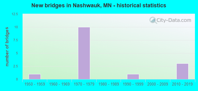
- New bridges - historical statistics
- 11950-1959
- 101970-1979
- 11990-1999
- 32010-2019


- Bridge Condition - Deck
- 20.0%Very good
- 30.0%Good
- 40.0%Satisfactory
- 10.0%Fair

- Bridge Condition - Superstructure
- 20.0%Very good
- 30.0%Good
- 30.0%Satisfactory
- 20.0%Fair

- Bridge Condition - Substructure
- 20.0%Very good
- 30.0%Good
- 40.0%Satisfactory
- 10.0%Fair

- Bridge Condition - Channel
- 50.0%Very good
- 50.0%Fair
Find on map >> Show street view
Structure Number: 31008, Location: .6MI NE OF JCT US 169 (Lat: 47.349994, Lng: -93.194206), Route carried "on" structure: , Year Built: 2015, Status: Open, Structure Length: 33.51m (109.94ft), Features Intersected: US 169;BNSF;MESABI TRAIL, Facility Carried by Structure: UTILITIES
Lanes under structure: 6, Owner: State Highway Agency, Material/Design: Steel, Design/Construction: Truss - Thru, Number Of Spans In Main Unit: 8, Length of Maximum Span: 55.5m (182.1ft), Out-to-Out Width: 3.7m (12.1ft)
Condition: Deck: Very good, Superstructure: Very good, Substructure: Very good, Structural Evaluation: Equal to present desirable criteria, Underclear: High priority of corrective action, Designated Inspection Frequency: Every 24 months, Inspection Date: August 2021, Deck Structure Type: Wood or Timber
Find on map >> Show street view
Structure Number: 31009, Location: 1.1 MI W OF E. CO. LINE (Lat: 47.393856, Lng: -93.091103), Route carried "on" structure: US 169, Year Built: 1971, Status: Open, Structure Length: 4.94m (16.21ft), Average Daily Traffic: 3,650 (year 2019), Truck Traffic: 4%, Average Future Daily Traffic: 3,500 (year 2039), Design Load: HS 20, Features Intersected: BNSF RR SPUR
Minimum Vertical Clearance: 30+ m (98+ ft), Kilometerpoint: 0.000, Lanes on structure: 2, Base Highway Network: Yes, Owner: State Highway Agency, Approaching Roadway Width: 11.3m (37.1ft), Material/Design: Prestressed concrete, Design/Construction: Stringer/Multi-beam, Number Of Spans In Main Unit: 3, Length of Maximum Span: 16.2m (53.1ft), Curb-To-Curb Width: 12.3m (40.4ft), Out-to-Out Width: 13.6m (44.6ft)
Condition: Deck: Satisfactory, Superstructure: Satisfactory, Substructure: Satisfactory, Operating Rating: 67.6 metric tons, Method Used To Determine Operating Rating: Load Factor (LF), Inventory Rating: 30.0 metric tons, Method Used To Determine Inventory Rating: Load Factor (LF), Structural Evaluation: Equal to present minimum criteria, Deck Geometry: Better than present minimum criteria, Underclear: Superior to present desirable criteria, Approach Roadway Alignment: Better than present minimum criteria, Designated Inspection Frequency: Every 24 months, Inspection Date: September 2020, Deck Structure Type: Concrete Cast-file-Place, Wearing Surface/Protective System: Wearing Surface: Low Slump Concrete
Find on map >> Show street view
Structure Number: 3101, Location: 1.1 MI W OF E. CO. LINE (Lat: 47.393506, Lng: -93.091033), Route carried "on" structure: US 169, Year Built: 1971, Status: Open, Structure Length: 4.94m (16.21ft), Average Daily Traffic: 3,650 (year 2019), Truck Traffic: 5%, Average Future Daily Traffic: 3,500 (year 2039), Design Load: HS 20, Features Intersected: BNSF RR SPUR
Minimum Vertical Clearance: 30+ m (98+ ft), Kilometerpoint: 0.000, Lanes on structure: 2, Base Highway Network: Yes, Owner: State Highway Agency, Approaching Roadway Width: 11.3m (37.1ft), Material/Design: Prestressed concrete, Design/Construction: Stringer/Multi-beam, Number Of Spans In Main Unit: 3, Length of Maximum Span: 16.2m (53.1ft), Curb-To-Curb Width: 12.3m (40.4ft), Out-to-Out Width: 13.6m (44.6ft)
Condition: Deck: Satisfactory, Superstructure: Good, Substructure: Good, Operating Rating: 68.1 metric tons, Method Used To Determine Operating Rating: Load Factor (LF), Inventory Rating: 29.0 metric tons, Method Used To Determine Inventory Rating: Load Factor (LF), Structural Evaluation: Better than present minimum criteria, Deck Geometry: Better than present minimum criteria, Underclear: Superior to present desirable criteria, Approach Roadway Alignment: Better than present minimum criteria, Designated Inspection Frequency: Every 24 months, Inspection Date: September 2020, Deck Structure Type: Concrete Cast-file-Place, Wearing Surface/Protective System: Wearing Surface: Low Slump Concrete
Find on map >> Show street view
Structure Number: 31019, Location: 1.8 MI W OF JCT CSAH 16 (Lat: 47.387947, Lng: -93.106308), Route carried "on" structure: US 169, Year Built: 1976, Status: Open, Structure Length: 7.61m (24.97ft), Average Daily Traffic: 3,650 (year 2019), Truck Traffic: 4%, Average Future Daily Traffic: 3,500 (year 2039), Design Load: HS 20, Features Intersected: TRAIL
Minimum Vertical Clearance: 30+ m (98+ ft), Kilometerpoint: 0.000, Lanes on structure: 2, Base Highway Network: Yes, Owner: State Highway Agency, Approaching Roadway Width: 11.3m (37.1ft), Skew: 3 degrees, Material/Design: Prestressed concrete, Design/Construction: Stringer/Multi-beam, Number Of Spans In Main Unit: 4, Length of Maximum Span: 23.4m (76.8ft), Curb-To-Curb Width: 12.3m (40.4ft), Out-to-Out Width: 13.5m (44.3ft)
Condition: Deck: Satisfactory, Superstructure: Satisfactory, Substructure: Fair, Operating Rating: 65.7 metric tons, Method Used To Determine Operating Rating: Load Factor (LF), Inventory Rating: 34.1 metric tons, Method Used To Determine Inventory Rating: Load Factor (LF), Structural Evaluation: Somewhat better than minimum adequacy, Deck Geometry: Better than present minimum criteria, Approach Roadway Alignment: Better than present minimum criteria, Designated Inspection Frequency: Every 24 months, Inspection Date: May 2021, Deck Structure Type: Concrete Cast-file-Place, Wearing Surface/Protective System: Wearing Surface: Low Slump Concrete
Find on map >> Show street view
Structure Number: 3102, Location: 1.8 MI W OF JCT CSAH 16 (Lat: 47.387547, Lng: -93.106172), Route carried "on" structure: US 169, Year Built: 1976, Status: Open, Structure Length: 7.87m (25.82ft), Average Daily Traffic: 3,650 (year 2019), Truck Traffic: 5%, Average Future Daily Traffic: 3,500 (year 2039), Design Load: HS 20, Features Intersected: MINE RD
Minimum Vertical Clearance: 30+ m (98+ ft), Kilometerpoint: 0.000, Lanes on structure: 2, Base Highway Network: Yes, Owner: State Highway Agency, Approaching Roadway Width: 11.3m (37.1ft), Skew: 3 degrees, Material/Design: Prestressed concrete, Design/Construction: Stringer/Multi-beam, Number Of Spans In Main Unit: 4, Length of Maximum Span: 23.5m (77.1ft), Curb-To-Curb Width: 12.3m (40.4ft), Out-to-Out Width: 13.5m (44.3ft)
Condition: Deck: Good, Superstructure: Satisfactory, Substructure: Satisfactory, Operating Rating: 63.9 metric tons, Method Used To Determine Operating Rating: Load Factor (LF), Inventory Rating: 38.2 metric tons, Method Used To Determine Inventory Rating: Load Factor (LF), Structural Evaluation: Equal to present minimum criteria, Deck Geometry: Better than present minimum criteria, Approach Roadway Alignment: Equal to present desirable criteria, Designated Inspection Frequency: Every 12 months, Inspection Date: June 2021, Deck Structure Type: Concrete Cast-file-Place, Wearing Surface/Protective System: Wearing Surface: Low Slump Concrete
Find on map >> Show street view
Structure Number: 31022N, Location: 0.3 MI E OF JCT TH 65 (Lat: 47.370956, Lng: -93.166442), Route carried "on" structure: US 169, Year Built: 1976, Status: Open, Structure Length: 27.39m (89.86ft), Average Daily Traffic: 2,850 (year 2019), Truck Traffic: 5%, Average Future Daily Traffic: 3,000 (year 2039), Design Load: HS 20, Features Intersected: ST
Minimum Vertical Clearance: 30+ m (98+ ft), Kilometerpoint: 0.000, Lanes on structure: 2, Lanes under structure: 2, Base Highway Network: Yes, Owner: State Highway Agency, Approaching Roadway Width: 11.3m (37.1ft), Material/Design: Prestressed concrete, Design/Construction: Stringer/Multi-beam, Number Of Spans In Main Unit: 9, Length of Maximum Span: 33.3m (109.3ft), Curb-To-Curb Width: 12.3m (40.4ft), Out-to-Out Width: 13.5m (44.3ft)
Condition: Deck: Satisfactory, Superstructure: Fair, Substructure: Satisfactory, Operating Rating: 72.5 metric tons, Method Used To Determine Operating Rating: Load Factor (LF), Inventory Rating: 29.0 metric tons, Method Used To Determine Inventory Rating: Load Factor (LF), Structural Evaluation: Somewhat better than minimum adequacy, Deck Geometry: Better than present minimum criteria, Underclear: Somewhat better than minimum adequacy, Approach Roadway Alignment: Equal to present desirable criteria, Designated Inspection Frequency: Every 24 months, Inspection Date: May 2021, Deck Structure Type: Concrete Cast-file-Place, Wearing Surface/Protective System: Wearing Surface: Low Slump Concrete
Find on map >> Show street view
Structure Number: 31022S, Location: 0.3 MI E OF JCT TH 65 (Lat: 47.371075, Lng: -93.166558), Route carried "on" structure: US 169, Year Built: 1976, Status: Open, Structure Length: 30.53m (100.16ft), Average Daily Traffic: 3,000 (year 2017), Truck Traffic: 4%, Average Future Daily Traffic: 3,000 (year 2039), Design Load: HS 20, Features Intersected: ST
Minimum Vertical Clearance: 30+ m (98+ ft), Kilometerpoint: 0.000, Lanes on structure: 2, Lanes under structure: 2, Base Highway Network: Yes, Owner: State Highway Agency, Approaching Roadway Width: 11.3m (37.1ft), Material/Design: Prestressed concrete, Design/Construction: Stringer/Multi-beam, Number Of Spans In Main Unit: 10, Length of Maximum Span: 33.3m (109.3ft), Curb-To-Curb Width: 12.3m (40.4ft), Out-to-Out Width: 13.5m (44.3ft)
Condition: Deck: Fair, Superstructure: Fair, Substructure: Satisfactory, Operating Rating: 72.5 metric tons, Method Used To Determine Operating Rating: Load Factor (LF), Inventory Rating: 28.4 metric tons, Method Used To Determine Inventory Rating: Load Factor (LF), Structural Evaluation: Somewhat better than minimum adequacy, Deck Geometry: Better than present minimum criteria, Underclear: Somewhat better than minimum adequacy, Approach Roadway Alignment: Better than present minimum criteria, Designated Inspection Frequency: Every 24 months, Inspection Date: June 2021, Deck Structure Type: Concrete Cast-file-Place, Wearing Surface/Protective System: Wearing Surface: Low Slump Concrete
Find on map >> Show street view
Structure Number: 31023, Location: 0.6 MI SW OF N JCT TH 65 (Lat: 47.362964, Lng: -93.178344), Route carried "on" structure: US 169, Year Built: 1976, Status: Open, Structure Length: 7.39m (24.25ft), Average Daily Traffic: 3,850 (year 2019), Truck Traffic: 6%, Average Future Daily Traffic: 3,650 (year 2039), Design Load: HS 20, Features Intersected: TRAIL
Minimum Vertical Clearance: 30+ m (98+ ft), Kilometerpoint: 0.000, Lanes on structure: 2, Base Highway Network: Yes, Owner: State Highway Agency, Approaching Roadway Width: 11.3m (37.1ft), Skew: 5 degrees, Material/Design: Steel continuous, Design/Construction: Stringer/Multi-beam, Number Of Spans In Main Unit: 3, Length of Maximum Span: 28.7m (94.2ft), Curb-To-Curb Width: 12.3m (40.4ft), Out-to-Out Width: 13.5m (44.3ft)
Condition: Deck: Good, Superstructure: Good, Substructure: Good, Operating Rating: 69.7 metric tons, Method Used To Determine Operating Rating: Load Factor (LF), Inventory Rating: 41.8 metric tons, Method Used To Determine Inventory Rating: Load Factor (LF), Structural Evaluation: Better than present minimum criteria, Deck Geometry: Better than present minimum criteria, Approach Roadway Alignment: Equal to present desirable criteria, Designated Inspection Frequency: Every 24 months, Inspection Date: June 2021, Deck Structure Type: Concrete Cast-file-Place, Wearing Surface/Protective System: Wearing Surface: Low Slump Concrete
Find on map >> Show street view
Structure Number: 31024, Location: 0.6 MI SW OF N JCT TH 65 (Lat: 47.363047, Lng: -93.177728), Route carried "on" structure: US 169, Year Built: 1974, Status: Open, Structure Length: 7.39m (24.25ft), Average Daily Traffic: 3,850 (year 2019), Truck Traffic: 5%, Average Future Daily Traffic: 3,650 (year 2039), Design Load: HS 20, Features Intersected: TRAIL
Minimum Vertical Clearance: 30+ m (98+ ft), Kilometerpoint: 0.000, Lanes on structure: 2, Base Highway Network: Yes, Owner: State Highway Agency, Approaching Roadway Width: 11.3m (37.1ft), Skew: 5 degrees, Material/Design: Steel continuous, Design/Construction: Stringer/Multi-beam, Number Of Spans In Main Unit: 3, Length of Maximum Span: 28.7m (94.2ft), Curb-To-Curb Width: 12.3m (40.4ft), Out-to-Out Width: 13.5m (44.3ft)
Condition: Deck: Good, Superstructure: Good, Substructure: Good, Operating Rating: 69.7 metric tons, Method Used To Determine Operating Rating: Load Factor (LF), Inventory Rating: 41.8 metric tons, Method Used To Determine Inventory Rating: Load Factor (LF), Structural Evaluation: Better than present minimum criteria, Deck Geometry: Better than present minimum criteria, Approach Roadway Alignment: Equal to present desirable criteria, Designated Inspection Frequency: Every 24 months, Inspection Date: April 2021, Deck Structure Type: Concrete Cast-file-Place, Wearing Surface/Protective System: Wearing Surface: Low Slump Concrete
Find on map >> Show street view
Structure Number: 31535, Location: 2.3 MI SE OF JCT TH 65 (Lat: 47.309617, Lng: -93.167861), Route carried "on" structure: County highway 12, Year Built: 1994, Status: Open, Structure Length: 3.79m (12.43ft), Average Daily Traffic: 280 (year 2017), Average Future Daily Traffic: 280 (year 2039), Design Load: HS 25 or greater, Features Intersected: O'BRIEN CREEK
Minimum Vertical Clearance: 30+ m (98+ ft), Kilometerpoint: 0.000, Lanes on structure: 2, Owner: County Highway Agency, Approaching Roadway Width: 11.0m (36.1ft), Skew: 3 degrees, Material/Design: Prestressed concrete, Design/Construction: Tee Beam, Number Of Spans In Main Unit: 3, Length of Maximum Span: 12.6m (41.3ft), Curb-To-Curb Width: 11.2m (36.7ft), Out-to-Out Width: 12.2m (40.0ft)
Condition: Deck: Very good, Superstructure: Very good, Substructure: Very good, Channel: Very good, Operating Rating: 73.1 metric tons, Method Used To Determine Operating Rating: Load Factor (LF), Inventory Rating: 43.7 metric tons, Method Used To Determine Inventory Rating: Load Factor (LF), Structural Evaluation: Equal to present desirable criteria, Deck Geometry: Superior to present desirable criteria, Waterway Adequacy: Superior to present desirable criteria, Approach Roadway Alignment: Equal to present desirable criteria, Designated Inspection Frequency: Every 24 months, Inspection Date: October 2021, Deck Structure Type: Concrete Precast Panels, Wearing Surface/Protective System: Wearing Surface: Bituminous, Deck Protection: Epoxy Coated Reinforcing
Find on map >> Show street view
Structure Number: 8933, Location: 1.1 MI S OF S JCT TH 169 (Lat: 47.325619, Lng: -93.197450), Route carried "on" structure: State highway 65, Year Built: 1956, Status: Open, Structure Length: 0.81m (2.66ft), Average Daily Traffic: 1,700 (year 2019), Truck Traffic: 16%, Average Future Daily Traffic: 1,650 (year 2039), Features Intersected: OX HIDE CREEK
Minimum Vertical Clearance: 30+ m (98+ ft), Kilometerpoint: 0.000, Lanes on structure: 2, Base Highway Network: Yes, Owner: State Highway Agency, Approaching Roadway Width: 12.2m (40.0ft), Skew: 3 degrees, Material/Design: Concrete, Design/Construction: Culvert, Number Of Spans In Main Unit: 2, Length of Maximum Span: 3.7m (12.1ft)
Condition: Channel: Fair, Culverts: Satisfactory, Operating Rating: 39.2 metric tons, Method Used To Determine Operating Rating: Assigned ratings based on Allowable Stress Design (ASD) reported in metric tons, Inventory Rating: 29.4 metric tons, Method Used To Determine Inventory Rating: Assigned ratings based on Allowable Stress Design (ASD) reported in metric tons, Structural Evaluation: Equal to present minimum criteria, Waterway Adequacy: Equal to present minimum criteria, Approach Roadway Alignment: Equal to present desirable criteria, Length Of Structure Improvement: 0.40m (1.31ft), Designated Inspection Frequency: Every 24 months, Inspection Date: June 2020, Bridge Improvement Cost: $93,000,000, Roadway Improvement Cost: $3,000,000, Total Project Cost: $46,000,000
Find on map >> Show street view
Structure Number: 31008, Location: .6MI NE OF JCT US 169 (Lat: 47.349994, Lng: -93.194206), Route carried "under" structure: US 169, Year Built: 2015, Structure Length: 0. m, Average Daily Traffic: 7,700 (year 2019), Truck Traffic: 5%, Features Intersected: US 169;BNSF;MESABI TRAIL, Facility Carried by Structure: UTILITIES
Minimum Vertical Clearance: 5.55m (18.21ft), Kilometerpoint: 0.000, Lanes under structure: 4, Material/Design: Steel, Design/Construction: Truss - Thru, Length of Maximum Span: 55.5m (182.1ft)
Find on map >> Show street view
Structure Number: 31008, Location: .6MI NE OF JCT US 169 (Lat: 47.349994, Lng: -93.194206), Route carried "under" structure: Other road 39, Year Built: 2015, Structure Length: 0. m, Average Daily Traffic: 1 (year 2016), Features Intersected: US 169;BNSF;MESABI TRAIL, Facility Carried by Structure: UTILITIES
Minimum Vertical Clearance: 9.08m (29.79ft), Kilometerpoint: 0.000, Lanes under structure: 2, Material/Design: Steel, Design/Construction: Truss - Thru, Length of Maximum Span: 55.5m (182.1ft)
Find on map >> Show street view
Structure Number: 31022N, Location: 0.3 MI E OF JCT TH 65 (Lat: 47.370956, Lng: -93.166442), Route carried "under" structure: City street 12, Year Built: 1976, Structure Length: 0. m, Average Daily Traffic: 100 (year 1977), Features Intersected: ST, Facility Carried by Structure: US 169
Minimum Vertical Clearance: 4.94m (16.21ft), Kilometerpoint: 0.000, Lanes on structure: 2, Lanes under structure: 2, Material/Design: Prestressed concrete, Design/Construction: Stringer/Multi-beam, Length of Maximum Span: 33.3m (109.3ft)
Find on map >> Show street view
Structure Number: 31022S, Location: 0.3 MI E OF JCT TH 65 (Lat: 47.371075, Lng: -93.166558), Route carried "under" structure: City street 12, Year Built: 1976, Structure Length: 0. m, Average Daily Traffic: 100 (year 1977), Features Intersected: ST, Facility Carried by Structure: US 169
Minimum Vertical Clearance: 5.09m (16.70ft), Kilometerpoint: 0.000, Lanes on structure: 2, Lanes under structure: 2, Material/Design: Prestressed concrete, Design/Construction: Stringer/Multi-beam, Length of Maximum Span: 33.3m (109.3ft)