Bridge Statistics for Myrtle Creek, Oregon (OR)
Condition, Traffic, Stress, Structural Evaluation, Project Costs
- National Bridge Inventory (NBI) Statistics
- 19Number of bridges
- 387ft / 118mTotal length
- $7,076,000Total costs
- 250,974Total average daily traffic
- 65,955Total average daily truck traffic
- National Bridge Inventory (NBI) Registered Bridges for Myrtle Creek
- No street view available for this location
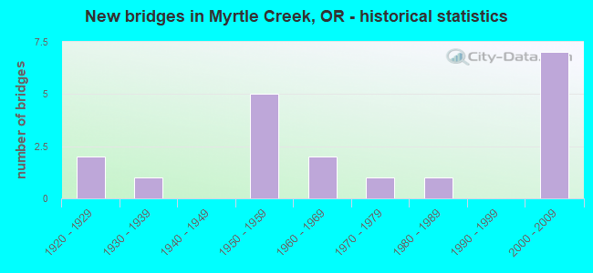
- New bridges - historical statistics
- 21920-1929
- 11930-1939
- 51950-1959
- 21960-1969
- 11970-1979
- 11980-1989
- 72000-2009

- Reconstructed bridges - Historical Statistics
- 11960-1969
- 11970-1979
- 01980-1989
- 31990-1999
- 12000-2009


- Bridge Condition - Deck
- 21.4%Good
- 71.4%Satisfactory
- 7.1%Fair

- Bridge Condition - Superstructure
- 21.4%Good
- 78.6%Satisfactory

- Bridge Condition - Substructure
- 14.3%Good
- 42.9%Satisfactory
- 35.7%Fair
- 7.1%Critical

- Bridge Condition - Channel
- 50.0%Good
- 25.0%Satisfactory
- 25.0%Fair
Find on map >> Show street view
Structure Number: 7841A001 11257, Location: 114 MI S OF ROSEBURG SCL (Lat: 43.064047, Lng: -123.348503), Route carried "on" structure: Interstate 5, Year Built: 1965, Year Reconstructed: 1983, Status: Open, Structure Length: 26.94m (88.39ft), Average Daily Traffic: 12,376 (year 2020), Truck Traffic: 33%, Average Future Daily Traffic: 14,100 (year 2040), Design Load: HS 20, Features Intersected: S UMPQUA R CORP, CO RD
Minimum Vertical Clearance: 30+ m (98+ ft), Kilometerpoint: 181.164, Lanes on structure: 2, Lanes under structure: 4, Base Highway Network: Yes, Owner: State Highway Agency, Approaching Roadway Width: 9.1m (29.9ft), Skew: 9 degrees, Material/Design: Steel, Design/Construction: Truss - Deck, Number Of Spans In Main Unit: 1, Number Of Approach Spans: 8, Length of Maximum Span: 84.4m (276.9ft), Curb-To-Curb Width: 9.1m (29.9ft), Out-to-Out Width: 11.0m (36.1ft)
Condition: Deck: Satisfactory, Superstructure: Satisfactory, Substructure: Satisfactory, Channel: Good, Operating Rating: 23.3 metric tons, Method Used To Determine Operating Rating: Load and Resistance Factor Rating (LRFR) rating reported by rating factor(RF) method using HL-93 loadings, Inventory Rating: 17.8 metric tons, Method Used To Determine Inventory Rating: Load and Resistance Factor Rating (LRFR) rating reported by rating factor(RF) method using HL-93 loadings, Structural Evaluation: Meets minimum limits, Deck Geometry: Meets minimum limits, Underclear: High priority of corrective action, Waterway Adequacy: Superior to present desirable criteria, Approach Roadway Alignment: Equal to present desirable criteria, Length Of Structure Improvement: 26.90m (88.25ft), Designated Inspection Frequency: Every 24 months, Critical Feature Inspection Frequency: Every 24 months, Inspection Date: September 2020, Critical Feature Inspection Date: September 2020, Bridge Improvement Cost: $3,318,000, Roadway Improvement Cost: $332,000, Total Project Cost: $5,309,000, Deck Structure Type: Concrete Cast-file-Place, Wearing Surface/Protective System: Wearing Surface: Latex Concrete
Find on map >> Show street view
Structure Number: 7950 001 10831, Location: 09.2 MI N OF CANYONVILLE (Lat: 43.025850, Lng: -123.299361), Route carried "on" structure: Interstate 5, Year Built: 1958, Year Reconstructed: 1999, Status: Open, Structure Length: 6.22m (20.41ft), Average Daily Traffic: 26,631 (year 2020), Truck Traffic: 33%, Average Future Daily Traffic: 30,400 (year 2040), Design Load: HS 20, Features Intersected: MYRTLE CR INTER
Minimum Vertical Clearance: 30+ m (98+ ft), Kilometerpoint: 174.308, Lanes on structure: 4, Lanes under structure: 2, Base Highway Network: Yes, Owner: State Highway Agency, Approaching Roadway Width: 27.6m (90.6ft), Skew: 34 degrees, Material/Design: Concrete continuous, Design/Construction: Tee Beam, Number Of Spans In Main Unit: 4, Length of Maximum Span: 23.5m (77.1ft), Curb-To-Curb Width: 27.6m (90.6ft), Out-to-Out Width: 29.0m (95.1ft)
Condition: Deck: Satisfactory, Superstructure: Satisfactory, Substructure: Satisfactory, Operating Rating: 44.7 metric tons, Method Used To Determine Operating Rating: Load and Resistance Factor Rating (LRFR) rating reported by rating factor(RF) method using HL-93 loadings, Inventory Rating: 34.3 metric tons, Method Used To Determine Inventory Rating: Load and Resistance Factor Rating (LRFR) rating reported by rating factor(RF) method using HL-93 loadings, Structural Evaluation: Equal to present minimum criteria, Deck Geometry: Superior to present desirable criteria, Underclear: Equal to present minimum criteria, Approach Roadway Alignment: Equal to present desirable criteria, Designated Inspection Frequency: Every 24 months, Inspection Date: January 2021, Deck Structure Type: Concrete Cast-file-Place, Wearing Surface/Protective System: Wearing Surface: Bituminous, Membrane: Preformed Fabric
Find on map >> Show street view
Structure Number: 7952A001 10752, Location: 08.4 MI N OF CANYONVILLE (Lat: 43.015850, Lng: -123.301019), Route carried "on" structure: Interstate 5, Year Built: 1958, Year Reconstructed: 1999, Status: Open, Structure Length: 8.02m (26.31ft), Average Daily Traffic: 13,315 (year 2020), Truck Traffic: 33%, Average Future Daily Traffic: 15,200 (year 2040), Design Load: HS 20, Features Intersected: CORP
Minimum Vertical Clearance: 30+ m (98+ ft), Kilometerpoint: 173.037, Lanes on structure: 2, Base Highway Network: Yes, Owner: State Highway Agency, Approaching Roadway Width: 12.6m (41.3ft), Skew: 9 degrees, Material/Design: Concrete continuous, Design/Construction: Tee Beam, Number Of Spans In Main Unit: 5, Length of Maximum Span: 22.3m (73.2ft), Curb-To-Curb Width: 12.6m (41.3ft), Out-to-Out Width: 13.4m (44.0ft)
Condition: Deck: Satisfactory, Superstructure: Satisfactory, Substructure: Fair, Operating Rating: 48.1 metric tons, Method Used To Determine Operating Rating: Load Factor (LF), Inventory Rating: 29.0 metric tons, Method Used To Determine Inventory Rating: Load Factor (LF), Structural Evaluation: Somewhat better than minimum adequacy, Deck Geometry: Better than present minimum criteria, Underclear: Equal to present minimum criteria, Approach Roadway Alignment: Equal to present desirable criteria, Designated Inspection Frequency: Every 24 months, Inspection Date: January 2021, Deck Structure Type: Concrete Cast-file-Place, Wearing Surface/Protective System: Wearing Surface: Bituminous, Membrane: Preformed Fabric
Find on map >> Show street view
Structure Number: 7954 001C10678, Location: 07.7 MI N OF CANYONVILLE (Lat: 43.007061, Lng: -123.308669), Route carried "on" structure: County highway , Year Built: 1958, Status: Open, Structure Length: 3.96m (12.99ft), Average Daily Traffic: 290 (year 2020), Truck Traffic: 10%, Average Future Daily Traffic: 230 (year 2030), Design Load: HS 20, Features Intersected: CORP, Facility Carried by Structure: WEAVER ROAD
Minimum Vertical Clearance: 30+ m (98+ ft), Kilometerpoint: 171.846, Lanes on structure: 2, Owner: State Highway Agency, Approaching Roadway Width: 7.9m (25.9ft), Material/Design: Concrete continuous, Design/Construction: Tee Beam, Number Of Spans In Main Unit: 3, Length of Maximum Span: 15.2m (49.9ft), Curb-To-Curb Width: 7.9m (25.9ft), Out-to-Out Width: 9.4m (30.8ft)
Condition: Deck: Good, Superstructure: Satisfactory, Substructure: Satisfactory, Operating Rating: 30.8 metric tons, Method Used To Determine Operating Rating: Load and Resistance Factor Rating (LRFR) rating reported by rating factor(RF) method using HL-93 loadings, Inventory Rating: 23.7 metric tons, Method Used To Determine Inventory Rating: Load and Resistance Factor Rating (LRFR) rating reported by rating factor(RF) method using HL-93 loadings, Structural Evaluation: Equal to present minimum criteria, Deck Geometry: Somewhat better than minimum adequacy, Underclear: Better than present minimum criteria, Approach Roadway Alignment: Equal to present desirable criteria, Designated Inspection Frequency: Every 24 months, Inspection Date: January 2021, Deck Structure Type: Concrete Cast-file-Place, Wearing Surface/Protective System: Wearing Surface: Bituminous
Find on map >> Show street view
Structure Number: 19105 001 11257, Location: 11.4 MI S OF ROSEBURG SCL (Lat: 43.064150, Lng: -123.348261), Route carried "on" structure: Interstate 5, Year Built: 2004, Status: Open, Structure Length: 25.12m (82.41ft), Average Daily Traffic: 12,376 (year 2020), Truck Traffic: 33%, Average Future Daily Traffic: 14,100 (year 2040), Design Load: HL 93, Features Intersected: S UMPQUA R CORP, CO RD
Minimum Vertical Clearance: 30+ m (98+ ft), Kilometerpoint: 181.164, Lanes on structure: 2, Lanes under structure: 4, Base Highway Network: Yes, Owner: State Highway Agency, Approaching Roadway Width: 15.0m (49.2ft), Material/Design: Prestressed concrete continuous, Design/Construction: Box Beam or Girders - Multiple, Number Of Spans In Main Unit: 3, Length of Maximum Span: 92.5m (303.5ft), Curb-To-Curb Width: 15.0m (49.2ft), Out-to-Out Width: 15.8m (51.8ft)
Condition: Deck: Satisfactory, Superstructure: Satisfactory, Substructure: Satisfactory, Channel: Good, Operating Rating: 66.7 metric tons, Method Used To Determine Operating Rating: Load and Resistance Factor Rating (LRFR) rating reported by rating factor(RF) method using HL-93 loadings, Inventory Rating: 51.5 metric tons, Method Used To Determine Inventory Rating: Load and Resistance Factor Rating (LRFR) rating reported by rating factor(RF) method using HL-93 loadings, Structural Evaluation: Equal to present minimum criteria, Deck Geometry: Superior to present desirable criteria, Underclear: High priority of corrective action, Waterway Adequacy: Superior to present desirable criteria, Approach Roadway Alignment: Equal to present desirable criteria, Designated Inspection Frequency: Every 24 months, Inspection Date: January 2021, Deck Structure Type: Concrete Cast-file-Place, Wearing Surface/Protective System: Wearing Surface: Monolithic Concrete
Find on map >> Show street view
Structure Number: 19C030001500155, Location: 1.5 MI NE OF MYRTLE CREEK (Lat: 43.042561, Lng: -123.258011), Route carried "on" structure: County highway A383, Year Built: 1922, Year Reconstructed: 1968, Status: Posted for load, Structure Length: 0.76m (2.49ft), Average Daily Traffic: 2,358 (year 2020), Truck Traffic: 7%, Average Future Daily Traffic: 2,668 (year 2025), Design Load: H 20, Features Intersected: BILGER CREEK, Facility Carried by Structure: COUNTY RD 15
Minimum Vertical Clearance: 30+ m (98+ ft), Kilometerpoint: 2.494, Lanes on structure: 2, Owner: County Highway Agency, Approaching Roadway Width: 12.5m (41.0ft), Material/Design: Steel, Design/Construction: Stringer/Multi-beam, Number Of Spans In Main Unit: 1, Length of Maximum Span: 7.0m (23.0ft), Curb-To-Curb Width: 11.8m (38.7ft), Out-to-Out Width: 12.2m (40.0ft)
Condition: Deck: Satisfactory, Superstructure: Satisfactory, Substructure: Fair, Channel: Fair, Operating Rating: 10.4 metric tons, Method Used To Determine Operating Rating: Load and Resistance Factor Rating (LRFR) rating reported by rating factor(RF) method using HL-93 loadings, Inventory Rating: 8.1 metric tons, Method Used To Determine Inventory Rating: Load and Resistance Factor Rating (LRFR) rating reported by rating factor(RF) method using HL-93 loadings, Structural Evaluation: High priority of corrective action, Deck Geometry: Somewhat better than minimum adequacy, Waterway Adequacy: Equal to present desirable criteria, Approach Roadway Alignment: Equal to present desirable criteria, Bridge Posting: Required (Relationship of Operating Rating to Maximum Legal Load: > 39.9% below), Designated Inspection Frequency: Every 12 months, Inspection Date: June 2021, Deck Structure Type: Concrete Cast-file-Place, Wearing Surface/Protective System: Wearing Surface: Bituminous
Find on map >> Show street view
Structure Number: 19C035 18 076, Location: AT MYRTLE CR SUPER Y (Lat: 43.027481, Lng: -123.276439), Route carried "on" structure: County highway C0018, Year Built: 1957, Year Reconstructed: 1999, Status: Open, Structure Length: 3.38m (11.09ft), Average Daily Traffic: 3,336 (year 2020), Truck Traffic: 5%, Average Future Daily Traffic: 3,771 (year 2025), Design Load: H 20, Features Intersected: N.MYRTLE CREEK/SUPER Y, Facility Carried by Structure: DIVISION ST CR #18
Minimum Vertical Clearance: 30+ m (98+ ft), Kilometerpoint: 1.223, Lanes on structure: 2, Owner: County Highway Agency, Approaching Roadway Width: 7.9m (25.9ft), Skew: 3 degrees, Material/Design: Steel, Design/Construction: Stringer/Multi-beam, Number Of Spans In Main Unit: 3, Length of Maximum Span: 15.2m (49.9ft), Curb or Sidewalk Widths: Left: 0.0m, Right: 0.9m (3.0ft), Curb-To-Curb Width: 7.5m (24.6ft), Out-to-Out Width: 9.9m (32.5ft)
Condition: Deck: Satisfactory, Superstructure: Good, Substructure: Fair, Channel: Satisfactory, Operating Rating: 31.1 metric tons, Method Used To Determine Operating Rating: Load and Resistance Factor Rating (LRFR) rating reported by rating factor(RF) method using HL-93 loadings, Inventory Rating: 24.0 metric tons, Method Used To Determine Inventory Rating: Load and Resistance Factor Rating (LRFR) rating reported by rating factor(RF) method using HL-93 loadings, Structural Evaluation: Somewhat better than minimum adequacy, Deck Geometry: High priority of replacement, Waterway Adequacy: Equal to present desirable criteria, Approach Roadway Alignment: Equal to present desirable criteria, Length Of Structure Improvement: 3.40m (11.15ft), Designated Inspection Frequency: Every 24 months, Inspection Date: June 2021, Bridge Improvement Cost: $355,000, Roadway Improvement Cost: $36,000, Total Project Cost: $569,000, Deck Structure Type: Concrete Cast-file-Place, Wearing Surface/Protective System: Wearing Surface: Monolithic Concrete
Find on map >> Show street view
Structure Number: 19C340 18A 018, Location: IN MYRTLE CREEK (Lat: 43.023161, Lng: -123.285289), Route carried "on" structure: County highway A382, Year Built: 1981, Status: Open, Structure Length: 3.32m (10.89ft), Average Daily Traffic: 5,291 (year 2020), Truck Traffic: 7%, Average Future Daily Traffic: 5,981 (year 2025), Design Load: HS 20, Features Intersected: SOUTH MYRTLE CREEK, Facility Carried by Structure: COUNTY RD 18A
Minimum Vertical Clearance: 30+ m (98+ ft), Kilometerpoint: 0.290, Lanes on structure: 2, Owner: County Highway Agency, Approaching Roadway Width: 9.1m (29.9ft), Skew: 4 degrees, Material/Design: Prestressed concrete, Design/Construction: Box Beam or Girders - Multiple, Number Of Spans In Main Unit: 1, Length of Maximum Span: 32.3m (106.0ft), Curb-To-Curb Width: 12.6m (41.3ft), Out-to-Out Width: 13.5m (44.3ft)
Condition: Deck: Good, Superstructure: Satisfactory, Substructure: Good, Channel: Good, Operating Rating: 33.6 metric tons, Method Used To Determine Operating Rating: Load Factor (LF), Inventory Rating: 20.0 metric tons, Method Used To Determine Inventory Rating: Load Factor (LF), Structural Evaluation: Somewhat better than minimum adequacy, Deck Geometry: Somewhat better than minimum adequacy, Waterway Adequacy: Equal to present desirable criteria, Approach Roadway Alignment: Better than present minimum criteria, Designated Inspection Frequency: Every 24 months, Inspection Date: June 2021, Deck Structure Type: Other, Wearing Surface/Protective System: Wearing Surface: Bituminous
Find on map >> Show street view
Structure Number: 19C513 386 04, Location: AT W MYRTLE CREEK CITY (Lat: 43.025161, Lng: -123.295961), Route carried "on" structure: County highway A414, Year Built: 1922, Year Reconstructed: 2007, Status: Posted for load, Structure Length: 18.20m (59.71ft), Average Daily Traffic: 11,004 (year 2020), Truck Traffic: 7%, Average Future Daily Traffic: 11,754 (year 2025), Design Load: H 15, Features Intersected: SOUTH UMPQUA RIVER, Facility Carried by Structure: COUNTY RD 386
Minimum Vertical Clearance: 30+ m (98+ ft), Kilometerpoint: 0.644, Lanes on structure: 2, Owner: County Highway Agency, Approaching Roadway Width: 7.9m (25.9ft), Material/Design: Concrete continuous, Design/Construction: Arch - Deck, Number Of Spans In Main Unit: 3, Number Of Approach Spans: 8, Length of Maximum Span: 39.6m (129.9ft), Curb-To-Curb Width: 7.9m (25.9ft), Out-to-Out Width: 8.7m (28.5ft)
Condition: Deck: Satisfactory, Superstructure: Satisfactory, Substructure: Fair, Channel: Good, Operating Rating: 16.5 metric tons, Method Used To Determine Operating Rating: Load and Resistance Factor Rating (LRFR) rating reported by rating factor(RF) method using HL-93 loadings, Inventory Rating: 13.0 metric tons, Method Used To Determine Inventory Rating: Load and Resistance Factor Rating (LRFR) rating reported by rating factor(RF) method using HL-93 loadings, Structural Evaluation: High priority of corrective action, Deck Geometry: High priority of corrective action, Underclear: Equal to present minimum criteria, Waterway Adequacy: Equal to present desirable criteria, Approach Roadway Alignment: Equal to present minimum criteria, Bridge Posting: Required (Relationship of Operating Rating to Maximum Legal Load: 30.0 - 39.9% below), Designated Inspection Frequency: Every 12 months, Underwater Inspection Frequency: Every 60 months, Inspection Date: July 2021, Underwater Inspection Date: June 2018, Deck Structure Type: Concrete Cast-file-Place, Wearing Surface/Protective System: Wearing Surface: Monolithic Concrete
Find on map >> Show street view
Structure Number: 19C514 386 089, Location: IN MYRTLE CREEK @ DQ (Lat: 43.023817, Lng: -123.288253), Route carried "on" structure: County highway A414, Year Built: 1930, Status: Open, Structure Length: 3.72m (12.20ft), Average Daily Traffic: 15,228 (year 2020), Truck Traffic: 7%, Average Future Daily Traffic: 21,014 (year 2025), Design Load: H 15, Features Intersected: MYRTLE CREEK, Facility Carried by Structure: COUNTY RD 386
Minimum Vertical Clearance: 30+ m (98+ ft), Kilometerpoint: 1.432, Lanes on structure: 2, Owner: County Highway Agency, Approaching Roadway Width: 8.2m (26.9ft), Material/Design: Concrete continuous, Design/Construction: Tee Beam, Number Of Spans In Main Unit: 3, Length of Maximum Span: 18.3m (60.0ft), Curb or Sidewalk Widths: Left: 1.1m (3.6ft), Right: 1.1m (3.6ft), Curb-To-Curb Width: 8.2m (26.9ft), Out-to-Out Width: 11.1m (36.4ft)
Condition: Deck: Fair, Superstructure: Satisfactory, Substructure: Fair, Channel: Satisfactory, Operating Rating: 48.1 metric tons, Method Used To Determine Operating Rating: Load Factor (LF), Inventory Rating: 29.0 metric tons, Method Used To Determine Inventory Rating: Load Factor (LF), Structural Evaluation: Somewhat better than minimum adequacy, Deck Geometry: High priority of replacement, Waterway Adequacy: Better than present minimum criteria, Approach Roadway Alignment: Equal to present desirable criteria, Length Of Structure Improvement: 3.70m (12.14ft), Designated Inspection Frequency: Every 24 months, Inspection Date: July 2021, Bridge Improvement Cost: $391,000, Roadway Improvement Cost: $39,000, Total Project Cost: $625,000, Deck Structure Type: Concrete Cast-file-Place, Wearing Surface/Protective System: Wearing Surface: Bituminous
Find on map >> Show street view
Structure Number: 20303 001 10752, Location: 08.4 MI N OF CANYONVILLE (Lat: 43.015889, Lng: -123.300850), Route carried "on" structure: Interstate 5, Year Built: 2008, Status: Open, Structure Length: 7.50m (24.61ft), Average Daily Traffic: 13,315 (year 2020), Truck Traffic: 33%, Average Future Daily Traffic: 15,200 (year 2040), Design Load: HL 93, Features Intersected: CORP
Minimum Vertical Clearance: 30+ m (98+ ft), Kilometerpoint: 173.037, Lanes on structure: 2, Base Highway Network: Yes, Owner: State Highway Agency, Approaching Roadway Width: 13.4m (44.0ft), Skew: 4 degrees, Material/Design: Prestressed concrete continuous, Design/Construction: Stringer/Multi-beam, Number Of Spans In Main Unit: 2, Length of Maximum Span: 39.9m (130.9ft), Curb-To-Curb Width: 13.4m (44.0ft), Out-to-Out Width: 14.3m (46.9ft)
Condition: Deck: Good, Superstructure: Good, Substructure: Good, Operating Rating: 53.8 metric tons, Method Used To Determine Operating Rating: Load and Resistance Factor Rating (LRFR) rating reported by rating factor(RF) method using HL-93 loadings, Inventory Rating: 41.5 metric tons, Method Used To Determine Inventory Rating: Load and Resistance Factor Rating (LRFR) rating reported by rating factor(RF) method using HL-93 loadings, Structural Evaluation: Better than present minimum criteria, Deck Geometry: Superior to present desirable criteria, Underclear: Superior to present desirable criteria, Approach Roadway Alignment: Equal to present desirable criteria, Designated Inspection Frequency: Every 24 months, Inspection Date: January 2021, Deck Structure Type: Concrete Cast-file-Place, Wearing Surface/Protective System: Wearing Surface: Monolithic Concrete
Find on map >> Show street view
Structure Number: 20627 001C10671, Location: 07.6 MI N OF CANYONVILLE (Lat: 43.006400, Lng: -123.307811), Route carried "on" structure: County highway , Year Built: 2008, Status: Open, Structure Length: 5.55m (18.21ft), Average Daily Traffic: 290 (year 2020), Truck Traffic: 10%, Average Future Daily Traffic: 356 (year 2030), Design Load: HL 93, Features Intersected: I-5, (HWY 001), Facility Carried by Structure: WEAVER ROAD
Minimum Vertical Clearance: 30+ m (98+ ft), Kilometerpoint: 171.733, Lanes on structure: 2, Lanes under structure: 4, Owner: State Highway Agency, Approaching Roadway Width: 17.7m (58.1ft), Material/Design: Prestressed concrete continuous, Design/Construction: Box Beam or Girders - Multiple, Number Of Spans In Main Unit: 2, Length of Maximum Span: 27.7m (90.9ft), Curb-To-Curb Width: 17.7m (58.1ft), Out-to-Out Width: 18.6m (61.0ft)
Condition: Deck: Satisfactory, Superstructure: Satisfactory, Substructure: Satisfactory, Operating Rating: 39.5 metric tons, Method Used To Determine Operating Rating: Load and Resistance Factor Rating (LRFR) rating reported by rating factor(RF) method using HL-93 loadings, Inventory Rating: 30.5 metric tons, Method Used To Determine Inventory Rating: Load and Resistance Factor Rating (LRFR) rating reported by rating factor(RF) method using HL-93 loadings, Structural Evaluation: Equal to present minimum criteria, Deck Geometry: Superior to present desirable criteria, Underclear: Equal to present minimum criteria, Approach Roadway Alignment: Equal to present desirable criteria, Designated Inspection Frequency: Every 24 months, Inspection Date: January 2021, Deck Structure Type: Concrete Cast-file-Place, Wearing Surface/Protective System: Wearing Surface: Monolithic Concrete
Find on map >> Show street view
Structure Number: 20717 001 11035, Location: 11.2 MI N OF CANYONVILLE (Lat: 43.037831, Lng: -123.332731), Route carried "on" structure: Interstate 5, Year Built: 2008, Status: Open, Structure Length: 2.56m (8.40ft), Average Daily Traffic: 26,616 (year 2020), Truck Traffic: 33%, Average Future Daily Traffic: 30,600 (year 2040), Design Load: HL 93, Features Intersected: BOOMER HILL RD
Minimum Vertical Clearance: 30+ m (98+ ft), Kilometerpoint: 177.591, Lanes on structure: 4, Lanes under structure: 2, Base Highway Network: Yes, Owner: State Highway Agency, Approaching Roadway Width: 28.7m (94.2ft), Skew: 33 degrees, Material/Design: Prestressed concrete, Design/Construction: Slab, Number Of Spans In Main Unit: 1, Length of Maximum Span: 25.6m (84.0ft), Curb-To-Curb Width: 28.7m (94.2ft), Out-to-Out Width: 30.2m (99.1ft)
Condition: Deck: Satisfactory, Superstructure: Satisfactory, Substructure: Satisfactory, Operating Rating: 75.5 metric tons, Method Used To Determine Operating Rating: Load and Resistance Factor Rating (LRFR) rating reported by rating factor(RF) method using HL-93 loadings, Inventory Rating: 58.3 metric tons, Method Used To Determine Inventory Rating: Load and Resistance Factor Rating (LRFR) rating reported by rating factor(RF) method using HL-93 loadings, Structural Evaluation: Equal to present minimum criteria, Deck Geometry: Superior to present desirable criteria, Underclear: Equal to present minimum criteria, Approach Roadway Alignment: Equal to present desirable criteria, Designated Inspection Frequency: Every 24 months, Inspection Date: January 2021, Deck Structure Type: Concrete Cast-file-Place, Wearing Surface/Protective System: Wearing Surface: Monolithic Concrete
Find on map >> Show street view
Structure Number: 26T1, Location: CITY OF MYRTLE CREEK (Lat: 43.026092, Lng: -123.278278), Route carried "on" structure: City street , Year Built: 1976, Status: Posted for load, Structure Length: 2.62m (8.60ft), Average Daily Traffic: 331 (year 2020), Truck Traffic: 10%, Average Future Daily Traffic: 374 (year 2025), Design Load: H 20, Features Intersected: NORTH MYRTLE CREEK, Facility Carried by Structure: NE JOHNSON STREET
Minimum Vertical Clearance: 30+ m (98+ ft), Kilometerpoint: 0.805, Lanes on structure: 2, Owner: City or Municipal Highway Agency, Approaching Roadway Width: 9.8m (32.2ft), Material/Design: Steel, Design/Construction: Stringer/Multi-beam, Number Of Spans In Main Unit: 3, Length of Maximum Span: 9.1m (29.9ft), Curb or Sidewalk Widths: Left: 0.2m (0.7ft), Right: 1.4m (4.6ft), Curb-To-Curb Width: 9.8m (32.2ft), Out-to-Out Width: 11.9m (39.0ft)
Condition: Deck: Satisfactory, Superstructure: Good, Substructure: Critical, Channel: Fair, Operating Rating: 21.1 metric tons, Method Used To Determine Operating Rating: Load and Resistance Factor Rating (LRFR) rating reported by rating factor(RF) method using HL-93 loadings, Inventory Rating: 16.2 metric tons, Method Used To Determine Inventory Rating: Load and Resistance Factor Rating (LRFR) rating reported by rating factor(RF) method using HL-93 loadings, Structural Evaluation: High priority of replacement, Deck Geometry: Better than present minimum criteria, Waterway Adequacy: Equal to present minimum criteria, Approach Roadway Alignment: Equal to present desirable criteria, Bridge Posting: Required (Relationship of Operating Rating to Maximum Legal Load: 10.0 - 19.9% below), Length Of Structure Improvement: 3.40m (11.15ft), Designated Inspection Frequency: Every 12 months, Underwater Inspection Frequency: Every 36 months, Inspection Date: June 2021, Underwater Inspection Date: June 2021, Bridge Improvement Cost: $358,000, Roadway Improvement Cost: $36,000, Total Project Cost: $573,000, Deck Structure Type: Concrete Cast-file-Place, Wearing Surface/Protective System: Wearing Surface: Monolithic Concrete
Find on map >> Show street view
Structure Number: 7841A001 11257, Location: 114 MI S OF ROSEBURG SCL (Lat: 43.064047, Lng: -123.348503), Route carried "under" structure: State highway 99, Year Built: 1965, Structure Length: 0. m, Average Daily Traffic: 15,014 (year 2020), Truck Traffic: 10%, Features Intersected: S UMPQUA R CORP, CO RD, Facility Carried by Structure: I-5 (HWY 001) SB
Minimum Vertical Clearance: 9.14m (29.99ft), Kilometerpoint: 181.164, Lanes on structure: 2, Lanes under structure: 4, Material/Design: Steel, Design/Construction: Truss - Deck, Length of Maximum Span: 84.4m (276.9ft)
Find on map >> Show street view
Structure Number: 7950 001 10831, Location: 09.2 MI N OF CANYONVILLE (Lat: 43.025850, Lng: -123.299361), Route carried "under" structure: State highway 5, Year Built: 1958, Structure Length: 0. m, Average Daily Traffic: 26,631 (year 2020), Truck Traffic: 33%, Features Intersected: MYRTLE CR INTER
Minimum Vertical Clearance: 5.59m (18.34ft), Kilometerpoint: 174.308, Lanes on structure: 4, Lanes under structure: 2, Material/Design: Concrete continuous, Design/Construction: Tee Beam, Length of Maximum Span: 23.5m (77.1ft)
Find on map >> Show street view
Structure Number: 19105 001 11257, Location: 11.4 MI S OF ROSEBURG SCL (Lat: 43.064150, Lng: -123.348261), Route carried "under" structure: State highway 99, Year Built: 2004, Structure Length: 0. m, Average Daily Traffic: 15,014 (year 2020), Truck Traffic: 10%, Features Intersected: S UMPQUA R CORP, CO RD, Facility Carried by Structure: I-5 (HWY 001) NB
Minimum Vertical Clearance: 9.14m (29.99ft), Kilometerpoint: 181.164, Lanes on structure: 2, Lanes under structure: 4, Material/Design: Prestressed concrete continuous, Design/Construction: Box Beam or Girders - Multiple, Length of Maximum Span: 92.5m (303.5ft)
Find on map >> Show street view
Structure Number: 20627 001C10671, Location: 07.6 MI N OF CANYONVILLE (Lat: 43.006400, Lng: -123.307811), Route carried "under" structure: Interstate 5, Year Built: 2008, Structure Length: 0. m, Average Daily Traffic: 24,942 (year 2020), Truck Traffic: 33%, Features Intersected: I-5, (HWY 001), Facility Carried by Structure: WEAVER ROAD
Minimum Vertical Clearance: 5.54m (18.18ft), Kilometerpoint: 171.733, Lanes on structure: 2, Lanes under structure: 4, Material/Design: Prestressed concrete continuous, Design/Construction: Box Beam or Girders - Multiple, Length of Maximum Span: 27.7m (90.9ft)
Find on map >> Show street view
Structure Number: 20717 001 11035, Location: 11.2 MI N OF CANYONVILLE (Lat: 43.037831, Lng: -123.332731), Route carried "under" structure: Ramp Interstate 5, Year Built: 2008, Structure Length: 0. m, Average Daily Traffic: 26,616 (year 2020), Truck Traffic: 33%, Features Intersected: BOOMER HILL RD
Minimum Vertical Clearance: 5.13m (16.83ft), Kilometerpoint: 177.591, Lanes on structure: 4, Lanes under structure: 2, Material/Design: Prestressed concrete, Design/Construction: Slab, Length of Maximum Span: 25.6m (84.0ft)