Bridge Statistics for Murrieta, California (CA)
Condition, Traffic, Stress, Structural Evaluation, Project Costs
- National Bridge Inventory (NBI) Statistics
- 43Number of bridges
- 495ft / 151mTotal length
- 1,346,471Total average daily traffic
- 84,645Total average daily truck traffic
- National Bridge Inventory (NBI) Registered Bridges for Murrieta
- No street view available for this location
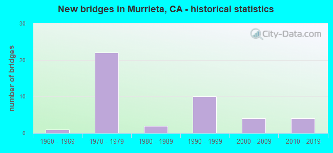
- New bridges - historical statistics
- 11960-1969
- 221970-1979
- 21980-1989
- 101990-1999
- 42000-2009
- 42010-2019
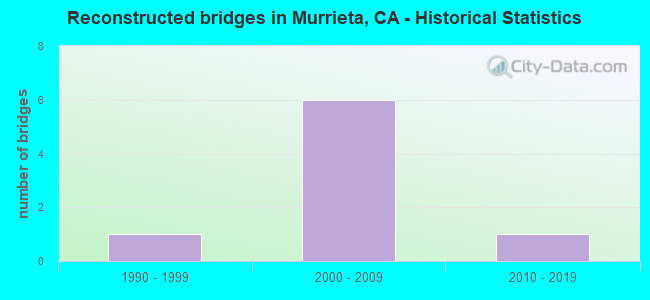
- Reconstructed bridges - Historical Statistics
- 11990-1999
- 62000-2009
- 12010-2019
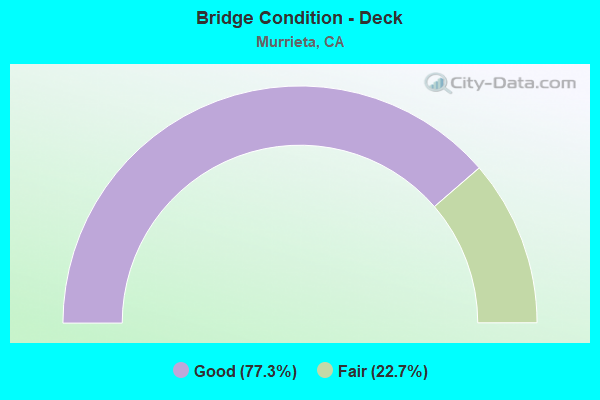
- Bridge Condition - Deck
- 77.3%Good
- 22.7%Fair
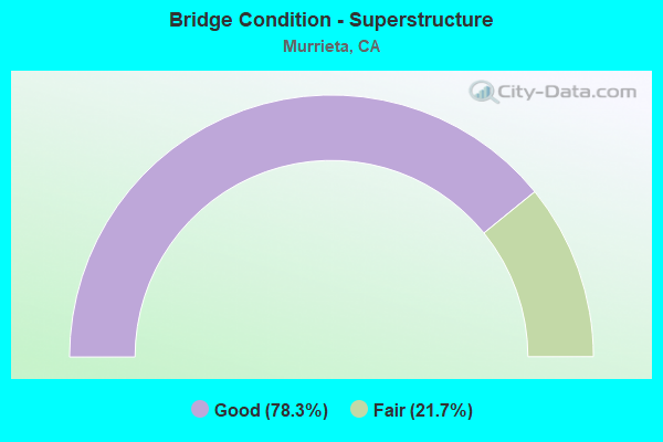
- Bridge Condition - Superstructure
- 78.3%Good
- 21.7%Fair
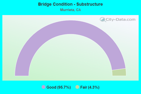
- Bridge Condition - Substructure
- 95.7%Good
- 4.3%Fair
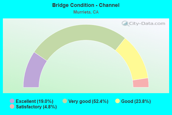
- Bridge Condition - Channel
- 19.0%Excellent
- 52.4%Very good
- 23.8%Good
- 4.8%Satisfactory
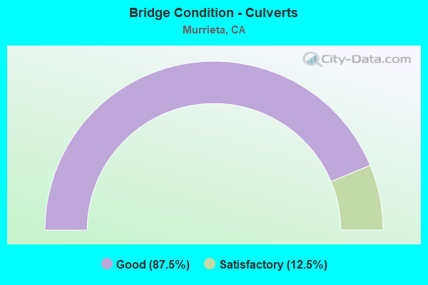
- Bridge Condition - Culverts
- 87.5%Good
- 12.5%Satisfactory
Find on map >> Show street view
Structure Number: 56 0651, Location: 08-RIV-215-R12.51-MRTA (Lat: 33.598544, Lng: -117.175067), Route carried "on" structure: County highway , Year Built: 1979, Year Reconstructed: 2011, Status: Open, Structure Length: 9.30m (30.51ft), Average Daily Traffic: 93,000 (year 2012), Truck Traffic: 7%, Average Future Daily Traffic: 147,924 (year 2038), Design Load: HS 20, Features Intersected: INTERSTATE 215, Facility Carried by Structure: CLINTON KEITH RD
Minimum Vertical Clearance: 30+ m (98+ ft), Kilometerpoint: 0.000, Lanes on structure: 6, Lanes under structure: 8, Owner: State Highway Agency, Approaching Roadway Width: 25.6m (84.0ft), Skew: 31 degrees, Material/Design: Concrete continuous, Design/Construction: Box Beam or Girders - Multiple, Number Of Spans In Main Unit: 2, Length of Maximum Span: 47.8m (156.8ft), Curb or Sidewalk Widths: Left: 1.8m (5.9ft), Right: 1.8m (5.9ft), Curb-To-Curb Width: 25.6m (84.0ft), Out-to-Out Width: 30.6m (100.4ft)
Condition: Deck: Good, Superstructure: Good, Substructure: Good, Operating Rating: 99.8 metric tons, Method Used To Determine Operating Rating: Load Factor (LF), Inventory Rating: 68.0 metric tons, Method Used To Determine Inventory Rating: Load Factor (LF), Structural Evaluation: Better than present minimum criteria, Deck Geometry: Somewhat better than minimum adequacy, Underclear: Meets minimum limits, Approach Roadway Alignment: Equal to present desirable criteria, Designated Inspection Frequency: Every 24 months, Inspection Date: August 2020, Deck Structure Type: Concrete Cast-file-Place
Find on map >> Show street view
Structure Number: 56 0652, Location: 08-RIV-215-R14.50 (Lat: 33.626858, Lng: -117.170992), Route carried "on" structure: State highway 215, Year Built: 1979, Year Reconstructed: 2012, Status: Open, Structure Length: 3.57m (11.71ft), Average Daily Traffic: 83,000 (year 2010), Truck Traffic: 8%, Average Future Daily Traffic: 129,913 (year 2038), Design Load: HS 20, Features Intersected: KELLER ROAD
Minimum Vertical Clearance: 30+ m (98+ ft), Kilometerpoint: 14.500, Lanes on structure: 6, Lanes under structure: 2, Base Highway Network: Yes (Inventory Route: 2, Subroute: 1), Owner: State Highway Agency, Approaching Roadway Width: 33.7m (110.6ft), Skew: 30 degrees, Material/Design: Prestressed concrete, Design/Construction: Box Beam or Girders - Multiple, Number Of Spans In Main Unit: 1, Length of Maximum Span: 35.7m (117.1ft), Curb-To-Curb Width: 33.7m (110.6ft), Out-to-Out Width: 35.4m (116.1ft)
Condition: Deck: Good, Superstructure: Good, Substructure: Good, Operating Rating: 96.2 metric tons, Method Used To Determine Operating Rating: Load Factor (LF), Inventory Rating: 32.4 metric tons, Method Used To Determine Inventory Rating: Load Factor (LF), Structural Evaluation: Better than present minimum criteria, Deck Geometry: Superior to present desirable criteria, Underclear: Equal to present minimum criteria, Approach Roadway Alignment: Equal to present desirable criteria, Designated Inspection Frequency: Every 24 months, Inspection Date: August 2020, Deck Structure Type: Concrete Cast-file-Place
Find on map >> Show street view
Structure Number: 56 0658, Location: 08-RIV-215-R9.51-MRTA (Lat: 33.556086, Lng: -117.181342), Route carried "on" structure: County highway , Year Built: 1977, Year Reconstructed: 2000, Status: Open, Structure Length: 6.64m (21.78ft), Average Daily Traffic: 35,000 (year 2012), Truck Traffic: 7%, Average Future Daily Traffic: 70,000 (year 2038), Design Load: HS 20+Mod, Features Intersected: INTERSTATE 215 & RAMPS, Facility Carried by Structure: MURRIETA HOT SP RD
Minimum Vertical Clearance: 30+ m (98+ ft), Kilometerpoint: 0.000, Lanes on structure: 6, Lanes under structure: 7, Owner: State Highway Agency, Approaching Roadway Width: 24.2m (79.4ft), Skew: 20 degrees, Material/Design: Prestressed concrete continuous, Design/Construction: Box Beam or Girders - Multiple, Number Of Spans In Main Unit: 2, Length of Maximum Span: 45.7m (149.9ft), Curb or Sidewalk Widths: Left: 1.5m (4.9ft), Right: 1.5m (4.9ft), Curb-To-Curb Width: 24.2m (79.4ft), Out-to-Out Width: 29.2m (95.8ft)
Condition: Deck: Good, Superstructure: Good, Substructure: Good, Operating Rating: 82.9 metric tons, Method Used To Determine Operating Rating: Load Factor (LF), Inventory Rating: 32.4 metric tons, Method Used To Determine Inventory Rating: Load Factor (LF), Structural Evaluation: Better than present minimum criteria, Deck Geometry: Somewhat better than minimum adequacy, Underclear: Better than present minimum criteria, Approach Roadway Alignment: Equal to present desirable criteria, Designated Inspection Frequency: Every 24 months, Inspection Date: August 2020, Deck Structure Type: Concrete Cast-file-Place
Find on map >> Show street view
Structure Number: 56 0659, Location: 08-RIV-215-R10.65-MRTA (Lat: 33.572589, Lng: -117.181178), Route carried "on" structure: County highway W560, Year Built: 1979, Year Reconstructed: 2006, Status: Open, Structure Length: 6.00m (19.69ft), Average Daily Traffic: 35,000 (year 2012), Truck Traffic: 7%, Average Future Daily Traffic: 50,000 (year 2038), Design Load: HS 20, Features Intersected: INTERSTATE 215, Facility Carried by Structure: LOS ALAMOS RD
Minimum Vertical Clearance: 30+ m (98+ ft), Kilometerpoint: 0.000, Lanes on structure: 7, Lanes under structure: 6, Owner: State Highway Agency, Approaching Roadway Width: 32.3m (106.0ft), Skew: 3 degrees, Material/Design: Prestressed concrete continuous, Design/Construction: Box Beam or Girders - Multiple, Number Of Spans In Main Unit: 2, Length of Maximum Span: 30.2m (99.1ft), Curb or Sidewalk Widths: Left: 1.8m (5.9ft), Right: 1.8m (5.9ft), Curb-To-Curb Width: 32.3m (106.0ft), Out-to-Out Width: 36.6m (120.1ft)
Condition: Deck: Good, Superstructure: Good, Substructure: Good, Operating Rating: 72.3 metric tons, Method Used To Determine Operating Rating: Load Factor (LF), Inventory Rating: 32.4 metric tons, Method Used To Determine Inventory Rating: Load Factor (LF), Structural Evaluation: Better than present minimum criteria, Deck Geometry: Superior to present desirable criteria, Underclear: Meets minimum limits, Approach Roadway Alignment: Equal to present desirable criteria, Designated Inspection Frequency: Every 24 months, Inspection Date: August 2020, Deck Structure Type: Concrete Cast-file-Place
Find on map >> Show street view
Structure Number: 56 07, Location: 08-RIV-015-9.47 (Lat: 33.554519, Lng: -117.192483), Route carried "on" structure: County highway , Year Built: 1977, Year Reconstructed: 2000, Status: Open, Structure Length: 11.46m (37.60ft), Average Daily Traffic: 6,000 (year 2021), Truck Traffic: 1%, Average Future Daily Traffic: 6,891 (year 2039), Design Load: HS 20, Features Intersected: INTERSTATE 15, Facility Carried by Structure: MURIETTA HOT SPR
Minimum Vertical Clearance: 30+ m (98+ ft), Kilometerpoint: 0.000, Lanes on structure: 7, Lanes under structure: 7, Owner: State Highway Agency, Approaching Roadway Width: 29.9m (98.1ft), Skew: 14 degrees, Material/Design: Prestressed concrete continuous, Design/Construction: Box Beam or Girders - Multiple, Number Of Spans In Main Unit: 2, Length of Maximum Span: 57.7m (189.3ft), Curb or Sidewalk Widths: Left: 1.5m (4.9ft), Right: 1.5m (4.9ft), Curb-To-Curb Width: 29.9m (98.1ft), Out-to-Out Width: 33.5m (109.9ft)
Condition: Deck: Good, Superstructure: Good, Substructure: Good, Operating Rating: 77.8 metric tons, Method Used To Determine Operating Rating: Load Factor (LF), Inventory Rating: 32.4 metric tons, Method Used To Determine Inventory Rating: Load Factor (LF), Structural Evaluation: Better than present minimum criteria, Deck Geometry: Equal to present minimum criteria, Underclear: Equal to present minimum criteria, Approach Roadway Alignment: Superior to present desirable criteria, Designated Inspection Frequency: Every 24 months, Inspection Date: December 2021, Deck Structure Type: Concrete Cast-file-Place
Find on map >> Show street view
Structure Number: 56 0701, Location: 08-RIV-015-47.52 (Lat: 33.964486, Lng: -117.549228), Route carried "on" structure: County highway , Year Built: 1988, Status: Open, Structure Length: 6.86m (22.51ft), Average Daily Traffic: 2,000 (year 2012), Truck Traffic: 1%, Average Future Daily Traffic: 2,316 (year 2037), Design Load: HS 20+Mod, Features Intersected: INTERSTATE 15, Facility Carried by Structure: 68TH STREET
Minimum Vertical Clearance: 30+ m (98+ ft), Kilometerpoint: 0.000, Lanes on structure: 2, Lanes under structure: 6, Owner: State Highway Agency, Approaching Roadway Width: 12.2m (40.0ft), Material/Design: Prestressed concrete continuous, Design/Construction: Box Beam or Girders - Multiple, Number Of Spans In Main Unit: 2, Length of Maximum Span: 34.4m (112.9ft), Curb or Sidewalk Widths: Left: 1.5m (4.9ft), Right: 0.0m, Curb-To-Curb Width: 12.2m (40.0ft), Out-to-Out Width: 14.6m (47.9ft)
Condition: Deck: Good, Superstructure: Fair, Substructure: Good, Operating Rating: 54.1 metric tons, Method Used To Determine Operating Rating: Assigned rating based on Load Factor Design (LFD) reported in metric tons, Inventory Rating: 32.4 metric tons, Method Used To Determine Inventory Rating: Assigned rating based on Load Factor Design (LFD) reported in metric tons, Structural Evaluation: Somewhat better than minimum adequacy, Deck Geometry: Better than present minimum criteria, Underclear: Equal to present minimum criteria, Approach Roadway Alignment: Superior to present desirable criteria, Designated Inspection Frequency: Every 24 months, Inspection Date: March 2020, Deck Structure Type: Concrete Cast-file-Place
Find on map >> Show street view
Structure Number: 56 0702F, Location: 08-RIV-215-R8.94-MRTA (Lat: 33.548228, Lng: -117.181389), Route carried "on" structure: Ramp State highway 215, Year Built: 1977, Status: Open, Structure Length: 16.28m (53.41ft), Average Daily Traffic: 50,000 (year 2012), Truck Traffic: 7%, Average Future Daily Traffic: 100,000 (year 2038), Design Load: HS 20+Mod, Features Intersected: INTERSTATE 15
Minimum Vertical Clearance: 30+ m (98+ ft), Kilometerpoint: 8.940, Lanes on structure: 2, Lanes under structure: 6, Owner: State Highway Agency, Approaching Roadway Width: 11.6m (38.1ft), Skew: 5 degrees, Material/Design: Prestressed concrete continuous, Design/Construction: Box Beam or Girders - Multiple, Number Of Spans In Main Unit: 4, Length of Maximum Span: 59.7m (195.9ft), Curb-To-Curb Width: 11.6m (38.1ft), Out-to-Out Width: 12.8m (42.0ft)
Condition: Deck: Fair, Superstructure: Good, Substructure: Good, Operating Rating: 99.8 metric tons, Method Used To Determine Operating Rating: Load Factor (LF), Inventory Rating: 32.4 metric tons, Method Used To Determine Inventory Rating: Load Factor (LF), Structural Evaluation: Better than present minimum criteria, Deck Geometry: Superior to present desirable criteria, Underclear: Superior to present desirable criteria, Approach Roadway Alignment: Better than present minimum criteria, Designated Inspection Frequency: Every 24 months, Inspection Date: August 2020, Deck Structure Type: Concrete Cast-file-Place
Find on map >> Show street view
Structure Number: 56 0720R, Location: 08-RIV-015-10.59 (Lat: 33.565689, Lng: -117.206675), Route carried "on" structure: Interstate 15, Year Built: 1979, Year Reconstructed: 2012, Status: Open, Structure Length: 3.92m (12.86ft), Average Daily Traffic: 125,000 (year 2021), Truck Traffic: 7%, Average Future Daily Traffic: 147,433 (year 2039), Design Load: HS 20+Mod, Features Intersected: CALIFORNIA OAKS RD
Minimum Vertical Clearance: 30+ m (98+ ft), Kilometerpoint: 10.590, Lanes on structure: 4, Lanes under structure: 6, Base Highway Network: Yes (, Subroute: 1), Owner: State Highway Agency, Approaching Roadway Width: 20.4m (66.9ft), Skew: 1 degrees, Material/Design: Prestressed concrete, Design/Construction: Box Beam or Girders - Multiple, Number Of Spans In Main Unit: 1, Length of Maximum Span: 39.2m (128.6ft), Curb-To-Curb Width: 20.4m (66.9ft), Out-to-Out Width: 21.7m (71.2ft)
Condition: Deck: Good, Superstructure: Good, Substructure: Good, Operating Rating: 54.1 metric tons, Method Used To Determine Operating Rating: Assigned rating based on Load Factor Design (LFD) reported in metric tons, Inventory Rating: 32.4 metric tons, Method Used To Determine Inventory Rating: Assigned rating based on Load Factor Design (LFD) reported in metric tons, Structural Evaluation: Better than present minimum criteria, Deck Geometry: Equal to present minimum criteria, Underclear: Equal to present minimum criteria, Approach Roadway Alignment: Superior to present desirable criteria, Designated Inspection Frequency: Every 24 months, Inspection Date: December 2021, Deck Structure Type: Concrete Cast-file-Place
Find on map >> Show street view
Structure Number: 56 0831, Location: 08-RIV-215-R13.01-MRTA (Lat: 33.604994, Lng: -117.171939), Route carried "on" structure: City street , Year Built: 2008, Status: Open, Structure Length: 8.20m (26.90ft), Average Daily Traffic: 93,000 (year 2012), Truck Traffic: 7%, Average Future Daily Traffic: 147,924 (year 2038), Design Load: HS 20+Mod, Features Intersected: INTERSTATE 215, ANTELOPE, Facility Carried by Structure: LINNEL LANE
Minimum Vertical Clearance: 30+ m (98+ ft), Kilometerpoint: 0.000, Lanes on structure: 2, Lanes under structure: 8, Owner: State Highway Agency, Approaching Roadway Width: 19.5m (64.0ft), Material/Design: Prestressed concrete continuous, Design/Construction: Box Beam or Girders - Multiple, Number Of Spans In Main Unit: 2, Length of Maximum Span: 44.5m (146.0ft), Curb or Sidewalk Widths: Left: 1.8m (5.9ft), Right: 1.8m (5.9ft), Curb-To-Curb Width: 19.5m (64.0ft), Out-to-Out Width: 23.8m (78.1ft)
Condition: Deck: Good, Superstructure: Good, Substructure: Good, Operating Rating: 54.1 metric tons, Method Used To Determine Operating Rating: Assigned rating based on Load Factor Design (LFD) reported in metric tons, Inventory Rating: 32.4 metric tons, Method Used To Determine Inventory Rating: Assigned rating based on Load Factor Design (LFD) reported in metric tons, Structural Evaluation: Better than present minimum criteria, Deck Geometry: Superior to present desirable criteria, Underclear: Meets minimum limits, Approach Roadway Alignment: Equal to present desirable criteria, Designated Inspection Frequency: Every 24 months, Inspection Date: August 2020, Deck Structure Type: Concrete Cast-file-Place
Find on map >> Show street view
Structure Number: 56C0164, Location: 0.2 MI SW/O WASH AVENUE (Lat: 33.538308, Lng: -117.202014), Route carried "on" structure: City street , Year Built: 1988, Status: Open, Structure Length: 0.94m (3.08ft), Average Daily Traffic: 1,355 (year 2009), Truck Traffic: 1%, Average Future Daily Traffic: 2,532 (year 2044), Design Load: HS 20+Mod, Features Intersected: DE LUZ CREEK, Facility Carried by Structure: GUAVA STREET
Minimum Vertical Clearance: 30+ m (98+ ft), Kilometerpoint: 0.000, Lanes on structure: 2, Owner: City or Municipal Highway Agency, Approaching Roadway Width: 7.3m (24.0ft), Material/Design: Concrete, Design/Construction: Slab, Number Of Spans In Main Unit: 1, Length of Maximum Span: 8.5m (27.9ft), Curb-To-Curb Width: 12.2m (40.0ft), Out-to-Out Width: 12.8m (42.0ft)
Condition: Deck: Good, Superstructure: Good, Substructure: Good, Channel: Good, Operating Rating: 54.1 metric tons, Method Used To Determine Operating Rating: Assigned rating based on Load Factor Design (LFD) reported in metric tons, Inventory Rating: 32.4 metric tons, Method Used To Determine Inventory Rating: Assigned rating based on Load Factor Design (LFD) reported in metric tons, Structural Evaluation: Better than present minimum criteria, Deck Geometry: Better than present minimum criteria, Waterway Adequacy: Equal to present desirable criteria, Approach Roadway Alignment: Equal to present desirable criteria, Designated Inspection Frequency: Every 48 months, Inspection Date: January 2022, Deck Structure Type: Concrete Cast-file-Place
Find on map >> Show street view
Structure Number: 56C022, Location: 25' N/O STETSON AVENUE (Lat: 33.729494, Lng: -116.997564), Route carried "on" structure: City street , Year Built: 1975, Status: Open, Structure Length: 0.88m (2.89ft), Average Daily Traffic: 10,000 (year 2011), Truck Traffic: 1%, Average Future Daily Traffic: 17,505 (year 2043), Design Load: H 20, Features Intersected: STETSON CHANNEL, Facility Carried by Structure: KIRBY STREET
Minimum Vertical Clearance: 30+ m (98+ ft), Kilometerpoint: 0.000, Lanes on structure: 5, Owner: City or Municipal Highway Agency, Approaching Roadway Width: 19.3m (63.3ft), Material/Design: Concrete, Design/Construction: Slab, Number Of Spans In Main Unit: 1, Length of Maximum Span: 8.5m (27.9ft), Curb or Sidewalk Widths: Left: 1.6m (5.2ft), Right: 1.6m (5.2ft), Curb-To-Curb Width: 19.3m (63.3ft), Out-to-Out Width: 22.9m (75.1ft)
Condition: Deck: Fair, Superstructure: Fair, Substructure: Good, Channel: Excellent, Operating Rating: 49.2 metric tons, Method Used To Determine Operating Rating: Load Factor (LF), Inventory Rating: 29.5 metric tons, Method Used To Determine Inventory Rating: Load Factor (LF), Structural Evaluation: Somewhat better than minimum adequacy, Deck Geometry: Meets minimum limits, Waterway Adequacy: Equal to present desirable criteria, Approach Roadway Alignment: Equal to present desirable criteria, Designated Inspection Frequency: Every 24 months, Inspection Date: December 2021, Deck Structure Type: Concrete Cast-file-Place
Find on map >> Show street view
Structure Number: 56C0228, Location: 1.1 MI. NW/O WINCHESTER (Lat: 33.532042, Lng: -117.177278), Route carried "on" structure: City street , Year Built: 1978, Status: Open, Structure Length: 2.44m (8.01ft), Average Daily Traffic: 29,474 (year 2010), Truck Traffic: 1%, Average Future Daily Traffic: 36,547 (year 2042), Design Load: HS 20, Features Intersected: WARM SPRINGS CREEK, Facility Carried by Structure: JEFFERSON AVENUE
Minimum Vertical Clearance: 30+ m (98+ ft), Kilometerpoint: 0.000, Lanes on structure: 4, Base Highway Network: Yes, Owner: City or Municipal Highway Agency, Approaching Roadway Width: 23.2m (76.1ft), Material/Design: Concrete continuous, Design/Construction: Slab, Number Of Spans In Main Unit: 2, Length of Maximum Span: 11.8m (38.7ft), Curb or Sidewalk Widths: Left: 1.5m (4.9ft), Right: 1.5m (4.9ft), Curb-To-Curb Width: 23.2m (76.1ft), Out-to-Out Width: 26.8m (87.9ft)
Condition: Deck: Fair, Superstructure: Fair, Substructure: Good, Channel: Excellent, Operating Rating: 99.8 metric tons, Method Used To Determine Operating Rating: Load Factor (LF), Inventory Rating: 67.7 metric tons, Method Used To Determine Inventory Rating: Load Factor (LF), Structural Evaluation: Somewhat better than minimum adequacy, Deck Geometry: Superior to present desirable criteria, Waterway Adequacy: Superior to present desirable criteria, Approach Roadway Alignment: Equal to present desirable criteria, Designated Inspection Frequency: Every 24 months, Inspection Date: January 2022, Deck Structure Type: Concrete Cast-file-Place
Find on map >> Show street view
Structure Number: 56C0229, Location: 0.9 MI. E/O ROUTE 215 FWY (Lat: 33.554206, Lng: -117.166300), Route carried "on" structure: City street , Year Built: 1973, Year Reconstructed: 2010, Status: Open, Structure Length: 3.02m (9.91ft), Average Daily Traffic: 28,462 (year 2010), Truck Traffic: 1%, Average Future Daily Traffic: 38,734 (year 2042), Design Load: HS 20, Features Intersected: WARM SPRINGS CREEK, Facility Carried by Structure: MURRIETA HOT SP RD
Minimum Vertical Clearance: 30+ m (98+ ft), Kilometerpoint: 0.000, Lanes on structure: 6, Base Highway Network: Yes, Owner: City or Municipal Highway Agency, Approaching Roadway Width: 23.3m (76.4ft), Skew: 2 degrees, Material/Design: Concrete continuous, Design/Construction: Slab, Number Of Spans In Main Unit: 3, Length of Maximum Span: 11.0m (36.1ft), Curb or Sidewalk Widths: Left: 1.5m (4.9ft), Right: 1.8m (5.9ft), Curb-To-Curb Width: 23.3m (76.4ft), Out-to-Out Width: 27.2m (89.2ft)
Condition: Deck: Fair, Superstructure: Fair, Substructure: Good, Channel: Satisfactory, Operating Rating: 88.1 metric tons, Method Used To Determine Operating Rating: Load Factor (LF), Inventory Rating: 52.8 metric tons, Method Used To Determine Inventory Rating: Load Factor (LF), Structural Evaluation: Somewhat better than minimum adequacy, Deck Geometry: Meets minimum limits, Waterway Adequacy: Better than present minimum criteria, Approach Roadway Alignment: Better than present minimum criteria, Designated Inspection Frequency: Every 24 months, Inspection Date: January 2022, Deck Structure Type: Concrete Cast-file-Place
Find on map >> Show street view
Structure Number: 56C0281, Location: 150' SE/O OLIVEWOOD AVE. (Lat: 33.960761, Lng: -117.384336), Route carried "on" structure: City street , Year Built: 1968, Status: Open, Structure Length: 2.77m (9.09ft), Average Daily Traffic: 3,300 (year 2011), Truck Traffic: 4%, Average Future Daily Traffic: 5,654 (year 2044), Design Load: HS 20+Mod, Features Intersected: UP RR & METROLINK, Facility Carried by Structure: PACHAPPA DRIVE
Minimum Vertical Clearance: 30+ m (98+ ft), Kilometerpoint: 0.000, Lanes on structure: 2, Owner: City or Municipal Highway Agency, Approaching Roadway Width: 11.0m (36.1ft), Skew: 3 degrees, Material/Design: Concrete continuous, Design/Construction: Slab, Number Of Spans In Main Unit: 3, Length of Maximum Span: 10.4m (34.1ft), Curb or Sidewalk Widths: Left: 1.5m (4.9ft), Right: 0.6m (2.0ft), Curb-To-Curb Width: 8.5m (27.9ft), Out-to-Out Width: 11.3m (37.1ft)
Condition: Deck: Good, Superstructure: Good, Substructure: Good, Operating Rating: 60.3 metric tons, Method Used To Determine Operating Rating: Load Factor (LF), Inventory Rating: 36.3 metric tons, Method Used To Determine Inventory Rating: Load Factor (LF), Structural Evaluation: Better than present minimum criteria, Deck Geometry: Meets minimum limits, Underclear: Meets minimum limits, Approach Roadway Alignment: Equal to present minimum criteria, Designated Inspection Frequency: Every 48 months, Inspection Date: January 2022, Deck Structure Type: Concrete Cast-file-Place, Wearing Surface/Protective System: Wearing Surface: Bituminous
Find on map >> Show street view
Structure Number: 56C0288, Location: 0.45 MI S/O WASHINGTON AV (Lat: 33.549972, Lng: -117.220911), Route carried "on" structure: City street , Year Built: 1979, Status: Open, Structure Length: 3.54m (11.61ft), Average Daily Traffic: 520 (year 2011), Truck Traffic: 1%, Average Future Daily Traffic: 1,040 (year 2038), Design Load: HS 20, Features Intersected: MURRIETA CREEK, Facility Carried by Structure: 'B' STREET
Minimum Vertical Clearance: 30+ m (98+ ft), Kilometerpoint: 0.000, Lanes on structure: 2, Owner: City or Municipal Highway Agency, Approaching Roadway Width: 7.3m (24.0ft), Material/Design: Concrete continuous, Design/Construction: Slab, Number Of Spans In Main Unit: 4, Length of Maximum Span: 12.8m (42.0ft), Curb-To-Curb Width: 7.6m (24.9ft), Out-to-Out Width: 7.9m (25.9ft)
Condition: Deck: Good, Superstructure: Good, Substructure: Good, Channel: Very good, Operating Rating: 94.0 metric tons, Method Used To Determine Operating Rating: Load Factor (LF), Inventory Rating: 56.7 metric tons, Method Used To Determine Inventory Rating: Load Factor (LF), Structural Evaluation: Better than present minimum criteria, Deck Geometry: Meets minimum limits, Waterway Adequacy: Superior to present desirable criteria, Approach Roadway Alignment: Equal to present desirable criteria, Designated Inspection Frequency: Every 48 months, Inspection Date: September 2021, Deck Structure Type: Concrete Cast-file-Place
Find on map >> Show street view
Structure Number: 56C0404L, Location: 0.2 MI. E/O ROUTE 79 HWY (Lat: 33.552331, Lng: -117.136397), Route carried "on" structure: County highway , Year Built: 1991, Status: Open, Structure Length: 4.11m (13.48ft), Average Daily Traffic: 9,320 (year 2015), Truck Traffic: 1%, Average Future Daily Traffic: 9,718 (year 2037), Design Load: HS 20, Features Intersected: TUCALOCA CREEK, Facility Carried by Structure: WB MURRIETA HS RD
Minimum Vertical Clearance: 30+ m (98+ ft), Kilometerpoint: 0.000, Lanes on structure: 2, Owner: County Highway Agency, Approaching Roadway Width: 8.8m (28.9ft), Skew: 2 degrees, Material/Design: Prestressed concrete, Design/Construction: Box Beam or Girders - Multiple, Number Of Spans In Main Unit: 1, Length of Maximum Span: 40.2m (131.9ft), Curb or Sidewalk Widths: Left: 1.5m (4.9ft), Right: 0.0m, Curb-To-Curb Width: 8.8m (28.9ft), Out-to-Out Width: 13.3m (43.6ft)
Condition: Deck: Good, Superstructure: Good, Substructure: Good, Channel: Very good, Operating Rating: 54.1 metric tons, Method Used To Determine Operating Rating: Assigned rating based on Load Factor Design (LFD) reported in metric tons, Inventory Rating: 32.4 metric tons, Method Used To Determine Inventory Rating: Assigned rating based on Load Factor Design (LFD) reported in metric tons, Structural Evaluation: Better than present minimum criteria, Deck Geometry: High priority of corrective action, Waterway Adequacy: Superior to present desirable criteria, Approach Roadway Alignment: Equal to present desirable criteria, Designated Inspection Frequency: Every 24 months, Inspection Date: June 2020, Deck Structure Type: Concrete Cast-file-Place
Find on map >> Show street view
Structure Number: 56C0404R, Location: 0.2 MI. E/O ROUTE 79 HWY (Lat: 33.552183, Lng: -117.136481), Route carried "on" structure: County highway , Year Built: 1991, Status: Open, Structure Length: 4.11m (13.48ft), Average Daily Traffic: 9,410 (year 2015), Truck Traffic: 1%, Average Future Daily Traffic: 10,217 (year 2037), Design Load: HS 20+Mod, Features Intersected: TUCALOCA CREEK, Facility Carried by Structure: EB MURRIETA HS RD
Minimum Vertical Clearance: 30+ m (98+ ft), Kilometerpoint: 0.000, Lanes on structure: 2, Owner: County Highway Agency, Approaching Roadway Width: 11.0m (36.1ft), Skew: 2 degrees, Material/Design: Prestressed concrete, Design/Construction: Box Beam or Girders - Multiple, Number Of Spans In Main Unit: 1, Length of Maximum Span: 40.2m (131.9ft), Curb or Sidewalk Widths: Left: 0.0m, Right: 1.5m (4.9ft), Curb-To-Curb Width: 11.0m (36.1ft), Out-to-Out Width: 13.3m (43.6ft)
Condition: Deck: Good, Superstructure: Fair, Substructure: Good, Channel: Very good, Operating Rating: 54.1 metric tons, Method Used To Determine Operating Rating: Assigned rating based on Load Factor Design (LFD) reported in metric tons, Inventory Rating: 32.4 metric tons, Method Used To Determine Inventory Rating: Assigned rating based on Load Factor Design (LFD) reported in metric tons, Structural Evaluation: Somewhat better than minimum adequacy, Deck Geometry: Equal to present minimum criteria, Waterway Adequacy: Superior to present desirable criteria, Approach Roadway Alignment: Equal to present desirable criteria, Designated Inspection Frequency: Every 24 months, Inspection Date: June 2020, Deck Structure Type: Concrete Cast-file-Place
Find on map >> Show street view
Structure Number: 56C0438, Location: 0.1 MI SW/O GRAND AVENUE (Lat: 33.581856, Lng: -117.256369), Route carried "on" structure: City street , Year Built: 1992, Status: Open, Structure Length: 1.89m (6.20ft), Average Daily Traffic: 4,390 (year 2011), Truck Traffic: 1%, Average Future Daily Traffic: 7,270 (year 2038), Features Intersected: SLAUGHTERHOUSE CREEK, Facility Carried by Structure: CLINTON KEITH ROAD
Minimum Vertical Clearance: 30+ m (98+ ft), Kilometerpoint: 0.000, Lanes on structure: 4, Base Highway Network: Yes, Owner: City or Municipal Highway Agency, Approaching Roadway Width: 22.7m (74.5ft), Skew: 1 degrees, Material/Design: Concrete, Design/Construction: Culvert, Number Of Spans In Main Unit: 4, Length of Maximum Span: 4.4m (14.4ft), Curb or Sidewalk Widths: Left: 1.8m (5.9ft), Right: 1.8m (5.9ft), Curb-To-Curb Width: 22.7m (74.5ft), Out-to-Out Width: 30.5m (100.1ft)
Condition: Channel: Very good, Culverts: Good, Operating Rating: 54.1 metric tons, Method Used To Determine Operating Rating: Field evaluation and documented engineering judgment, Inventory Rating: 32.4 metric tons, Method Used To Determine Inventory Rating: Field evaluation and documented engineering judgment, Structural Evaluation: Better than present minimum criteria, Deck Geometry: Superior to present desirable criteria, Waterway Adequacy: Better than present minimum criteria, Approach Roadway Alignment: Equal to present desirable criteria, Designated Inspection Frequency: Every 48 months, Inspection Date: September 2021
Find on map >> Show street view
Structure Number: 56C047, Location: 0.1 MI. E/O BUCHANAN ST (Lat: 33.642425, Lng: -116.091156), Route carried "on" structure: County highway , Year Built: 1994, Status: Open, Structure Length: 2.00m (6.56ft), Average Daily Traffic: 1,053 (year 2016), Truck Traffic: 30%, Average Future Daily Traffic: 2,040 (year 2040), Design Load: HS 20+Mod, Features Intersected: COACHELLA CANAL, Facility Carried by Structure: AIRPORT BOULEVARD
Minimum Vertical Clearance: 30+ m (98+ ft), Kilometerpoint: 0.000, Lanes on structure: 2, Owner: County Highway Agency, Approaching Roadway Width: 15.2m (49.9ft), Skew: 20 degrees, Material/Design: Prestressed concrete, Design/Construction: Stringer/Multi-beam, Number Of Spans In Main Unit: 1, Length of Maximum Span: 19.4m (63.6ft), Curb-To-Curb Width: 15.2m (49.9ft), Out-to-Out Width: 16.3m (53.5ft)
Condition: Deck: Fair, Superstructure: Good, Substructure: Fair, Channel: Very good, Operating Rating: 51.8 metric tons, Method Used To Determine Operating Rating: Load and Resistance Factor Rating (LRFR) rating reported by rating factor(RF) method using HL-93 loadings, Inventory Rating: 33.4 metric tons, Method Used To Determine Inventory Rating: Load and Resistance Factor Rating (LRFR) rating reported by rating factor(RF) method using HL-93 loadings, Structural Evaluation: Somewhat better than minimum adequacy, Deck Geometry: Superior to present desirable criteria, Waterway Adequacy: Equal to present desirable criteria, Approach Roadway Alignment: Equal to present desirable criteria, Designated Inspection Frequency: Every 24 months, Inspection Date: October 2020, Deck Structure Type: Concrete Cast-file-Place
Find on map >> Show street view
Structure Number: 56C0475, Location: 0.4 MI S/O MRTA HT SPS RD (Lat: 33.545858, Lng: -117.193664), Route carried "on" structure: City street , Year Built: 1996, Year Reconstructed: 2002, Status: Open, Structure Length: 0.96m (3.15ft), Average Daily Traffic: 23,546 (year 2011), Truck Traffic: 1%, Average Future Daily Traffic: 45,468 (year 2038), Features Intersected: YODER WASH, Facility Carried by Structure: JEFFERSON AVENUE
Minimum Vertical Clearance: 30+ m (98+ ft), Kilometerpoint: 0.000, Lanes on structure: 4, Base Highway Network: Yes, Owner: City or Municipal Highway Agency, Approaching Roadway Width: 22.0m (72.2ft), Skew: 20 degrees, Material/Design: Concrete, Design/Construction: Culvert, Number Of Spans In Main Unit: 2, Length of Maximum Span: 4.3m (14.1ft), Curb-To-Curb Width: 22.0m (72.2ft), Out-to-Out Width: 28.7m (94.2ft)
Condition: Channel: Very good, Culverts: Good, Operating Rating: 54.1 metric tons, Method Used To Determine Operating Rating: Field evaluation and documented engineering judgment, Inventory Rating: 32.4 metric tons, Method Used To Determine Inventory Rating: Field evaluation and documented engineering judgment, Structural Evaluation: Better than present minimum criteria, Deck Geometry: Superior to present desirable criteria, Waterway Adequacy: Equal to present desirable criteria, Approach Roadway Alignment: Equal to present desirable criteria, Designated Inspection Frequency: Every 48 months, Inspection Date: September 2021
Find on map >> Show street view
Structure Number: 56C0477, Location: 0.1 MI NW/O KALMIA STREET (Lat: 33.560314, Lng: -117.215289), Route carried "on" structure: City street , Year Built: 1997, Status: Open, Structure Length: 1.61m (5.28ft), Average Daily Traffic: 1,916 (year 2013), Truck Traffic: 1%, Average Future Daily Traffic: 5,748 (year 2038), Features Intersected: DRAINAGE LINE F, Facility Carried by Structure: ADAMS AVENUE
Minimum Vertical Clearance: 30+ m (98+ ft), Kilometerpoint: 0.000, Lanes on structure: 2, Owner: City or Municipal Highway Agency, Approaching Roadway Width: 9.8m (32.2ft), Material/Design: Concrete, Design/Construction: Culvert, Number Of Spans In Main Unit: 2, Length of Maximum Span: 7.6m (24.9ft), Curb or Sidewalk Widths: Left: 1.3m (4.3ft), Right: 0.0m, Curb-To-Curb Width: 10.0m (32.8ft), Out-to-Out Width: 12.1m (39.7ft)
Condition: Channel: Very good, Culverts: Good, Operating Rating: 54.1 metric tons, Method Used To Determine Operating Rating: Field evaluation and documented engineering judgment, Inventory Rating: 32.4 metric tons, Method Used To Determine Inventory Rating: Field evaluation and documented engineering judgment, Structural Evaluation: Better than present minimum criteria, Deck Geometry: Somewhat better than minimum adequacy, Waterway Adequacy: Equal to present desirable criteria, Approach Roadway Alignment: Equal to present desirable criteria, Designated Inspection Frequency: Every 48 months, Inspection Date: September 2021, Deck Structure Type: Concrete Cast-file-Place, Wearing Surface/Protective System: Wearing Surface: Bituminous
Find on map >> Show street view
Structure Number: 56C0478, Location: 0.1 MI NW/O KALMIA STREET (Lat: 33.562186, Lng: -117.211456), Route carried "on" structure: City street , Year Built: 1997, Status: Open, Structure Length: 0.72m (2.36ft), Average Daily Traffic: 12,591 (year 2013), Truck Traffic: 1%, Average Future Daily Traffic: 37,773 (year 2038), Features Intersected: DRAINAGE LINE F, Facility Carried by Structure: JEFFERSON AVENUE
Minimum Vertical Clearance: 30+ m (98+ ft), Kilometerpoint: 0.000, Lanes on structure: 3, Base Highway Network: Yes, Owner: City or Municipal Highway Agency, Approaching Roadway Width: 9.8m (32.2ft), Material/Design: Concrete, Design/Construction: Culvert, Number Of Spans In Main Unit: 2, Length of Maximum Span: 3.3m (10.8ft), Curb-To-Curb Width: 10.4m (34.1ft), Out-to-Out Width: 13.2m (43.3ft)
Condition: Channel: Very good, Culverts: Satisfactory, Operating Rating: 54.1 metric tons, Method Used To Determine Operating Rating: Field evaluation and documented engineering judgment, Inventory Rating: 32.4 metric tons, Method Used To Determine Inventory Rating: Field evaluation and documented engineering judgment, Structural Evaluation: Equal to present minimum criteria, Deck Geometry: High priority of replacement, Waterway Adequacy: Equal to present desirable criteria, Approach Roadway Alignment: Equal to present desirable criteria, Designated Inspection Frequency: Every 48 months, Inspection Date: September 2021, Deck Structure Type: Concrete Cast-file-Place, Wearing Surface/Protective System: Wearing Surface: Bituminous
Find on map >> Show street view
Structure Number: 56C0479, Location: 0.15 MI SW/O HAYES AVENUE (Lat: 33.554958, Lng: -117.231814), Route carried "on" structure: City street , Year Built: 2005, Status: Open, Structure Length: 8.44m (27.69ft), Average Daily Traffic: 1,090 (year 2012), Truck Traffic: 1%, Average Future Daily Traffic: 2,092 (year 2044), Design Load: HS 20+Mod, Features Intersected: MURRIETA CREEK, Facility Carried by Structure: VINEYARD PKWY
Minimum Vertical Clearance: 30+ m (98+ ft), Kilometerpoint: 0.000, Lanes on structure: 2, Owner: City or Municipal Highway Agency, Approaching Roadway Width: 13.3m (43.6ft), Material/Design: Prestressed concrete continuous, Design/Construction: Box Beam or Girders - Multiple, Number Of Spans In Main Unit: 3, Length of Maximum Span: 34.1m (111.9ft), Curb or Sidewalk Widths: Left: 1.5m (4.9ft), Right: 1.5m (4.9ft), Curb-To-Curb Width: 12.2m (40.0ft), Out-to-Out Width: 15.9m (52.2ft)
Condition: Deck: Good, Superstructure: Good, Substructure: Good, Channel: Good, Operating Rating: 54.1 metric tons, Method Used To Determine Operating Rating: Assigned rating based on Load Factor Design (LFD) reported in metric tons, Inventory Rating: 32.4 metric tons, Method Used To Determine Inventory Rating: Assigned rating based on Load Factor Design (LFD) reported in metric tons, Structural Evaluation: Better than present minimum criteria, Deck Geometry: Better than present minimum criteria, Waterway Adequacy: Equal to present desirable criteria, Approach Roadway Alignment: Equal to present minimum criteria, Designated Inspection Frequency: Every 24 months, Inspection Date: January 2022, Deck Structure Type: Concrete Cast-file-Place
Find on map >> Show street view
Structure Number: 56C0491, Location: 0.1 MI. NW/O KALMIA ST. (Lat: 33.557297, Lng: -117.217939), Route carried "on" structure: City street , Year Built: 1997, Status: Open, Structure Length: 1.31m (4.30ft), Average Daily Traffic: 20,916 (year 2011), Truck Traffic: 1%, Average Future Daily Traffic: 41,666 (year 2038), Features Intersected: DRAINAGE LINE F, Facility Carried by Structure: WASHINGTON AVENUE
Minimum Vertical Clearance: 30+ m (98+ ft), Kilometerpoint: 0.000, Lanes on structure: 5, Owner: City or Municipal Highway Agency, Approaching Roadway Width: 19.5m (64.0ft), Material/Design: Concrete continuous, Design/Construction: Culvert, Number Of Spans In Main Unit: 3, Length of Maximum Span: 3.6m (11.8ft), Curb or Sidewalk Widths: Left: 3.2m (10.5ft), Right: 3.2m (10.5ft), Curb-To-Curb Width: 19.5m (64.0ft), Out-to-Out Width: 26.5m (86.9ft)
Condition: Channel: Very good, Culverts: Good, Operating Rating: 54.1 metric tons, Method Used To Determine Operating Rating: Field evaluation and documented engineering judgment, Inventory Rating: 32.4 metric tons, Method Used To Determine Inventory Rating: Field evaluation and documented engineering judgment, Structural Evaluation: Better than present minimum criteria, Deck Geometry: Meets minimum limits, Waterway Adequacy: Equal to present desirable criteria, Approach Roadway Alignment: Equal to present desirable criteria, Designated Inspection Frequency: Every 48 months, Inspection Date: September 2021
Find on map >> Show street view
Structure Number: 56C0492, Location: 50' SE/O CALLE DEL OSO OR (Lat: 33.572489, Lng: -117.234350), Route carried "on" structure: City street , Year Built: 1997, Status: Open, Structure Length: 0.70m (2.30ft), Average Daily Traffic: 17,376 (year 2011), Truck Traffic: 1%, Average Future Daily Traffic: 29,405 (year 2038), Features Intersected: DRAINAGE LINE G, Facility Carried by Structure: WASHINGTON AVENUE
Minimum Vertical Clearance: 30+ m (98+ ft), Kilometerpoint: 0.000, Lanes on structure: 5, Owner: City or Municipal Highway Agency, Approaching Roadway Width: 19.7m (64.6ft), Material/Design: Concrete, Design/Construction: Culvert, Number Of Spans In Main Unit: 2, Length of Maximum Span: 3.0m (9.8ft), Curb or Sidewalk Widths: Left: 1.8m (5.9ft), Right: 0.2m (0.7ft), Curb-To-Curb Width: 22.0m (72.2ft), Out-to-Out Width: 36.3m (119.1ft)
Condition: Channel: Very good, Culverts: Good, Operating Rating: 54.1 metric tons, Method Used To Determine Operating Rating: Field evaluation and documented engineering judgment, Inventory Rating: 32.4 metric tons, Method Used To Determine Inventory Rating: Field evaluation and documented engineering judgment, Structural Evaluation: Better than present minimum criteria, Deck Geometry: Somewhat better than minimum adequacy, Waterway Adequacy: Equal to present desirable criteria, Approach Roadway Alignment: Equal to present desirable criteria, Designated Inspection Frequency: Every 48 months, Inspection Date: September 2021
Find on map >> Show street view
Structure Number: 56C0596, Location: 0.2 MI S/CALLE DE OSO ORO (Lat: 33.564533, Lng: -117.246053), Route carried "on" structure: City street , Year Built: 2005, Status: Open, Structure Length: 5.55m (18.21ft), Average Daily Traffic: 300 (year 2012), Truck Traffic: 1%, Average Future Daily Traffic: 424 (year 2044), Design Load: HS 20+Mod, Features Intersected: COLE CREEK, Facility Carried by Structure: VINEYARD PARKWAY
Minimum Vertical Clearance: 30+ m (98+ ft), Kilometerpoint: 0.000, Lanes on structure: 2, Owner: City or Municipal Highway Agency, Approaching Roadway Width: 13.3m (43.6ft), Skew: 1 degrees, Material/Design: Prestressed concrete, Design/Construction: Box Beam or Girders - Multiple, Number Of Spans In Main Unit: 1, Length of Maximum Span: 53.8m (176.5ft), Curb or Sidewalk Widths: Left: 1.5m (4.9ft), Right: 1.5m (4.9ft), Curb-To-Curb Width: 12.2m (40.0ft), Out-to-Out Width: 15.8m (51.8ft)
Condition: Deck: Good, Superstructure: Good, Substructure: Good, Channel: Good, Operating Rating: 54.1 metric tons, Method Used To Determine Operating Rating: Assigned rating based on Load Factor Design (LFD) reported in metric tons, Inventory Rating: 32.4 metric tons, Method Used To Determine Inventory Rating: Assigned rating based on Load Factor Design (LFD) reported in metric tons, Structural Evaluation: Better than present minimum criteria, Deck Geometry: Superior to present desirable criteria, Waterway Adequacy: Equal to present desirable criteria, Approach Roadway Alignment: Better than present minimum criteria, Designated Inspection Frequency: Every 24 months, Inspection Date: January 2022, Deck Structure Type: Concrete Cast-file-Place
Find on map >> Show street view
Structure Number: 56C0612, Location: 0.3 MI SW/O WASHINGTON AV (Lat: 33.547258, Lng: -117.216069), Route carried "on" structure: City street , Year Built: 2012, Status: Open, Structure Length: 11.43m (37.50ft), Average Daily Traffic: 1,500 (year 2014), Truck Traffic: 1%, Average Future Daily Traffic: 2,040 (year 2042), Design Load: HS 20+Mod, Features Intersected: MURRIETA CREEK, Facility Carried by Structure: IVY STREET
Minimum Vertical Clearance: 30+ m (98+ ft), Kilometerpoint: 0.000, Lanes on structure: 2, Owner: City or Municipal Highway Agency, Approaching Roadway Width: 12.0m (39.4ft), Material/Design: Prestressed concrete continuous, Design/Construction: Box Beam or Girders - Multiple, Number Of Spans In Main Unit: 4, Length of Maximum Span: 32.5m (106.6ft), Curb or Sidewalk Widths: Left: 1.5m (4.9ft), Right: 0.0m, Curb-To-Curb Width: 12.1m (39.7ft), Out-to-Out Width: 14.4m (47.2ft)
Condition: Deck: Good, Superstructure: Good, Substructure: Good, Channel: Good, Operating Rating: 54.1 metric tons, Method Used To Determine Operating Rating: Assigned rating based on Load Factor Design (LFD) reported in metric tons, Inventory Rating: 32.4 metric tons, Method Used To Determine Inventory Rating: Assigned rating based on Load Factor Design (LFD) reported in metric tons, Structural Evaluation: Better than present minimum criteria, Deck Geometry: Equal to present minimum criteria, Waterway Adequacy: Equal to present desirable criteria, Approach Roadway Alignment: Equal to present desirable criteria, Designated Inspection Frequency: Every 24 months, Inspection Date: January 2022, Deck Structure Type: Concrete Cast-file-Place
Find on map >> Show street view
Structure Number: 56C063, Location: BY 3RD STREET (Lat: 33.684919, Lng: -117.339722), Route carried "on" structure: Business City street , Year Built: 1993, Status: Open, Structure Length: 1.40m (4.59ft), Average Daily Traffic: 500 (year 2018), Truck Traffic: 2%, Average Future Daily Traffic: 712 (year 2037), Features Intersected: FLOOD CONTROL CHANNEL, Facility Carried by Structure: PASADENA STREET
Minimum Vertical Clearance: 30+ m (98+ ft), Kilometerpoint: 0.000, Lanes on structure: 2, Owner: City or Municipal Highway Agency, Approaching Roadway Width: 15.2m (49.9ft), Material/Design: Concrete continuous, Design/Construction: Culvert, Number Of Spans In Main Unit: 3, Length of Maximum Span: 4.5m (14.8ft), Curb-To-Curb Width: 15.2m (49.9ft), Out-to-Out Width: 15.8m (51.8ft)
Condition: Channel: Very good, Culverts: Good, Operating Rating: 54.1 metric tons, Method Used To Determine Operating Rating: Field evaluation and documented engineering judgment, Inventory Rating: 32.4 metric tons, Method Used To Determine Inventory Rating: Field evaluation and documented engineering judgment, Structural Evaluation: Better than present minimum criteria, Deck Geometry: Superior to present desirable criteria, Waterway Adequacy: Equal to present desirable criteria, Approach Roadway Alignment: Equal to present desirable criteria, Designated Inspection Frequency: Every 48 months, Inspection Date: January 2020, Deck Structure Type: Concrete Cast-file-Place
Find on map >> Show street view
Structure Number: 56C0637, Location: 0.1 MI NE/O WASHINGTON AV (Lat: 33.540828, Lng: -117.198836), Route carried "on" structure: City street , Year Built: 2018, Status: Open, Structure Length: 15.03m (49.31ft), Average Daily Traffic: 2,793 (year 2018), Truck Traffic: 1%, Average Future Daily Traffic: 3,579 (year 2044), Design Load: HS 20, Features Intersected: MURRIETA CREEK, Facility Carried by Structure: GUAVA STREET
Minimum Vertical Clearance: 30+ m (98+ ft), Kilometerpoint: 0.000, Lanes on structure: 2, Owner: City or Municipal Highway Agency, Approaching Roadway Width: 13.7m (44.9ft), Skew: 2 degrees, Material/Design: Concrete continuous, Design/Construction: Box Beam or Girders - Multiple, Number Of Spans In Main Unit: 5, Length of Maximum Span: 32.6m (107.0ft), Curb or Sidewalk Widths: Left: 0.0m, Right: 1.5m (4.9ft), Curb-To-Curb Width: 13.7m (44.9ft), Out-to-Out Width: 14.5m (47.6ft)
Condition: Deck: Good, Superstructure: Good, Substructure: Good, Channel: Excellent, Operating Rating: 54.1 metric tons, Method Used To Determine Operating Rating: Assigned rating based on Load Factor Design (LFD) reported in metric tons, Inventory Rating: 32.4 metric tons, Method Used To Determine Inventory Rating: Assigned rating based on Load Factor Design (LFD) reported in metric tons, Structural Evaluation: Better than present minimum criteria, Deck Geometry: Superior to present desirable criteria, Waterway Adequacy: Equal to present desirable criteria, Approach Roadway Alignment: Equal to present desirable criteria, Designated Inspection Frequency: Every 24 months, Inspection Date: January 2022, Deck Structure Type: Concrete Cast-file-Place
Find on map >> Show street view
Structure Number: 56C0638, Location: 250 FT SE/O ELM ST (Lat: 33.540886, Lng: -117.171081), Route carried "on" structure: City street , Year Built: 2016, Status: Open, Structure Length: 4.87m (15.98ft), Average Daily Traffic: 20,943 (year 2018), Truck Traffic: 1%, Average Future Daily Traffic: 23,466 (year 2037), Design Load: HS 20, Features Intersected: WARM SPRING CREEK, Facility Carried by Structure: JACKSON AVENUE
Minimum Vertical Clearance: 30+ m (98+ ft), Kilometerpoint: 0.000, Lanes on structure: 4, Owner: City or Municipal Highway Agency, Approaching Roadway Width: 18.9m (62.0ft), Skew: 22 degrees, Material/Design: Concrete, Design/Construction: Arch - Deck, Number Of Spans In Main Unit: 6, Length of Maximum Span: 8.2m (26.9ft), Curb or Sidewalk Widths: Left: 1.8m (5.9ft), Right: 1.8m (5.9ft), Curb-To-Curb Width: 18.9m (62.0ft), Out-to-Out Width: 27.4m (89.9ft)
Condition: Superstructure: Good, Substructure: Good, Channel: Excellent, Operating Rating: 54.1 metric tons, Method Used To Determine Operating Rating: Field evaluation and documented engineering judgment, Inventory Rating: 32.4 metric tons, Method Used To Determine Inventory Rating: Field evaluation and documented engineering judgment, Structural Evaluation: Better than present minimum criteria, Deck Geometry: Equal to present minimum criteria, Waterway Adequacy: Equal to present desirable criteria, Approach Roadway Alignment: Equal to present desirable criteria, Designated Inspection Frequency: Every 48 months, Inspection Date: June 2020
Find on map >> Show street view
Structure Number: 56C0639, Location: 0.1 MI. FROM ADAMS AVE (Lat: 33.541628, Lng: -117.197308), Route carried "on" structure: City street , Year Built: 2014, Status: Open, Structure Length: 1.14m (3.74ft), Average Daily Traffic: 3,216 (year 2018), Truck Traffic: 1%, Average Future Daily Traffic: 11,600 (year 2037), Design Load: HS 20, Features Intersected: LINE D DRAINAGE FACILITY, Facility Carried by Structure: GUAVA STREET
Minimum Vertical Clearance: 30+ m (98+ ft), Kilometerpoint: 0.000, Lanes on structure: 4, Owner: City or Municipal Highway Agency, Approaching Roadway Width: 13.4m (44.0ft), Skew: 9 degrees, Material/Design: Concrete continuous, Design/Construction: Culvert, Number Of Spans In Main Unit: 3, Length of Maximum Span: 3.9m (12.8ft)
Condition: Channel: Good, Culverts: Good, Operating Rating: 54.1 metric tons, Method Used To Determine Operating Rating: Field evaluation and documented engineering judgment, Inventory Rating: 32.4 metric tons, Method Used To Determine Inventory Rating: Field evaluation and documented engineering judgment, Structural Evaluation: Better than present minimum criteria, Waterway Adequacy: Equal to present desirable criteria, Approach Roadway Alignment: Equal to present desirable criteria, Designated Inspection Frequency: Every 48 months, Inspection Date: June 2020
Find on map >> Show street view
Structure Number: 56 0651, Location: 08-RIV-215-R12.51-MRTA (Lat: 33.598544, Lng: -117.175067), Route carried "under" structure: State highway 215, Year Built: 1979, Structure Length: 0. m, Average Daily Traffic: 83,000 (year 2016), Truck Traffic: 8%, Features Intersected: INTERSTATE 215, Facility Carried by Structure: CLINTON KEITH RD
Minimum Vertical Clearance: 5.56m (18.24ft), Kilometerpoint: 12.510, Lanes on structure: 6, Lanes under structure: 6, Material/Design: Concrete continuous, Design/Construction: Box Beam or Girders - Multiple, Length of Maximum Span: 47.8m (156.8ft)
Find on map >> Show street view
Structure Number: 56 0651, Location: 08-RIV-215-R12.51-MRTA (Lat: 33.598544, Lng: -117.175067), Route carried "under" structure: Ramp State highway 215, Year Built: 1979, Structure Length: 0. m, Average Daily Traffic: 5,000 (year 2016), Truck Traffic: 3%, Features Intersected: INTERSTATE 215, Facility Carried by Structure: CLINTON KEITH RD
Minimum Vertical Clearance: 5.59m (18.34ft), Kilometerpoint: 12.510, Lanes on structure: 6, Lanes under structure: 1, Material/Design: Concrete continuous, Design/Construction: Box Beam or Girders - Multiple, Length of Maximum Span: 47.8m (156.8ft)
Find on map >> Show street view
Structure Number: 56 0651, Location: 08-RIV-215-R12.51-MRTA (Lat: 33.598544, Lng: -117.175067), Route carried "under" structure: Ramp State highway 215, Year Built: 1979, Structure Length: 0. m, Average Daily Traffic: 5,000 (year 2016), Truck Traffic: 3%, Features Intersected: INTERSTATE 215, Facility Carried by Structure: CLINTON KEITH RD
Minimum Vertical Clearance: 5.54m (18.18ft), Kilometerpoint: 12.510, Lanes on structure: 6, Lanes under structure: 1, Material/Design: Concrete continuous, Design/Construction: Box Beam or Girders - Multiple, Length of Maximum Span: 47.8m (156.8ft)
Find on map >> Show street view
Structure Number: 56 0658, Location: 08-RIV-215-R9.51-MRTA (Lat: 33.556086, Lng: -117.181342), Route carried "under" structure: Ramp State highway 215, Year Built: 1977, Structure Length: 0. m, Average Daily Traffic: 5,000 (year 2016), Truck Traffic: 5%, Features Intersected: INTERSTATE 215 & RAMPS, Facility Carried by Structure: MURRIETA HOT SP RD
Minimum Vertical Clearance: 5.74m (18.83ft), Kilometerpoint: 9.510, Lanes on structure: 6, Lanes under structure: 1, Material/Design: Prestressed concrete continuous, Design/Construction: Box Beam or Girders - Multiple, Length of Maximum Span: 45.7m (149.9ft)
Find on map >> Show street view
Structure Number: 56 0658, Location: 08-RIV-215-R9.51-MRTA (Lat: 33.556086, Lng: -117.181342), Route carried "under" structure: State highway 215, Year Built: 1977, Structure Length: 0. m, Average Daily Traffic: 83,000 (year 2010), Truck Traffic: 8%, Features Intersected: INTERSTATE 215 & RAMPS, Facility Carried by Structure: MURRIETA HOT SP RD
Minimum Vertical Clearance: 5.74m (18.83ft), Kilometerpoint: 9.510, Lanes on structure: 6, Lanes under structure: 5, Material/Design: Prestressed concrete continuous, Design/Construction: Box Beam or Girders - Multiple, Length of Maximum Span: 45.7m (149.9ft)
Find on map >> Show street view
Structure Number: 56 0658, Location: 08-RIV-215-R9.51-MRTA (Lat: 33.556086, Lng: -117.181342), Route carried "under" structure: Ramp State highway 215, Year Built: 1977, Structure Length: 0. m, Average Daily Traffic: 5,000 (year 2016), Truck Traffic: 5%, Features Intersected: INTERSTATE 215 & RAMPS, Facility Carried by Structure: MURRIETA HOT SP RD
Minimum Vertical Clearance: 5.74m (18.83ft), Kilometerpoint: 9.510, Lanes on structure: 6, Lanes under structure: 1, Material/Design: Prestressed concrete continuous, Design/Construction: Box Beam or Girders - Multiple, Length of Maximum Span: 45.7m (149.9ft)
Find on map >> Show street view
Structure Number: 56 0659, Location: 08-RIV-215-R10.65-MRTA (Lat: 33.572589, Lng: -117.181178), Route carried "under" structure: State highway 215, Year Built: 1979, Structure Length: 0. m, Average Daily Traffic: 83,000 (year 2010), Truck Traffic: 8%, Features Intersected: INTERSTATE 215, Facility Carried by Structure: LOS ALAMOS RD
Minimum Vertical Clearance: 5.20m (17.06ft), Kilometerpoint: 10.650, Lanes on structure: 7, Lanes under structure: 6, Material/Design: Prestressed concrete continuous, Design/Construction: Box Beam or Girders - Multiple, Length of Maximum Span: 30.2m (99.1ft)
Find on map >> Show street view
Structure Number: 56 07, Location: 08-RIV-015-9.47 (Lat: 33.554519, Lng: -117.192483), Route carried "under" structure: Interstate 15, Year Built: 1977, Structure Length: 0. m, Average Daily Traffic: 125,000 (year 2021), Truck Traffic: 7%, Features Intersected: INTERSTATE 15, Facility Carried by Structure: MURIETTA HOT SPR
Minimum Vertical Clearance: 5.64m (18.50ft), Kilometerpoint: 9.470, Lanes on structure: 7, Lanes under structure: 7, Material/Design: Prestressed concrete continuous, Design/Construction: Box Beam or Girders - Multiple, Length of Maximum Span: 57.7m (189.3ft)
Find on map >> Show street view
Structure Number: 56 0702F, Location: 08-RIV-215-R8.94-MRTA (Lat: 33.548228, Lng: -117.181389), Route carried "under" structure: Interstate 15, Year Built: 1977, Structure Length: 0. m, Average Daily Traffic: 129,500 (year 2010), Truck Traffic: 7%, Features Intersected: INTERSTATE 15
Minimum Vertical Clearance: 5.41m (17.75ft), Kilometerpoint: 8.740, Lanes on structure: 2, Lanes under structure: 6, Material/Design: Prestressed concrete continuous, Design/Construction: Box Beam or Girders - Multiple, Length of Maximum Span: 59.7m (195.9ft)
Find on map >> Show street view
Structure Number: 56 0720L, Location: 08-RIV-015-10.59 (Lat: 33.565283, Lng: -117.206928), Route carried "under" structure: County highway , Year Built: 1979, Structure Length: 0. m, Average Daily Traffic: 7,000 (year 2012), Truck Traffic: 1%, Features Intersected: CALIFORNIA OAKS RD, Facility Carried by Structure: INTERSTATE 15 SB
Minimum Vertical Clearance: 4.52m (14.83ft), Kilometerpoint: 0.000, Lanes on structure: 4, Lanes under structure: 6, Material/Design: Prestressed concrete, Design/Construction: Box Beam or Girders - Multiple, Length of Maximum Span: 39.0m (128.0ft)
Find on map >> Show street view
Structure Number: 56 0720R, Location: 08-RIV-015-10.59 (Lat: 33.565689, Lng: -117.206675), Route carried "under" structure: County highway , Year Built: 1979, Structure Length: 0. m, Average Daily Traffic: 7,000 (year 2012), Truck Traffic: 1%, Features Intersected: CALIFORNIA OAKS RD, Facility Carried by Structure: INTERSTATE 15 NB
Minimum Vertical Clearance: 4.52m (14.83ft), Kilometerpoint: 0.000, Lanes on structure: 4, Lanes under structure: 6, Material/Design: Prestressed concrete, Design/Construction: Box Beam or Girders - Multiple, Length of Maximum Span: 39.2m (128.6ft)
Find on map >> Show street view
Structure Number: 56 0831, Location: 08-RIV-215-R13.01-MRTA (Lat: 33.604994, Lng: -117.171939), Route carried "under" structure: State highway 215, Year Built: 2008, Structure Length: 0. m, Average Daily Traffic: 83,000 (year 2012), Truck Traffic: 8%, Features Intersected: INTERSTATE 215, ANTELOPE, Facility Carried by Structure: LINNEL LANE
Minimum Vertical Clearance: 5.46m (17.91ft), Kilometerpoint: 13.010, Lanes on structure: 2, Lanes under structure: 6, Material/Design: Prestressed concrete continuous, Design/Construction: Box Beam or Girders - Multiple, Length of Maximum Span: 44.5m (146.0ft)