Bridge Statistics for Munson, Florida (FL)
Condition, Traffic, Stress, Structural Evaluation, Project Costs
- National Bridge Inventory (NBI) Statistics
- 26Number of bridges
- 269ft / 82.3mTotal length
- 9,790Total average daily traffic
- 1,512Total average daily truck traffic
- 16,987Total future (year 2042) average daily traffic
- National Bridge Inventory (NBI) Registered Bridges for Munson
- No street view available for this location
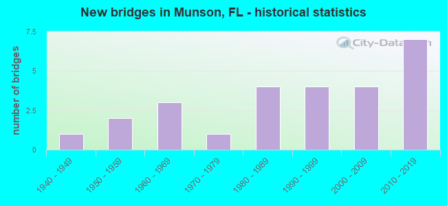
- New bridges - historical statistics
- 11940-1949
- 21950-1959
- 31960-1969
- 11970-1979
- 41980-1989
- 41990-1999
- 42000-2009
- 72010-2019


- Bridge Condition - Deck
- 8.3%Very good
- 45.8%Good
- 29.2%Satisfactory
- 16.7%Fair

- Bridge Condition - Superstructure
- 4.2%Very good
- 62.5%Good
- 20.8%Satisfactory
- 8.3%Fair
- 4.2%Poor

- Bridge Condition - Substructure
- 8.3%Very good
- 62.5%Good
- 20.8%Satisfactory
- 8.3%Fair

- Bridge Condition - Channel
- 7.7%Very good
- 34.6%Good
- 30.8%Satisfactory
- 23.1%Fair
- 3.8%Poor
Find on map >> Show street view
Structure Number: 570061, Location: 200ft E of County Line Rd (Lat: 30.850417, Lng: -86.788000), Route carried "on" structure: State highway 4, Year Built: 1947, Year Reconstructed: 1999, Status: Open, Structure Length: 0.63m (2.07ft), Average Daily Traffic: 1,650 (year 2020), Truck Traffic: 18%, Average Future Daily Traffic: 2,863 (year 2042), Design Load: HS 20, Features Intersected: Beaver Creek
Minimum Vertical Clearance: 30+ m (98+ ft), Kilometerpoint: 0.105, Lanes on structure: 2, Base Highway Network: Yes, Owner: State Highway Agency, Approaching Roadway Width: 10.4m (34.1ft), Material/Design: Concrete, Design/Construction: Culvert, Number Of Spans In Main Unit: 2, Length of Maximum Span: 3.0m (9.8ft)
Condition: Channel: Very good, Culverts: Satisfactory, Inventory Rating: 76.2 metric tons, Method Used To Determine Inventory Rating: Load Factor (LF), Structural Evaluation: Equal to present minimum criteria, Waterway Adequacy: Equal to present desirable criteria, Approach Roadway Alignment: Equal to present desirable criteria, Designated Inspection Frequency: Every 24 months, Inspection Date: November 2020
Find on map >> Show street view
Structure Number: 574071, Location: 0.7Mi W/o Beaver Crk Towr (Lat: 30.835978, Lng: -86.770286), Route carried "on" structure: State lands road , Year Built: 1984, Status: Posted for load, Structure Length: 1.01m (3.31ft), Average Daily Traffic: 50 (year 2020), Average Future Daily Traffic: 87 (year 2042), Features Intersected: Long Branch, Facility Carried by Structure: Martin Mill Road
Minimum Vertical Clearance: 30+ m (98+ ft), Kilometerpoint: 1.870, Lanes on structure: 1, Owner: State Park, Forest, or Reservation Agency, Approaching Roadway Width: 4.0m (13.1ft), Material/Design: Wood or Timber, Design/Construction: Stringer/Multi-beam, Number Of Spans In Main Unit: 3, Length of Maximum Span: 3.4m (11.2ft), Curb-To-Curb Width: 6.2m (20.3ft), Out-to-Out Width: 6.2m (20.3ft)
Condition: Deck: Fair, Superstructure: Good, Substructure: Satisfactory, Channel: Satisfactory, Operating Rating: 28.5 metric tons, Method Used To Determine Operating Rating: Allowable Stress (AS), Inventory Rating: 21.2 metric tons, Method Used To Determine Inventory Rating: Allowable Stress (AS), Structural Evaluation: Equal to present minimum criteria, Deck Geometry: Somewhat better than minimum adequacy, Waterway Adequacy: Equal to present minimum criteria, Approach Roadway Alignment: Equal to present desirable criteria, Bridge Posting: Required (Relationship of Operating Rating to Maximum Legal Load: 10.0 - 19.9% below), Designated Inspection Frequency: Every 24 months, Other Special Inspection Frequency: Every 12 months, Inspection Date: November 2021, Other Special Inspection Date: November 2021, Deck Structure Type: Wood or Timber
Find on map >> Show street view
Structure Number: 574072, Location: 0.75Mi W/o Beaver Crk Twr (Lat: 30.836444, Lng: -86.771733), Route carried "on" structure: State lands road , Year Built: 1984, Status: Posted for load, Structure Length: 2.40m (7.87ft), Average Daily Traffic: 50 (year 2020), Average Future Daily Traffic: 87 (year 2042), Features Intersected: Beaver Ck #2, Facility Carried by Structure: Martin Mill Rd
Minimum Vertical Clearance: 30+ m (98+ ft), Kilometerpoint: 1.714, Lanes on structure: 1, Owner: State Park, Forest, or Reservation Agency, Approaching Roadway Width: 4.3m (14.1ft), Material/Design: Wood or Timber, Design/Construction: Stringer/Multi-beam, Number Of Spans In Main Unit: 7, Length of Maximum Span: 3.7m (12.1ft), Curb-To-Curb Width: 5.3m (17.4ft), Out-to-Out Width: 6.2m (20.3ft)
Condition: Deck: Satisfactory, Superstructure: Poor, Substructure: Fair, Channel: Satisfactory, Operating Rating: 28.2 metric tons, Method Used To Determine Operating Rating: Allowable Stress (AS), Inventory Rating: 21.0 metric tons, Method Used To Determine Inventory Rating: Allowable Stress (AS), Structural Evaluation: Meets minimum limits, Deck Geometry: High priority of corrective action, Waterway Adequacy: Equal to present minimum criteria, Approach Roadway Alignment: Equal to present desirable criteria, Bridge Posting: Required (Relationship of Operating Rating to Maximum Legal Load: 10.0 - 19.9% below), Designated Inspection Frequency: Every 24 months, Underwater Inspection Frequency: Every 24 months, Other Special Inspection Frequency: Every 12 months, Inspection Date: November 2021, Underwater Inspection Date: November 2021, Other Special Inspection Date: November 2021, Deck Structure Type: Wood or Timber
Find on map >> Show street view
Structure Number: 580026, Location: 1 Mi South of Jean Rd (Lat: 30.898072, Lng: -86.888406), Route carried "on" structure: County highway 191, Year Built: 1952, Status: Posted for load, Structure Length: 5.35m (17.55ft), Average Daily Traffic: 400 (year 2020), Truck Traffic: 12%, Average Future Daily Traffic: 694 (year 2042), Design Load: H 10, Features Intersected: Big Juniper Creek
Minimum Vertical Clearance: 30+ m (98+ ft), Kilometerpoint: 6.127, Lanes on structure: 2, Owner: County Highway Agency, Approaching Roadway Width: 6.7m (22.0ft), Material/Design: Steel continuous, Design/Construction: Stringer/Multi-beam, Number Of Spans In Main Unit: 7, Length of Maximum Span: 7.7m (25.3ft), Curb or Sidewalk Widths: Left: 0.2m (0.7ft), Right: 0.2m (0.7ft), Curb-To-Curb Width: 7.3m (24.0ft), Out-to-Out Width: 7.8m (25.6ft)
Condition: Deck: Satisfactory, Superstructure: Good, Substructure: Good, Channel: Satisfactory, Operating Rating: 32.0 metric tons, Method Used To Determine Operating Rating: Load Factor (LF), Inventory Rating: 20.5 metric tons, Method Used To Determine Inventory Rating: Load Factor (LF), Structural Evaluation: Somewhat better than minimum adequacy, Deck Geometry: Somewhat better than minimum adequacy, Waterway Adequacy: Equal to present minimum criteria, Approach Roadway Alignment: Equal to present desirable criteria, Bridge Posting: Required (Relationship of Operating Rating to Maximum Legal Load: 30.0 - 39.9% below), Designated Inspection Frequency: Every 24 months, Underwater Inspection Frequency: Every 24 months, Other Special Inspection Frequency: Every 12 months, Inspection Date: August 2020, Underwater Inspection Date: August 2020, Other Special Inspection Date: August 2021, Deck Structure Type: Concrete Cast-file-Place
Find on map >> Show street view
Structure Number: 580027, Location: 4.2Mi NW of Belandville R (Lat: 30.917664, Lng: -86.887342), Route carried "on" structure: County highway 191, Year Built: 1952, Status: Open, Structure Length: 0.77m (2.53ft), Average Daily Traffic: 400 (year 2021), Truck Traffic: 13%, Average Future Daily Traffic: 694 (year 2042), Design Load: HS 20, Features Intersected: Unnamed Branch
Minimum Vertical Clearance: 30+ m (98+ ft), Kilometerpoint: 8.325, Lanes on structure: 2, Owner: County Highway Agency, Approaching Roadway Width: 6.7m (22.0ft), Material/Design: Concrete, Design/Construction: Culvert, Number Of Spans In Main Unit: 3, Length of Maximum Span: 2.7m (8.9ft)
Condition: Channel: Fair, Culverts: Satisfactory, Operating Rating: 53.5 metric tons, Method Used To Determine Operating Rating: Load Factor (LF), Inventory Rating: 31.8 metric tons, Method Used To Determine Inventory Rating: Load Factor (LF), Structural Evaluation: Equal to present minimum criteria, Waterway Adequacy: Equal to present minimum criteria, Approach Roadway Alignment: Equal to present desirable criteria, Designated Inspection Frequency: Every 24 months, Inspection Date: January 2021
Find on map >> Show street view
Structure Number: 580045, Location: 2.52 Mi South of SR 4 (Lat: 30.833650, Lng: -86.903375), Route carried "on" structure: County highway 191, Year Built: 1971, Status: Open, Structure Length: 6.70m (21.98ft), Average Daily Traffic: 950 (year 2020), Truck Traffic: 14%, Average Future Daily Traffic: 1,648 (year 2042), Design Load: HS 20, Features Intersected: Big Juniper Creek
Minimum Vertical Clearance: 30+ m (98+ ft), Kilometerpoint: 27.393, Lanes on structure: 2, Owner: County Highway Agency, Approaching Roadway Width: 7.3m (24.0ft), Material/Design: Prestressed concrete, Design/Construction: Stringer/Multi-beam, Number Of Spans In Main Unit: 5, Length of Maximum Span: 13.4m (44.0ft), Curb-To-Curb Width: 13.4m (44.0ft), Out-to-Out Width: 14.1m (46.3ft)
Condition: Deck: Good, Superstructure: Good, Substructure: Satisfactory, Channel: Good, Operating Rating: 59.9 metric tons, Method Used To Determine Operating Rating: Load Factor (LF), Inventory Rating: 37.2 metric tons, Method Used To Determine Inventory Rating: Load Factor (LF), Structural Evaluation: Equal to present minimum criteria, Deck Geometry: Superior to present desirable criteria, Waterway Adequacy: Equal to present desirable criteria, Approach Roadway Alignment: Equal to present desirable criteria, Designated Inspection Frequency: Every 24 months, Inspection Date: November 2020, Deck Structure Type: Concrete Cast-file-Place
Find on map >> Show street view
Structure Number: 580097, Location: 4.8mi. West of Countyline (Lat: 30.855628, Lng: -86.851433), Route carried "on" structure: State highway 4, Year Built: 1983, Status: Open, Structure Length: 11.58m (37.99ft), Average Daily Traffic: 1,800 (year 2020), Truck Traffic: 20%, Average Future Daily Traffic: 3,123 (year 2042), Design Load: HS 20, Features Intersected: Sweetwater Creek
Minimum Vertical Clearance: 30+ m (98+ ft), Kilometerpoint: 40.773, Lanes on structure: 2, Base Highway Network: Yes, Owner: State Highway Agency, Approaching Roadway Width: 10.4m (34.1ft), Material/Design: Prestressed concrete continuous, Design/Construction: Stringer/Multi-beam, Number Of Spans In Main Unit: 5, Length of Maximum Span: 23.2m (76.1ft), Curb-To-Curb Width: 13.4m (44.0ft), Out-to-Out Width: 14.3m (46.9ft)
Condition: Deck: Good, Superstructure: Good, Substructure: Good, Channel: Good, Operating Rating: 78.9 metric tons, Method Used To Determine Operating Rating: Load Factor (LF), Inventory Rating: 47.2 metric tons, Method Used To Determine Inventory Rating: Load Factor (LF), Structural Evaluation: Better than present minimum criteria, Deck Geometry: Equal to present desirable criteria, Waterway Adequacy: Equal to present desirable criteria, Approach Roadway Alignment: Equal to present desirable criteria, Designated Inspection Frequency: Every 24 months, Inspection Date: July 2020, Deck Structure Type: Concrete Cast-file-Place
Find on map >> Show street view
Structure Number: 580107, Location: 2.0 Mi. West of CR191 (Lat: 30.863128, Lng: -86.904433), Route carried "on" structure: State highway 4, Year Built: 1997, Status: Open, Structure Length: 9.60m (31.50ft), Average Daily Traffic: 1,485 (year 2020), Truck Traffic: 21%, Average Future Daily Traffic: 2,576 (year 2042), Design Load: HS 20+Mod, Features Intersected: Big Juniper Creek
Minimum Vertical Clearance: 30+ m (98+ ft), Kilometerpoint: 35.641, Lanes on structure: 2, Base Highway Network: Yes, Owner: State Highway Agency, Approaching Roadway Width: 9.8m (32.2ft), Material/Design: Prestressed concrete, Design/Construction: Stringer/Multi-beam, Number Of Spans In Main Unit: 5, Length of Maximum Span: 21.3m (69.9ft), Curb-To-Curb Width: 13.4m (44.0ft), Out-to-Out Width: 14.4m (47.2ft)
Condition: Deck: Satisfactory, Superstructure: Satisfactory, Substructure: Good, Channel: Very good, Operating Rating: 79.8 metric tons, Method Used To Determine Operating Rating: Load Factor (LF), Inventory Rating: 47.2 metric tons, Method Used To Determine Inventory Rating: Load Factor (LF), Structural Evaluation: Equal to present minimum criteria, Deck Geometry: Equal to present desirable criteria, Waterway Adequacy: Superior to present desirable criteria, Approach Roadway Alignment: Equal to present desirable criteria, Designated Inspection Frequency: Every 24 months, Inspection Date: September 2020, Deck Structure Type: Concrete Cast-file-Place
Find on map >> Show street view
Structure Number: 580157, Location: 5.0MI East of SR87 (Lat: 30.882350, Lng: -86.958317), Route carried "on" structure: State highway 4, Year Built: 1998, Status: Open, Structure Length: 13.72m (45.01ft), Average Daily Traffic: 1,485 (year 2020), Truck Traffic: 21%, Average Future Daily Traffic: 2,576 (year 2042), Design Load: HS 20, Features Intersected: East Coldwater Creek
Minimum Vertical Clearance: 30+ m (98+ ft), Kilometerpoint: 30.038, Lanes on structure: 2, Owner: State Highway Agency, Approaching Roadway Width: 10.4m (34.1ft), Material/Design: Prestressed concrete continuous, Design/Construction: Stringer/Multi-beam, Number Of Spans In Main Unit: 5, Length of Maximum Span: 27.4m (89.9ft), Curb-To-Curb Width: 13.4m (44.0ft), Out-to-Out Width: 14.4m (47.2ft)
Condition: Deck: Good, Superstructure: Good, Substructure: Good, Channel: Good, Inventory Rating: 59.9 metric tons, Method Used To Determine Inventory Rating: Load Factor (LF), Structural Evaluation: Better than present minimum criteria, Deck Geometry: Equal to present desirable criteria, Waterway Adequacy: Superior to present desirable criteria, Approach Roadway Alignment: Equal to present desirable criteria, Designated Inspection Frequency: Every 24 months, Inspection Date: March 2020, Deck Structure Type: Concrete Cast-file-Place
Find on map >> Show street view
Structure Number: 580805, Location: 0.67Mi W of Charlie Fstr (Lat: 30.818139, Lng: -86.805528), Route carried "on" structure: State lands road , Year Built: 1991, Status: Open, Structure Length: 0.70m (2.30ft), Average Daily Traffic: 50 (year 2020), Average Future Daily Traffic: 87 (year 2042), Features Intersected: Unnamed Branch, Facility Carried by Structure: Fire Line Road
Minimum Vertical Clearance: 30+ m (98+ ft), Kilometerpoint: 0.428, Lanes on structure: 1, Owner: State Park, Forest, or Reservation Agency, Approaching Roadway Width: 3.4m (11.2ft), Material/Design: Wood or Timber, Design/Construction: Stringer/Multi-beam, Number Of Spans In Main Unit: 2, Length of Maximum Span: 3.6m (11.8ft), Curb-To-Curb Width: 3.6m (11.8ft), Out-to-Out Width: 3.7m (12.1ft)
Condition: Deck: Satisfactory, Superstructure: Good, Substructure: Good, Channel: Satisfactory, Operating Rating: 33.6 metric tons, Method Used To Determine Operating Rating: Allowable Stress (AS), Inventory Rating: 24.5 metric tons, Method Used To Determine Inventory Rating: Allowable Stress (AS), Structural Evaluation: Equal to present minimum criteria, Deck Geometry: High priority of corrective action, Waterway Adequacy: Equal to present minimum criteria, Approach Roadway Alignment: Equal to present desirable criteria, Designated Inspection Frequency: Every 24 months, Inspection Date: November 2020, Deck Structure Type: Wood or Timber
Find on map >> Show street view
Structure Number: 580816, Location: Krul Recreation Area (Lat: 30.860219, Lng: -86.856400), Route carried "on" structure: State lands road , Year Built: 2001, Status: Open, Structure Length: 2.30m (7.55ft), Average Daily Traffic: 250 (year 2020), Average Future Daily Traffic: 434 (year 2042), Design Load: HS 20, Features Intersected: Munson Gorge, Facility Carried by Structure: Krul Lake Road
Minimum Vertical Clearance: 30+ m (98+ ft), Kilometerpoint: 0.707, Lanes on structure: 2, Owner: State Park, Forest, or Reservation Agency, Approaching Roadway Width: 6.1m (20.0ft), Material/Design: Steel continuous, Design/Construction: Stringer/Multi-beam, Number Of Spans In Main Unit: 3, Length of Maximum Span: 7.8m (25.6ft), Curb-To-Curb Width: 7.1m (23.3ft), Out-to-Out Width: 7.3m (24.0ft)
Condition: Deck: Good, Superstructure: Satisfactory, Substructure: Good, Channel: Fair, Operating Rating: 60.8 metric tons, Method Used To Determine Operating Rating: Load Factor (LF), Inventory Rating: 36.5 metric tons, Method Used To Determine Inventory Rating: Load Factor (LF), Structural Evaluation: Equal to present minimum criteria, Deck Geometry: Meets minimum limits, Waterway Adequacy: Better than present minimum criteria, Approach Roadway Alignment: Equal to present desirable criteria, Designated Inspection Frequency: Every 24 months, Inspection Date: June 2021, Deck Structure Type: Wood or Timber, Wearing Surface/Protective System: Wearing Surface: Bituminous
Find on map >> Show street view
Structure Number: 580822, Location: 1 Mi East of CR191 (Lat: 30.931889, Lng: -86.870333), Route carried "on" structure: State lands road , Year Built: 2011, Status: Open, Structure Length: 1.83m (6.00ft), Average Daily Traffic: 150 (year 2020), Average Future Daily Traffic: 260 (year 2042), Design Load: HL 93, Features Intersected: Juniper Creek #1, Facility Carried by Structure: Carpenter Road
Minimum Vertical Clearance: 30+ m (98+ ft), Kilometerpoint: 1.601, Lanes on structure: 1, Owner: State Park, Forest, or Reservation Agency, Approaching Roadway Width: 6.4m (21.0ft), Material/Design: Steel continuous, Design/Construction: Stringer/Multi-beam, Number Of Spans In Main Unit: 2, Length of Maximum Span: 9.1m (29.9ft), Curb-To-Curb Width: 6.4m (21.0ft), Out-to-Out Width: 6.4m (21.0ft)
Condition: Deck: Satisfactory, Superstructure: Fair, Substructure: Very good, Channel: Fair, Operating Rating: 35.4 metric tons, Method Used To Determine Operating Rating: Load and Resistance Factor (LRFR), Inventory Rating: 27.2 metric tons, Method Used To Determine Inventory Rating: Load and Resistance Factor (LRFR), Structural Evaluation: Somewhat better than minimum adequacy, Deck Geometry: Meets minimum limits, Waterway Adequacy: Equal to present desirable criteria, Approach Roadway Alignment: Equal to present desirable criteria, Designated Inspection Frequency: Every 24 months, Underwater Inspection Frequency: Every 24 months, Inspection Date: October 2021, Underwater Inspection Date: October 2021, Deck Structure Type: Open Grating
Find on map >> Show street view
Structure Number: 580825, Location: 1.06 Mi S of CR 191 (Lat: 30.837222, Lng: -86.871111), Route carried "on" structure: State lands road , Year Built: 2016, Status: Open, Structure Length: 3.66m (12.01ft), Average Daily Traffic: 100 (year 2020), Average Future Daily Traffic: 174 (year 2042), Design Load: HL 93, Features Intersected: Sweet Water # 1, Facility Carried by Structure: Sandy Forest Road
Minimum Vertical Clearance: 30+ m (98+ ft), Kilometerpoint: 30.679, Lanes on structure: 2, Owner: State Park, Forest, or Reservation Agency, Approaching Roadway Width: 7.5m (24.6ft), Material/Design: Concrete, Design/Construction: Channel Beam, Number Of Spans In Main Unit: 3, Length of Maximum Span: 12.2m (40.0ft), Curb-To-Curb Width: 7.5m (24.6ft), Out-to-Out Width: 8.3m (27.2ft)
Condition: Deck: Good, Superstructure: Good, Substructure: Very good, Channel: Satisfactory, Operating Rating: 46.5 metric tons, Method Used To Determine Operating Rating: Load and Resistance Factor (LRFR), Inventory Rating: 35.9 metric tons, Method Used To Determine Inventory Rating: Load and Resistance Factor (LRFR), Structural Evaluation: Better than present minimum criteria, Deck Geometry: Equal to present minimum criteria, Waterway Adequacy: Equal to present desirable criteria, Approach Roadway Alignment: Equal to present desirable criteria, Designated Inspection Frequency: Every 24 months, Underwater Inspection Frequency: Every 24 months, Inspection Date: June 2020, Underwater Inspection Date: June 2020, Deck Structure Type: Concrete Precast Panels
Find on map >> Show street view
Structure Number: 580826, Location: 0.3 Mi South of SR 4 (Lat: 30.861972, Lng: -86.910444), Route carried "on" structure: State lands road , Year Built: 2016, Status: Open, Structure Length: 0.91m (2.99ft), Average Daily Traffic: 25 (year 2020), Truck Traffic: 1%, Average Future Daily Traffic: 43 (year 2042), Design Load: HL 93, Features Intersected: Hog Pen Branch, Facility Carried by Structure: Al Rice Road
Minimum Vertical Clearance: 30+ m (98+ ft), Kilometerpoint: 0.261, Lanes on structure: 1, Owner: State Park, Forest, or Reservation Agency, Approaching Roadway Width: 6.1m (20.0ft), Material/Design: Steel, Design/Construction: Stringer/Multi-beam, Number Of Spans In Main Unit: 1, Length of Maximum Span: 9.1m (29.9ft), Curb-To-Curb Width: 4.9m (16.1ft), Out-to-Out Width: 5.2m (17.1ft)
Condition: Deck: Satisfactory, Superstructure: Satisfactory, Substructure: Good, Channel: Good, Operating Rating: 45.6 metric tons, Method Used To Determine Operating Rating: Load and Resistance Factor (LRFR), Inventory Rating: 35.2 metric tons, Method Used To Determine Inventory Rating: Load and Resistance Factor (LRFR), Structural Evaluation: Equal to present minimum criteria, Deck Geometry: High priority of corrective action, Waterway Adequacy: Equal to present minimum criteria, Approach Roadway Alignment: Equal to present desirable criteria, Designated Inspection Frequency: Every 24 months, Inspection Date: October 2020, Deck Structure Type: Open Grating
Find on map >> Show street view
Structure Number: 584059, Location: 1.6 Mi W of Munson Hwy (Lat: 30.916639, Lng: -86.910606), Route carried "on" structure: State lands road , Year Built: 1960, Status: Posted for load, Structure Length: 0.83m (2.72ft), Average Daily Traffic: 50 (year 2020), Average Future Daily Traffic: 87 (year 2042), Design Load: HS 20, Features Intersected: Turkey Creek #2, Facility Carried by Structure: Reed Lake Road
Minimum Vertical Clearance: 30+ m (98+ ft), Kilometerpoint: 1.590, Lanes on structure: 1, Owner: State Park, Forest, or Reservation Agency, Approaching Roadway Width: 3.7m (12.1ft), Material/Design: Wood or Timber, Design/Construction: Stringer/Multi-beam, Number Of Spans In Main Unit: 2, Length of Maximum Span: 4.9m (16.1ft), Curb-To-Curb Width: 6.2m (20.3ft), Out-to-Out Width: 6.2m (20.3ft)
Condition: Deck: Good, Superstructure: Satisfactory, Substructure: Satisfactory, Channel: Poor, Operating Rating: 21.8 metric tons, Method Used To Determine Operating Rating: Allowable Stress (AS), Inventory Rating: 15.4 metric tons, Method Used To Determine Inventory Rating: Allowable Stress (AS), Structural Evaluation: Meets minimum limits, Deck Geometry: Somewhat better than minimum adequacy, Waterway Adequacy: Equal to present minimum criteria, Approach Roadway Alignment: Equal to present desirable criteria, Bridge Posting: Required (Relationship of Operating Rating to Maximum Legal Load: > 39.9% below), Designated Inspection Frequency: Every 24 months, Underwater Inspection Frequency: Every 12 months, Other Special Inspection Frequency: Every 12 months, Inspection Date: December 2021, Underwater Inspection Date: December 2021, Other Special Inspection Date: December 2021, Deck Structure Type: Wood or Timber
Find on map >> Show street view
Structure Number: 584065, Location: 2.1 Mi NE of CR 191 (Lat: 30.898561, Lng: -86.823878), Route carried "on" structure: County highway , Year Built: 1960, Status: Posted for load, Structure Length: 3.47m (11.38ft), Average Daily Traffic: 75 (year 2022), Average Future Daily Traffic: 130 (year 2042), Features Intersected: Sweetwater Creek, Facility Carried by Structure: Green Road
Minimum Vertical Clearance: 30+ m (98+ ft), Kilometerpoint: 4.060, Lanes on structure: 2, Owner: County Highway Agency, Approaching Roadway Width: 5.5m (18.0ft), Material/Design: Wood or Timber, Design/Construction: Stringer/Multi-beam, Number Of Spans In Main Unit: 9, Length of Maximum Span: 4.3m (14.1ft), Curb or Sidewalk Widths: Left: 0.2m (0.7ft), Right: 0.2m (0.7ft), Curb-To-Curb Width: 5.7m (18.7ft), Out-to-Out Width: 6.2m (20.3ft)
Condition: Deck: Fair, Superstructure: Good, Substructure: Good, Channel: Satisfactory, Operating Rating: 26.1 metric tons, Method Used To Determine Operating Rating: Allowable Stress (AS), Inventory Rating: 19.2 metric tons, Method Used To Determine Inventory Rating: Allowable Stress (AS), Structural Evaluation: Somewhat better than minimum adequacy, Deck Geometry: Meets minimum limits, Waterway Adequacy: Better than present minimum criteria, Approach Roadway Alignment: Equal to present desirable criteria, Bridge Posting: Required (Relationship of Operating Rating to Maximum Legal Load: 20.0 - 29.9% below), Designated Inspection Frequency: Every 24 months, Other Special Inspection Frequency: Every 12 months, Inspection Date: Febuary 2022, Other Special Inspection Date: Febuary 2022, Deck Structure Type: Wood or Timber
Find on map >> Show street view
Structure Number: 584067, Location: 1.47 Mi W of Beaver Crk R (Lat: 30.938189, Lng: -86.802742), Route carried "on" structure: State lands road , Year Built: 1960, Status: Open, Structure Length: 1.38m (4.53ft), Average Daily Traffic: 75 (year 2020), Average Future Daily Traffic: 130 (year 2042), Design Load: HS 20, Features Intersected: Sweetwater Creek, Facility Carried by Structure: Old Bullard Road
Minimum Vertical Clearance: 30+ m (98+ ft), Kilometerpoint: 4.031, Lanes on structure: 1, Owner: State Park, Forest, or Reservation Agency, Approaching Roadway Width: 4.3m (14.1ft), Material/Design: Steel continuous, Design/Construction: Stringer/Multi-beam, Number Of Spans In Main Unit: 2, Length of Maximum Span: 9.2m (30.2ft), Curb or Sidewalk Widths: Left: 0.2m (0.7ft), Right: 0.2m (0.7ft), Curb-To-Curb Width: 3.1m (10.2ft), Out-to-Out Width: 3.2m (10.5ft)
Condition: Deck: Fair, Superstructure: Fair, Substructure: Fair, Channel: Fair, Inventory Rating: 61.7 metric tons, Method Used To Determine Inventory Rating: Load Factor (LF), Structural Evaluation: Somewhat better than minimum adequacy, Deck Geometry: High priority of replacement, Waterway Adequacy: Equal to present desirable criteria, Approach Roadway Alignment: Equal to present desirable criteria, Designated Inspection Frequency: Every 24 months, Underwater Inspection Frequency: Every 24 months, Inspection Date: March 2020, Underwater Inspection Date: March 2020, Deck Structure Type: Open Grating
Find on map >> Show street view
Structure Number: 584128, Location: 0.9 Mi W of CR 191 (Lat: 30.875253, Lng: -86.901511), Route carried "on" structure: County highway , Year Built: 1988, Status: Open, Structure Length: 2.34m (7.68ft), Average Daily Traffic: 150 (year 2021), Average Future Daily Traffic: 260 (year 2042), Design Load: HS 20, Features Intersected: Big Juniper Creek, Facility Carried by Structure: Amos Cabaniss Road
Minimum Vertical Clearance: 30+ m (98+ ft), Kilometerpoint: 1.875, Lanes on structure: 2, Owner: County Highway Agency, Approaching Roadway Width: 6.1m (20.0ft), Material/Design: Wood or Timber, Design/Construction: Stringer/Multi-beam, Number Of Spans In Main Unit: 7, Length of Maximum Span: 3.5m (11.5ft), Curb or Sidewalk Widths: Left: 0.2m (0.7ft), Right: 0.2m (0.7ft), Curb-To-Curb Width: 5.7m (18.7ft), Out-to-Out Width: 6.2m (20.3ft)
Condition: Deck: Good, Superstructure: Good, Substructure: Good, Channel: Satisfactory, Operating Rating: 37.2 metric tons, Method Used To Determine Operating Rating: Allowable Stress (AS), Inventory Rating: 28.1 metric tons, Method Used To Determine Inventory Rating: Allowable Stress (AS), Structural Evaluation: Better than present minimum criteria, Deck Geometry: High priority of corrective action, Waterway Adequacy: Equal to present minimum criteria, Approach Roadway Alignment: Equal to present desirable criteria, Designated Inspection Frequency: Every 24 months, Underwater Inspection Frequency: Every 24 months, Inspection Date: October 2021, Underwater Inspection Date: October 2021, Deck Structure Type: Wood or Timber
Find on map >> Show street view
Structure Number: 584172, Location: 2 Mi E of Belandville Rd (Lat: 30.892878, Lng: -86.837225), Route carried "on" structure: County highway , Year Built: 1997, Status: Open, Structure Length: 1.52m (4.99ft), Average Daily Traffic: 100 (year 2020), Average Future Daily Traffic: 174 (year 2042), Features Intersected: Cedar Creek, Facility Carried by Structure: Green Road
Minimum Vertical Clearance: 30+ m (98+ ft), Kilometerpoint: 2.519, Lanes on structure: 2, Owner: County Highway Agency, Approaching Roadway Width: 6.4m (21.0ft), Material/Design: Wood or Timber, Design/Construction: Stringer/Multi-beam, Number Of Spans In Main Unit: 5, Length of Maximum Span: 3.1m (10.2ft), Curb or Sidewalk Widths: Left: 0.1m (0.3ft), Right: 0.1m (0.3ft), Curb-To-Curb Width: 7.0m (23.0ft), Out-to-Out Width: 7.3m (24.0ft)
Condition: Deck: Fair, Superstructure: Very good, Substructure: Good, Channel: Fair, Operating Rating: 34.5 metric tons, Method Used To Determine Operating Rating: Allowable Stress (AS), Inventory Rating: 25.4 metric tons, Method Used To Determine Inventory Rating: Allowable Stress (AS), Structural Evaluation: Equal to present minimum criteria, Deck Geometry: Somewhat better than minimum adequacy, Waterway Adequacy: Equal to present minimum criteria, Approach Roadway Alignment: Equal to present minimum criteria, Designated Inspection Frequency: Every 24 months, Underwater Inspection Frequency: Every 24 months, Inspection Date: November 2020, Underwater Inspection Date: November 2020, Deck Structure Type: Wood or Timber
Find on map >> Show street view
Structure Number: 584182, Location: 0.58 Mi S of SR 4 (Lat: 30.846472, Lng: -86.838389), Route carried "on" structure: County highway , Year Built: 2001, Status: Open, Structure Length: 1.26m (4.13ft), Average Daily Traffic: 50 (year 2021), Average Future Daily Traffic: 87 (year 2042), Design Load: HS 20, Features Intersected: Blue Creek, Facility Carried by Structure: Red Morris Road
Minimum Vertical Clearance: 30+ m (98+ ft), Kilometerpoint: 0.550, Lanes on structure: 2, Owner: County Highway Agency, Approaching Roadway Width: 5.5m (18.0ft), Material/Design: Wood or Timber, Design/Construction: Stringer/Multi-beam, Number Of Spans In Main Unit: 4, Length of Maximum Span: 3.3m (10.8ft), Curb or Sidewalk Widths: Left: 0.1m (0.3ft), Right: 0.1m (0.3ft), Curb-To-Curb Width: 7.0m (23.0ft), Out-to-Out Width: 7.3m (24.0ft)
Condition: Deck: Good, Superstructure: Good, Substructure: Good, Channel: Satisfactory, Operating Rating: 28.4 metric tons, Method Used To Determine Operating Rating: Load and Resistance Factor (LRFR), Inventory Rating: 21.9 metric tons, Method Used To Determine Inventory Rating: Load and Resistance Factor (LRFR), Structural Evaluation: Equal to present minimum criteria, Deck Geometry: Somewhat better than minimum adequacy, Waterway Adequacy: Better than present minimum criteria, Approach Roadway Alignment: Equal to present minimum criteria, Designated Inspection Frequency: Every 24 months, Underwater Inspection Frequency: Every 24 months, Inspection Date: May 2021, Underwater Inspection Date: May 2021, Deck Structure Type: Wood or Timber
Find on map >> Show street view
Structure Number: 584192, Location: 1.28 Mi N of Morning Mist (Lat: 30.778225, Lng: -86.874239), Route carried "on" structure: County highway , Year Built: 2004, Status: Open, Structure Length: 2.30m (7.55ft), Average Daily Traffic: 75 (year 2020), Average Future Daily Traffic: 130 (year 2042), Design Load: HS 20, Features Intersected: Alligator Creek, Facility Carried by Structure: Bryant Bridge Road
Minimum Vertical Clearance: 30+ m (98+ ft), Kilometerpoint: 7.297, Lanes on structure: 2, Owner: County Highway Agency, Approaching Roadway Width: 6.4m (21.0ft), Material/Design: Steel, Design/Construction: Stringer/Multi-beam, Number Of Spans In Main Unit: 3, Length of Maximum Span: 7.7m (25.3ft), Curb or Sidewalk Widths: Left: 0.1m (0.3ft), Right: 0.1m (0.3ft), Curb-To-Curb Width: 7.0m (23.0ft), Out-to-Out Width: 7.3m (24.0ft)
Condition: Deck: Good, Superstructure: Good, Substructure: Good, Channel: Good, Operating Rating: 87.1 metric tons, Method Used To Determine Operating Rating: Load Factor (LF), Inventory Rating: 51.7 metric tons, Method Used To Determine Inventory Rating: Load Factor (LF), Structural Evaluation: Better than present minimum criteria, Deck Geometry: Somewhat better than minimum adequacy, Waterway Adequacy: Better than present minimum criteria, Approach Roadway Alignment: Equal to present desirable criteria, Designated Inspection Frequency: Every 24 months, Underwater Inspection Frequency: Every 24 months, Inspection Date: March 2020, Underwater Inspection Date: March 2020, Deck Structure Type: Concrete Cast-file-Place
Find on map >> Show street view
Structure Number: 584211, Location: 0.55 Mi N of CR 4 (Lat: 30.858778, Lng: -86.805375), Route carried "on" structure: County highway , Year Built: 2009, Status: Open, Structure Length: 0.76m (2.49ft), Average Daily Traffic: 100 (year 2021), Average Future Daily Traffic: 174 (year 2042), Design Load: HS 20, Features Intersected: Unnamed Branch, Facility Carried by Structure: Old Martin Road
Minimum Vertical Clearance: 30+ m (98+ ft), Kilometerpoint: 0.863, Lanes on structure: 2, Owner: County Highway Agency, Approaching Roadway Width: 7.0m (23.0ft), Material/Design: Steel, Design/Construction: Stringer/Multi-beam, Number Of Spans In Main Unit: 1, Length of Maximum Span: 7.6m (24.9ft), Curb or Sidewalk Widths: Left: 0.1m (0.3ft), Right: 0.1m (0.3ft), Curb-To-Curb Width: 7.0m (23.0ft), Out-to-Out Width: 7.3m (24.0ft)
Condition: Deck: Very good, Superstructure: Good, Substructure: Satisfactory, Channel: Fair, Inventory Rating: 58.1 metric tons, Method Used To Determine Inventory Rating: Load Factor (LF), Structural Evaluation: Equal to present minimum criteria, Deck Geometry: Somewhat better than minimum adequacy, Waterway Adequacy: Better than present minimum criteria, Approach Roadway Alignment: Equal to present desirable criteria, Designated Inspection Frequency: Every 24 months, Inspection Date: June 2021, Deck Structure Type: Concrete Cast-file-Place
Find on map >> Show street view
Structure Number: 584214, Location: 0.6 Mi South of Hwy 4 (Lat: 30.846194, Lng: -86.838444), Route carried "on" structure: County highway , Year Built: 2010, Status: Open, Structure Length: 1.12m (3.67ft), Average Daily Traffic: 20 (year 2020), Average Future Daily Traffic: 35 (year 2042), Design Load: HS 20, Features Intersected: Blue Creek Relief, Facility Carried by Structure: Red Morris Road
Minimum Vertical Clearance: 30+ m (98+ ft), Kilometerpoint: 0.517, Lanes on structure: 2, Owner: County Highway Agency, Approaching Roadway Width: 6.9m (22.6ft), Material/Design: Steel, Design/Construction: Stringer/Multi-beam, Number Of Spans In Main Unit: 1, Length of Maximum Span: 11.2m (36.7ft), Curb or Sidewalk Widths: Left: 0.1m (0.3ft), Right: 0.1m (0.3ft), Curb-To-Curb Width: 7.1m (23.3ft), Out-to-Out Width: 7.4m (24.3ft)
Condition: Deck: Satisfactory, Superstructure: Satisfactory, Substructure: Good, Channel: Good, Operating Rating: 49.0 metric tons, Method Used To Determine Operating Rating: Load Factor (LF), Inventory Rating: 29.0 metric tons, Method Used To Determine Inventory Rating: Load Factor (LF), Structural Evaluation: Equal to present minimum criteria, Deck Geometry: Somewhat better than minimum adequacy, Waterway Adequacy: Meets minimum limits, Approach Roadway Alignment: Equal to present desirable criteria, Designated Inspection Frequency: Every 24 months, Inspection Date: September 2020, Deck Structure Type: Concrete Cast-file-Place
Find on map >> Show street view
Structure Number: 584216, Location: 3.2 Mi East of CR 191 (Lat: 30.784889, Lng: -86.893667), Route carried "on" structure: County highway , Year Built: 2012, Status: Open, Structure Length: 1.55m (5.09ft), Average Daily Traffic: 75 (year 2021), Average Future Daily Traffic: 130 (year 2042), Design Load: HL 93, Features Intersected: Ellis Creek, Facility Carried by Structure: Red Rock Road
Minimum Vertical Clearance: 30.18m (99.02ft), Kilometerpoint: 5.071, Lanes on structure: 2, Owner: County Highway Agency, Approaching Roadway Width: 5.8m (19.0ft), Material/Design: Steel continuous, Design/Construction: Stringer/Multi-beam, Number Of Spans In Main Unit: 2, Length of Maximum Span: 7.8m (25.6ft), Curb-To-Curb Width: 7.2m (23.6ft), Out-to-Out Width: 7.4m (24.3ft)
Condition: Deck: Very good, Superstructure: Good, Substructure: Good, Channel: Good, Operating Rating: 77.1 metric tons, Method Used To Determine Operating Rating: Load and Resistance Factor (LRFR), Inventory Rating: 59.0 metric tons, Method Used To Determine Inventory Rating: Load and Resistance Factor (LRFR), Structural Evaluation: Better than present minimum criteria, Deck Geometry: Somewhat better than minimum adequacy, Waterway Adequacy: Somewhat better than minimum adequacy, Approach Roadway Alignment: Equal to present desirable criteria, Designated Inspection Frequency: Every 24 months, Inspection Date: December 2021, Deck Structure Type: Concrete Cast-file-Place
Find on map >> Show street view
Structure Number: 584217, Location: 3.3 Mi East of CR 191 (Lat: 30.785278, Lng: -86.891111), Route carried "on" structure: County highway , Year Built: 2012, Status: Open, Structure Length: 3.08m (10.10ft), Average Daily Traffic: 75 (year 2021), Average Future Daily Traffic: 130 (year 2042), Design Load: HL 93, Features Intersected: Big Juniper Creek, Facility Carried by Structure: Red Rock Road
Minimum Vertical Clearance: 30+ m (98+ ft), Kilometerpoint: 5.301, Lanes on structure: 2, Owner: County Highway Agency, Approaching Roadway Width: 5.8m (19.0ft), Material/Design: Steel continuous, Design/Construction: Stringer/Multi-beam, Number Of Spans In Main Unit: 5, Length of Maximum Span: 7.8m (25.6ft), Curb-To-Curb Width: 7.2m (23.6ft), Out-to-Out Width: 7.4m (24.3ft)
Condition: Deck: Good, Superstructure: Good, Substructure: Satisfactory, Channel: Good, Operating Rating: 58.1 metric tons, Method Used To Determine Operating Rating: Load and Resistance Factor (LRFR), Inventory Rating: 44.5 metric tons, Method Used To Determine Inventory Rating: Load and Resistance Factor (LRFR), Structural Evaluation: Equal to present minimum criteria, Deck Geometry: Somewhat better than minimum adequacy, Waterway Adequacy: Somewhat better than minimum adequacy, Approach Roadway Alignment: Equal to present desirable criteria, Designated Inspection Frequency: Every 24 months, Underwater Inspection Frequency: Every 24 months, Inspection Date: December 2021, Underwater Inspection Date: December 2021, Deck Structure Type: Concrete Precast Panels
Find on map >> Show street view
Structure Number: 584237, Location: 0.9 Mi North of CR4 (Lat: 30.875750, Lng: -86.905528), Route carried "on" structure: County highway , Year Built: 2018, Status: Open, Structure Length: 1.52m (4.99ft), Average Daily Traffic: 100 (year 2021), Average Future Daily Traffic: 174 (year 2042), Features Intersected: Turkey Creek, Facility Carried by Structure: Amos Cabaniss Road
Minimum Vertical Clearance: 30+ m (98+ ft), Kilometerpoint: 1.485, Lanes on structure: 2, Owner: County Highway Agency, Approaching Roadway Width: 6.7m (22.0ft), Material/Design: Steel, Design/Construction: Stringer/Multi-beam, Number Of Spans In Main Unit: 2, Length of Maximum Span: 7.6m (24.9ft), Curb-To-Curb Width: 7.2m (23.6ft), Out-to-Out Width: 7.3m (24.0ft)
Condition: Deck: Good, Superstructure: Good, Substructure: Good, Channel: Good, Inventory Rating: 80.3 metric tons, Method Used To Determine Inventory Rating: Load and Resistance Factor (LRFR), Structural Evaluation: Better than present minimum criteria, Deck Geometry: Somewhat better than minimum adequacy, Waterway Adequacy: Better than present minimum criteria, Approach Roadway Alignment: Equal to present minimum criteria, Designated Inspection Frequency: Every 24 months, Inspection Date: Febuary 2021, Deck Structure Type: Concrete Precast Panels