Bridge Statistics for Mullens, West Virginia (WV)
Condition, Traffic, Stress, Structural Evaluation, Project Costs
- National Bridge Inventory (NBI) Statistics
- 18Number of bridges
- 177ft / 53.9mTotal length
- $15,850,000Total costs
- 34,640Total average daily traffic
- 3,383Total average daily truck traffic
- National Bridge Inventory (NBI) Registered Bridges for Mullens
- No street view available for this location
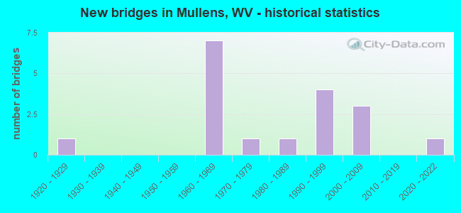
- New bridges - historical statistics
- 11920-1929
- 71960-1969
- 11970-1979
- 11980-1989
- 41990-1999
- 32000-2009
- 12020-2022


- Bridge Condition - Deck
- 12.5%Good
- 12.5%Satisfactory
- 43.8%Fair
- 31.3%Poor

- Bridge Condition - Superstructure
- 12.5%Good
- 18.8%Satisfactory
- 37.5%Fair
- 25.0%Poor
- 6.3%Serious

- Bridge Condition - Substructure
- 6.3%Good
- 31.3%Satisfactory
- 25.0%Fair
- 37.5%Poor

- Bridge Condition - Channel
- 13.3%Excellent
- 20.0%Very good
- 60.0%Good
- 6.7%Satisfactory
Find on map >> Show street view
Structure Number: 55A067, Location: 0.16 MI S OF WV 54 (Lat: 37.581789, Lng: -81.381789), Route carried "on" structure: State highway 1600, Year Built: 1985, Status: Open, Structure Length: 4.11m (13.48ft), Average Daily Traffic: 5,700 (year 2018), Truck Traffic: 10%, Average Future Daily Traffic: 6,327 (year 2038), Design Load: HS 20, Features Intersected: SLAB FORK, Facility Carried by Structure: WV 16
Minimum Vertical Clearance: 30+ m (98+ ft), Kilometerpoint: 39.847, Lanes on structure: 2, Owner: State Highway Agency, Approaching Roadway Width: 5.5m (18.0ft), Skew: 4 degrees, Material/Design: Steel, Design/Construction: Stringer/Multi-beam, Number Of Spans In Main Unit: 1, Length of Maximum Span: 38.4m (126.0ft), Curb or Sidewalk Widths: Left: 1.5m (4.9ft), Right: 1.5m (4.9ft), Curb-To-Curb Width: 10.7m (35.1ft), Out-to-Out Width: 14.4m (47.2ft)
Condition: Deck: Satisfactory, Superstructure: Satisfactory, Substructure: Poor, Channel: Good, Operating Rating: 88.9 metric tons, Method Used To Determine Operating Rating: Load Factor (LF), Inventory Rating: 72.6 metric tons, Method Used To Determine Inventory Rating: Load Factor (LF), Structural Evaluation: Meets minimum limits, Deck Geometry: Meets minimum limits, Waterway Adequacy: Equal to present minimum criteria, Approach Roadway Alignment: Meets minimum limits, Designated Inspection Frequency: Every 24 months, Inspection Date: April 2020, Deck Structure Type: Concrete Cast-file-Place, Wearing Surface/Protective System: Wearing Surface: Monolithic Concrete, Deck Protection: Epoxy Coated Reinforcing
Find on map >> Show street view
Structure Number: 55A084, Location: 0.04 MI. N. OF CR 54/4 (Lat: 37.594111, Lng: -81.378039), Route carried "on" structure: State highway 5400, Year Built: 1965, Status: Open, Structure Length: 2.24m (7.35ft), Average Daily Traffic: 2,800 (year 2018), Truck Traffic: 10%, Average Future Daily Traffic: 3,108 (year 2038), Design Load: HS 20, Features Intersected: SLAB FORK, Facility Carried by Structure: WV. 54
Minimum Vertical Clearance: 30+ m (98+ ft), Kilometerpoint: 1.609, Lanes on structure: 2, Owner: State Highway Agency, Approaching Roadway Width: 13.4m (44.0ft), Skew: 1 degrees, Material/Design: Steel, Design/Construction: Stringer/Multi-beam, Number Of Spans In Main Unit: 1, Length of Maximum Span: 21.3m (69.9ft), Curb or Sidewalk Widths: Left: 0.7m (2.3ft), Right: 0.7m (2.3ft), Curb-To-Curb Width: 8.5m (27.9ft), Out-to-Out Width: 10.7m (35.1ft)
Condition: Deck: Poor, Superstructure: Poor, Substructure: Fair, Channel: Very good, Operating Rating: 53.5 metric tons, Method Used To Determine Operating Rating: Load Factor (LF), Inventory Rating: 31.7 metric tons, Method Used To Determine Inventory Rating: Load Factor (LF), Structural Evaluation: Meets minimum limits, Deck Geometry: Meets minimum limits, Waterway Adequacy: Equal to present minimum criteria, Approach Roadway Alignment: Better than present minimum criteria, Designated Inspection Frequency: Every 24 months, Inspection Date: Febuary 2020, Deck Structure Type: Concrete Cast-file-Place, Wearing Surface/Protective System: Wearing Surface: Bituminous
Find on map >> Show street view
Structure Number: 55A085, Location: 0.03 MI S OF CR 54/4 (Lat: 37.595361, Lng: -81.379800), Route carried "on" structure: State highway 5400, Year Built: 1965, Status: Open, Structure Length: 2.87m (9.42ft), Average Daily Traffic: 2,800 (year 2019), Truck Traffic: 9%, Average Future Daily Traffic: 3,080 (year 2039), Design Load: HS 20, Features Intersected: SLAB FORK, Facility Carried by Structure: WV 54
Minimum Vertical Clearance: 30+ m (98+ ft), Kilometerpoint: 1.819, Lanes on structure: 2, Owner: State Highway Agency, Approaching Roadway Width: 13.4m (44.0ft), Skew: 2 degrees, Material/Design: Steel, Design/Construction: Stringer/Multi-beam, Number Of Spans In Main Unit: 1, Length of Maximum Span: 27.4m (89.9ft), Curb or Sidewalk Widths: Left: 0.7m (2.3ft), Right: 0.7m (2.3ft), Curb-To-Curb Width: 8.5m (27.9ft), Out-to-Out Width: 10.7m (35.1ft)
Condition: Deck: Fair, Superstructure: Poor, Substructure: Poor, Channel: Good, Operating Rating: 63.5 metric tons, Method Used To Determine Operating Rating: Load Factor (LF), Inventory Rating: 38.1 metric tons, Method Used To Determine Inventory Rating: Load Factor (LF), Structural Evaluation: Meets minimum limits, Deck Geometry: Meets minimum limits, Waterway Adequacy: Equal to present minimum criteria, Approach Roadway Alignment: Equal to present desirable criteria, Length Of Structure Improvement: 2.87m (9.42ft), Designated Inspection Frequency: Every 24 months, Inspection Date: May 2021, Bridge Improvement Cost: $200,000, Roadway Improvement Cost: $50,000, Total Project Cost: $250,000 ( Estimate for 2021), Deck Structure Type: Concrete Cast-file-Place, Wearing Surface/Protective System: Wearing Surface: Bituminous
Find on map >> Show street view
Structure Number: 55A086, Location: 0.09 MI. N. OF CR. 54/4 (Lat: 37.596511, Lng: -81.381381), Route carried "on" structure: State highway 5400, Year Built: 1965, Status: Posted for load, Structure Length: 2.91m (9.55ft), Average Daily Traffic: 2,800 (year 2018), Truck Traffic: 10%, Average Future Daily Traffic: 3,108 (year 2038), Design Load: HS 20, Features Intersected: SLAB FORK, Facility Carried by Structure: WV 54
Minimum Vertical Clearance: 30+ m (98+ ft), Kilometerpoint: 2.012, Lanes on structure: 2, Owner: State Highway Agency, Approaching Roadway Width: 13.4m (44.0ft), Skew: 4 degrees, Material/Design: Steel, Design/Construction: Stringer/Multi-beam, Number Of Spans In Main Unit: 1, Length of Maximum Span: 27.3m (89.6ft), Curb or Sidewalk Widths: Left: 0.8m (2.6ft), Right: 0.8m (2.6ft), Curb-To-Curb Width: 8.5m (27.9ft), Out-to-Out Width: 10.7m (35.1ft)
Condition: Deck: Fair, Superstructure: Fair, Substructure: Poor, Channel: Very good, Operating Rating: 46.3 metric tons, Method Used To Determine Operating Rating: Load Factor (LF), Inventory Rating: 28.1 metric tons, Method Used To Determine Inventory Rating: Load Factor (LF), Structural Evaluation: Meets minimum limits, Deck Geometry: Meets minimum limits, Waterway Adequacy: Equal to present minimum criteria, Approach Roadway Alignment: Equal to present minimum criteria, Length Of Structure Improvement: 2.91m (9.55ft), Designated Inspection Frequency: Every 24 months, Inspection Date: March 2020, Bridge Improvement Cost: $1,750,000, Roadway Improvement Cost: $250,000, Total Project Cost: $2,000,000 ( Estimate for 2020), Deck Structure Type: Concrete Cast-file-Place, Wearing Surface/Protective System: Wearing Surface: Bituminous
Find on map >> Show street view
Structure Number: 55A087, Location: 0.09 MI. S. OF CR 54/6 (Lat: 37.599211, Lng: -81.381169), Route carried "on" structure: State highway 5400, Year Built: 1965, Status: Posted for load, Structure Length: 3.04m (9.97ft), Average Daily Traffic: 2,800 (year 2018), Truck Traffic: 10%, Average Future Daily Traffic: 3,108 (year 2038), Design Load: HS 20, Features Intersected: SLAB FORK, Facility Carried by Structure: WV ROUTE 54
Minimum Vertical Clearance: 30+ m (98+ ft), Kilometerpoint: 2.317, Lanes on structure: 2, Owner: State Highway Agency, Approaching Roadway Width: 12.2m (40.0ft), Skew: 4 degrees, Material/Design: Steel, Design/Construction: Stringer/Multi-beam, Number Of Spans In Main Unit: 1, Length of Maximum Span: 28.6m (93.8ft), Curb or Sidewalk Widths: Left: 0.7m (2.3ft), Right: 0.7m (2.3ft), Curb-To-Curb Width: 8.5m (27.9ft), Out-to-Out Width: 10.7m (35.1ft)
Condition: Deck: Poor, Superstructure: Poor, Substructure: Poor, Channel: Excellent, Operating Rating: 42.6 metric tons, Method Used To Determine Operating Rating: Load Factor (LF), Inventory Rating: 25.4 metric tons, Method Used To Determine Inventory Rating: Load Factor (LF), Structural Evaluation: Meets minimum limits, Deck Geometry: Meets minimum limits, Waterway Adequacy: Equal to present desirable criteria, Approach Roadway Alignment: Better than present minimum criteria, Length Of Structure Improvement: 2.86m (9.38ft), Designated Inspection Frequency: Every 24 months, Inspection Date: June 2020, Bridge Improvement Cost: $3,250,000, Roadway Improvement Cost: $750,000, Total Project Cost: $4,000,000 ( Estimate for 2020), Deck Structure Type: Concrete Cast-file-Place, Wearing Surface/Protective System: Wearing Surface: Bituminous
Find on map >> Show street view
Structure Number: 55A088, Location: 0.02 MI N OF CR 54/1 (Lat: 37.600219, Lng: -81.378969), Route carried "on" structure: State highway 5400, Year Built: 1965, Status: Posted for load, Structure Length: 2.81m (9.22ft), Average Daily Traffic: 2,800 (year 2018), Truck Traffic: 10%, Average Future Daily Traffic: 3,108 (year 2038), Design Load: HS 20, Features Intersected: SLAB FORK, Facility Carried by Structure: WV RT 54
Minimum Vertical Clearance: 30+ m (98+ ft), Kilometerpoint: 2.575, Lanes on structure: 2, Owner: State Highway Agency, Approaching Roadway Width: 13.4m (44.0ft), Skew: 4 degrees, Material/Design: Steel, Design/Construction: Stringer/Multi-beam, Number Of Spans In Main Unit: 1, Length of Maximum Span: 26.3m (86.3ft), Curb or Sidewalk Widths: Left: 0.8m (2.6ft), Right: 0.8m (2.6ft), Curb-To-Curb Width: 8.5m (27.9ft), Out-to-Out Width: 10.7m (35.1ft)
Condition: Deck: Fair, Superstructure: Fair, Substructure: Fair, Channel: Excellent, Operating Rating: 53.5 metric tons, Method Used To Determine Operating Rating: Load Factor (LF), Inventory Rating: 31.7 metric tons, Method Used To Determine Inventory Rating: Load Factor (LF), Structural Evaluation: Somewhat better than minimum adequacy, Deck Geometry: Meets minimum limits, Waterway Adequacy: Superior to present desirable criteria, Approach Roadway Alignment: Better than present minimum criteria, Length Of Structure Improvement: 2.81m (9.22ft), Designated Inspection Frequency: Every 24 months, Inspection Date: March 2021, Bridge Improvement Cost: $2,000,000, Roadway Improvement Cost: $500,000, Total Project Cost: $2,500,000 ( Estimate for 2021), Deck Structure Type: Concrete Cast-file-Place, Wearing Surface/Protective System: Wearing Surface: Bituminous
Find on map >> Show street view
Structure Number: 55A089, Location: 0.07 MI N OF CR 54/7 (Lat: 37.610189, Lng: -81.375719), Route carried "on" structure: State highway 5400, Year Built: 1965, Status: Open, Structure Length: 8.95m (29.36ft), Average Daily Traffic: 2,700 (year 2019), Truck Traffic: 10%, Average Future Daily Traffic: 2,997 (year 2039), Design Load: HS 20, Features Intersected: Slab Fork and CO 54/12, Facility Carried by Structure: WV 54
Minimum Vertical Clearance: 30+ m (98+ ft), Kilometerpoint: 4.023, Lanes on structure: 2, Lanes under structure: 2, Owner: State Highway Agency, Approaching Roadway Width: 8.5m (27.9ft), Skew: 2 degrees, Material/Design: Steel continuous, Design/Construction: Stringer/Multi-beam, Number Of Spans In Main Unit: 2, Number Of Approach Spans: 2, Length of Maximum Span: 25.8m (84.6ft), Curb or Sidewalk Widths: Left: 0.7m (2.3ft), Right: 0.7m (2.3ft), Curb-To-Curb Width: 8.5m (27.9ft), Out-to-Out Width: 10.7m (35.1ft)
Condition: Deck: Poor, Superstructure: Serious, Substructure: Poor, Channel: Very good, Operating Rating: 62.6 metric tons, Method Used To Determine Operating Rating: Load Factor (LF), Inventory Rating: 37.2 metric tons, Method Used To Determine Inventory Rating: Load Factor (LF), Structural Evaluation: High priority of corrective action, Deck Geometry: Meets minimum limits, Underclear: Meets minimum limits, Waterway Adequacy: Superior to present desirable criteria, Approach Roadway Alignment: Equal to present minimum criteria, Length Of Structure Improvement: 8.81m (28.90ft), Designated Inspection Frequency: Every 24 months, Inspection Date: April 2021, Bridge Improvement Cost: $5,000,000, Roadway Improvement Cost: $1,000,000, Total Project Cost: $6,000,000 ( Estimate for 2021), Deck Structure Type: Concrete Cast-file-Place, Wearing Surface/Protective System: Wearing Surface: Bituminous
Find on map >> Show street view
Structure Number: 55A102, Location: 0.05 MI W OF WV 54 (Lat: 37.638150, Lng: -81.392950), Route carried "on" structure: State highway 9700, Year Built: 1978, Status: Open, Structure Length: 4.11m (13.48ft), Average Daily Traffic: 3,200 (year 2019), Truck Traffic: 10%, Average Future Daily Traffic: 3,552 (year 2039), Design Load: HS 20, Features Intersected: SLAB FORK, Facility Carried by Structure: WV 97
Minimum Vertical Clearance: 30+ m (98+ ft), Kilometerpoint: 56.053, Lanes on structure: 2, Base Highway Network: Yes, Owner: State Highway Agency, Approaching Roadway Width: 9.8m (32.2ft), Skew: 2 degrees, Material/Design: Steel continuous, Design/Construction: Stringer/Multi-beam, Number Of Spans In Main Unit: 2, Length of Maximum Span: 19.8m (65.0ft), Curb-To-Curb Width: 9.1m (29.9ft), Out-to-Out Width: 10.2m (33.5ft)
Condition: Deck: Fair, Superstructure: Fair, Substructure: Fair, Channel: Satisfactory, Operating Rating: 68.9 metric tons, Method Used To Determine Operating Rating: Load Factor (LF), Inventory Rating: 41.7 metric tons, Method Used To Determine Inventory Rating: Load Factor (LF), Structural Evaluation: Somewhat better than minimum adequacy, Deck Geometry: Meets minimum limits, Waterway Adequacy: Equal to present desirable criteria, Approach Roadway Alignment: Better than present minimum criteria, Length Of Structure Improvement: 4.11m (13.48ft), Designated Inspection Frequency: Every 24 months, Inspection Date: April 2021, Bridge Improvement Cost: $550,000, Roadway Improvement Cost: $50,000, Total Project Cost: $600,000 ( Estimate for 2019), Deck Structure Type: Concrete Cast-file-Place, Wearing Surface/Protective System: Wearing Surface: Epoxy Overlay, Deck Protection: Epoxy Coated Reinforcing
Find on map >> Show street view
Structure Number: 55A12, Location: 0.82 MI W OF WV 54 (Lat: 37.644281, Lng: -81.403381), Route carried "on" structure: State highway 9700, Year Built: 1995, Status: Open, Structure Length: 1.90m (6.23ft), Average Daily Traffic: 3,200 (year 2019), Truck Traffic: 9%, Average Future Daily Traffic: 3,520 (year 2039), Features Intersected: MOUSE FORK, Facility Carried by Structure: WV 97
Minimum Vertical Clearance: 30+ m (98+ ft), Kilometerpoint: 54.814, Lanes on structure: 2, Base Highway Network: Yes, Owner: State Highway Agency, Approaching Roadway Width: 10.4m (34.1ft), Skew: 3 degrees, Material/Design: Prestressed concrete, Design/Construction: Box Beam or Girders - Multiple, Number Of Spans In Main Unit: 1, Length of Maximum Span: 17.7m (58.1ft), Curb-To-Curb Width: 9.3m (30.5ft), Out-to-Out Width: 9.3m (30.5ft)
Condition: Deck: Satisfactory, Superstructure: Satisfactory, Substructure: Satisfactory, Channel: Good, Operating Rating: 88.9 metric tons, Method Used To Determine Operating Rating: Load Factor (LF), Inventory Rating: 59.9 metric tons, Method Used To Determine Inventory Rating: Load Factor (LF), Structural Evaluation: Equal to present minimum criteria, Deck Geometry: Meets minimum limits, Waterway Adequacy: Equal to present desirable criteria, Approach Roadway Alignment: Equal to present minimum criteria, Designated Inspection Frequency: Every 24 months, Inspection Date: August 2021, Deck Structure Type: Other, Wearing Surface/Protective System: Wearing Surface: Bituminous, Deck Protection: Epoxy Coated Reinforcing
Find on map >> Show street view
Structure Number: 55A135, Location: 0.02 MI. N. OF CR. 54/7 (Lat: 37.611589, Lng: -81.374989), Route carried "on" structure: County highway 5411, Year Built: 1990, Status: Open, Structure Length: 2.06m (6.76ft), Average Daily Traffic: 100 (year 2018), Truck Traffic: 5%, Average Future Daily Traffic: 111 (year 2038), Design Load: HS 25 or greater, Features Intersected: SLAB FORK, Facility Carried by Structure: CR. 54/11
Minimum Vertical Clearance: 30+ m (98+ ft), Kilometerpoint: 0.129, Lanes on structure: 1, Owner: State Highway Agency, Approaching Roadway Width: 3.0m (9.8ft), Material/Design: Prestressed concrete, Design/Construction: Box Beam or Girders - Multiple, Number Of Spans In Main Unit: 1, Length of Maximum Span: 19.4m (63.6ft), Curb-To-Curb Width: 4.3m (14.1ft), Out-to-Out Width: 4.6m (15.1ft)
Condition: Deck: Good, Superstructure: Good, Substructure: Satisfactory, Channel: Good, Operating Rating: 88.9 metric tons, Method Used To Determine Operating Rating: Load Factor (LF), Inventory Rating: 68.9 metric tons, Method Used To Determine Inventory Rating: Load Factor (LF), Structural Evaluation: Equal to present minimum criteria, Deck Geometry: Equal to present minimum criteria, Waterway Adequacy: Better than present minimum criteria, Approach Roadway Alignment: Equal to present minimum criteria, Designated Inspection Frequency: Every 48 months, Inspection Date: Febuary 2020, Deck Structure Type: Other, Wearing Surface/Protective System: Wearing Surface: Bituminous, Deck Protection: Epoxy Coated Reinforcing
Find on map >> Show street view
Structure Number: 55A173, Location: 0.01 MI. NORTH OF WV 54 (Lat: 37.594411, Lng: -81.377811), Route carried "on" structure: County highway 5404, Year Built: 1998, Status: Open, Structure Length: 2.03m (6.66ft), Average Daily Traffic: 50 (year 2018), Truck Traffic: 5%, Average Future Daily Traffic: 56 (year 2038), Design Load: HS 25 or greater, Features Intersected: SLAB FORK, Facility Carried by Structure: COUNTY ROUTE 54/4
Minimum Vertical Clearance: 30+ m (98+ ft), Kilometerpoint: 0.016, Lanes on structure: 2, Owner: State Highway Agency, Approaching Roadway Width: 7.9m (25.9ft), Skew: 2 degrees, Material/Design: Prestressed concrete, Design/Construction: Box Beam or Girders - Multiple, Number Of Spans In Main Unit: 1, Length of Maximum Span: 19.0m (62.3ft), Curb or Sidewalk Widths: Left: 1.2m (3.9ft), Right: 0.0m, Curb-To-Curb Width: 6.1m (20.0ft), Out-to-Out Width: 7.4m (24.3ft)
Condition: Deck: Fair, Superstructure: Fair, Substructure: Satisfactory, Channel: Good, Operating Rating: 76.2 metric tons, Method Used To Determine Operating Rating: Load Factor (LF), Inventory Rating: 45.4 metric tons, Method Used To Determine Inventory Rating: Load Factor (LF), Structural Evaluation: Somewhat better than minimum adequacy, Deck Geometry: Somewhat better than minimum adequacy, Waterway Adequacy: Equal to present desirable criteria, Approach Roadway Alignment: Equal to present minimum criteria, Designated Inspection Frequency: Every 24 months, Inspection Date: August 2020, Deck Structure Type: Other, Wearing Surface/Protective System: Wearing Surface: Bituminous
Find on map >> Show street view
Structure Number: 55A176, Location: 0.10 MI SOUTH OF WV 54 (Lat: 37.595811, Lng: -81.378681), Route carried "on" structure: County highway 5404, Year Built: 1999, Status: Open, Structure Length: 1.64m (5.38ft), Average Daily Traffic: 50 (year 2018), Truck Traffic: 5%, Average Future Daily Traffic: 56 (year 2038), Design Load: HS 25 or greater, Features Intersected: SLAB FORK, Facility Carried by Structure: CO 54/4
Minimum Vertical Clearance: 30+ m (98+ ft), Kilometerpoint: 0.241, Lanes on structure: 2, Owner: State Highway Agency, Approaching Roadway Width: 7.9m (25.9ft), Material/Design: Prestressed concrete, Design/Construction: Box Beam or Girders - Multiple, Number Of Spans In Main Unit: 1, Length of Maximum Span: 15.2m (49.9ft), Curb or Sidewalk Widths: Left: 1.1m (3.6ft), Right: 0.0m, Curb-To-Curb Width: 6.3m (20.7ft), Out-to-Out Width: 7.4m (24.3ft)
Condition: Deck: Fair, Superstructure: Fair, Substructure: Satisfactory, Channel: Good, Operating Rating: 63.5 metric tons, Method Used To Determine Operating Rating: Load Factor (LF), Inventory Rating: 38.1 metric tons, Method Used To Determine Inventory Rating: Load Factor (LF), Structural Evaluation: Somewhat better than minimum adequacy, Deck Geometry: Somewhat better than minimum adequacy, Waterway Adequacy: Equal to present desirable criteria, Approach Roadway Alignment: Equal to present minimum criteria, Designated Inspection Frequency: Every 24 months, Inspection Date: July 2020, Deck Structure Type: Other, Wearing Surface/Protective System: Wearing Surface: Bituminous, Deck Protection: Epoxy Coated Reinforcing
Find on map >> Show street view
Structure Number: 55A195, Location: 0.18 MI N OF WV 16 (Lat: 37.585539, Lng: -81.380000), Route carried "on" structure: County highway 1639, Year Built: 2002, Status: Open, Structure Length: 2.61m (8.56ft), Average Daily Traffic: 20 (year 2018), Truck Traffic: 5%, Average Future Daily Traffic: 22 (year 2038), Design Load: HS 25 or greater, Features Intersected: SLAB FORK, Facility Carried by Structure: COUNTY ROUTE 16/39
Minimum Vertical Clearance: 30+ m (98+ ft), Kilometerpoint: 0.290, Lanes on structure: 2, Owner: State Highway Agency, Approaching Roadway Width: 6.7m (22.0ft), Skew: 4 degrees, Material/Design: Prestressed concrete, Design/Construction: Box Beam or Girders - Multiple, Number Of Spans In Main Unit: 1, Length of Maximum Span: 24.4m (80.1ft), Curb or Sidewalk Widths: Left: 1.2m (3.9ft), Right: 0.0m, Curb-To-Curb Width: 7.2m (23.6ft), Out-to-Out Width: 8.4m (27.6ft)
Condition: Deck: Poor, Superstructure: Fair, Substructure: Satisfactory, Channel: Good, Operating Rating: 51.7 metric tons, Method Used To Determine Operating Rating: Load Factor (LF), Inventory Rating: 30.8 metric tons, Method Used To Determine Inventory Rating: Load Factor (LF), Structural Evaluation: Somewhat better than minimum adequacy, Deck Geometry: Somewhat better than minimum adequacy, Waterway Adequacy: Equal to present desirable criteria, Approach Roadway Alignment: Somewhat better than minimum adequacy, Designated Inspection Frequency: Every 24 months, Inspection Date: March 2021, Deck Structure Type: Other, Wearing Surface/Protective System: Deck Protection: Epoxy Coated Reinforcing
Find on map >> Show street view
Structure Number: 55A196, Location: 0.21 MI S OF WV 54 (Lat: 37.591239, Lng: -81.376489), Route carried "on" structure: County highway 1639, Year Built: 2002, Status: Open, Structure Length: 2.18m (7.15ft), Average Daily Traffic: 20 (year 2018), Truck Traffic: 5%, Average Future Daily Traffic: 22 (year 2038), Design Load: HS 25 or greater, Features Intersected: SLAB FORK, Facility Carried by Structure: COUNTY ROUTE 16/39
Minimum Vertical Clearance: 30+ m (98+ ft), Kilometerpoint: 1.175, Lanes on structure: 2, Owner: State Highway Agency, Approaching Roadway Width: 6.7m (22.0ft), Skew: 1 degrees, Material/Design: Prestressed concrete, Design/Construction: Box Beam or Girders - Multiple, Number Of Spans In Main Unit: 1, Length of Maximum Span: 20.7m (67.9ft), Curb or Sidewalk Widths: Left: 0.0m, Right: 1.2m (3.9ft), Curb-To-Curb Width: 7.2m (23.6ft), Out-to-Out Width: 8.4m (27.6ft)
Condition: Deck: Poor, Superstructure: Poor, Substructure: Fair, Channel: Good, Operating Rating: 62.6 metric tons, Method Used To Determine Operating Rating: Load Factor (LF), Inventory Rating: 37.2 metric tons, Method Used To Determine Inventory Rating: Load Factor (LF), Structural Evaluation: Meets minimum limits, Deck Geometry: Somewhat better than minimum adequacy, Waterway Adequacy: Equal to present desirable criteria, Approach Roadway Alignment: Meets minimum limits, Length Of Structure Improvement: 2.18m (7.15ft), Designated Inspection Frequency: Every 24 months, Inspection Date: March 2021, Bridge Improvement Cost: $450,000, Roadway Improvement Cost: $50,000, Total Project Cost: $500,000 ( Estimate for 2021), Deck Structure Type: Other, Wearing Surface/Protective System: Deck Protection: Epoxy Coated Reinforcing
Find on map >> Show street view
Structure Number: 55A212, Location: 0.67 MILE N OF WV 54 (Lat: 37.574431, Lng: -81.379339), Route carried "on" structure: State highway 1600, Year Built: 2004, Status: Open, Structure Length: 7.98m (26.18ft), Average Daily Traffic: 2,300 (year 2018), Truck Traffic: 10%, Average Future Daily Traffic: 2,553 (year 2038), Design Load: HL 93, Features Intersected: N S RAILWAY, Facility Carried by Structure: WV ROUTE 16
Minimum Vertical Clearance: 30+ m (98+ ft), Kilometerpoint: 41.215, Lanes on structure: 2, Owner: State Highway Agency, Approaching Roadway Width: 8.5m (27.9ft), Skew: 9 degrees, Material/Design: Steel continuous, Design/Construction: Stringer/Multi-beam, Number Of Spans In Main Unit: 1, Number Of Approach Spans: 2, Length of Maximum Span: 32.0m (105.0ft), Curb-To-Curb Width: 8.5m (27.9ft), Out-to-Out Width: 9.2m (30.2ft)
Condition: Deck: Fair, Superstructure: Satisfactory, Substructure: Poor, Operating Rating: 51.7 metric tons, Method Used To Determine Operating Rating: Load and Resistance Factor (LRFR), Inventory Rating: 39.9 metric tons, Method Used To Determine Inventory Rating: Load and Resistance Factor (LRFR), Structural Evaluation: Meets minimum limits, Deck Geometry: Meets minimum limits, Underclear: Meets minimum limits, Approach Roadway Alignment: Somewhat better than minimum adequacy, Designated Inspection Frequency: Every 24 months, Inspection Date: May 2020, Deck Structure Type: Concrete Cast-file-Place, Wearing Surface/Protective System: Wearing Surface: Monolithic Concrete, Deck Protection: Epoxy Coated Reinforcing
Find on map >> Show street view
Structure Number: 55A248, Location: 0.06 MI. N. OF WV. 54 (Lat: 37.600861, Lng: -81.379711), Route carried "on" structure: County highway 541, Year Built: 2020, Status: Open, Structure Length: 2.42m (7.94ft), Average Daily Traffic: 50 (year 2019), Truck Traffic: 5%, Average Future Daily Traffic: 56 (year 2039), Design Load: HL 93, Features Intersected: SLAB FORK, Facility Carried by Structure: COUNTY ROUTE 54/1
Minimum Vertical Clearance: 30+ m (98+ ft), Kilometerpoint: 0.097, Lanes on structure: 2, Owner: State Highway Agency, Approaching Roadway Width: 7.3m (24.0ft), Material/Design: Prestressed concrete, Design/Construction: Box Beam or Girders - Single/Spread, Number Of Spans In Main Unit: 1, Length of Maximum Span: 23.2m (76.1ft), Curb-To-Curb Width: 7.5m (24.6ft), Out-to-Out Width: 7.5m (24.6ft)
Condition: Deck: Good, Superstructure: Good, Substructure: Good, Channel: Good, Operating Rating: 88.9 metric tons, Method Used To Determine Operating Rating: Load and Resistance Factor (LRFR), Inventory Rating: 65.3 metric tons, Method Used To Determine Inventory Rating: Load and Resistance Factor (LRFR), Structural Evaluation: Better than present minimum criteria, Deck Geometry: Equal to present minimum criteria, Waterway Adequacy: Better than present minimum criteria, Approach Roadway Alignment: Somewhat better than minimum adequacy, Designated Inspection Frequency: Every 24 months, Inspection Date: April 2021, Deck Structure Type: Other, Wearing Surface/Protective System: Deck Protection: Epoxy Coated Reinforcing
Find on map >> Show street view
Structure Number: 55A089, Location: 0.07 MI N OF CR 54/7 (Lat: 37.610211, Lng: -81.375739), Route carried "under" structure: County highway 5412, Year Built: 1965, Structure Length: 0. m, Average Daily Traffic: 50 (year 0006), Features Intersected: Slab Fork and CO 54/12, Facility Carried by Structure: WV 54
Minimum Vertical Clearance: 13.11m (43.01ft), Kilometerpoint: 0.129, Lanes on structure: 2, Lanes under structure: 2, Length of Maximum Span: 25.8m (84.6ft)
Find on map >> Show street view
Structure Number: 55A1, Location: 0.41 E OF CR 5/3 (Lat: 37.652989, Lng: -81.411661), Route carried "under" structure: State highway 9700, Year Built: 1925, Structure Length: 0. m, Average Daily Traffic: 3,200 (year 2018), Truck Traffic: 10%, Features Intersected: NORFOLK SOUTHERN RW, Facility Carried by Structure: N S RAILWAY
Minimum Vertical Clearance: 4.45m (14.60ft), Kilometerpoint: 54.299, Lanes under structure: 2, Material/Design: Steel, Design/Construction: Stringer/Multi-beam, Length of Maximum Span: 14.8m (48.6ft)