Bridge Statistics for Mulberry, Florida (FL)
Condition, Traffic, Stress, Structural Evaluation, Project Costs
- National Bridge Inventory (NBI) Statistics
- 10Number of bridges
- 131ft / 39.8mTotal length
- 57,577Total average daily traffic
- 10,197Total average daily truck traffic
- 102,829Total future (year 2041) average daily traffic
- National Bridge Inventory (NBI) Registered Bridges for Mulberry
- No street view available for this location
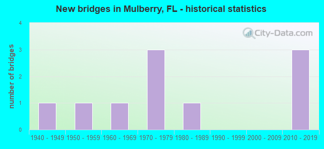
- New bridges - historical statistics
- 11940-1949
- 11950-1959
- 11960-1969
- 31970-1979
- 11980-1989
- 32010-2019

- Reconstructed bridges - Historical Statistics
- 11950-1959
- 01960-1969
- 01970-1979
- 11980-1989


- Bridge Condition - Deck
- 28.6%Very good
- 28.6%Good
- 42.9%Satisfactory

- Bridge Condition - Superstructure
- 42.9%Very good
- 57.1%Good

- Bridge Condition - Substructure
- 42.9%Very good
- 57.1%Good

- Bridge Condition - Channel
- 11.1%Excellent
- 11.1%Very good
- 33.3%Good
- 22.2%Satisfactory
- 22.2%Fair

- Bridge Condition - Culverts
- 33.3%Good
- 66.7%Satisfactory
Find on map >> Show street view
Structure Number: 104436, Location: 1.8 MI E OF KEYSVILLE RD (Lat: 27.876381, Lng: -82.066708), Route carried "on" structure: County highway 676, Year Built: 1972, Status: Open, Structure Length: 0.91m (2.99ft), Average Daily Traffic: 2,200 (year 2021), Truck Traffic: 2%, Average Future Daily Traffic: 2,750 (year 2041), Design Load: H 15, Features Intersected: SLOMAN BRANCH, Facility Carried by Structure: NICHOLS ROAD
Minimum Vertical Clearance: 30+ m (98+ ft), Kilometerpoint: 2.865, Lanes on structure: 2, Owner: County Highway Agency, Approaching Roadway Width: 6.7m (22.0ft), Material/Design: Prestressed concrete, Design/Construction: Channel Beam, Number Of Spans In Main Unit: 1, Length of Maximum Span: 9.1m (29.9ft), Curb or Sidewalk Widths: Left: 0.7m (2.3ft), Right: 0.7m (2.3ft), Curb-To-Curb Width: 8.0m (26.2ft), Out-to-Out Width: 9.8m (32.2ft)
Condition: Deck: Good, Superstructure: Good, Substructure: Good, Channel: Good, Operating Rating: 49.3 metric tons, Method Used To Determine Operating Rating: Load Factor (LF), Inventory Rating: 29.6 metric tons, Method Used To Determine Inventory Rating: Load Factor (LF), Structural Evaluation: Better than present minimum criteria, Deck Geometry: High priority of corrective action, Waterway Adequacy: Better than present minimum criteria, Approach Roadway Alignment: Equal to present desirable criteria, Designated Inspection Frequency: Every 24 months, Inspection Date: December 2021, Deck Structure Type: Concrete Cast-file-Place, Wearing Surface/Protective System: Wearing Surface: Bituminous
Find on map >> Show street view
Structure Number: 160086, Location: 4.5 MI SW OF SR-60 (Lat: 27.879825, Lng: -82.048778), Route carried "on" structure: County highway 676, Year Built: 1972, Status: Open, Structure Length: 5.34m (17.52ft), Average Daily Traffic: 971 (year 2021), Truck Traffic: 3%, Average Future Daily Traffic: 1,685 (year 2042), Design Load: H 20, Features Intersected: THIRTY MILE CREEK
Minimum Vertical Clearance: 30+ m (98+ ft), Kilometerpoint: 0.666, Lanes on structure: 2, Owner: County Highway Agency, Approaching Roadway Width: 9.6m (31.5ft), Material/Design: Concrete continuous, Design/Construction: Slab, Number Of Spans In Main Unit: 6, Length of Maximum Span: 9.0m (29.5ft), Curb-To-Curb Width: 11.7m (38.4ft), Out-to-Out Width: 12.4m (40.7ft)
Condition: Deck: Satisfactory, Superstructure: Good, Substructure: Good, Channel: Good, Operating Rating: 28.2 metric tons, Method Used To Determine Operating Rating: Load Factor (LF), Inventory Rating: 17.0 metric tons, Method Used To Determine Inventory Rating: Load Factor (LF), Structural Evaluation: Meets minimum limits, Deck Geometry: Better than present minimum criteria, Waterway Adequacy: Better than present minimum criteria, Approach Roadway Alignment: Better than present minimum criteria, Designated Inspection Frequency: Every 24 months, Underwater Inspection Frequency: Every 24 months, Inspection Date: September 2021, Underwater Inspection Date: August 2021, Deck Structure Type: Concrete Cast-file-Place
Find on map >> Show street view
Structure Number: 160087, Location: 1MI SOUTHWEST OF SR-60 (Lat: 27.890556, Lng: -82.012861), Route carried "on" structure: County highway 676, Year Built: 1971, Status: Open, Structure Length: 9.17m (30.09ft), Average Daily Traffic: 1,921 (year 2021), Truck Traffic: 6%, Average Future Daily Traffic: 3,332 (year 2042), Design Load: HS 20, Features Intersected: N. PRONG ALAFIA RIVER
Minimum Vertical Clearance: 30+ m (98+ ft), Kilometerpoint: 5.002, Lanes on structure: 2, Owner: County Highway Agency, Approaching Roadway Width: 7.8m (25.6ft), Skew: 1 degrees, Material/Design: Prestressed concrete, Design/Construction: Stringer/Multi-beam, Number Of Spans In Main Unit: 7, Length of Maximum Span: 13.1m (43.0ft), Curb-To-Curb Width: 11.7m (38.4ft), Out-to-Out Width: 12.1m (39.7ft)
Condition: Deck: Satisfactory, Superstructure: Good, Substructure: Good, Channel: Fair, Operating Rating: 46.7 metric tons, Method Used To Determine Operating Rating: Load Factor (LF), Inventory Rating: 28.0 metric tons, Method Used To Determine Inventory Rating: Load Factor (LF), Structural Evaluation: Better than present minimum criteria, Deck Geometry: Equal to present minimum criteria, Waterway Adequacy: Equal to present desirable criteria, Approach Roadway Alignment: Better than present minimum criteria, Designated Inspection Frequency: Every 24 months, Underwater Inspection Frequency: Every 24 months, Inspection Date: September 2021, Underwater Inspection Date: August 2021, Deck Structure Type: Concrete Cast-file-Place
Find on map >> Show street view
Structure Number: 16009, Location: 0.7 MI EAST OF SR-37 (Lat: 27.849953, Lng: -81.966306), Route carried "on" structure: County highway 640, Year Built: 1969, Status: Open, Structure Length: 3.90m (12.80ft), Average Daily Traffic: 4,000 (year 2020), Truck Traffic: 14%, Average Future Daily Traffic: 6,940 (year 2042), Design Load: HS 20, Features Intersected: CSX R/R
Minimum Vertical Clearance: 30+ m (98+ ft), Kilometerpoint: 8.859, Lanes on structure: 2, Owner: County Highway Agency, Approaching Roadway Width: 12.3m (40.4ft), Material/Design: Prestressed concrete, Design/Construction: Stringer/Multi-beam, Number Of Spans In Main Unit: 3, Length of Maximum Span: 14.6m (47.9ft), Curb-To-Curb Width: 12.3m (40.4ft), Out-to-Out Width: 13.0m (42.7ft)
Condition: Deck: Satisfactory, Superstructure: Good, Substructure: Good, Operating Rating: 47.8 metric tons, Method Used To Determine Operating Rating: Load Factor (LF), Inventory Rating: 42.8 metric tons, Method Used To Determine Inventory Rating: Load Factor (LF), Structural Evaluation: Better than present minimum criteria, Deck Geometry: Equal to present minimum criteria, Underclear: Meets minimum limits, Approach Roadway Alignment: Equal to present minimum criteria, Designated Inspection Frequency: Every 24 months, Inspection Date: September 2021, Deck Structure Type: Concrete Cast-file-Place
Find on map >> Show street view
Structure Number: 160127, Location: 0.12 MI EAST OF SR-37 (Lat: 27.894928, Lng: -81.971506), Route carried "on" structure: State highway 60, Year Built: 1942, Year Reconstructed: 1963, Status: Open, Structure Length: 0.96m (3.15ft), Average Daily Traffic: 20,500 (year 2020), Truck Traffic: 24%, Average Future Daily Traffic: 35,568 (year 2042), Design Load: HS 20+Mod, Features Intersected: MULBERRY DRAINAGE CANAL
Minimum Vertical Clearance: 30+ m (98+ ft), Kilometerpoint: 9.576, Lanes on structure: 4, Base Highway Network: Yes, Owner: State Highway Agency, Approaching Roadway Width: 20.7m (67.9ft), Material/Design: Concrete, Design/Construction: Culvert, Number Of Spans In Main Unit: 3, Length of Maximum Span: 3.2m (10.5ft)
Condition: Channel: Satisfactory, Culverts: Satisfactory, Operating Rating: 81.6 metric tons, Method Used To Determine Operating Rating: Load Factor (LF), Inventory Rating: 49.0 metric tons, Method Used To Determine Inventory Rating: Load Factor (LF), Structural Evaluation: Equal to present minimum criteria, Waterway Adequacy: Better than present minimum criteria, Approach Roadway Alignment: Equal to present desirable criteria, Designated Inspection Frequency: Every 24 months, Inspection Date: October 2020
Find on map >> Show street view
Structure Number: 160165, Location: 2.8 MI WEST OF SR-37 (Lat: 27.850742, Lng: -82.022125), Route carried "on" structure: County highway 640, Year Built: 1950, Year Reconstructed: 1985, Status: Open, Structure Length: 0.64m (2.10ft), Average Daily Traffic: 4,000 (year 2020), Truck Traffic: 14%, Average Future Daily Traffic: 10,940 (year 2042), Features Intersected: THIRTY MILE CREEK
Minimum Vertical Clearance: 30+ m (98+ ft), Kilometerpoint: 3.365, Lanes on structure: 2, Owner: County Highway Agency, Approaching Roadway Width: 7.4m (24.3ft), Material/Design: Concrete, Design/Construction: Culvert, Number Of Spans In Main Unit: 2, Length of Maximum Span: 3.0m (9.8ft)
Condition: Channel: Satisfactory, Culverts: Satisfactory, Operating Rating: 46.7 metric tons, Method Used To Determine Operating Rating: Load Factor (LF), Inventory Rating: 28.1 metric tons, Method Used To Determine Inventory Rating: Load Factor (LF), Structural Evaluation: Equal to present minimum criteria, Waterway Adequacy: Equal to present minimum criteria, Approach Roadway Alignment: Equal to present desirable criteria, Designated Inspection Frequency: Every 24 months, Underwater Inspection Frequency: Every 24 months, Inspection Date: September 2021, Underwater Inspection Date: August 2021
Find on map >> Show street view
Structure Number: 160228, Location: 0.4 MI SOUTH OF SR-60 (Lat: 27.889142, Lng: -81.973478), Route carried "on" structure: State highway 37, Year Built: 2014, Status: Open, Structure Length: 7.80m (25.59ft), Average Daily Traffic: 6,000 (year 2020), Truck Traffic: 20%, Average Future Daily Traffic: 10,410 (year 2042), Design Load: HL 93, Features Intersected: NORTH FORK ALAFIA RIVER
Minimum Vertical Clearance: 30+ m (98+ ft), Kilometerpoint: 28.625, Lanes on structure: 2, Owner: State Highway Agency, Approaching Roadway Width: 9.8m (32.2ft), Skew: 1 degrees, Material/Design: Prestressed concrete, Design/Construction: Stringer/Multi-beam, Number Of Spans In Main Unit: 4, Length of Maximum Span: 19.5m (64.0ft), Curb or Sidewalk Widths: Left: 0.0m, Right: 1.5m (4.9ft), Curb-To-Curb Width: 9.8m (32.2ft), Out-to-Out Width: 12.5m (41.0ft)
Condition: Deck: Very good, Superstructure: Very good, Substructure: Very good, Channel: Very good, Operating Rating: 49.0 metric tons, Method Used To Determine Operating Rating: Load and Resistance Factor (LRFR), Inventory Rating: 37.9 metric tons, Method Used To Determine Inventory Rating: Load and Resistance Factor (LRFR), Structural Evaluation: Equal to present desirable criteria, Deck Geometry: Meets minimum limits, Waterway Adequacy: Better than present minimum criteria, Approach Roadway Alignment: Equal to present desirable criteria, Designated Inspection Frequency: Every 24 months, Inspection Date: October 2021, Deck Structure Type: Concrete Cast-file-Place
Find on map >> Show street view
Structure Number: 160347, Location: 0.4 MI S OF SR-60 (Lat: 27.889139, Lng: -81.973633), Route carried "on" structure: State highway 37, Year Built: 2014, Status: Open, Structure Length: 7.80m (25.59ft), Average Daily Traffic: 6,000 (year 2020), Truck Traffic: 20%, Average Future Daily Traffic: 10,410 (year 2042), Design Load: HL 93, Features Intersected: NORTH FORK ALAFIA RIVER
Minimum Vertical Clearance: 30+ m (98+ ft), Kilometerpoint: 28.625, Lanes on structure: 2, Owner: State Highway Agency, Approaching Roadway Width: 9.8m (32.2ft), Skew: 1 degrees, Material/Design: Prestressed concrete, Design/Construction: Stringer/Multi-beam, Number Of Spans In Main Unit: 4, Length of Maximum Span: 19.5m (64.0ft), Curb or Sidewalk Widths: Left: 1.5m (4.9ft), Right: 0.0m, Curb-To-Curb Width: 9.8m (32.2ft), Out-to-Out Width: 12.5m (41.0ft)
Condition: Deck: Good, Superstructure: Very good, Substructure: Very good, Channel: Good, Operating Rating: 49.0 metric tons, Method Used To Determine Operating Rating: Load and Resistance Factor (LRFR), Inventory Rating: 37.9 metric tons, Method Used To Determine Inventory Rating: Load and Resistance Factor (LRFR), Structural Evaluation: Equal to present desirable criteria, Deck Geometry: Meets minimum limits, Waterway Adequacy: Better than present minimum criteria, Approach Roadway Alignment: Equal to present desirable criteria, Designated Inspection Frequency: Every 24 months, Inspection Date: October 2021, Deck Structure Type: Concrete Cast-file-Place
Find on map >> Show street view
Structure Number: 164445, Location: 0.3 MI NORTH OF DEAN ST (Lat: 27.890389, Lng: -81.986689), Route carried "on" structure: County highway , Year Built: 1983, Status: Open, Structure Length: 1.43m (4.69ft), Average Daily Traffic: 985 (year 2021), Truck Traffic: 3%, Average Future Daily Traffic: 1,709 (year 2042), Design Load: HS 20, Features Intersected: N PRONG ALAFIA RIVER, Facility Carried by Structure: KIDD SCHOOL RD.
Minimum Vertical Clearance: 30+ m (98+ ft), Kilometerpoint: 0.000, Lanes on structure: 2, Owner: County Highway Agency, Approaching Roadway Width: 6.6m (21.7ft), Skew: 1 degrees, Material/Design: Concrete, Design/Construction: Culvert, Number Of Spans In Main Unit: 4, Length of Maximum Span: 3.4m (11.2ft)
Condition: Channel: Fair, Culverts: Good, Operating Rating: 73.9 metric tons, Method Used To Determine Operating Rating: Load Factor (LF), Inventory Rating: 44.4 metric tons, Method Used To Determine Inventory Rating: Load Factor (LF), Structural Evaluation: Better than present minimum criteria, Waterway Adequacy: Equal to present minimum criteria, Approach Roadway Alignment: Equal to present desirable criteria, Designated Inspection Frequency: Every 24 months, Underwater Inspection Frequency: Every 24 months, Inspection Date: September 2021, Underwater Inspection Date: August 2021
Find on map >> Show street view
Structure Number: 164554, Location: 2.9 MI E/O COUNTY LINE RD (Lat: 27.952839, Lng: -82.007253), Route carried "on" structure: County highway , Year Built: 2018, Status: Open, Structure Length: 1.80m (5.91ft), Average Daily Traffic: 11,000 (year 2020), Truck Traffic: 14%, Average Future Daily Traffic: 19,085 (year 2042), Design Load: HL 93, Features Intersected: POLEY CREEK, Facility Carried by Structure: EWELL ROAD
Minimum Vertical Clearance: 30+ m (98+ ft), Kilometerpoint: 4.741, Lanes on structure: 2, Owner: County Highway Agency, Approaching Roadway Width: 10.4m (34.1ft), Material/Design: Prestressed concrete, Design/Construction: Slab, Number Of Spans In Main Unit: 1, Length of Maximum Span: 18.0m (59.1ft), Curb-To-Curb Width: 10.4m (34.1ft), Out-to-Out Width: 11.3m (37.1ft)
Condition: Deck: Very good, Superstructure: Very good, Substructure: Very good, Channel: Excellent, Operating Rating: 56.5 metric tons, Method Used To Determine Operating Rating: Load and Resistance Factor (LRFR), Inventory Rating: 45.4 metric tons, Method Used To Determine Inventory Rating: Load and Resistance Factor (LRFR), Structural Evaluation: Equal to present desirable criteria, Deck Geometry: Meets minimum limits, Waterway Adequacy: Superior to present desirable criteria, Approach Roadway Alignment: Equal to present desirable criteria, Designated Inspection Frequency: Every 24 months, Inspection Date: October 2020, Deck Structure Type: Concrete Precast Panels, Wearing Surface/Protective System: Wearing Surface: Integral Concrete