Bridge Statistics for Mountain Home, Idaho (ID)
Condition, Traffic, Stress, Structural Evaluation, Project Costs
- National Bridge Inventory (NBI) Statistics
- 15Number of bridges
- 144ft / 44.2mTotal length
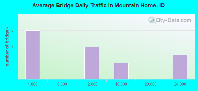
- 130,180Total average daily traffic
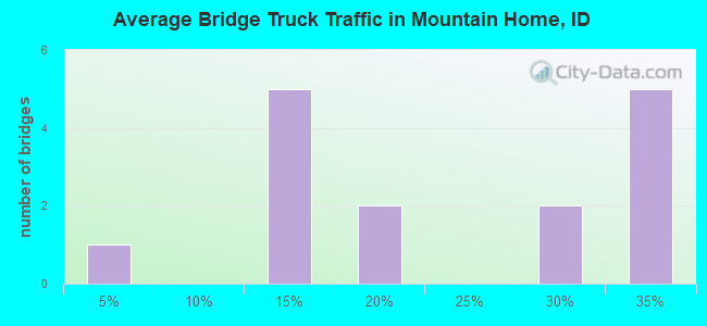
- 35,324Total average daily truck traffic
- National Bridge Inventory (NBI) Registered Bridges for Mountain Home
- No street view available for this location
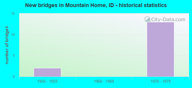
- New bridges - historical statistics
- 21950-1959
- 131970-1979
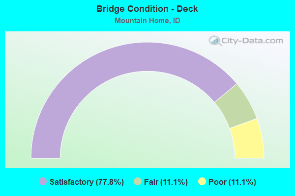
- Bridge Condition - Deck
- 77.8%Satisfactory
- 11.1%Fair
- 11.1%Poor
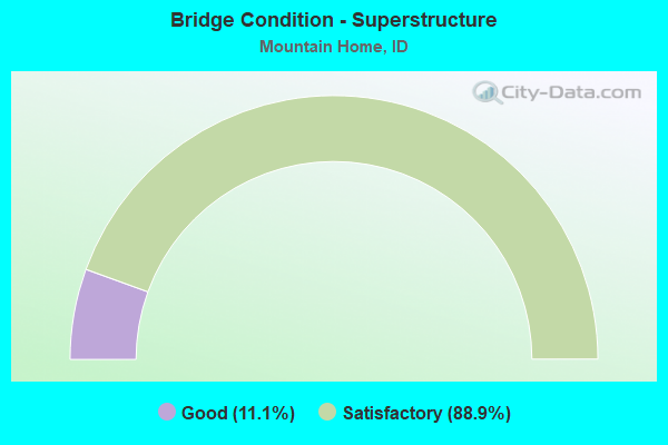
- Bridge Condition - Superstructure
- 11.1%Good
- 88.9%Satisfactory
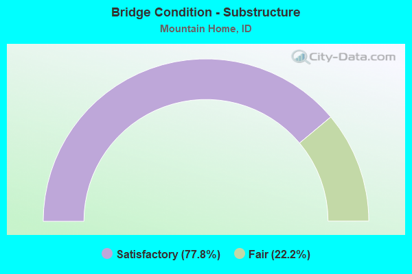
- Bridge Condition - Substructure
- 77.8%Satisfactory
- 22.2%Fair
Find on map >> Show street view
Structure Number: 13755, Location: 3.0 W. MOUNTAIN HOME (Lat: 43.173972, Lng: -115.747028), Route carried "on" structure: Business Interstate 84, Year Built: 1970, Status: Open, Structure Length: 9.75m (31.99ft), Average Daily Traffic: 2,500 (year 2019), Truck Traffic: 10%, Average Future Daily Traffic: 3,750 (year 2039), Design Load: HS 20, Features Intersected: I 84;W.MOUNTAIN HOME IC
Minimum Vertical Clearance: 30+ m (98+ ft), Kilometerpoint: 0.359, Lanes on structure: 2, Lanes under structure: 4, Owner: State Highway Agency, Approaching Roadway Width: 14.6m (47.9ft), Skew: 4 degrees, Material/Design: Steel continuous, Design/Construction: Stringer/Multi-beam, Number Of Spans In Main Unit: 2, Number Of Approach Spans: 2, Length of Maximum Span: 40.2m (131.9ft), Curb-To-Curb Width: 14.6m (47.9ft), Out-to-Out Width: 15.5m (50.9ft)
Condition: Deck: Fair, Superstructure: Satisfactory, Substructure: Satisfactory, Operating Rating: 48.1 metric tons, Method Used To Determine Operating Rating: Load Factor (LF), Inventory Rating: 29.0 metric tons, Method Used To Determine Inventory Rating: Load Factor (LF), Structural Evaluation: Equal to present minimum criteria, Deck Geometry: Superior to present desirable criteria, Underclear: Somewhat better than minimum adequacy, Approach Roadway Alignment: Equal to present desirable criteria, Designated Inspection Frequency: Every 24 months, Other Special Inspection Frequency: Every 48 months, Inspection Date: March 2021, Other Special Inspection Date: March 2021, Deck Structure Type: Concrete Cast-file-Place, Wearing Surface/Protective System: Wearing Surface: Bituminous
Find on map >> Show street view
Structure Number: 13765, Location: 2.0 S. MOUNTAIN HOME (Lat: 43.088639, Lng: -115.662111), Route carried "on" structure: County highway 3813, Year Built: 1973, Status: Open, Structure Length: 8.44m (27.69ft), Average Daily Traffic: 1,800 (year 2019), Truck Traffic: 10%, Average Future Daily Traffic: 2,700 (year 2039), Design Load: HS 20, Features Intersected: STC3816;OLD US 30;UPRR
Minimum Vertical Clearance: 30+ m (98+ ft), Kilometerpoint: 12.648, Lanes on structure: 2, Lanes under structure: 2, Owner: Local Agency, Approaching Roadway Width: 11.0m (36.1ft), Material/Design: Prestressed concrete, Design/Construction: Stringer/Multi-beam, Number Of Spans In Main Unit: 5, Length of Maximum Span: 18.0m (59.1ft), Curb-To-Curb Width: 11.2m (36.7ft), Out-to-Out Width: 12.1m (39.7ft)
Condition: Deck: Poor, Superstructure: Satisfactory, Substructure: Satisfactory, Operating Rating: 57.2 metric tons, Method Used To Determine Operating Rating: Load Factor (LF), Inventory Rating: 33.6 metric tons, Method Used To Determine Inventory Rating: Load Factor (LF), Structural Evaluation: Equal to present minimum criteria, Deck Geometry: Equal to present minimum criteria, Underclear: Meets minimum limits, Approach Roadway Alignment: Better than present minimum criteria, Designated Inspection Frequency: Every 12 months, Inspection Date: April 2021, Deck Structure Type: Concrete Cast-file-Place, Wearing Surface/Protective System: Wearing Surface: Bituminous
Find on map >> Show street view
Structure Number: 1584, Location: 5.5 W. MOUNTAIN HOME (Lat: 43.175500, Lng: -115.757278), Route carried "on" structure: Interstate 84, Year Built: 1959, Year Reconstructed: 1991, Status: Open, Structure Length: 1.10m (3.61ft), Average Daily Traffic: 13,000 (year 2019), Truck Traffic: 27%, Average Future Daily Traffic: 19,500 (year 2039), Design Load: HS 20, Features Intersected: CANYON CREEK
Minimum Vertical Clearance: 30+ m (98+ ft), Kilometerpoint: 144.454, Lanes on structure: 2, Base Highway Network: Yes (Inventory Route: I, Subroute: 1), Owner: State Highway Agency, Approaching Roadway Width: 11.6m (38.1ft), Material/Design: Concrete, Design/Construction: Stringer/Multi-beam, Number Of Spans In Main Unit: 1, Length of Maximum Span: 10.4m (34.1ft), Curb-To-Curb Width: 11.6m (38.1ft), Out-to-Out Width: 12.5m (41.0ft)
Condition: Deck: Satisfactory, Superstructure: Good, Substructure: Satisfactory, Operating Rating: 53.5 metric tons, Method Used To Determine Operating Rating: Load Factor (LF), Inventory Rating: 31.8 metric tons, Method Used To Determine Inventory Rating: Load Factor (LF), Structural Evaluation: Equal to present minimum criteria, Deck Geometry: Equal to present minimum criteria, Approach Roadway Alignment: Equal to present desirable criteria, Designated Inspection Frequency: Every 48 months, Inspection Date: May 2019, Deck Structure Type: Concrete Cast-file-Place, Wearing Surface/Protective System: Wearing Surface: Monolithic Concrete
Find on map >> Show street view
Structure Number: 15845, Location: 5.5 W. MOUNTAIN HOME (Lat: 43.175719, Lng: -115.757050), Route carried "on" structure: Interstate 84, Year Built: 1959, Year Reconstructed: 1991, Status: Open, Structure Length: 1.10m (3.61ft), Average Daily Traffic: 13,000 (year 2019), Truck Traffic: 27%, Average Future Daily Traffic: 19,500 (year 2039), Design Load: HS 20, Features Intersected: CANYON CREEK
Minimum Vertical Clearance: 30+ m (98+ ft), Kilometerpoint: 144.456, Lanes on structure: 2, Base Highway Network: Yes (Inventory Route: I, Subroute: 1), Owner: State Highway Agency, Approaching Roadway Width: 11.6m (38.1ft), Material/Design: Concrete, Design/Construction: Tee Beam, Number Of Spans In Main Unit: 1, Length of Maximum Span: 10.4m (34.1ft), Curb-To-Curb Width: 11.6m (38.1ft), Out-to-Out Width: 12.5m (41.0ft)
Condition: Deck: Satisfactory, Superstructure: Satisfactory, Substructure: Satisfactory, Operating Rating: 53.5 metric tons, Method Used To Determine Operating Rating: Load Factor (LF), Inventory Rating: 31.8 metric tons, Method Used To Determine Inventory Rating: Load Factor (LF), Structural Evaluation: Equal to present minimum criteria, Deck Geometry: Equal to present minimum criteria, Approach Roadway Alignment: Equal to present desirable criteria, Designated Inspection Frequency: Every 48 months, Inspection Date: May 2021, Deck Structure Type: Concrete Cast-file-Place, Wearing Surface/Protective System: Wearing Surface: Monolithic Concrete
Find on map >> Show street view
Structure Number: 15865, Location: 0.3 N. MOUNTAIN HOME (Lat: 43.139436, Lng: -115.663567), Route carried "on" structure: Interstate 84, Year Built: 1971, Status: Open, Structure Length: 2.83m (9.28ft), Average Daily Traffic: 9,250 (year 2019), Truck Traffic: 34%, Average Future Daily Traffic: 13,875 (year 2039), Design Load: HS 20, Features Intersected: US 20;N.MOUNTAIN HOME IC
Minimum Vertical Clearance: 30+ m (98+ ft), Kilometerpoint: 153.211, Lanes on structure: 2, Lanes under structure: 2, Base Highway Network: Yes (Inventory Route: I, Subroute: 1), Owner: State Highway Agency, Approaching Roadway Width: 11.6m (38.1ft), Skew: 3 degrees, Material/Design: Prestressed concrete, Design/Construction: Stringer/Multi-beam, Number Of Spans In Main Unit: 1, Length of Maximum Span: 27.0m (88.6ft), Curb-To-Curb Width: 11.6m (38.1ft), Out-to-Out Width: 12.5m (41.0ft)
Condition: Deck: Satisfactory, Superstructure: Satisfactory, Substructure: Fair, Operating Rating: 75.3 metric tons, Method Used To Determine Operating Rating: Load Factor (LF), Inventory Rating: 43.5 metric tons, Method Used To Determine Inventory Rating: Load Factor (LF), Structural Evaluation: Somewhat better than minimum adequacy, Deck Geometry: Equal to present minimum criteria, Underclear: Somewhat better than minimum adequacy, Approach Roadway Alignment: Equal to present desirable criteria, Designated Inspection Frequency: Every 24 months, Inspection Date: March 2020, Deck Structure Type: Concrete Cast-file-Place, Wearing Surface/Protective System: Wearing Surface: Latex Concrete
Find on map >> Show street view
Structure Number: 1587, Location: 0.3 N. MOUNTAIN HOME (Lat: 43.139306, Lng: -115.663944), Route carried "on" structure: Interstate 84, Year Built: 1971, Status: Open, Structure Length: 2.83m (9.28ft), Average Daily Traffic: 9,250 (year 2019), Truck Traffic: 34%, Average Future Daily Traffic: 13,875 (year 2039), Design Load: HS 20, Features Intersected: US 20;N.MOUNTAIN HOME IC
Minimum Vertical Clearance: 30+ m (98+ ft), Kilometerpoint: 153.227, Lanes on structure: 2, Lanes under structure: 2, Base Highway Network: Yes (Inventory Route: I, Subroute: 1), Owner: State Highway Agency, Approaching Roadway Width: 11.6m (38.1ft), Skew: 3 degrees, Material/Design: Prestressed concrete, Design/Construction: Stringer/Multi-beam, Number Of Spans In Main Unit: 1, Length of Maximum Span: 27.0m (88.6ft), Curb-To-Curb Width: 11.6m (38.1ft), Out-to-Out Width: 12.5m (41.0ft)
Condition: Deck: Satisfactory, Superstructure: Satisfactory, Substructure: Fair, Operating Rating: 75.3 metric tons, Method Used To Determine Operating Rating: Load Factor (LF), Inventory Rating: 43.5 metric tons, Method Used To Determine Inventory Rating: Load Factor (LF), Structural Evaluation: Somewhat better than minimum adequacy, Deck Geometry: Equal to present minimum criteria, Underclear: Meets minimum limits, Approach Roadway Alignment: Equal to present desirable criteria, Designated Inspection Frequency: Every 24 months, Inspection Date: March 2020, Deck Structure Type: Concrete Cast-file-Place, Wearing Surface/Protective System: Wearing Surface: Latex Concrete
Find on map >> Show street view
Structure Number: 27825, Location: 5.0N 0.3E MOUNTAIN HOME (Lat: 43.205400, Lng: -115.689611), Route carried "on" structure: County highway , Year Built: 1978, Status: Open, Structure Length: 0.79m (2.59ft), Average Daily Traffic: 80 (year 2019), Truck Traffic: 13%, Average Future Daily Traffic: 120 (year 2039), Design Load: HS 20, Features Intersected: FEEDER CANAL, Facility Carried by Structure: CANYON CREEK ROAD
Minimum Vertical Clearance: 30+ m (98+ ft), Kilometerpoint: 7.194, Lanes on structure: 2, Owner: Local Agency, Approaching Roadway Width: 5.8m (19.0ft), Material/Design: Prestressed concrete, Design/Construction: Tee Beam, Number Of Spans In Main Unit: 1, Length of Maximum Span: 7.6m (24.9ft), Curb-To-Curb Width: 9.2m (30.2ft), Out-to-Out Width: 9.8m (32.2ft)
Condition: Deck: Satisfactory, Superstructure: Satisfactory, Substructure: Satisfactory, Channel: Satisfactory, Operating Rating: 43.2 metric tons, Method Used To Determine Operating Rating: Allowable Stress (AS), Inventory Rating: 31.5 metric tons, Method Used To Determine Inventory Rating: Allowable Stress (AS), Structural Evaluation: Equal to present minimum criteria, Deck Geometry: Better than present minimum criteria, Waterway Adequacy: Equal to present desirable criteria, Approach Roadway Alignment: Equal to present desirable criteria, Designated Inspection Frequency: Every 24 months, Inspection Date: March 2021, Deck Structure Type: Concrete Cast-file-Place, Wearing Surface/Protective System: Wearing Surface: Monolithic Concrete
Find on map >> Show street view
Structure Number: 27885, Location: 2.8 W. MOUNTAIN HOME (Lat: 43.163978, Lng: -115.707361), Route carried "on" structure: County highway , Year Built: 1971, Status: Open, Structure Length: 8.20m (26.90ft), Average Daily Traffic: 1,700 (year 2019), Truck Traffic: 12%, Average Future Daily Traffic: 2,550 (year 2039), Design Load: HS 20, Features Intersected: I 84;CANYON CREEK RD GS, Facility Carried by Structure: CANYON CREEK ROAD
Minimum Vertical Clearance: 30+ m (98+ ft), Kilometerpoint: 2.087, Lanes on structure: 2, Lanes under structure: 4, Owner: State Highway Agency, Approaching Roadway Width: 9.8m (32.2ft), Material/Design: Steel continuous, Design/Construction: Stringer/Multi-beam, Number Of Spans In Main Unit: 2, Number Of Approach Spans: 2, Length of Maximum Span: 32.3m (106.0ft), Curb-To-Curb Width: 9.1m (29.9ft), Out-to-Out Width: 10.1m (33.1ft)
Condition: Deck: Satisfactory, Superstructure: Satisfactory, Substructure: Satisfactory, Operating Rating: 59.0 metric tons, Method Used To Determine Operating Rating: Load Factor (LF), Inventory Rating: 35.4 metric tons, Method Used To Determine Inventory Rating: Load Factor (LF), Structural Evaluation: Equal to present minimum criteria, Deck Geometry: Somewhat better than minimum adequacy, Underclear: Meets minimum limits, Approach Roadway Alignment: Equal to present desirable criteria, Designated Inspection Frequency: Every 48 months, Other Special Inspection Frequency: Every 48 months, Inspection Date: March 2018, Other Special Inspection Date: March 2018, Deck Structure Type: Concrete Cast-file-Place, Wearing Surface/Protective System: Wearing Surface: Latex Concrete
Find on map >> Show street view
Structure Number: 2789, Location: 1.0 W. MOUNTAIN HOME (Lat: 43.149639, Lng: -115.677528), Route carried "on" structure: County highway , Year Built: 1971, Status: Open, Structure Length: 9.17m (30.09ft), Average Daily Traffic: 1,200 (year 2019), Truck Traffic: 10%, Average Future Daily Traffic: 1,800 (year 2039), Design Load: HS 20, Features Intersected: I 84;EIGHTEENTH ST GS, Facility Carried by Structure: EIGHTEENTH STREET
Minimum Vertical Clearance: 30+ m (98+ ft), Kilometerpoint: 181.719, Lanes on structure: 2, Lanes under structure: 4, Owner: State Highway Agency, Approaching Roadway Width: 9.1m (29.9ft), Skew: 3 degrees, Material/Design: Steel continuous, Design/Construction: Stringer/Multi-beam, Number Of Spans In Main Unit: 2, Number Of Approach Spans: 2, Length of Maximum Span: 35.8m (117.5ft), Curb-To-Curb Width: 9.1m (29.9ft), Out-to-Out Width: 10.1m (33.1ft)
Condition: Deck: Satisfactory, Superstructure: Satisfactory, Substructure: Satisfactory, Operating Rating: 48.1 metric tons, Method Used To Determine Operating Rating: Load Factor (LF), Inventory Rating: 29.0 metric tons, Method Used To Determine Inventory Rating: Load Factor (LF), Structural Evaluation: Equal to present minimum criteria, Deck Geometry: Somewhat better than minimum adequacy, Underclear: Somewhat better than minimum adequacy, Approach Roadway Alignment: Equal to present desirable criteria, Designated Inspection Frequency: Every 24 months, Other Special Inspection Frequency: Every 48 months, Inspection Date: March 2020, Other Special Inspection Date: March 2018, Deck Structure Type: Concrete Cast-file-Place, Wearing Surface/Protective System: Wearing Surface: Latex Concrete
Find on map >> Show street view
Structure Number: 13755, Location: 3.0 W. MOUNTAIN HOME (Lat: 43.173972, Lng: -115.747028), Route carried "under" structure: Interstate 84, Year Built: 1970, Structure Length: 0. m, Average Daily Traffic: 20,000 (year 2018), Truck Traffic: 31%, Features Intersected: I 84;W.MOUNTAIN HOME IC
Minimum Vertical Clearance: 5.18m (16.99ft), Kilometerpoint: 145.361, Lanes on structure: 2, Lanes under structure: 4, Material/Design: Steel continuous, Design/Construction: Stringer/Multi-beam, Length of Maximum Span: 40.2m (131.9ft)
Find on map >> Show street view
Structure Number: 13765, Location: 2.0 S. MOUNTAIN HOME (Lat: 43.088639, Lng: -115.662111), Route carried "under" structure: County highway 3816, Year Built: 1973, Structure Length: 0. m, Average Daily Traffic: 1,000 (year 2018), Truck Traffic: 4%, Features Intersected: STC3816;OLD US 30;UPRR, Facility Carried by Structure: STC3813;OLD ORE TR
Minimum Vertical Clearance: 7.24m (23.75ft), Kilometerpoint: 170.446, Lanes on structure: 2, Lanes under structure: 2, Material/Design: Prestressed concrete, Design/Construction: Stringer/Multi-beam, Length of Maximum Span: 18.0m (59.1ft)
Find on map >> Show street view
Structure Number: 15865, Location: 0.3 N. MOUNTAIN HOME (Lat: 43.139436, Lng: -115.663567), Route carried "under" structure: US 20, Year Built: 1971, Structure Length: 0. m, Average Daily Traffic: 8,700 (year 2018), Truck Traffic: 15%, Features Intersected: US 20;N.MOUNTAIN HOME IC, Facility Carried by Structure: I 84 WBL
Minimum Vertical Clearance: 5.21m (17.09ft), Kilometerpoint: 153.523, Lanes on structure: 2, Lanes under structure: 2, Material/Design: Prestressed concrete, Design/Construction: Stringer/Multi-beam, Length of Maximum Span: 27.0m (88.6ft)
Find on map >> Show street view
Structure Number: 1587, Location: 0.3 N. MOUNTAIN HOME (Lat: 43.139306, Lng: -115.663944), Route carried "under" structure: US 20, Year Built: 1971, Structure Length: 0. m, Average Daily Traffic: 8,700 (year 2018), Truck Traffic: 15%, Features Intersected: US 20;N.MOUNTAIN HOME IC, Facility Carried by Structure: I 84 EBL
Minimum Vertical Clearance: 5.18m (16.99ft), Kilometerpoint: 153.483, Lanes on structure: 2, Lanes under structure: 2, Material/Design: Prestressed concrete, Design/Construction: Stringer/Multi-beam, Length of Maximum Span: 27.0m (88.6ft)
Find on map >> Show street view
Structure Number: 27885, Location: 2.8 W. MOUNTAIN HOME (Lat: 43.163978, Lng: -115.707361), Route carried "under" structure: Interstate 84, Year Built: 1971, Structure Length: 0. m, Average Daily Traffic: 20,000 (year 2018), Truck Traffic: 31%, Features Intersected: I 84;CANYON CREEK RD GS, Facility Carried by Structure: CANYON CREEK ROAD
Minimum Vertical Clearance: 5.28m (17.32ft), Kilometerpoint: 148.711, Lanes on structure: 2, Lanes under structure: 4, Material/Design: Steel continuous, Design/Construction: Stringer/Multi-beam, Length of Maximum Span: 32.3m (106.0ft)
Find on map >> Show street view
Structure Number: 2789, Location: 1.0 W. MOUNTAIN HOME (Lat: 43.149639, Lng: -115.677528), Route carried "under" structure: Interstate 84, Year Built: 1971, Structure Length: 0. m, Average Daily Traffic: 20,000 (year 2018), Truck Traffic: 31%, Features Intersected: I 84;EIGHTEENTH ST GS, Facility Carried by Structure: EIGHTEENTH STREET
Minimum Vertical Clearance: 5.26m (17.26ft), Kilometerpoint: 151.602, Lanes on structure: 2, Lanes under structure: 4, Material/Design: Steel continuous, Design/Construction: Stringer/Multi-beam, Length of Maximum Span: 35.8m (117.5ft)