Bridge Statistics for Mount Union, Pennsylvania (PA)
Condition, Traffic, Stress, Structural Evaluation, Project Costs
- National Bridge Inventory (NBI) Statistics
- 12Number of bridges
- 210ft / 64.3mTotal length
- $2,598,000Total costs
- 39,090Total average daily traffic
- 2,379Total average daily truck traffic
- National Bridge Inventory (NBI) Registered Bridges for Mount Union
- No street view available for this location
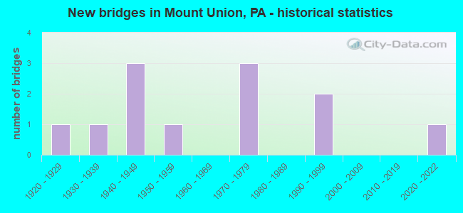
- New bridges - historical statistics
- 11920-1929
- 11930-1939
- 31940-1949
- 11950-1959
- 31970-1979
- 21990-1999
- 12020-2022

- Reconstructed bridges - Historical Statistics
- 12000-2009
- 12010-2019


- Bridge Condition - Deck
- 11.1%Excellent
- 22.2%Good
- 33.3%Satisfactory
- 33.3%Fair

- Bridge Condition - Superstructure
- 22.2%Very good
- 22.2%Good
- 22.2%Satisfactory
- 33.3%Fair

- Bridge Condition - Substructure
- 22.2%Very good
- 22.2%Good
- 33.3%Satisfactory
- 22.2%Fair

- Bridge Condition - Channel
- 30.0%Good
- 30.0%Satisfactory
- 40.0%Fair
Find on map >> Show street view
Structure Number: 18674, Location: 0.3 MI. WEST OF TR 747 (Lat: 40.379172, Lng: -77.874761), Route carried "on" structure: State highway , Year Built: 1952, Status: Open, Structure Length: 1.89m (6.20ft), Average Daily Traffic: 3,442 (year 2021), Truck Traffic: 2%, Average Future Daily Traffic: 5,563 (year 2032), Design Load: H 20, Features Intersected: HILL VALLEY CREEK, Facility Carried by Structure: SR 2025
Minimum Vertical Clearance: 30+ m (98+ ft), Kilometerpoint: 0.455, Lanes on structure: 2, Base Highway Network: Yes, Owner: State Highway Agency, Approaching Roadway Width: 8.8m (28.9ft), Skew: 3 degrees, Material/Design: Concrete, Design/Construction: Tee Beam, Number Of Spans In Main Unit: 2, Length of Maximum Span: 8.8m (28.9ft), Curb or Sidewalk Widths: Left: 1.2m (3.9ft), Right: 0.0m, Curb-To-Curb Width: 11.7m (38.4ft), Out-to-Out Width: 13.9m (45.6ft)
Condition: Deck: Satisfactory, Superstructure: Satisfactory, Substructure: Satisfactory, Channel: Satisfactory, Operating Rating: 68.0 metric tons, Method Used To Determine Operating Rating: Load Factor (LF), Inventory Rating: 40.8 metric tons, Method Used To Determine Inventory Rating: Load Factor (LF), Structural Evaluation: Equal to present minimum criteria, Deck Geometry: Somewhat better than minimum adequacy, Waterway Adequacy: Equal to present desirable criteria, Approach Roadway Alignment: Equal to present desirable criteria, Length Of Structure Improvement: 2.60m (8.53ft), Designated Inspection Frequency: Every 48 months, Inspection Date: June 2020, Deck Structure Type: Concrete Cast-file-Place, Wearing Surface/Protective System: Wearing Surface: Bituminous
Find on map >> Show street view
Structure Number: 18676, Location: AT MIFFLIN COUNTY LINE (Lat: 40.393156, Lng: -77.879019), Route carried "on" structure: State highway 747, Year Built: 1934, Year Reconstructed: 2018, Status: Open, Structure Length: 21.76m (71.39ft), Average Daily Traffic: 3,962 (year 2021), Truck Traffic: 2%, Average Future Daily Traffic: 5,177 (year 2032), Design Load: HS 25 or greater, Features Intersected: JUNIATA RIVER
Minimum Vertical Clearance: 30+ m (98+ ft), Kilometerpoint: 23.715, Lanes on structure: 2, Base Highway Network: Yes, Owner: State Highway Agency, Approaching Roadway Width: 9.1m (29.9ft), Skew: 1 degrees, Material/Design: Prestressed concrete, Design/Construction: Stringer/Multi-beam, Number Of Spans In Main Unit: 6, Length of Maximum Span: 35.7m (117.1ft), Curb or Sidewalk Widths: Left: 1.8m (5.9ft), Right: 0.2m (0.7ft), Curb-To-Curb Width: 12.2m (40.0ft), Out-to-Out Width: 14.9m (48.9ft)
Condition: Deck: Satisfactory, Superstructure: Good, Substructure: Satisfactory, Channel: Satisfactory, Inventory Rating: 47.2 metric tons, Method Used To Determine Inventory Rating: Load Factor (LF), Structural Evaluation: Equal to present minimum criteria, Deck Geometry: Equal to present minimum criteria, Waterway Adequacy: Superior to present desirable criteria, Approach Roadway Alignment: Equal to present desirable criteria, Length Of Structure Improvement: 22.30m (73.16ft), Designated Inspection Frequency: Every 48 months, Underwater Inspection Frequency: Every 60 months, Inspection Date: July 2018, Underwater Inspection Date: October 2021, Deck Structure Type: Concrete Cast-file-Place, Wearing Surface/Protective System: Wearing Surface: Epoxy Overlay, Deck Protection: Galvanized Reinforcing
Find on map >> Show street view
Structure Number: 18719, Location: 0.8 MILE SOUTH OF TR 522 (Lat: 40.374375, Lng: -77.888550), Route carried "on" structure: State highway 747, Year Built: 1949, Year Reconstructed: 2011, Status: Open, Structure Length: 1.89m (6.20ft), Average Daily Traffic: 2,114 (year 2021), Truck Traffic: 2%, Average Future Daily Traffic: 1,684 (year 2032), Design Load: HS 20, Features Intersected: HILL VALLEY CREEK
Minimum Vertical Clearance: 30+ m (98+ ft), Kilometerpoint: 22.072, Lanes on structure: 2, Owner: State Highway Agency, Approaching Roadway Width: 8.5m (27.9ft), Skew: 3 degrees, Material/Design: Concrete, Design/Construction: Tee Beam, Number Of Spans In Main Unit: 2, Length of Maximum Span: 8.8m (28.9ft), Curb-To-Curb Width: 9.1m (29.9ft), Out-to-Out Width: 10.2m (33.5ft)
Condition: Deck: Fair, Superstructure: Fair, Substructure: Good, Channel: Fair, Operating Rating: 64.4 metric tons, Method Used To Determine Operating Rating: Load Factor (LF), Inventory Rating: 39.0 metric tons, Method Used To Determine Inventory Rating: Load Factor (LF), Structural Evaluation: Somewhat better than minimum adequacy, Deck Geometry: Meets minimum limits, Waterway Adequacy: Better than present minimum criteria, Approach Roadway Alignment: Equal to present desirable criteria, Length Of Structure Improvement: 2.40m (7.87ft), Designated Inspection Frequency: Every 24 months, Inspection Date: September 2020, Bridge Improvement Cost: $68,000, Roadway Improvement Cost: $264,000, Total Project Cost: $912,000, Deck Structure Type: Concrete Cast-file-Place, Wearing Surface/Protective System: Wearing Surface: Monolithic Concrete, Deck Protection: Epoxy Coated Reinforcing
Find on map >> Show street view
Structure Number: 26352, Location: 2 MI W NEWTON HAMILTON (Lat: 40.394125, Lng: -77.871106), Route carried "on" structure: US 22, Year Built: 1948, Status: Open, Structure Length: 0.82m (2.69ft), Average Daily Traffic: 5,886 (year 2020), Truck Traffic: 11%, Average Future Daily Traffic: 6,838 (year 2041), Design Load: HS 20, Features Intersected: CARTERS RUN
Minimum Vertical Clearance: 30+ m (98+ ft), Kilometerpoint: 1.514, Lanes on structure: 4, Base Highway Network: Yes, Owner: State Highway Agency, Approaching Roadway Width: 24.1m (79.1ft), Skew: 24 degrees, Material/Design: Concrete, Design/Construction: Culvert, Number Of Spans In Main Unit: 1, Length of Maximum Span: 8.2m (26.9ft)
Condition: Channel: Fair, Culverts: Fair, Inventory Rating: 99.8 metric tons, Method Used To Determine Inventory Rating: Field evaluation and documented engineering judgment, Structural Evaluation: Somewhat better than minimum adequacy, Waterway Adequacy: Superior to present desirable criteria, Approach Roadway Alignment: Equal to present desirable criteria, Length Of Structure Improvement: 0.80m (2.62ft), Designated Inspection Frequency: Every 24 months, Inspection Date: October 2021, Bridge Improvement Cost: $33,000, Roadway Improvement Cost: $250,000, Total Project Cost: $446,000
Find on map >> Show street view
Structure Number: 26353, Location: 2 MI W NEWTON HAMILTON (Lat: 40.409644, Lng: -77.863244), Route carried "on" structure: US 22, Year Built: 1948, Status: Open, Structure Length: 1.04m (3.41ft), Average Daily Traffic: 5,417 (year 2022), Truck Traffic: 6%, Average Future Daily Traffic: 5,901 (year 2041), Design Load: HS 20, Features Intersected: CARTERS RUN
Minimum Vertical Clearance: 30+ m (98+ ft), Kilometerpoint: 2.892, Lanes on structure: 2, Base Highway Network: Yes, Owner: State Highway Agency, Approaching Roadway Width: 9.8m (32.2ft), Skew: 4 degrees, Material/Design: Concrete, Design/Construction: Tee Beam, Number Of Spans In Main Unit: 1, Length of Maximum Span: 10.1m (33.1ft), Curb or Sidewalk Widths: Left: 0.2m (0.7ft), Right: 0.2m (0.7ft), Curb-To-Curb Width: 11.9m (39.0ft), Out-to-Out Width: 13.3m (43.6ft)
Condition: Deck: Fair, Superstructure: Fair, Substructure: Fair, Channel: Fair, Operating Rating: 64.4 metric tons, Method Used To Determine Operating Rating: Load Factor (LF), Inventory Rating: 39.9 metric tons, Method Used To Determine Inventory Rating: Load Factor (LF), Structural Evaluation: Somewhat better than minimum adequacy, Deck Geometry: Somewhat better than minimum adequacy, Waterway Adequacy: Equal to present minimum criteria, Approach Roadway Alignment: Equal to present desirable criteria, Length Of Structure Improvement: 1.00m (3.28ft), Designated Inspection Frequency: Every 24 months, Inspection Date: October 2021, Bridge Improvement Cost: $32,000, Roadway Improvement Cost: $250,000, Total Project Cost: $435,000, Deck Structure Type: Concrete Cast-file-Place, Wearing Surface/Protective System: Wearing Surface: Bituminous
Find on map >> Show street view
Structure Number: 26564, Location: KISTLER (Lat: 40.383075, Lng: -77.873153), Route carried "on" structure: State highway , Year Built: 1971, Status: Open, Structure Length: 15.48m (50.79ft), Average Daily Traffic: 859 (year 2022), Truck Traffic: 1%, Average Future Daily Traffic: 1,217 (year 2041), Design Load: HS 20, Features Intersected: SR 522 JUNIATA R PRIVATE, Facility Carried by Structure: ON TSR 780
Minimum Vertical Clearance: 30+ m (98+ ft), Kilometerpoint: 0.000, Lanes on structure: 2, Lanes under structure: 4, Owner: State Highway Agency, Approaching Roadway Width: 8.2m (26.9ft), Skew: 9 degrees, Material/Design: Steel continuous, Design/Construction: Stringer/Multi-beam, Number Of Spans In Main Unit: 5, Length of Maximum Span: 30.5m (100.1ft), Curb or Sidewalk Widths: Left: 0.5m (1.6ft), Right: 1.5m (4.9ft), Curb-To-Curb Width: 8.5m (27.9ft), Out-to-Out Width: 12.5m (41.0ft)
Condition: Deck: Satisfactory, Superstructure: Satisfactory, Substructure: Satisfactory, Channel: Satisfactory, Operating Rating: 96.2 metric tons, Method Used To Determine Operating Rating: Load Factor (LF), Inventory Rating: 57.2 metric tons, Method Used To Determine Inventory Rating: Load Factor (LF), Structural Evaluation: Equal to present minimum criteria, Deck Geometry: Somewhat better than minimum adequacy, Underclear: Meets minimum limits, Waterway Adequacy: Superior to present desirable criteria, Approach Roadway Alignment: Better than present minimum criteria, Length Of Structure Improvement: 15.30m (50.20ft), Designated Inspection Frequency: Every 24 months, Underwater Inspection Frequency: Every 60 months, Inspection Date: October 2021, Underwater Inspection Date: October 2018, Bridge Improvement Cost: $57,000, Roadway Improvement Cost: $250,000, Total Project Cost: $767,000, Deck Structure Type: Concrete Cast-file-Place, Wearing Surface/Protective System: Wearing Surface: Epoxy Overlay
Find on map >> Show street view
Structure Number: 26651, Location: 100FT WEST OF SR 22 (Lat: 40.402461, Lng: -77.866419), Route carried "on" structure: City street , Year Built: 1926, Status: Open, Structure Length: 0.85m (2.79ft), Average Daily Traffic: 150 (year 2021), Truck Traffic: 5%, Average Future Daily Traffic: 400 (year 2041), Design Load: H 20, Features Intersected: LONG HOLLOW RUN, Facility Carried by Structure: T-343
Minimum Vertical Clearance: 30+ m (98+ ft), Kilometerpoint: 0.000, Lanes on structure: 2, Owner: Town or Township Highway Agency, Approaching Roadway Width: 5.2m (17.1ft), Material/Design: Concrete, Design/Construction: Tee Beam, Number Of Spans In Main Unit: 1, Length of Maximum Span: 7.9m (25.9ft), Curb or Sidewalk Widths: Left: 0.1m (0.3ft), Right: 0.1m (0.3ft), Curb-To-Curb Width: 6.9m (22.6ft), Out-to-Out Width: 7.9m (25.9ft)
Condition: Deck: Fair, Superstructure: Fair, Substructure: Fair, Channel: Fair, Operating Rating: 49.0 metric tons, Method Used To Determine Operating Rating: Field evaluation and documented engineering judgment, Inventory Rating: 32.7 metric tons, Method Used To Determine Inventory Rating: Field evaluation and documented engineering judgment, Structural Evaluation: Somewhat better than minimum adequacy, Deck Geometry: Meets minimum limits, Waterway Adequacy: Better than present minimum criteria, Approach Roadway Alignment: Equal to present desirable criteria, Length Of Structure Improvement: 0.80m (2.62ft), Designated Inspection Frequency: Every 24 months, Inspection Date: June 2021, Bridge Improvement Cost: $3,000, Roadway Improvement Cost: $12,000, Total Project Cost: $38,000, Deck Structure Type: Concrete Cast-file-Place, Wearing Surface/Protective System: Wearing Surface: Bituminous
Find on map >> Show street view
Structure Number: 40242, Location: MOUNT UNION BORO. (Lat: 40.377081, Lng: -77.871686), Route carried "on" structure: US 522, Year Built: 1998, Status: Open, Structure Length: 2.26m (7.41ft), Average Daily Traffic: 5,730 (year 2020), Truck Traffic: 7%, Average Future Daily Traffic: 6,814 (year 2032), Design Load: HS 25 or greater, Features Intersected: HILL VALLEY CREEK
Minimum Vertical Clearance: 30+ m (98+ ft), Kilometerpoint: 37.074, Lanes on structure: 2, Base Highway Network: Yes, Owner: State Highway Agency, Approaching Roadway Width: 13.7m (44.9ft), Material/Design: Prestressed concrete, Design/Construction: Box Beam or Girders - Single/Spread, Number Of Spans In Main Unit: 1, Length of Maximum Span: 21.9m (71.9ft), Curb or Sidewalk Widths: Left: 0.2m (0.7ft), Right: 0.2m (0.7ft), Curb-To-Curb Width: 13.4m (44.0ft), Out-to-Out Width: 14.5m (47.6ft)
Condition: Deck: Good, Superstructure: Very good, Substructure: Very good, Channel: Good, Operating Rating: 81.6 metric tons, Method Used To Determine Operating Rating: Load Factor (LF), Inventory Rating: 45.4 metric tons, Method Used To Determine Inventory Rating: Load Factor (LF), Structural Evaluation: Equal to present desirable criteria, Deck Geometry: Equal to present minimum criteria, Waterway Adequacy: Superior to present desirable criteria, Approach Roadway Alignment: Equal to present desirable criteria, Length Of Structure Improvement: 3.00m (9.84ft), Designated Inspection Frequency: Every 48 months, Inspection Date: August 2019, Deck Structure Type: Concrete Cast-file-Place, Wearing Surface/Protective System: Wearing Surface: Monolithic Concrete, Deck Protection: Epoxy Coated Reinforcing
Find on map >> Show street view
Structure Number: 40244, Location: 522 @ 22 INTERSECTION (Lat: 40.392889, Lng: -77.872008), Route carried "on" structure: US 522, Year Built: 1998, Status: Open, Structure Length: 17.34m (56.89ft), Average Daily Traffic: 5,730 (year 2020), Truck Traffic: 7%, Average Future Daily Traffic: 6,814 (year 2032), Design Load: HS 25 or greater, Features Intersected: JUNIATA RIVER
Minimum Vertical Clearance: 30+ m (98+ ft), Kilometerpoint: 38.251, Lanes on structure: 2, Base Highway Network: Yes, Owner: State Highway Agency, Approaching Roadway Width: 13.7m (44.9ft), Skew: 2 degrees, Material/Design: Prestressed concrete, Design/Construction: Stringer/Multi-beam, Number Of Spans In Main Unit: 4, Length of Maximum Span: 44.2m (145.0ft), Curb or Sidewalk Widths: Left: 0.2m (0.7ft), Right: 0.2m (0.7ft), Curb-To-Curb Width: 13.4m (44.0ft), Out-to-Out Width: 14.5m (47.6ft)
Condition: Deck: Good, Superstructure: Good, Substructure: Good, Channel: Good, Operating Rating: 89.8 metric tons, Method Used To Determine Operating Rating: Load Factor (LF), Inventory Rating: 49.0 metric tons, Method Used To Determine Inventory Rating: Load Factor (LF), Structural Evaluation: Better than present minimum criteria, Deck Geometry: Equal to present minimum criteria, Waterway Adequacy: Superior to present desirable criteria, Approach Roadway Alignment: Equal to present desirable criteria, Length Of Structure Improvement: 18.10m (59.38ft), Designated Inspection Frequency: Every 48 months, Inspection Date: August 2019, Deck Structure Type: Concrete Cast-file-Place, Wearing Surface/Protective System: Wearing Surface: Monolithic Concrete, Deck Protection: Epoxy Coated Reinforcing
Find on map >> Show street view
Structure Number: 68516, Location: BOROUGH OF MOUNT UNION (Lat: 40.380269, Lng: -77.878194), Route carried "on" structure: City street , Year Built: 2021, Status: Open, Structure Length: 0.98m (3.22ft), Average Daily Traffic: 20 (year 2021), Truck Traffic: 1%, Average Future Daily Traffic: 22 (year 2041), Design Load: HL 93, Features Intersected: Hill Valley Creek, Facility Carried by Structure: SOUTH MOORE AVENUE
Minimum Vertical Clearance: 30+ m (98+ ft), Kilometerpoint: 0.000, Lanes on structure: 2, Owner: City or Municipal Highway Agency, Approaching Roadway Width: 6.7m (22.0ft), Material/Design: Prestressed concrete, Design/Construction: Slab, Number Of Spans In Main Unit: 1, Length of Maximum Span: 9.1m (29.9ft), Curb-To-Curb Width: 6.7m (22.0ft), Out-to-Out Width: 7.8m (25.6ft)
Condition: Deck: Excellent, Superstructure: Very good, Substructure: Very good, Channel: Good, Operating Rating: 48.3 metric tons, Method Used To Determine Operating Rating: Assigned ratings based on Load and Resistance Factor Design (LRFD) reported by rating factor (RF) using HL93 loadings, Inventory Rating: 37.3 metric tons, Method Used To Determine Inventory Rating: Assigned ratings based on Load and Resistance Factor Design (LRFD) reported by rating factor (RF) using HL93 loadings, Structural Evaluation: Equal to present desirable criteria, Deck Geometry: Somewhat better than minimum adequacy, Waterway Adequacy: Equal to present minimum criteria, Approach Roadway Alignment: Better than present minimum criteria, Designated Inspection Frequency: Every 24 months, Inspection Date: November 2021, Deck Structure Type: Concrete Cast-file-Place, Wearing Surface/Protective System: Wearing Surface: Monolithic Concrete, Deck Protection: Epoxy Coated Reinforcing
Find on map >> Show street view
Structure Number: 26564, Location: KISTLER (Lat: 40.383075, Lng: -77.873153), Route carried "under" structure: US 522, Year Built: 1971, Structure Length: 0. m, Average Daily Traffic: 5,730 (year 2020), Truck Traffic: 7%, Features Intersected: SR 522 JUNIATA R PRIVATE, Facility Carried by Structure: ON TSR 780
Minimum Vertical Clearance: 9.89m (32.45ft), Kilometerpoint: 37.074, Lanes on structure: 2, Lanes under structure: 2, Material/Design: Steel continuous, Design/Construction: Stringer/Multi-beam, Length of Maximum Span: 30.5m (100.1ft)
Find on map >> Show street view
Structure Number: 26564, Location: KISTLER (Lat: 40.383075, Lng: -77.873153), Route carried "under" structure: ServiceOther road , Year Built: 1971, Structure Length: 0. m, Average Daily Traffic: 50 (year 2004), Features Intersected: SR 522 JUNIATA R PRIVATE, Facility Carried by Structure: ON TSR 780
Minimum Vertical Clearance: 11.98m (39.30ft), Kilometerpoint: 0.000, Lanes on structure: 2, Lanes under structure: 2, Material/Design: Steel continuous, Design/Construction: Stringer/Multi-beam, Length of Maximum Span: 30.5m (100.1ft)