Bridge Statistics for Mount Pocono, Pennsylvania (PA)
Condition, Traffic, Stress, Structural Evaluation, Project Costs
- National Bridge Inventory (NBI) Statistics
- 26Number of bridges
- 125ft / 37.6mTotal length
- $5,324,000Total costs
- 205,472Total average daily traffic
- 23,691Total average daily truck traffic
- National Bridge Inventory (NBI) Registered Bridges for Mount Pocono
- No street view available for this location
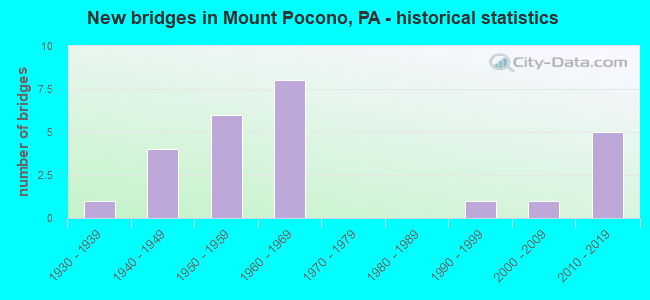
- New bridges - historical statistics
- 11930-1939
- 41940-1949
- 61950-1959
- 81960-1969
- 11990-1999
- 12000-2009
- 52010-2019

- Reconstructed bridges - Historical Statistics
- 41980-1989
- 21990-1999
- 02000-2009
- 22010-2019
- 12020-2022


- Bridge Condition - Deck
- 16.7%Excellent
- 16.7%Very good
- 16.7%Good
- 16.7%Satisfactory
- 27.8%Fair
- 5.6%Poor

- Bridge Condition - Superstructure
- 22.2%Excellent
- 22.2%Very good
- 5.6%Good
- 27.8%Satisfactory
- 22.2%Fair

- Bridge Condition - Substructure
- 5.6%Excellent
- 5.6%Very good
- 27.8%Good
- 27.8%Satisfactory
- 33.3%Fair

- Bridge Condition - Channel
- 5.9%Excellent
- 11.8%Very good
- 23.5%Good
- 11.8%Satisfactory
- 23.5%Fair
- 23.5%Poor

- Bridge Condition - Culverts
- 50.0%Good
- 50.0%Satisfactory
Find on map >> Show street view
Structure Number: 26697, Location: 2.4 MI. W. OF PA 715 (Lat: 41.063333, Lng: -75.340294), Route carried "on" structure: Interstate 80, Year Built: 1962, Year Reconstructed: 1980, Status: Open, Structure Length: 1.83m (6.00ft), Average Daily Traffic: 20,743 (year 2021), Truck Traffic: 26%, Average Future Daily Traffic: 29,198 (year 2032), Design Load: HS 20+Mod, Features Intersected: SR 4004 (LR 45024)
Minimum Vertical Clearance: 30+ m (98+ ft), Kilometerpoint: 21.379, Lanes on structure: 3, Lanes under structure: 2, Base Highway Network: Yes, Owner: State Highway Agency, Approaching Roadway Width: 16.5m (54.1ft), Skew: 15 degrees, Material/Design: Prestressed concrete, Design/Construction: Stringer/Multi-beam, Number Of Spans In Main Unit: 1, Length of Maximum Span: 18.0m (59.1ft), Curb-To-Curb Width: 16.5m (54.1ft), Out-to-Out Width: 17.5m (57.4ft)
Condition: Deck: Fair, Superstructure: Good, Substructure: Satisfactory, Operating Rating: 70.8 metric tons, Method Used To Determine Operating Rating: Load Factor (LF), Inventory Rating: 28.1 metric tons, Method Used To Determine Inventory Rating: Load Factor (LF), Structural Evaluation: Equal to present minimum criteria, Deck Geometry: Equal to present minimum criteria, Underclear: High priority of corrective action, Approach Roadway Alignment: Equal to present desirable criteria, Length Of Structure Improvement: 2.50m (8.20ft), Designated Inspection Frequency: Every 24 months, Inspection Date: March 2020, Bridge Improvement Cost: $11,000, Roadway Improvement Cost: $31,000, Total Project Cost: $143,000, Deck Structure Type: Concrete Cast-file-Place, Wearing Surface/Protective System: Wearing Surface: Monolithic Concrete, Deck Protection: Epoxy Coated Reinforcing
Find on map >> Show street view
Structure Number: 26698, Location: 2.3 MI. W. OF PA 715 (Lat: 41.062617, Lng: -75.339528), Route carried "on" structure: Interstate 80, Year Built: 1962, Year Reconstructed: 1986, Status: Open, Structure Length: 1.37m (4.49ft), Average Daily Traffic: 20,897 (year 2021), Truck Traffic: 32%, Average Future Daily Traffic: 33,672 (year 2032), Design Load: HS 20+Mod, Features Intersected: SR 4004 (LR 45024)
Minimum Vertical Clearance: 30+ m (98+ ft), Kilometerpoint: 21.142, Lanes on structure: 2, Lanes under structure: 2, Base Highway Network: Yes, Owner: State Highway Agency, Approaching Roadway Width: 12.2m (40.0ft), Skew: 14 degrees, Material/Design: Prestressed concrete, Design/Construction: Stringer/Multi-beam, Number Of Spans In Main Unit: 1, Length of Maximum Span: 13.4m (44.0ft), Curb-To-Curb Width: 12.5m (41.0ft), Out-to-Out Width: 13.9m (45.6ft)
Condition: Deck: Fair, Superstructure: Satisfactory, Substructure: Satisfactory, Operating Rating: 79.8 metric tons, Method Used To Determine Operating Rating: Load Factor (LF), Inventory Rating: 30.8 metric tons, Method Used To Determine Inventory Rating: Load Factor (LF), Structural Evaluation: Equal to present minimum criteria, Deck Geometry: Better than present minimum criteria, Underclear: Meets minimum limits, Approach Roadway Alignment: Equal to present desirable criteria, Length Of Structure Improvement: 2.10m (6.89ft), Designated Inspection Frequency: Every 24 months, Inspection Date: September 2021, Bridge Improvement Cost: $7,000, Roadway Improvement Cost: $20,000, Total Project Cost: $91,000, Deck Structure Type: Concrete Cast-file-Place, Wearing Surface/Protective System: Wearing Surface: Monolithic Concrete, Deck Protection: Epoxy Coated Reinforcing
Find on map >> Show street view
Structure Number: 2681, Location: 109 FT.NORTH OF LR168 (Lat: 41.097969, Lng: -75.333708), Route carried "on" structure: State highway 314, Year Built: 1956, Status: Open, Structure Length: 2.10m (6.89ft), Average Daily Traffic: 3,717 (year 2021), Truck Traffic: 5%, Average Future Daily Traffic: 5,597 (year 2032), Design Load: HS 20, Features Intersected: SWIFTWATER CREEK
Minimum Vertical Clearance: 30+ m (98+ ft), Kilometerpoint: 4.728, Lanes on structure: 2, Owner: State Highway Agency, Approaching Roadway Width: 9.1m (29.9ft), Skew: 4 degrees, Material/Design: Steel, Design/Construction: Stringer/Multi-beam, Number Of Spans In Main Unit: 1, Length of Maximum Span: 19.8m (65.0ft), Curb-To-Curb Width: 8.5m (27.9ft), Out-to-Out Width: 9.1m (29.9ft)
Condition: Deck: Poor, Superstructure: Fair, Substructure: Fair, Channel: Poor, Operating Rating: 54.4 metric tons, Method Used To Determine Operating Rating: Load Factor (LF), Inventory Rating: 32.7 metric tons, Method Used To Determine Inventory Rating: Load Factor (LF), Structural Evaluation: Somewhat better than minimum adequacy, Deck Geometry: Meets minimum limits, Waterway Adequacy: Better than present minimum criteria, Approach Roadway Alignment: Better than present minimum criteria, Length Of Structure Improvement: 2.80m (9.19ft), Designated Inspection Frequency: Every 24 months, Inspection Date: September 2021, Bridge Improvement Cost: $6,000, Roadway Improvement Cost: $18,000, Total Project Cost: $81,000, Deck Structure Type: Closed Grating, Wearing Surface/Protective System: Wearing Surface: Bituminous
Find on map >> Show street view
Structure Number: 26822, Location: 4.1 MI.N.OF I-80 (Lat: 41.128778, Lng: -75.400261), Route carried "on" structure: Interstate 380, Year Built: 1969, Year Reconstructed: 1997, Status: Open, Structure Length: 2.13m (6.99ft), Average Daily Traffic: 24,510 (year 2021), Truck Traffic: 23%, Average Future Daily Traffic: 34,491 (year 2032), Design Load: HS 20+Mod, Features Intersected: HAWKEY RUN
Minimum Vertical Clearance: 30+ m (98+ ft), Kilometerpoint: 6.565, Lanes on structure: 4, Base Highway Network: Yes, Owner: State Highway Agency, Approaching Roadway Width: 40.5m (132.9ft), Skew: 23 degrees, Material/Design: Concrete, Design/Construction: Culvert, Number Of Spans In Main Unit: 2, Length of Maximum Span: 6.1m (20.0ft), Curb-To-Curb Width: 25.8m (84.6ft), Out-to-Out Width: 25.8m (84.6ft)
Condition: Channel: Fair, Culverts: Satisfactory, Operating Rating: 47.2 metric tons, Method Used To Determine Operating Rating: Load Factor (LF), Inventory Rating: 28.1 metric tons, Method Used To Determine Inventory Rating: Load Factor (LF), Structural Evaluation: Equal to present minimum criteria, Deck Geometry: Superior to present desirable criteria, Waterway Adequacy: Superior to present desirable criteria, Approach Roadway Alignment: Equal to present desirable criteria, Length Of Structure Improvement: 2.20m (7.22ft), Designated Inspection Frequency: Every 24 months, Inspection Date: September 2021, Bridge Improvement Cost: $62,000, Roadway Improvement Cost: $184,000, Total Project Cost: $842,000
Find on map >> Show street view
Structure Number: 26876, Location: 1MI.S.OF SCOTRUN (Lat: 41.061497, Lng: -75.316997), Route carried "on" structure: State highway 611, Year Built: 1948, Status: Open, Structure Length: 0.91m (2.99ft), Average Daily Traffic: 19,580 (year 2021), Truck Traffic: 3%, Average Future Daily Traffic: 31,584 (year 2032), Design Load: HS 20, Features Intersected: SCOT RUN
Minimum Vertical Clearance: 30+ m (98+ ft), Kilometerpoint: 23.500, Lanes on structure: 3, Owner: State Highway Agency, Approaching Roadway Width: 16.2m (53.1ft), Skew: 3 degrees, Material/Design: Concrete, Design/Construction: Tee Beam, Number Of Spans In Main Unit: 1, Length of Maximum Span: 8.2m (26.9ft), Curb-To-Curb Width: 15.4m (50.5ft), Out-to-Out Width: 16.5m (54.1ft)
Condition: Deck: Satisfactory, Superstructure: Fair, Substructure: Fair, Channel: Poor, Operating Rating: 54.4 metric tons, Method Used To Determine Operating Rating: Load Factor (LF), Inventory Rating: 32.7 metric tons, Method Used To Determine Inventory Rating: Load Factor (LF), Structural Evaluation: Somewhat better than minimum adequacy, Deck Geometry: Equal to present minimum criteria, Waterway Adequacy: Superior to present desirable criteria, Approach Roadway Alignment: Equal to present desirable criteria, Length Of Structure Improvement: 1.60m (5.25ft), Designated Inspection Frequency: Every 24 months, Inspection Date: October 2020, Deck Structure Type: Concrete Cast-file-Place, Wearing Surface/Protective System: Wearing Surface: Bituminous
Find on map >> Show street view
Structure Number: 26878, Location: SCOTRUN (Lat: 41.066486, Lng: -75.319033), Route carried "on" structure: State highway 611, Year Built: 1948, Status: Open, Structure Length: 0.76m (2.49ft), Average Daily Traffic: 19,580 (year 2021), Truck Traffic: 3%, Average Future Daily Traffic: 31,585 (year 2032), Design Load: HS 20, Features Intersected: SCOT RUN
Minimum Vertical Clearance: 30+ m (98+ ft), Kilometerpoint: 24.271, Lanes on structure: 4, Owner: State Highway Agency, Approaching Roadway Width: 20.4m (66.9ft), Skew: 24 degrees, Material/Design: Concrete, Design/Construction: Culvert, Number Of Spans In Main Unit: 1, Length of Maximum Span: 7.6m (24.9ft)
Condition: Channel: Fair, Culverts: Satisfactory, Operating Rating: 52.6 metric tons, Method Used To Determine Operating Rating: Load Factor (LF), Inventory Rating: 31.8 metric tons, Method Used To Determine Inventory Rating: Load Factor (LF), Structural Evaluation: Equal to present minimum criteria, Waterway Adequacy: Superior to present desirable criteria, Approach Roadway Alignment: Equal to present desirable criteria, Length Of Structure Improvement: 1.50m (4.92ft), Designated Inspection Frequency: Every 24 months, Inspection Date: October 2020
Find on map >> Show street view
Structure Number: 26879, Location: SCOTRUN (Lat: 41.069592, Lng: -75.322597), Route carried "on" structure: State highway 611, Year Built: 1948, Year Reconstructed: 2020, Status: Open, Structure Length: 0.82m (2.69ft), Average Daily Traffic: 19,580 (year 2021), Truck Traffic: 3%, Average Future Daily Traffic: 31,585 (year 2032), Design Load: HL 93, Features Intersected: SCOT RUN
Minimum Vertical Clearance: 30+ m (98+ ft), Kilometerpoint: 25.138, Lanes on structure: 4, Owner: State Highway Agency, Approaching Roadway Width: 18.3m (60.0ft), Skew: 24 degrees, Material/Design: Prestressed concrete, Design/Construction: Box Beam or Girders - Multiple, Number Of Spans In Main Unit: 1, Length of Maximum Span: 6.7m (22.0ft), Curb or Sidewalk Widths: Left: 0.2m (0.7ft), Right: 0.2m (0.7ft), Curb-To-Curb Width: 18.4m (60.4ft), Out-to-Out Width: 19.4m (63.6ft)
Condition: Deck: Excellent, Superstructure: Excellent, Substructure: Good, Channel: Satisfactory, Operating Rating: 43.7 metric tons, Method Used To Determine Operating Rating: Assigned ratings based on Load and Resistance Factor Design (LRFD) reported by rating factor (RF) using HL93 loadings, Inventory Rating: 33.7 metric tons, Method Used To Determine Inventory Rating: Assigned ratings based on Load and Resistance Factor Design (LRFD) reported by rating factor (RF) using HL93 loadings, Structural Evaluation: Better than present minimum criteria, Deck Geometry: Somewhat better than minimum adequacy, Waterway Adequacy: Superior to present desirable criteria, Approach Roadway Alignment: Equal to present desirable criteria, Length Of Structure Improvement: 1.30m (4.27ft), Designated Inspection Frequency: Every 24 months, Inspection Date: October 2020, Bridge Improvement Cost: $18,000, Roadway Improvement Cost: $52,000, Total Project Cost: $240,000, Deck Structure Type: Concrete Cast-file-Place, Wearing Surface/Protective System: Wearing Surface: Monolithic Concrete, Deck Protection: Epoxy Coated Reinforcing
Find on map >> Show street view
Structure Number: 26881, Location: SWIFTWATER (Lat: 41.094389, Lng: -75.327064), Route carried "on" structure: State highway 611, Year Built: 1957, Year Reconstructed: 1992, Status: Open, Structure Length: 1.37m (4.49ft), Average Daily Traffic: 19,580 (year 2021), Truck Traffic: 3%, Average Future Daily Traffic: 31,585 (year 2032), Design Load: HS 20, Features Intersected: SWIFTWATER CREEK
Minimum Vertical Clearance: 30+ m (98+ ft), Kilometerpoint: 28.114, Lanes on structure: 4, Owner: State Highway Agency, Approaching Roadway Width: 21.3m (69.9ft), Skew: 24 degrees, Material/Design: Concrete, Design/Construction: Tee Beam, Number Of Spans In Main Unit: 1, Length of Maximum Span: 12.8m (42.0ft), Curb or Sidewalk Widths: Left: 0.2m (0.7ft), Right: 0.2m (0.7ft), Curb-To-Curb Width: 21.5m (70.5ft), Out-to-Out Width: 22.6m (74.1ft)
Condition: Deck: Satisfactory, Superstructure: Satisfactory, Substructure: Fair, Channel: Poor, Operating Rating: 66.2 metric tons, Method Used To Determine Operating Rating: Load Factor (LF), Inventory Rating: 39.0 metric tons, Method Used To Determine Inventory Rating: Load Factor (LF), Structural Evaluation: Somewhat better than minimum adequacy, Deck Geometry: Superior to present desirable criteria, Waterway Adequacy: Superior to present desirable criteria, Approach Roadway Alignment: Equal to present desirable criteria, Length Of Structure Improvement: 2.10m (6.89ft), Designated Inspection Frequency: Every 24 months, Inspection Date: August 2020, Deck Structure Type: Concrete Cast-file-Place, Wearing Surface/Protective System: Wearing Surface: Integral Concrete, Membrane: Epoxy, Deck Protection: Epoxy Coated Reinforcing
Find on map >> Show street view
Structure Number: 26884, Location: NORTH END OF MT.POCONO (Lat: 41.137408, Lng: -75.365772), Route carried "on" structure: State highway 611, Year Built: 1947, Status: Open, Structure Length: 0.82m (2.69ft), Average Daily Traffic: 6,424 (year 2021), Truck Traffic: 8%, Average Future Daily Traffic: 14,593 (year 2032), Design Load: HS 20, Features Intersected: RED RUN
Minimum Vertical Clearance: 30+ m (98+ ft), Kilometerpoint: 34.047, Lanes on structure: 3, Owner: State Highway Agency, Approaching Roadway Width: 15.2m (49.9ft), Skew: 3 degrees, Material/Design: Concrete, Design/Construction: Tee Beam, Number Of Spans In Main Unit: 1, Length of Maximum Span: 7.6m (24.9ft), Curb-To-Curb Width: 15.2m (49.9ft), Out-to-Out Width: 16.3m (53.5ft)
Condition: Deck: Satisfactory, Superstructure: Satisfactory, Substructure: Fair, Channel: Poor, Operating Rating: 49.9 metric tons, Method Used To Determine Operating Rating: Load Factor (LF), Inventory Rating: 29.9 metric tons, Method Used To Determine Inventory Rating: Load Factor (LF), Structural Evaluation: Somewhat better than minimum adequacy, Deck Geometry: Equal to present minimum criteria, Waterway Adequacy: Equal to present minimum criteria, Approach Roadway Alignment: Equal to present desirable criteria, Length Of Structure Improvement: 1.40m (4.59ft), Designated Inspection Frequency: Every 24 months, Inspection Date: October 2020, Deck Structure Type: Concrete Cast-file-Place, Wearing Surface/Protective System: Wearing Surface: Bituminous
Find on map >> Show street view
Structure Number: 26886, Location: VILLAGE OF TOBYHANNA (Lat: 41.167947, Lng: -75.398489), Route carried "on" structure: State highway 611, Year Built: 1939, Year Reconstructed: 1993, Status: Open, Structure Length: 2.62m (8.60ft), Average Daily Traffic: 6,424 (year 2021), Truck Traffic: 8%, Average Future Daily Traffic: 14,593 (year 2032), Design Load: HS 20, Features Intersected: DELAWARE-LACKAWANNA RR
Minimum Vertical Clearance: 30+ m (98+ ft), Kilometerpoint: 37.989, Lanes on structure: 2, Owner: State Highway Agency, Approaching Roadway Width: 13.4m (44.0ft), Skew: 4 degrees, Material/Design: Steel, Design/Construction: Girder and Floorbeam System, Number Of Spans In Main Unit: 1, Length of Maximum Span: 23.2m (76.1ft), Curb or Sidewalk Widths: Left: 0.2m (0.7ft), Right: 0.2m (0.7ft), Curb-To-Curb Width: 14.0m (45.9ft), Out-to-Out Width: 14.8m (48.6ft)
Condition: Deck: Good, Superstructure: Satisfactory, Substructure: Fair, Operating Rating: 89.8 metric tons, Method Used To Determine Operating Rating: Load Factor (LF), Inventory Rating: 53.5 metric tons, Method Used To Determine Inventory Rating: Load Factor (LF), Structural Evaluation: Somewhat better than minimum adequacy, Deck Geometry: Superior to present desirable criteria, Underclear: High priority of corrective action, Approach Roadway Alignment: Equal to present desirable criteria, Length Of Structure Improvement: 3.40m (11.15ft), Designated Inspection Frequency: Every 24 months, Critical Feature Inspection Frequency: Every 24 months, Inspection Date: June 2021, Critical Feature Inspection Date: June 2021, Deck Structure Type: Concrete Cast-file-Place, Wearing Surface/Protective System: Wearing Surface: Monolithic Concrete, Deck Protection: Epoxy Coated Reinforcing
Find on map >> Show street view
Structure Number: 26912, Location: POCONO SUMMIT (Lat: 41.110864, Lng: -75.386250), Route carried "on" structure: State highway 940, Year Built: 1964, Year Reconstructed: 1997, Status: Open, Structure Length: 6.95m (22.80ft), Average Daily Traffic: 18,648 (year 2022), Truck Traffic: 5%, Average Future Daily Traffic: 27,448 (year 2032), Design Load: HS 20, Features Intersected: PA 314 & D&LRR
Minimum Vertical Clearance: 30+ m (98+ ft), Kilometerpoint: 21.206, Lanes on structure: 4, Lanes under structure: 4, Base Highway Network: Yes, Owner: State Highway Agency, Approaching Roadway Width: 20.7m (67.9ft), Skew: 23 degrees, Material/Design: Prestressed concrete, Design/Construction: Stringer/Multi-beam, Number Of Spans In Main Unit: 4, Length of Maximum Span: 23.2m (76.1ft), Curb or Sidewalk Widths: Left: 0.5m (1.6ft), Right: 0.5m (1.6ft), Curb-To-Curb Width: 18.1m (59.4ft), Out-to-Out Width: 20.0m (65.6ft)
Condition: Deck: Fair, Superstructure: Satisfactory, Substructure: Satisfactory, Operating Rating: 64.4 metric tons, Method Used To Determine Operating Rating: Load Factor (LF), Inventory Rating: 10.9 metric tons, Method Used To Determine Inventory Rating: Load Factor (LF), Structural Evaluation: High priority of corrective action, Deck Geometry: Somewhat better than minimum adequacy, Underclear: Somewhat better than minimum adequacy, Approach Roadway Alignment: Equal to present desirable criteria, Length Of Structure Improvement: 7.90m (25.92ft), Designated Inspection Frequency: Every 24 months, Inspection Date: July 2021, Bridge Improvement Cost: $264,000, Roadway Improvement Cost: $776,000, Total Project Cost: $3,558,000, Deck Structure Type: Concrete Cast-file-Place, Wearing Surface/Protective System: Wearing Surface: Epoxy Overlay, Membrane: Epoxy
Find on map >> Show street view
Structure Number: 26938, Location: 2 MI.NORTH OF SWIFTWATER (Lat: 41.114128, Lng: -75.312311), Route carried "on" structure: State highway , Year Built: 1956, Year Reconstructed: 2017, Status: Open, Structure Length: 0.79m (2.59ft), Average Daily Traffic: 1,408 (year 2022), Truck Traffic: 6%, Average Future Daily Traffic: 4,644 (year 2032), Design Load: HS 20, Features Intersected: FOREST HILLS RUN, Facility Carried by Structure: SR 1011(LR 45034)
Minimum Vertical Clearance: 30+ m (98+ ft), Kilometerpoint: 2.874, Lanes on structure: 2, Owner: State Highway Agency, Approaching Roadway Width: 11.0m (36.1ft), Material/Design: Concrete, Design/Construction: Channel Beam, Number Of Spans In Main Unit: 1, Length of Maximum Span: 7.0m (23.0ft), Curb-To-Curb Width: 10.5m (34.4ft), Out-to-Out Width: 11.6m (38.1ft)
Condition: Deck: Very good, Superstructure: Very good, Substructure: Good, Channel: Good, Inventory Rating: 92.5 metric tons, Method Used To Determine Inventory Rating: Load Factor (LF), Structural Evaluation: Better than present minimum criteria, Deck Geometry: Equal to present minimum criteria, Waterway Adequacy: Equal to present minimum criteria, Approach Roadway Alignment: Better than present minimum criteria, Length Of Structure Improvement: 1.40m (4.59ft), Designated Inspection Frequency: Every 24 months, Inspection Date: August 2021, Bridge Improvement Cost: $8,000, Roadway Improvement Cost: $24,000, Total Project Cost: $110,000, Deck Structure Type: Concrete Cast-file-Place, Wearing Surface/Protective System: Wearing Surface: Monolithic Concrete, Deck Protection: Epoxy Coated Reinforcing
Find on map >> Show street view
Structure Number: 27103, Location: 0.5 MI. NE INT OF T-561 (Lat: 41.132586, Lng: -75.315586), Route carried "on" structure: City street , Year Built: 1956, Year Reconstructed: 2018, Status: Open, Structure Length: 0.91m (2.99ft), Average Daily Traffic: 125 (year 1985), Average Future Daily Traffic: 125 (year 2030), Design Load: HL 93, Features Intersected: DEVILS HOLE CREEK, Facility Carried by Structure: KOERNERS RD
Minimum Vertical Clearance: 30+ m (98+ ft), Kilometerpoint: 0.000, Lanes on structure: 2, Owner: Town or Township Highway Agency, Approaching Roadway Width: 7.0m (23.0ft), Skew: 1 degrees, Material/Design: Prestressed concrete, Design/Construction: Box Beam or Girders - Single/Spread, Number Of Spans In Main Unit: 1, Length of Maximum Span: 8.5m (27.9ft), Curb or Sidewalk Widths: Left: 0.5m (1.6ft), Right: 0.5m (1.6ft), Curb-To-Curb Width: 7.6m (24.9ft), Out-to-Out Width: 8.4m (27.6ft)
Condition: Deck: Very good, Superstructure: Very good, Substructure: Good, Channel: Good, Operating Rating: 56.4 metric tons, Method Used To Determine Operating Rating: Assigned ratings based on Load and Resistance Factor Design (LRFD) reported by rating factor (RF) using HL93 loadings, Inventory Rating: 43.4 metric tons, Method Used To Determine Inventory Rating: Assigned ratings based on Load and Resistance Factor Design (LRFD) reported by rating factor (RF) using HL93 loadings, Structural Evaluation: Better than present minimum criteria, Deck Geometry: Somewhat better than minimum adequacy, Waterway Adequacy: Equal to present desirable criteria, Approach Roadway Alignment: Equal to present desirable criteria, Length Of Structure Improvement: 0.90m (2.95ft), Designated Inspection Frequency: Every 24 months, Inspection Date: August 2020, Bridge Improvement Cost: $2,000, Roadway Improvement Cost: $10,000, Total Project Cost: $25,000, Wearing Surface/Protective System: Wearing Surface: Monolithic Concrete, Deck Protection: Epoxy Coated Reinforcing
Find on map >> Show street view
Structure Number: 27106, Location: 0.5 M.S OF POCONO GARDENS (Lat: 41.122936, Lng: -75.292697), Route carried "on" structure: City street , Year Built: 1956, Status: Open, Structure Length: 2.07m (6.79ft), Average Daily Traffic: 157 (year 2005), Average Future Daily Traffic: 175 (year 2055), Design Load: H 20, Features Intersected: PARADISE CREEK, Facility Carried by Structure: T-603
Minimum Vertical Clearance: 30+ m (98+ ft), Kilometerpoint: 0.000, Lanes on structure: 2, Owner: County Highway Agency, Approaching Roadway Width: 6.1m (20.0ft), Skew: 4 degrees, Material/Design: Prestressed concrete, Design/Construction: Box Beam or Girders - Multiple, Number Of Spans In Main Unit: 1, Length of Maximum Span: 20.1m (65.9ft), Curb or Sidewalk Widths: Left: 0.2m (0.7ft), Right: 0.2m (0.7ft), Curb-To-Curb Width: 7.6m (24.9ft), Out-to-Out Width: 8.0m (26.2ft)
Condition: Deck: Fair, Superstructure: Fair, Substructure: Fair, Channel: Fair, Operating Rating: 74.4 metric tons, Method Used To Determine Operating Rating: Load Factor (LF), Inventory Rating: 20.9 metric tons, Method Used To Determine Inventory Rating: Load Factor (LF), Structural Evaluation: Somewhat better than minimum adequacy, Deck Geometry: Somewhat better than minimum adequacy, Waterway Adequacy: Superior to present desirable criteria, Approach Roadway Alignment: Equal to present desirable criteria, Length Of Structure Improvement: 2.10m (6.89ft), Designated Inspection Frequency: Every 24 months, Inspection Date: August 2020, Bridge Improvement Cost: $3,000, Roadway Improvement Cost: $10,000, Total Project Cost: $45,000, Deck Structure Type: Other, Wearing Surface/Protective System: Wearing Surface: Bituminous
Find on map >> Show street view
Structure Number: 27107, Location: 0.2 M.N OF POCONO GARDENS (Lat: 41.126553, Lng: -75.304683), Route carried "on" structure: City street , Year Built: 1957, Status: Open, Structure Length: 1.22m (4.00ft), Average Daily Traffic: 157 (year 2005), Average Future Daily Traffic: 175 (year 2055), Design Load: HS 20, Features Intersected: PARADISE CREEK, Facility Carried by Structure: KEOKEE CHAPEL LN
Minimum Vertical Clearance: 30+ m (98+ ft), Kilometerpoint: 0.000, Lanes on structure: 2, Owner: County Highway Agency, Approaching Roadway Width: 6.7m (22.0ft), Skew: 1 degrees, Material/Design: Prestressed concrete, Design/Construction: Box Beam or Girders - Multiple, Number Of Spans In Main Unit: 1, Length of Maximum Span: 11.0m (36.1ft), Curb or Sidewalk Widths: Left: 0.2m (0.7ft), Right: 0.2m (0.7ft), Curb-To-Curb Width: 7.6m (24.9ft), Out-to-Out Width: 8.0m (26.2ft)
Condition: Deck: Fair, Superstructure: Fair, Substructure: Satisfactory, Channel: Satisfactory, Operating Rating: 57.2 metric tons, Method Used To Determine Operating Rating: Load Factor (LF), Inventory Rating: 18.1 metric tons, Method Used To Determine Inventory Rating: Load Factor (LF), Structural Evaluation: Somewhat better than minimum adequacy, Deck Geometry: Somewhat better than minimum adequacy, Waterway Adequacy: Better than present minimum criteria, Approach Roadway Alignment: Equal to present desirable criteria, Length Of Structure Improvement: 1.30m (4.27ft), Designated Inspection Frequency: Every 24 months, Inspection Date: August 2020, Bridge Improvement Cost: $14,000, Roadway Improvement Cost: $122,000, Total Project Cost: $189,000, Deck Structure Type: Other, Wearing Surface/Protective System: Wearing Surface: Bituminous, Membrane: Preformed Fabric
Find on map >> Show street view
Structure Number: 42585, Location: FAIRVIEW AVENUE (Lat: 41.114286, Lng: -75.367528), Route carried "on" structure: State highway , Year Built: 2004, Status: Open, Structure Length: 1.80m (5.91ft), Average Daily Traffic: 991 (year 2022), Truck Traffic: 3%, Average Future Daily Traffic: 1,184 (year 2032), Design Load: HL 93, Features Intersected: DELAWARE-LACKAWANNA RR, Facility Carried by Structure: SR 4007 (LR 45035)
Minimum Vertical Clearance: 30+ m (98+ ft), Kilometerpoint: 2.535, Lanes on structure: 2, Owner: State Highway Agency, Approaching Roadway Width: 9.8m (32.2ft), Material/Design: Prestressed concrete, Design/Construction: Box Beam or Girders - Multiple, Number Of Spans In Main Unit: 1, Length of Maximum Span: 18.0m (59.1ft), Curb or Sidewalk Widths: Left: 1.9m (6.2ft), Right: 0.0m, Curb-To-Curb Width: 9.8m (32.2ft), Out-to-Out Width: 13.0m (42.7ft)
Condition: Deck: Good, Superstructure: Very good, Substructure: Satisfactory, Operating Rating: 78.9 metric tons, Method Used To Determine Operating Rating: Load and Resistance Factor (LRFR), Inventory Rating: 39.9 metric tons, Method Used To Determine Inventory Rating: Load and Resistance Factor (LRFR), Structural Evaluation: Equal to present minimum criteria, Deck Geometry: Equal to present minimum criteria, Underclear: High priority of corrective action, Approach Roadway Alignment: Equal to present desirable criteria, Designated Inspection Frequency: Every 48 months, Inspection Date: January 2019, Deck Structure Type: Concrete Cast-file-Place, Wearing Surface/Protective System: Wearing Surface: Monolithic Concrete, Deck Protection: Epoxy Coated Reinforcing
Find on map >> Show street view
Structure Number: 47832, Location: 1 MI.W.OF SWIFTWATER (Lat: 41.100775, Lng: -75.346556), Route carried "on" structure: State highway 314, Year Built: 2013, Status: Open, Structure Length: 1.16m (3.81ft), Average Daily Traffic: 3,717 (year 2021), Truck Traffic: 5%, Average Future Daily Traffic: 4,140 (year 2032), Design Load: HL 93, Features Intersected: SWIFTWATER CREEK
Minimum Vertical Clearance: 30.18m (99.02ft), Kilometerpoint: 3.621, Lanes on structure: 2, Owner: State Highway Agency, Approaching Roadway Width: 9.4m (30.8ft), Skew: 4 degrees, Material/Design: Prestressed concrete, Design/Construction: Box Beam or Girders - Single/Spread, Number Of Spans In Main Unit: 1, Length of Maximum Span: 11.3m (37.1ft), Curb or Sidewalk Widths: Left: 0.2m (0.7ft), Right: 0.2m (0.7ft), Curb-To-Curb Width: 9.1m (29.9ft), Out-to-Out Width: 10.2m (33.5ft)
Condition: Deck: Good, Superstructure: Very good, Substructure: Good, Channel: Good, Operating Rating: 65.1 metric tons, Method Used To Determine Operating Rating: Assigned ratings based on Load and Resistance Factor Design (LRFD) reported by rating factor (RF) using HL93 loadings, Inventory Rating: 40.8 metric tons, Method Used To Determine Inventory Rating: Assigned ratings based on Load and Resistance Factor Design (LRFD) reported by rating factor (RF) using HL93 loadings, Structural Evaluation: Better than present minimum criteria, Deck Geometry: Meets minimum limits, Waterway Adequacy: Equal to present desirable criteria, Approach Roadway Alignment: Equal to present desirable criteria, Designated Inspection Frequency: Every 48 months, Inspection Date: April 2019, Deck Structure Type: Concrete Cast-file-Place, Wearing Surface/Protective System: Wearing Surface: Monolithic Concrete, Deck Protection: Epoxy Coated Reinforcing
Find on map >> Show street view
Structure Number: 52749, Location: 2.5 MI E. OF SWIFTWATER (Lat: 41.091039, Lng: -75.286858), Route carried "on" structure: State highway 314, Year Built: 2015, Status: Open, Structure Length: 1.74m (5.71ft), Average Daily Traffic: 722 (year 2020), Truck Traffic: 4%, Average Future Daily Traffic: 655 (year 2037), Design Load: HL 93, Features Intersected: Swiftwater Creek, Facility Carried by Structure: Club House Rd
Minimum Vertical Clearance: 30+ m (98+ ft), Kilometerpoint: 8.742, Lanes on structure: 2, Owner: State Highway Agency, Maintenance Responsibility: Private, Approaching Roadway Width: 6.7m (22.0ft), Material/Design: Prestressed concrete, Design/Construction: Box Beam or Girders - Single/Spread, Number Of Spans In Main Unit: 1, Length of Maximum Span: 16.8m (55.1ft), Curb-To-Curb Width: 9.3m (30.5ft), Out-to-Out Width: 9.9m (32.5ft)
Condition: Deck: Excellent, Superstructure: Excellent, Substructure: Very good, Channel: Very good, Operating Rating: 57.3 metric tons, Method Used To Determine Operating Rating: Assigned ratings based on Load and Resistance Factor Design (LRFD) reported by rating factor (RF) using HL93 loadings, Inventory Rating: 44.4 metric tons, Method Used To Determine Inventory Rating: Assigned ratings based on Load and Resistance Factor Design (LRFD) reported by rating factor (RF) using HL93 loadings, Structural Evaluation: Equal to present desirable criteria, Deck Geometry: Equal to present minimum criteria, Waterway Adequacy: Equal to present minimum criteria, Approach Roadway Alignment: Equal to present desirable criteria, Designated Inspection Frequency: Every 24 months, Inspection Date: May 2021, Deck Structure Type: Concrete Cast-file-Place, Wearing Surface/Protective System: Wearing Surface: Integral Concrete, Deck Protection: Epoxy Coated Reinforcing
Find on map >> Show street view
Structure Number: 53388, Location: .7 M. W. OF LR 45024 (Lat: 41.053708, Lng: -75.340414), Route carried "on" structure: Spur State highway , Year Built: 2017, Status: Open, Structure Length: 2.87m (9.42ft), Average Daily Traffic: 2,195 (year 2022), Truck Traffic: 10%, Average Future Daily Traffic: 3,913 (year 2032), Design Load: HL 93, Features Intersected: Pocono Creek, Facility Carried by Structure: Camelback Rd
Minimum Vertical Clearance: 30+ m (98+ ft), Kilometerpoint: 2.729, Lanes on structure: 2, Owner: State Highway Agency, Maintenance Responsibility: Private, Approaching Roadway Width: 7.6m (24.9ft), Skew: 3 degrees, Material/Design: Prestressed concrete, Design/Construction: Box Beam or Girders - Single/Spread, Number Of Spans In Main Unit: 1, Length of Maximum Span: 27.1m (88.9ft), Curb-To-Curb Width: 12.6m (41.3ft), Out-to-Out Width: 13.3m (43.6ft)
Condition: Deck: Excellent, Superstructure: Excellent, Substructure: Excellent, Channel: Excellent, Operating Rating: 55.4 metric tons, Method Used To Determine Operating Rating: Assigned ratings based on Load and Resistance Factor Design (LRFD) reported by rating factor (RF) using HL93 loadings, Inventory Rating: 41.5 metric tons, Method Used To Determine Inventory Rating: Assigned ratings based on Load and Resistance Factor Design (LRFD) reported by rating factor (RF) using HL93 loadings, Structural Evaluation: Superior to present desirable criteria, Deck Geometry: Equal to present minimum criteria, Waterway Adequacy: Superior to present desirable criteria, Approach Roadway Alignment: Better than present minimum criteria, Designated Inspection Frequency: Every 24 months, Inspection Date: July 2020, Deck Structure Type: Concrete Cast-file-Place, Wearing Surface/Protective System: Wearing Surface: Integral Concrete, Deck Protection: Epoxy Coated Reinforcing
Find on map >> Show street view
Structure Number: 53451, Location: 2 MI.E. OF MT. POCONO (Lat: 41.127131, Lng: -75.307608), Route carried "on" structure: State highway 940, Year Built: 2016, Status: Open, Structure Length: 1.89m (6.20ft), Average Daily Traffic: 6,706 (year 2022), Truck Traffic: 7%, Average Future Daily Traffic: 10,520 (year 2037), Design Load: HL 93, Features Intersected: Paradise Creek, Facility Carried by Structure: Paradise Valley Rd
Minimum Vertical Clearance: 30+ m (98+ ft), Kilometerpoint: 28.645, Lanes on structure: 2, Owner: State Highway Agency, Maintenance Responsibility: Private, Approaching Roadway Width: 12.2m (40.0ft), Skew: 4 degrees, Material/Design: Prestressed concrete, Design/Construction: Box Beam or Girders - Single/Spread, Number Of Spans In Main Unit: 1, Length of Maximum Span: 18.3m (60.0ft), Curb-To-Curb Width: 12.2m (40.0ft), Out-to-Out Width: 12.8m (42.0ft)
Condition: Deck: Very good, Superstructure: Excellent, Substructure: Good, Channel: Very good, Operating Rating: 46.7 metric tons, Method Used To Determine Operating Rating: Assigned ratings based on Load and Resistance Factor Design (LRFD) reported by rating factor (RF) using HL93 loadings, Inventory Rating: 36.0 metric tons, Method Used To Determine Inventory Rating: Assigned ratings based on Load and Resistance Factor Design (LRFD) reported by rating factor (RF) using HL93 loadings, Structural Evaluation: Better than present minimum criteria, Deck Geometry: Somewhat better than minimum adequacy, Waterway Adequacy: Superior to present desirable criteria, Approach Roadway Alignment: Equal to present desirable criteria, Designated Inspection Frequency: Every 24 months, Inspection Date: May 2021, Deck Structure Type: Concrete Cast-file-Place, Wearing Surface/Protective System: Wearing Surface: Integral Concrete, Deck Protection: Epoxy Coated Reinforcing
Find on map >> Show street view
Structure Number: 56918, Location: 0.2 MI WEST OF PA611 (Lat: 41.072500, Lng: -75.327194), Route carried "on" structure: City street , Year Built: 2019, Status: Open, Structure Length: 0.79m (2.59ft), Average Daily Traffic: 500 (year 2020), Average Future Daily Traffic: 1,000 (year 2040), Features Intersected: Scot Run, Facility Carried by Structure: Frantz Hill Road
Minimum Vertical Clearance: 30+ m (98+ ft), Kilometerpoint: 0.000, Lanes on structure: 2, Owner: Town or Township Highway Agency, Approaching Roadway Width: 7.3m (24.0ft), Material/Design: Concrete, Design/Construction: Culvert, Number Of Spans In Main Unit: 1, Length of Maximum Span: 7.3m (24.0ft), Curb-To-Curb Width: 7.3m (24.0ft), Out-to-Out Width: 8.5m (27.9ft)
Condition: Channel: Good, Culverts: Good, Operating Rating: 86.2 metric tons, Method Used To Determine Operating Rating: Field evaluation and documented engineering judgment, Inventory Rating: 51.7 metric tons, Method Used To Determine Inventory Rating: Field evaluation and documented engineering judgment, Structural Evaluation: Better than present minimum criteria, Deck Geometry: Meets minimum limits, Waterway Adequacy: Better than present minimum criteria, Approach Roadway Alignment: Equal to present desirable criteria, Designated Inspection Frequency: Every 24 months, Inspection Date: November 2020, Wearing Surface/Protective System: Wearing Surface: Bituminous, Deck Protection: Epoxy Coated Reinforcing
Find on map >> Show street view
Structure Number: 56921, Location: 1.5 MI WEST OF PA611 (Lat: 41.128611, Lng: -75.384944), Route carried "on" structure: City street , Year Built: 1998, Status: Open, Structure Length: 0.73m (2.40ft), Average Daily Traffic: 350 (year 2020), Truck Traffic: 20%, Average Future Daily Traffic: 500 (year 2040), Features Intersected: Red Run Tributary, Facility Carried by Structure: Industrial Park Dr
Minimum Vertical Clearance: 30+ m (98+ ft), Kilometerpoint: 0.000, Lanes on structure: 2, Owner: Town or Township Highway Agency, Approaching Roadway Width: 7.3m (24.0ft), Material/Design: Steel, Design/Construction: Culvert, Number Of Spans In Main Unit: 1, Length of Maximum Span: 7.3m (24.0ft), Curb-To-Curb Width: 11.5m (37.7ft), Out-to-Out Width: 12.3m (40.4ft)
Condition: Channel: Fair, Culverts: Good, Operating Rating: 69.9 metric tons, Method Used To Determine Operating Rating: Load and Resistance Factor (LRFR), Inventory Rating: 53.5 metric tons, Method Used To Determine Inventory Rating: Load and Resistance Factor (LRFR), Structural Evaluation: Better than present minimum criteria, Deck Geometry: Superior to present desirable criteria, Waterway Adequacy: Better than present minimum criteria, Approach Roadway Alignment: Equal to present desirable criteria, Designated Inspection Frequency: Every 24 months, Inspection Date: November 2020
Find on map >> Show street view
Structure Number: 26697, Location: 2.4 MI. W. OF PA 715 (Lat: 41.063333, Lng: -75.340294), Route carried "under" structure: State highway , Year Built: 1962, Structure Length: 0. m, Average Daily Traffic: 1,207 (year 2020), Truck Traffic: 5%, Features Intersected: SR 4004 (LR 45024), Facility Carried by Structure: I-80 WB (LR 1002)
Minimum Vertical Clearance: 4.91m (16.11ft), Kilometerpoint: 3.671, Lanes on structure: 3, Lanes under structure: 2, Material/Design: Prestressed concrete, Design/Construction: Stringer/Multi-beam, Length of Maximum Span: 18.0m (59.1ft)
Find on map >> Show street view
Structure Number: 26698, Location: 2.3 MI. W. OF PA 715 (Lat: 41.062617, Lng: -75.339528), Route carried "under" structure: State highway , Year Built: 1962, Structure Length: 0. m, Average Daily Traffic: 1,207 (year 2020), Truck Traffic: 5%, Features Intersected: SR 4004 (LR 45024), Facility Carried by Structure: I-80 EB (LR 1002)
Minimum Vertical Clearance: 4.69m (15.39ft), Kilometerpoint: 3.671, Lanes on structure: 2, Lanes under structure: 2, Material/Design: Prestressed concrete, Design/Construction: Stringer/Multi-beam, Length of Maximum Span: 13.4m (44.0ft)
Find on map >> Show street view
Structure Number: 26912, Location: POCONO SUMMIT (Lat: 41.110864, Lng: -75.386250), Route carried "under" structure: State highway , Year Built: 1964, Structure Length: 0. m, Average Daily Traffic: 2,520 (year 2021), Truck Traffic: 5%, Features Intersected: PA 314 & D&LRR, Facility Carried by Structure: PA 940 (LR 169)
Minimum Vertical Clearance: 4.40m (14.44ft), Kilometerpoint: 0.000, Lanes on structure: 4, Lanes under structure: 2, Material/Design: Prestressed concrete, Design/Construction: Stringer/Multi-beam, Length of Maximum Span: 23.2m (76.1ft)
Find on map >> Show street view
Structure Number: 26912, Location: POCONO SUMMIT (Lat: 41.110864, Lng: -75.386250), Route carried "under" structure: State highway 314, Year Built: 1964, Structure Length: 0. m, Average Daily Traffic: 3,827 (year 2021), Truck Traffic: 4%, Features Intersected: PA 314 & D&LRR, Facility Carried by Structure: PA 940 (LR 169)
Minimum Vertical Clearance: 4.40m (14.44ft), Kilometerpoint: 0.000, Lanes on structure: 4, Lanes under structure: 2, Material/Design: Prestressed concrete, Design/Construction: Stringer/Multi-beam, Length of Maximum Span: 23.2m (76.1ft)