Bridge Statistics for Mount Plymouth, Florida (FL)
Condition, Traffic, Stress, Structural Evaluation, Project Costs
- National Bridge Inventory (NBI) Statistics
- 11Number of bridges
- 568ft / 173mTotal length
- 65,400Total average daily traffic
- 9,117Total average daily truck traffic
- National Bridge Inventory (NBI) Registered Bridges for Mount Plymouth
- No street view available for this location
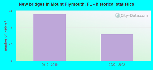
- New bridges - historical statistics
- 72010-2019
- 42020-2022


- Bridge Condition - Deck
- 37.5%Excellent
- 62.5%Very good

- Bridge Condition - Superstructure
- 37.5%Excellent
- 62.5%Very good

- Bridge Condition - Substructure
- 37.5%Excellent
- 50.0%Very good
- 12.5%Good
Find on map >> Show street view
Structure Number: 110096, Location: SR-429 Ramp O over Karst (Lat: 28.809633, Lng: -81.508117), Route carried "on" structure: Ramp State highway 429, Year Built: 2015, Status: Open, Structure Length: 4.24m (13.91ft), Average Daily Traffic: 8,800 (year 2020), Truck Traffic: 7%, Average Future Daily Traffic: 15,268 (year 2042), Design Load: HL 93, Features Intersected: Karst Area, Facility Carried by Structure: Ramp O
Minimum Vertical Clearance: 30+ m (98+ ft), Kilometerpoint: 0.293, Lanes on structure: 1, Toll: On toll road, Owner: State Highway Agency, Approaching Roadway Width: 8.2m (26.9ft), Material/Design: Prestressed concrete, Design/Construction: Stringer/Multi-beam, Number Of Spans In Main Unit: 1, Length of Maximum Span: 42.4m (139.1ft), Curb-To-Curb Width: 8.2m (26.9ft), Out-to-Out Width: 9.1m (29.9ft)
Condition: Deck: Very good, Superstructure: Very good, Substructure: Very good, Operating Rating: 43.5 metric tons, Method Used To Determine Operating Rating: Load and Resistance Factor (LRFR), Inventory Rating: 36.3 metric tons, Method Used To Determine Inventory Rating: Load and Resistance Factor (LRFR), Structural Evaluation: Equal to present desirable criteria, Deck Geometry: Superior to present desirable criteria, Approach Roadway Alignment: Equal to present desirable criteria, Designated Inspection Frequency: Every 24 months, Inspection Date: November 2021, Deck Structure Type: Concrete Cast-file-Place, Wearing Surface/Protective System: Wearing Surface: Monolithic Concrete
Find on map >> Show street view
Structure Number: 110106, Location: 4.9 Mi W of Wekiva Ri (Lat: 28.814444, Lng: -81.498333), Route carried "on" structure: Other road 46, Year Built: 2020, Status: Open, Structure Length: 54.92m (180.18ft), Average Daily Traffic: 16,400 (year 2019), Truck Traffic: 19%, Average Future Daily Traffic: 28,454 (year 2041), Design Load: HL 93, Features Intersected: Wildlife Crossing, Facility Carried by Structure: Wekiva Pkwy WB
Minimum Vertical Clearance: 30+ m (98+ ft), Kilometerpoint: 0.000, Lanes on structure: 2, Toll: On toll road, Owner: State Highway Agency, Approaching Roadway Width: 12.2m (40.0ft), Material/Design: Prestressed concrete, Design/Construction: Stringer/Multi-beam, Number Of Spans In Main Unit: 18, Length of Maximum Span: 30.5m (100.1ft), Curb-To-Curb Width: 12.2m (40.0ft), Out-to-Out Width: 13.0m (42.7ft)
Condition: Deck: Excellent, Superstructure: Excellent, Substructure: Excellent, Operating Rating: 48.6 metric tons, Method Used To Determine Operating Rating: Load and Resistance Factor (LRFR), Inventory Rating: 34.7 metric tons, Method Used To Determine Inventory Rating: Load and Resistance Factor (LRFR), Structural Evaluation: Superior to present desirable criteria, Deck Geometry: Better than present minimum criteria, Approach Roadway Alignment: Equal to present desirable criteria, Designated Inspection Frequency: Every 24 months, Inspection Date: November 2020, Deck Structure Type: Concrete Cast-file-Place, Wearing Surface/Protective System: Wearing Surface: Monolithic Concrete
Find on map >> Show street view
Structure Number: 110107, Location: 4.9 Mi W of Wekiva Ri (Lat: 28.814444, Lng: -81.496944), Route carried "on" structure: State highway , Year Built: 2020, Status: Open, Structure Length: 54.92m (180.18ft), Average Daily Traffic: 10,000 (year 2020), Truck Traffic: 5%, Average Future Daily Traffic: 17,200 (year 2042), Design Load: HL 93, Features Intersected: Wildlife Crossing 1, Facility Carried by Structure: Wekiva Pkwy EB
Minimum Vertical Clearance: 30+ m (98+ ft), Kilometerpoint: 0.000, Lanes on structure: 2, Toll: On toll road, Owner: State Highway Agency, Approaching Roadway Width: 12.2m (40.0ft), Material/Design: Concrete, Design/Construction: Stringer/Multi-beam, Number Of Spans In Main Unit: 18, Length of Maximum Span: 30.5m (100.1ft), Curb-To-Curb Width: 12.2m (40.0ft), Out-to-Out Width: 13.0m (42.7ft)
Condition: Deck: Excellent, Superstructure: Excellent, Substructure: Excellent, Operating Rating: 48.4 metric tons, Method Used To Determine Operating Rating: Load and Resistance Factor (LRFR), Inventory Rating: 35.6 metric tons, Method Used To Determine Inventory Rating: Load and Resistance Factor (LRFR), Structural Evaluation: Superior to present desirable criteria, Deck Geometry: Better than present minimum criteria, Approach Roadway Alignment: Equal to present desirable criteria, Designated Inspection Frequency: Every 24 months, Inspection Date: November 2020, Deck Structure Type: Concrete Cast-file-Place, Wearing Surface/Protective System: Wearing Surface: Monolithic Concrete
Find on map >> Show street view
Structure Number: 110109, Location: 2.9 Miles W of Wekiva Ri (Lat: 28.813056, Lng: -81.465833), Route carried "on" structure: Other road 429, Year Built: 2020, Status: Open, Structure Length: 1.90m (6.23ft), Average Daily Traffic: 16,400 (year 2019), Truck Traffic: 19%, Average Future Daily Traffic: 28,454 (year 2041), Design Load: HL 93, Features Intersected: Tree Frog Court, Facility Carried by Structure: Wekiva Pkwy EB
Minimum Vertical Clearance: 30+ m (98+ ft), Kilometerpoint: 13.679, Lanes on structure: 2, Lanes under structure: 2, Toll: On toll road, Owner: State Highway Agency, Approaching Roadway Width: 12.2m (40.0ft), Material/Design: Prestressed concrete, Design/Construction: Stringer/Multi-beam, Number Of Spans In Main Unit: 1, Length of Maximum Span: 18.3m (60.0ft), Curb-To-Curb Width: 12.2m (40.0ft), Out-to-Out Width: 13.0m (42.7ft)
Condition: Deck: Excellent, Superstructure: Excellent, Substructure: Excellent, Operating Rating: 46.1 metric tons, Method Used To Determine Operating Rating: Load and Resistance Factor (LRFR), Inventory Rating: 35.3 metric tons, Method Used To Determine Inventory Rating: Load and Resistance Factor (LRFR), Structural Evaluation: Superior to present desirable criteria, Deck Geometry: Somewhat better than minimum adequacy, Underclear: Superior to present desirable criteria, Approach Roadway Alignment: Equal to present desirable criteria, Designated Inspection Frequency: Every 24 months, Inspection Date: December 2020, Deck Structure Type: Concrete Cast-file-Place, Wearing Surface/Protective System: Wearing Surface: Monolithic Concrete
Find on map >> Show street view
Structure Number: 110601, Location: SR-46 WB Connector-SR-429 (Lat: 28.810250, Lng: -81.508300), Route carried "on" structure: Other road 46, Year Built: 2015, Status: Open, Structure Length: 6.49m (21.29ft), Average Daily Traffic: 1,450 (year 2020), Truck Traffic: 7%, Average Future Daily Traffic: 2,516 (year 2042), Design Load: HL 93, Features Intersected: SR-429
Minimum Vertical Clearance: 30+ m (98+ ft), Kilometerpoint: 0.027, Lanes on structure: 2, Lanes under structure: 4, Toll: On toll road, Owner: State Highway Agency, Approaching Roadway Width: 8.8m (28.9ft), Material/Design: Prestressed concrete, Design/Construction: Stringer/Multi-beam, Number Of Spans In Main Unit: 2, Length of Maximum Span: 32.2m (105.6ft), Curb-To-Curb Width: 8.8m (28.9ft), Out-to-Out Width: 9.8m (32.2ft)
Condition: Deck: Very good, Superstructure: Very good, Substructure: Very good, Operating Rating: 46.7 metric tons, Method Used To Determine Operating Rating: Load and Resistance Factor (LRFR), Inventory Rating: 35.9 metric tons, Method Used To Determine Inventory Rating: Load and Resistance Factor (LRFR), Structural Evaluation: Equal to present desirable criteria, Deck Geometry: High priority of corrective action, Underclear: Superior to present desirable criteria, Approach Roadway Alignment: Equal to present desirable criteria, Designated Inspection Frequency: Every 24 months, Inspection Date: November 2021, Deck Structure Type: Concrete Cast-file-Place, Wearing Surface/Protective System: Wearing Surface: Monolithic Concrete
Find on map >> Show street view
Structure Number: 110602, Location: SR-46 EB Conn - SR-429 (Lat: 28.810200, Lng: -81.508383), Route carried "on" structure: Other road 46, Year Built: 2015, Status: Open, Structure Length: 6.49m (21.29ft), Average Daily Traffic: 1,450 (year 2020), Truck Traffic: 7%, Average Future Daily Traffic: 2,516 (year 2042), Design Load: HL 93, Features Intersected: SR-429
Minimum Vertical Clearance: 30+ m (98+ ft), Kilometerpoint: 0.027, Lanes on structure: 2, Lanes under structure: 4, Owner: State Highway Agency, Approaching Roadway Width: 8.8m (28.9ft), Material/Design: Prestressed concrete, Design/Construction: Stringer/Multi-beam, Number Of Spans In Main Unit: 2, Length of Maximum Span: 32.2m (105.6ft), Curb-To-Curb Width: 8.8m (28.9ft), Out-to-Out Width: 9.8m (32.2ft)
Condition: Deck: Very good, Superstructure: Very good, Substructure: Very good, Operating Rating: 46.7 metric tons, Method Used To Determine Operating Rating: Load and Resistance Factor (LRFR), Inventory Rating: 35.9 metric tons, Method Used To Determine Inventory Rating: Load and Resistance Factor (LRFR), Structural Evaluation: Equal to present desirable criteria, Deck Geometry: High priority of corrective action, Underclear: Superior to present desirable criteria, Approach Roadway Alignment: Equal to present desirable criteria, Designated Inspection Frequency: Every 24 months, Inspection Date: October 2020, Deck Structure Type: Concrete Cast-file-Place, Wearing Surface/Protective System: Wearing Surface: Monolithic Concrete
Find on map >> Show street view
Structure Number: 110603, Location: SR-429 NB over Floodplain (Lat: 28.791753, Lng: -81.518161), Route carried "on" structure: Other road 429, Year Built: 2015, Status: Open, Structure Length: 23.92m (78.48ft), Average Daily Traffic: 2,600 (year 2020), Truck Traffic: 15%, Average Future Daily Traffic: 4,511 (year 2042), Design Load: HL 93, Features Intersected: Floodplain
Minimum Vertical Clearance: 30.45m (99.90ft), Kilometerpoint: 0.539, Lanes on structure: 2, Toll: On toll road, Owner: State Highway Agency, Approaching Roadway Width: 13.2m (43.3ft), Material/Design: Prestressed concrete, Design/Construction: Stringer/Multi-beam, Number Of Spans In Main Unit: 8, Length of Maximum Span: 29.8m (97.8ft), Curb-To-Curb Width: 12.3m (40.4ft), Out-to-Out Width: 13.1m (43.0ft)
Condition: Deck: Very good, Superstructure: Very good, Substructure: Good, Operating Rating: 46.7 metric tons, Method Used To Determine Operating Rating: Load and Resistance Factor (LRFR), Inventory Rating: 43.1 metric tons, Method Used To Determine Inventory Rating: Load and Resistance Factor (LRFR), Structural Evaluation: Better than present minimum criteria, Deck Geometry: Better than present minimum criteria, Approach Roadway Alignment: Equal to present desirable criteria, Designated Inspection Frequency: Every 24 months, Inspection Date: March 2020, Deck Structure Type: Concrete Cast-file-Place, Wearing Surface/Protective System: Wearing Surface: Monolithic Concrete
Find on map >> Show street view
Structure Number: 110604, Location: SR-429 (Wekiva Pkwy) SB (Lat: 28.791933, Lng: -81.518383), Route carried "on" structure: Other road 429, Year Built: 2015, Status: Open, Structure Length: 20.18m (66.21ft), Average Daily Traffic: 2,600 (year 2020), Truck Traffic: 15%, Average Future Daily Traffic: 4,511 (year 2042), Design Load: HL 93, Features Intersected: Floodplain
Minimum Vertical Clearance: 30+ m (98+ ft), Kilometerpoint: 0.554, Lanes on structure: 2, Toll: On toll road, Owner: State Highway Agency, Approaching Roadway Width: 12.3m (40.4ft), Material/Design: Prestressed concrete, Design/Construction: Stringer/Multi-beam, Number Of Spans In Main Unit: 7, Length of Maximum Span: 28.8m (94.5ft), Curb-To-Curb Width: 12.3m (40.4ft), Out-to-Out Width: 13.1m (43.0ft)
Condition: Deck: Very good, Superstructure: Very good, Substructure: Very good, Operating Rating: 48.4 metric tons, Method Used To Determine Operating Rating: Load and Resistance Factor (LRFR), Inventory Rating: 44.5 metric tons, Method Used To Determine Inventory Rating: Load and Resistance Factor (LRFR), Structural Evaluation: Equal to present desirable criteria, Deck Geometry: Better than present minimum criteria, Approach Roadway Alignment: Equal to present desirable criteria, Designated Inspection Frequency: Every 24 months, Inspection Date: March 2020, Deck Structure Type: Concrete Cast-file-Place, Wearing Surface/Protective System: Wearing Surface: Monolithic Concrete
Find on map >> Show street view
Structure Number: 110109, Location: 2.9 Miles W of Wekiva Ri (Lat: 28.813056, Lng: -81.465833), Route carried "under" structure: County highway , Year Built: 2020, Structure Length: 0. m, Average Daily Traffic: 200 (year 2020), Truck Traffic: 2%, Features Intersected: Tree Frog Court, Facility Carried by Structure: Wekiva Pkwy EB
Minimum Vertical Clearance: 5.46m (17.91ft), Kilometerpoint: 0.016, Lanes on structure: 2, Lanes under structure: 2, Toll: On toll road, Material/Design: Prestressed concrete, Design/Construction: Stringer/Multi-beam, Length of Maximum Span: 18.3m (60.0ft)
Find on map >> Show street view
Structure Number: 110601, Location: SR-46 WB Connector-SR-429 (Lat: 28.810250, Lng: -81.508300), Route carried "under" structure: Other road 46, Year Built: 2015, Structure Length: 0. m, Average Daily Traffic: 300 (year 2015), Truck Traffic: 1%, Features Intersected: SR-429
Minimum Vertical Clearance: 5.46m (17.91ft), Kilometerpoint: 2.961, Lanes on structure: 2, Lanes under structure: 4, Toll: On toll road, Material/Design: Prestressed concrete, Design/Construction: Stringer/Multi-beam, Length of Maximum Span: 32.2m (105.6ft)
Find on map >> Show street view
Structure Number: 110602, Location: SR-46 EB Conn - SR-429 (Lat: 28.810200, Lng: -81.508383), Route carried "under" structure: Other road 429, Year Built: 2015, Structure Length: 0. m, Average Daily Traffic: 5,200 (year 2020), Truck Traffic: 15%, Features Intersected: SR-429, Facility Carried by Structure: SR-46 EB Connector
Minimum Vertical Clearance: 5.55m (18.21ft), Kilometerpoint: 2.948, Lanes on structure: 2, Lanes under structure: 4, Toll: On toll road, Material/Design: Prestressed concrete, Design/Construction: Stringer/Multi-beam, Length of Maximum Span: 32.2m (105.6ft)