Bridge Statistics for Mount Morris, Illinois (IL)
Condition, Traffic, Stress, Structural Evaluation, Project Costs
- National Bridge Inventory (NBI) Statistics
- 21Number of bridges
- 121ft / 36.8mTotal length
- 15,600Total average daily traffic
- 1,355Total average daily truck traffic
- 17,695Total future (year 2030) average daily traffic
- National Bridge Inventory (NBI) Registered Bridges for Mount Morris
- No street view available for this location
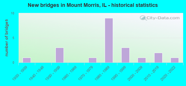
- New bridges - historical statistics
- 11930-1939
- 31950-1959
- 11970-1979
- 91980-1989
- 31990-1999
- 12000-2009
- 22010-2019
- 12020-2022


- Bridge Condition - Deck
- 38.5%Very good
- 7.7%Good
- 23.1%Satisfactory
- 23.1%Fair
- 7.7%Poor

- Bridge Condition - Superstructure
- 30.8%Very good
- 7.7%Good
- 30.8%Satisfactory
- 23.1%Fair
- 7.7%Poor

- Bridge Condition - Substructure
- 7.7%Very good
- 61.5%Good
- 30.8%Satisfactory

- Bridge Condition - Channel
- 5.3%Excellent
- 26.3%Very good
- 21.1%Good
- 47.4%Satisfactory

- Bridge Condition - Culverts
- 12.5%Excellent
- 50.0%Very good
- 25.0%Good
- 12.5%Satisfactory
Find on map >> Show street view
Structure Number: 710015, Location: 5.7 MI E JCT ILL 26 (Lat: 42.048831, Lng: -89.477239), Route carried "on" structure: State highway 64, Year Built: 1955, Status: Open, Structure Length: 1.40m (4.59ft), Average Daily Traffic: 1,400 (year 2021), Truck Traffic: 13%, Average Future Daily Traffic: 1,600 (year 2040), Design Load: HS 20, Features Intersected: DRAINAGE DITCH
Minimum Vertical Clearance: 30+ m (98+ ft), Kilometerpoint: 64.195, Lanes on structure: 2, Base Highway Network: Yes, Owner: State Highway Agency, Approaching Roadway Width: 9.1m (29.9ft), Skew: 2 degrees, Material/Design: Concrete continuous, Design/Construction: Slab, Number Of Spans In Main Unit: 2, Length of Maximum Span: 6.7m (22.0ft), Curb-To-Curb Width: 12.3m (40.4ft), Out-to-Out Width: 12.9m (42.3ft)
Condition: Deck: Fair, Superstructure: Fair, Substructure: Satisfactory, Channel: Satisfactory, Operating Rating: 70.3 metric tons, Method Used To Determine Operating Rating: Load Factor (LF) rating reported by rating factor (RF) method using MS18 loading, Inventory Rating: 42.1 metric tons, Method Used To Determine Inventory Rating: Load Factor (LF) rating reported by rating factor (RF) method using MS18 loading, Structural Evaluation: Somewhat better than minimum adequacy, Deck Geometry: Better than present minimum criteria, Waterway Adequacy: Equal to present desirable criteria, Approach Roadway Alignment: Equal to present desirable criteria, Designated Inspection Frequency: Every 24 months, Inspection Date: November 2021, Deck Structure Type: Concrete Cast-file-Place, Wearing Surface/Protective System: Deck Protection: Epoxy Coated Reinforcing
Find on map >> Show street view
Structure Number: 713232, Location: 3.0 MI SW MT MORRIS (Lat: 42.011300, Lng: -89.461378), Route carried "on" structure: County highway , Year Built: 1979, Status: Open, Structure Length: 3.20m (10.50ft), Average Daily Traffic: 150 (year 2017), Truck Traffic: 11%, Average Future Daily Traffic: 300 (year 2040), Design Load: HS 20, Features Intersected: PINE CREEK, Facility Carried by Structure: OREGON TRAIL ROAD
Minimum Vertical Clearance: 30+ m (98+ ft), Kilometerpoint: 14.097, Lanes on structure: 2, Owner: Town or Township Highway Agency, Approaching Roadway Width: 8.5m (27.9ft), Material/Design: Prestressed concrete, Design/Construction: Box Beam or Girders - Multiple, Number Of Spans In Main Unit: 3, Length of Maximum Span: 10.4m (34.1ft), Curb-To-Curb Width: 7.3m (24.0ft), Out-to-Out Width: 7.3m (24.0ft)
Condition: Deck: Satisfactory, Superstructure: Satisfactory, Substructure: Good, Channel: Satisfactory, Operating Rating: 44.4 metric tons, Method Used To Determine Operating Rating: Assigned rating based on Load Factor Design (LFD) reported by rating factor (RF) using MS18 loading, Inventory Rating: 32.4 metric tons, Method Used To Determine Inventory Rating: Assigned rating based on Load Factor Design (LFD) reported by rating factor (RF) using MS18 loading, Structural Evaluation: Equal to present minimum criteria, Deck Geometry: Somewhat better than minimum adequacy, Waterway Adequacy: Superior to present desirable criteria, Approach Roadway Alignment: Equal to present desirable criteria, Designated Inspection Frequency: Every 24 months, Inspection Date: August 2021, Deck Structure Type: Concrete Precast Panels
Find on map >> Show street view
Structure Number: 713251, Location: 7.0 MI E OF POLO (Lat: 41.981469, Lng: -89.443942), Route carried "on" structure: County highway , Year Built: 1985, Status: Open, Structure Length: 4.36m (14.30ft), Average Daily Traffic: 100 (year 2017), Average Future Daily Traffic: 75 (year 2040), Design Load: HS 20, Features Intersected: PINE CREEK, Facility Carried by Structure: COLUMBIAN ROAD
Minimum Vertical Clearance: 30+ m (98+ ft), Kilometerpoint: 11.587, Lanes on structure: 2, Owner: Town or Township Highway Agency, Approaching Roadway Width: 7.3m (24.0ft), Skew: 3 degrees, Material/Design: Prestressed concrete, Design/Construction: Box Beam or Girders - Multiple, Number Of Spans In Main Unit: 3, Length of Maximum Span: 14.3m (46.9ft), Curb-To-Curb Width: 7.3m (24.0ft), Out-to-Out Width: 7.3m (24.0ft)
Condition: Deck: Poor, Superstructure: Poor, Substructure: Good, Channel: Satisfactory, Operating Rating: 44.4 metric tons, Method Used To Determine Operating Rating: Assigned rating based on Load Factor Design (LFD) reported by rating factor (RF) using MS18 loading, Inventory Rating: 32.4 metric tons, Method Used To Determine Inventory Rating: Assigned rating based on Load Factor Design (LFD) reported by rating factor (RF) using MS18 loading, Structural Evaluation: Meets minimum limits, Deck Geometry: Equal to present minimum criteria, Waterway Adequacy: Equal to present desirable criteria, Approach Roadway Alignment: Equal to present desirable criteria, Designated Inspection Frequency: Every 24 months, Inspection Date: August 2021, Deck Structure Type: Concrete Precast Panels
Find on map >> Show street view
Structure Number: 71326, Location: 2.5 MI NE MT MORRIS (Lat: 42.071828, Lng: -89.394531), Route carried "on" structure: County highway , Year Built: 1982, Status: Open, Structure Length: 0.85m (2.79ft), Average Daily Traffic: 150 (year 2017), Truck Traffic: 5%, Average Future Daily Traffic: 350 (year 2040), Design Load: HS 20, Features Intersected: BRANCH SILVER CREEK, Facility Carried by Structure: MIDTOWN RD - TR 16
Minimum Vertical Clearance: 30+ m (98+ ft), Kilometerpoint: 8.256, Lanes on structure: 2, Owner: Town or Township Highway Agency, Approaching Roadway Width: 8.5m (27.9ft), Material/Design: Concrete, Design/Construction: Channel Beam, Number Of Spans In Main Unit: 1, Length of Maximum Span: 7.3m (24.0ft), Curb-To-Curb Width: 8.0m (26.2ft), Out-to-Out Width: 8.0m (26.2ft)
Condition: Deck: Very good, Superstructure: Very good, Substructure: Good, Channel: Good, Operating Rating: 44.4 metric tons, Method Used To Determine Operating Rating: Assigned rating based on Load Factor Design (LFD) reported by rating factor (RF) using MS18 loading, Inventory Rating: 32.4 metric tons, Method Used To Determine Inventory Rating: Assigned rating based on Load Factor Design (LFD) reported by rating factor (RF) using MS18 loading, Structural Evaluation: Better than present minimum criteria, Deck Geometry: Somewhat better than minimum adequacy, Waterway Adequacy: Equal to present desirable criteria, Approach Roadway Alignment: Equal to present desirable criteria, Designated Inspection Frequency: Every 48 months, Inspection Date: August 2021, Deck Structure Type: Concrete Precast Panels, Wearing Surface/Protective System: Wearing Surface: Bituminous
Find on map >> Show street view
Structure Number: 713273, Location: 5.5 MI E OF POLO (Lat: 41.988728, Lng: -89.463064), Route carried "on" structure: County highway , Year Built: 1984, Status: Open, Structure Length: 2.50m (8.20ft), Average Daily Traffic: 2,100 (year 2017), Truck Traffic: 7%, Average Future Daily Traffic: 2,700 (year 2040), Design Load: HS 20, Features Intersected: PINE CREEK, Facility Carried by Structure: PINES ROAD
Minimum Vertical Clearance: 30+ m (98+ ft), Kilometerpoint: 9.575, Lanes on structure: 2, Owner: County Highway Agency, Approaching Roadway Width: 12.2m (40.0ft), Material/Design: Concrete, Design/Construction: Girder and Floorbeam System, Number Of Spans In Main Unit: 1, Length of Maximum Span: 23.5m (77.1ft), Curb-To-Curb Width: 12.2m (40.0ft), Out-to-Out Width: 12.2m (40.0ft)
Condition: Deck: Very good, Superstructure: Very good, Substructure: Good, Channel: Very good, Operating Rating: 44.4 metric tons, Method Used To Determine Operating Rating: Assigned rating based on Load Factor Design (LFD) reported by rating factor (RF) using MS18 loading, Inventory Rating: 32.4 metric tons, Method Used To Determine Inventory Rating: Assigned rating based on Load Factor Design (LFD) reported by rating factor (RF) using MS18 loading, Structural Evaluation: Better than present minimum criteria, Deck Geometry: Equal to present minimum criteria, Waterway Adequacy: Superior to present desirable criteria, Approach Roadway Alignment: Equal to present desirable criteria, Designated Inspection Frequency: Every 24 months, Inspection Date: August 2021, Deck Structure Type: Concrete Cast-file-Place
Find on map >> Show street view
Structure Number: 713275, Location: 2.5 M E MT MORRIS (Lat: 42.046325, Lng: -89.383453), Route carried "on" structure: County highway , Year Built: 1983, Status: Open, Structure Length: 1.71m (5.61ft), Average Daily Traffic: 350 (year 2017), Truck Traffic: 10%, Average Future Daily Traffic: 550 (year 2040), Design Load: HS 20, Features Intersected: MUD CREEK, Facility Carried by Structure: ROCK ROAD
Minimum Vertical Clearance: 30+ m (98+ ft), Kilometerpoint: 0.435, Lanes on structure: 2, Owner: Town or Township Highway Agency, Approaching Roadway Width: 9.1m (29.9ft), Material/Design: Prestressed concrete, Design/Construction: Box Beam or Girders - Multiple, Number Of Spans In Main Unit: 1, Length of Maximum Span: 16.5m (54.1ft), Curb-To-Curb Width: 7.3m (24.0ft), Out-to-Out Width: 7.3m (24.0ft)
Condition: Deck: Fair, Superstructure: Fair, Substructure: Good, Channel: Good, Operating Rating: 44.4 metric tons, Method Used To Determine Operating Rating: Assigned rating based on Load Factor Design (LFD) reported by rating factor (RF) using MS18 loading, Inventory Rating: 32.4 metric tons, Method Used To Determine Inventory Rating: Assigned rating based on Load Factor Design (LFD) reported by rating factor (RF) using MS18 loading, Structural Evaluation: Somewhat better than minimum adequacy, Deck Geometry: Somewhat better than minimum adequacy, Waterway Adequacy: Superior to present desirable criteria, Approach Roadway Alignment: Equal to present desirable criteria, Designated Inspection Frequency: Every 24 months, Inspection Date: August 2021, Deck Structure Type: Concrete Precast Panels, Wearing Surface/Protective System: Wearing Surface: Bituminous
Find on map >> Show street view
Structure Number: 713276, Location: 4.3 MI E OF HALDANE (Lat: 42.063244, Lng: -89.484578), Route carried "on" structure: County highway , Year Built: 1984, Status: Open, Structure Length: 1.62m (5.31ft), Average Daily Traffic: 125 (year 2017), Truck Traffic: 14%, Average Future Daily Traffic: 250 (year 2040), Design Load: HS 20, Features Intersected: BR. PINE CREEK, Facility Carried by Structure: HALDANE ROAD
Minimum Vertical Clearance: 30+ m (98+ ft), Kilometerpoint: 6.904, Lanes on structure: 2, Owner: Town or Township Highway Agency, Approaching Roadway Width: 7.3m (24.0ft), Skew: 1 degrees, Material/Design: Prestressed concrete, Design/Construction: Box Beam or Girders - Multiple, Number Of Spans In Main Unit: 1, Length of Maximum Span: 15.2m (49.9ft), Curb-To-Curb Width: 7.3m (24.0ft), Out-to-Out Width: 7.3m (24.0ft)
Condition: Deck: Satisfactory, Superstructure: Satisfactory, Substructure: Good, Channel: Satisfactory, Operating Rating: 44.4 metric tons, Method Used To Determine Operating Rating: Assigned rating based on Load Factor Design (LFD) reported by rating factor (RF) using MS18 loading, Inventory Rating: 32.4 metric tons, Method Used To Determine Inventory Rating: Assigned rating based on Load Factor Design (LFD) reported by rating factor (RF) using MS18 loading, Structural Evaluation: Equal to present minimum criteria, Deck Geometry: Somewhat better than minimum adequacy, Waterway Adequacy: Equal to present desirable criteria, Approach Roadway Alignment: Equal to present desirable criteria, Designated Inspection Frequency: Every 24 months, Inspection Date: August 2021, Deck Structure Type: Concrete Precast Panels
Find on map >> Show street view
Structure Number: 71328, Location: 2.5 MI SW MT MORRIS (Lat: 42.027822, Lng: -89.474597), Route carried "on" structure: County highway , Year Built: 1984, Status: Open, Structure Length: 2.01m (6.59ft), Average Daily Traffic: 1,000 (year 2017), Truck Traffic: 10%, Average Future Daily Traffic: 1,000 (year 2040), Design Load: HS 20, Features Intersected: PINE CREEK, Facility Carried by Structure: LOWELL PARK ROAD
Minimum Vertical Clearance: 30+ m (98+ ft), Kilometerpoint: 4.844, Lanes on structure: 2, Owner: County Highway Agency, Approaching Roadway Width: 10.4m (34.1ft), Material/Design: Prestressed concrete, Design/Construction: Box Beam or Girders - Multiple, Number Of Spans In Main Unit: 1, Length of Maximum Span: 19.5m (64.0ft), Curb-To-Curb Width: 10.4m (34.1ft), Out-to-Out Width: 10.4m (34.1ft)
Condition: Deck: Good, Superstructure: Good, Substructure: Satisfactory, Channel: Very good, Operating Rating: 44.4 metric tons, Method Used To Determine Operating Rating: Assigned rating based on Load Factor Design (LFD) reported by rating factor (RF) using MS18 loading, Inventory Rating: 32.4 metric tons, Method Used To Determine Inventory Rating: Assigned rating based on Load Factor Design (LFD) reported by rating factor (RF) using MS18 loading, Structural Evaluation: Equal to present minimum criteria, Deck Geometry: Equal to present minimum criteria, Waterway Adequacy: Superior to present desirable criteria, Approach Roadway Alignment: Equal to present desirable criteria, Designated Inspection Frequency: Every 24 months, Inspection Date: August 2021, Deck Structure Type: Concrete Precast Panels, Wearing Surface/Protective System: Wearing Surface: Bituminous, Membrane: Built-up
Find on map >> Show street view
Structure Number: 713288, Location: 3.5 M NW MT MORRIS (Lat: 42.077831, Lng: -89.487569), Route carried "on" structure: County highway , Year Built: 1986, Status: Open, Structure Length: 0.98m (3.22ft), Average Daily Traffic: 25 (year 2017), Average Future Daily Traffic: 50 (year 2040), Design Load: HS 20, Features Intersected: BR OF PINE CREEK, Facility Carried by Structure: APPLE ROAD
Minimum Vertical Clearance: 30+ m (98+ ft), Kilometerpoint: 6.679, Lanes on structure: 2, Owner: Town or Township Highway Agency, Approaching Roadway Width: 9.1m (29.9ft), Material/Design: Concrete, Design/Construction: Channel Beam, Number Of Spans In Main Unit: 1, Length of Maximum Span: 8.8m (28.9ft), Curb-To-Curb Width: 8.0m (26.2ft), Out-to-Out Width: 8.0m (26.2ft)
Condition: Deck: Very good, Superstructure: Very good, Substructure: Good, Channel: Satisfactory, Operating Rating: 44.4 metric tons, Method Used To Determine Operating Rating: Assigned rating based on Load Factor Design (LFD) reported by rating factor (RF) using MS18 loading, Inventory Rating: 32.4 metric tons, Method Used To Determine Inventory Rating: Assigned rating based on Load Factor Design (LFD) reported by rating factor (RF) using MS18 loading, Structural Evaluation: Better than present minimum criteria, Deck Geometry: Equal to present minimum criteria, Waterway Adequacy: Superior to present desirable criteria, Approach Roadway Alignment: Equal to present desirable criteria, Designated Inspection Frequency: Every 48 months, Inspection Date: August 2021, Deck Structure Type: Concrete Precast Panels
Find on map >> Show street view
Structure Number: 713303, Location: 3 MI. W. OF OREGON (Lat: 41.993097, Lng: -89.404747), Route carried "on" structure: County highway , Year Built: 1991, Status: Open, Structure Length: 3.98m (13.06ft), Average Daily Traffic: 3,050 (year 2017), Truck Traffic: 9%, Average Future Daily Traffic: 2,500 (year 2040), Design Load: HS 20, Features Intersected: BNSF RR, Facility Carried by Structure: RIDGE RD (FAS 85)
Minimum Vertical Clearance: 30+ m (98+ ft), Kilometerpoint: 14.902, Lanes on structure: 2, Owner: County Highway Agency, Approaching Roadway Width: 12.2m (40.0ft), Material/Design: Prestressed concrete, Design/Construction: Box Beam or Girders - Multiple, Number Of Spans In Main Unit: 3, Length of Maximum Span: 13.1m (43.0ft), Curb-To-Curb Width: 9.1m (29.9ft), Out-to-Out Width: 9.1m (29.9ft)
Condition: Deck: Fair, Superstructure: Fair, Substructure: Satisfactory, Operating Rating: 44.4 metric tons, Method Used To Determine Operating Rating: Assigned rating based on Load Factor Design (LFD) reported by rating factor (RF) using MS18 loading, Inventory Rating: 32.4 metric tons, Method Used To Determine Inventory Rating: Assigned rating based on Load Factor Design (LFD) reported by rating factor (RF) using MS18 loading, Structural Evaluation: Somewhat better than minimum adequacy, Deck Geometry: Meets minimum limits, Underclear: Somewhat better than minimum adequacy, Approach Roadway Alignment: Equal to present desirable criteria, Designated Inspection Frequency: Every 24 months, Inspection Date: August 2021, Deck Structure Type: Concrete Precast Panels, Wearing Surface/Protective System: Wearing Surface: Bituminous, Membrane: Built-up
Find on map >> Show street view
Structure Number: 713346, Location: 3 MI SW OF MT MORRIS (Lat: 42.039831, Lng: -89.496308), Route carried "on" structure: County highway , Year Built: 2014, Status: Open, Structure Length: 1.45m (4.76ft), Average Daily Traffic: 50 (year 2017), Average Future Daily Traffic: 55 (year 2033), Design Load: HS 25 or greater, Features Intersected: PINE CREEK, Facility Carried by Structure: MAPLE GROVE ROAD
Minimum Vertical Clearance: 30+ m (98+ ft), Kilometerpoint: 0.982, Lanes on structure: 2, Owner: Town or Township Highway Agency, Approaching Roadway Width: 7.3m (24.0ft), Skew: 3 degrees, Material/Design: Prestressed concrete, Design/Construction: Box Beam or Girders - Multiple, Number Of Spans In Main Unit: 1, Length of Maximum Span: 13.3m (43.6ft), Curb-To-Curb Width: 9.1m (29.9ft), Out-to-Out Width: 9.1m (29.9ft)
Condition: Deck: Very good, Superstructure: Very good, Substructure: Good, Channel: Very good, Operating Rating: 42.1 metric tons, Method Used To Determine Operating Rating: Assigned ratings based on Load and Resistance Factor Design (LRFD) reported by rating factor (RF) using HL93 loadings, Inventory Rating: 32.4 metric tons, Method Used To Determine Inventory Rating: Assigned ratings based on Load and Resistance Factor Design (LRFD) reported by rating factor (RF) using HL93 loadings, Structural Evaluation: Better than present minimum criteria, Deck Geometry: Better than present minimum criteria, Waterway Adequacy: Better than present minimum criteria, Approach Roadway Alignment: Equal to present desirable criteria, Designated Inspection Frequency: Every 48 months, Inspection Date: August 2021, Deck Structure Type: Concrete Precast Panels, Wearing Surface/Protective System: Wearing Surface: Integral Concrete, Deck Protection: Epoxy Coated Reinforcing
Find on map >> Show street view
Structure Number: 715022, Location: 3.5 S. LEAF RIVER (Lat: 42.066822, Lng: -89.403211), Route carried "on" structure: County highway , Year Built: 1957, Status: Open, Structure Length: 0.78m (2.56ft), Average Daily Traffic: 425 (year 2017), Truck Traffic: 9%, Average Future Daily Traffic: 450 (year 2040), Design Load: HS 15, Features Intersected: BR. SILVER CREEK, Facility Carried by Structure: LEAF RIVER RD.
Minimum Vertical Clearance: 30+ m (98+ ft), Kilometerpoint: 3.058, Lanes on structure: 2, Owner: Town or Township Highway Agency, Approaching Roadway Width: 7.3m (24.0ft), Material/Design: Concrete, Design/Construction: Culvert, Number Of Spans In Main Unit: 2, Length of Maximum Span: 3.7m (12.1ft)
Condition: Channel: Satisfactory, Culverts: Satisfactory, Operating Rating: 40.5 metric tons, Method Used To Determine Operating Rating: Field evaluation and documented engineering judgment, Inventory Rating: 24.3 metric tons, Method Used To Determine Inventory Rating: Field evaluation and documented engineering judgment, Structural Evaluation: Equal to present minimum criteria, Waterway Adequacy: Equal to present desirable criteria, Approach Roadway Alignment: Equal to present desirable criteria, Designated Inspection Frequency: Every 24 months, Inspection Date: August 2021
Find on map >> Show street view
Structure Number: 715027, Location: 2.5 W. OREGON (Lat: 42.017997, Lng: -89.388569), Route carried "on" structure: County highway , Year Built: 1957, Status: Open, Structure Length: 0.88m (2.89ft), Average Daily Traffic: 800 (year 2012), Truck Traffic: 1%, Average Future Daily Traffic: 1,200 (year 2040), Design Load: HS 15, Features Intersected: GALE CREEK, Facility Carried by Structure: OREGON TRAIL RD.
Minimum Vertical Clearance: 30+ m (98+ ft), Kilometerpoint: 3.170, Lanes on structure: 2, Owner: Town or Township Highway Agency, Approaching Roadway Width: 7.3m (24.0ft), Material/Design: Concrete, Design/Construction: Culvert, Number Of Spans In Main Unit: 3, Length of Maximum Span: 2.7m (8.9ft)
Condition: Channel: Good, Culverts: Good, Operating Rating: 40.5 metric tons, Method Used To Determine Operating Rating: Field evaluation and documented engineering judgment, Inventory Rating: 24.3 metric tons, Method Used To Determine Inventory Rating: Field evaluation and documented engineering judgment, Structural Evaluation: Equal to present minimum criteria, Waterway Adequacy: Equal to present minimum criteria, Approach Roadway Alignment: Equal to present minimum criteria, Designated Inspection Frequency: Every 24 months, Inspection Date: August 2021
Find on map >> Show street view
Structure Number: 715073, Location: NORTH EDGE MT MORRIS (Lat: 42.057539, Lng: -89.432250), Route carried "on" structure: County highway , Year Built: 1980, Status: Open, Structure Length: 0.79m (2.59ft), Average Daily Traffic: 1,700 (year 2017), Truck Traffic: 12%, Average Future Daily Traffic: 1,800 (year 2040), Design Load: HS 20, Features Intersected: UNNAMED STREAM, Facility Carried by Structure: MOUNT MORRIS ROAD
Minimum Vertical Clearance: 30+ m (98+ ft), Kilometerpoint: 7.177, Lanes on structure: 2, Owner: City or Municipal Highway Agency, Approaching Roadway Width: 11.0m (36.1ft), Material/Design: Concrete, Design/Construction: Culvert, Number Of Spans In Main Unit: 2, Length of Maximum Span: 3.7m (12.1ft), Curb-To-Curb Width: 11.0m (36.1ft), Out-to-Out Width: 13.8m (45.3ft)
Condition: Channel: Satisfactory, Culverts: Good, Operating Rating: 44.4 metric tons, Method Used To Determine Operating Rating: Assigned rating based on Load Factor Design (LFD) reported by rating factor (RF) using MS18 loading, Inventory Rating: 32.4 metric tons, Method Used To Determine Inventory Rating: Assigned rating based on Load Factor Design (LFD) reported by rating factor (RF) using MS18 loading, Structural Evaluation: Better than present minimum criteria, Deck Geometry: Equal to present minimum criteria, Waterway Adequacy: Equal to present desirable criteria, Approach Roadway Alignment: Equal to present desirable criteria, Designated Inspection Frequency: Every 48 months, Inspection Date: August 2020
Find on map >> Show street view
Structure Number: 715082, Location: 7 MI. E. POLO (Lat: 41.988861, Lng: -89.436764), Route carried "on" structure: County highway , Year Built: 1990, Status: Open, Structure Length: 1.17m (3.84ft), Average Daily Traffic: 2,100 (year 2017), Truck Traffic: 7%, Average Future Daily Traffic: 2,700 (year 2040), Design Load: HS 20, Features Intersected: BR. PINE CREEK, Facility Carried by Structure: PINES ROAD
Minimum Vertical Clearance: 30+ m (98+ ft), Kilometerpoint: 11.764, Lanes on structure: 2, Owner: County Highway Agency, Approaching Roadway Width: 12.2m (40.0ft), Material/Design: Concrete, Design/Construction: Culvert, Number Of Spans In Main Unit: 3, Length of Maximum Span: 3.8m (12.5ft)
Condition: Channel: Satisfactory, Culverts: Very good, Operating Rating: 44.4 metric tons, Method Used To Determine Operating Rating: Assigned rating based on Load Factor Design (LFD) reported by rating factor (RF) using MS18 loading, Inventory Rating: 32.4 metric tons, Method Used To Determine Inventory Rating: Assigned rating based on Load Factor Design (LFD) reported by rating factor (RF) using MS18 loading, Structural Evaluation: Equal to present desirable criteria, Waterway Adequacy: Equal to present desirable criteria, Approach Roadway Alignment: Equal to present desirable criteria, Designated Inspection Frequency: Every 48 months, Inspection Date: August 2021
Find on map >> Show street view
Structure Number: 715096, Location: 3.5 MI SW MT. MORRIS (Lat: 42.013008, Lng: -89.481514), Route carried "on" structure: County highway , Year Built: 1995, Status: Open, Structure Length: 1.00m (3.28ft), Average Daily Traffic: 825 (year 2017), Truck Traffic: 8%, Average Future Daily Traffic: 900 (year 2040), Design Load: HS 20, Features Intersected: BR. PINE CREEK, Facility Carried by Structure: LOWELL PARK ROAD
Minimum Vertical Clearance: 30+ m (98+ ft), Kilometerpoint: 6.872, Lanes on structure: 2, Owner: County Highway Agency, Approaching Roadway Width: 9.1m (29.9ft), Material/Design: Concrete, Design/Construction: Culvert, Number Of Spans In Main Unit: 3, Length of Maximum Span: 3.0m (9.8ft)
Condition: Channel: Satisfactory, Culverts: Very good, Operating Rating: 44.1 metric tons, Method Used To Determine Operating Rating: Assigned rating based on Load Factor Design (LFD) reported by rating factor (RF) using MS18 loading, Inventory Rating: 32.4 metric tons, Method Used To Determine Inventory Rating: Assigned rating based on Load Factor Design (LFD) reported by rating factor (RF) using MS18 loading, Structural Evaluation: Equal to present desirable criteria, Waterway Adequacy: Superior to present desirable criteria, Approach Roadway Alignment: Equal to present desirable criteria, Designated Inspection Frequency: Every 48 months, Inspection Date: August 2021
Find on map >> Show street view
Structure Number: 715121, Location: SW EDGE OF MT MORRIS (Lat: 42.040903, Lng: -89.431917), Route carried "on" structure: County highway , Year Built: 2005, Status: Open, Structure Length: 0.72m (2.36ft), Average Daily Traffic: 475 (year 2017), Truck Traffic: 8%, Average Future Daily Traffic: 500 (year 2040), Design Load: HS 20, Features Intersected: UNNAMED CREEK, Facility Carried by Structure: LOWELL PARK ROAD
Minimum Vertical Clearance: 30+ m (98+ ft), Kilometerpoint: 9.012, Lanes on structure: 2, Owner: County Highway Agency, Approaching Roadway Width: 11.0m (36.1ft), Material/Design: Concrete, Design/Construction: Culvert, Number Of Spans In Main Unit: 2, Length of Maximum Span: 3.4m (11.2ft)
Condition: Channel: Very good, Culverts: Very good, Operating Rating: 44.1 metric tons, Method Used To Determine Operating Rating: Assigned rating based on Load Factor Design (LFD) reported by rating factor (RF) using MS18 loading, Inventory Rating: 32.4 metric tons, Method Used To Determine Inventory Rating: Assigned rating based on Load Factor Design (LFD) reported by rating factor (RF) using MS18 loading, Structural Evaluation: Equal to present desirable criteria, Waterway Adequacy: Superior to present desirable criteria, Approach Roadway Alignment: Equal to present desirable criteria, Designated Inspection Frequency: Every 48 months, Inspection Date: August 2021
Find on map >> Show street view
Structure Number: 715127, Location: 1.5 NW OF MT MORRIS (Lat: 42.063486, Lng: -89.466692), Route carried "on" structure: County highway , Year Built: 2013, Status: Open, Structure Length: 1.12m (3.67ft), Average Daily Traffic: 125 (year 2017), Truck Traffic: 14%, Average Future Daily Traffic: 100 (year 2032), Design Load: HS 25 or greater, Features Intersected: BR PINE CREEK, Facility Carried by Structure: HALDANE RD
Minimum Vertical Clearance: 30+ m (98+ ft), Kilometerpoint: 8.352, Lanes on structure: 2, Owner: Town or Township Highway Agency, Approaching Roadway Width: 9.1m (29.9ft), Skew: 1 degrees, Material/Design: Concrete, Design/Construction: Culvert, Number Of Spans In Main Unit: 3, Length of Maximum Span: 3.4m (11.2ft), Curb-To-Curb Width: 9.1m (29.9ft), Out-to-Out Width: 9.8m (32.2ft)
Condition: Channel: Good, Culverts: Very good, Operating Rating: 42.1 metric tons, Method Used To Determine Operating Rating: Assigned ratings based on Load and Resistance Factor Design (LRFD) reported by rating factor (RF) using HL93 loadings, Inventory Rating: 32.4 metric tons, Method Used To Determine Inventory Rating: Assigned ratings based on Load and Resistance Factor Design (LRFD) reported by rating factor (RF) using HL93 loadings, Structural Evaluation: Equal to present desirable criteria, Deck Geometry: Equal to present minimum criteria, Waterway Adequacy: Superior to present desirable criteria, Approach Roadway Alignment: Superior to present desirable criteria, Designated Inspection Frequency: Every 48 months, Inspection Date: October 2019, Deck Structure Type: Concrete Cast-file-Place, Wearing Surface/Protective System: Deck Protection: Epoxy Coated Reinforcing
Find on map >> Show street view
Structure Number: 715131, Location: 3.0 SW MT MORRIS (Lat: 42.037242, Lng: -89.496236), Route carried "on" structure: County highway , Year Built: 2021, Status: Open, Structure Length: 1.23m (4.04ft), Average Daily Traffic: 50 (year 2017), Average Future Daily Traffic: 65 (year 2030), Design Load: HS 25 or greater, Features Intersected: BR PINE CREEK, Facility Carried by Structure: TR114 MAPLE GROVE
Minimum Vertical Clearance: 30+ m (98+ ft), Kilometerpoint: 1.271, Lanes on structure: 2, Owner: Town or Township Highway Agency, Approaching Roadway Width: 9.1m (29.9ft), Material/Design: Concrete continuous, Design/Construction: Culvert, Number Of Spans In Main Unit: 3, Length of Maximum Span: 0.0m
Condition: Channel: Excellent, Culverts: Excellent, Operating Rating: 51.2 metric tons, Method Used To Determine Operating Rating: Load and Resistance Factor Rating (LRFR) rating reported by rating factor(RF) method using HL-93 loadings, Inventory Rating: 39.5 metric tons, Method Used To Determine Inventory Rating: Load and Resistance Factor Rating (LRFR) rating reported by rating factor(RF) method using HL-93 loadings, Structural Evaluation: Superior to present desirable criteria, Waterway Adequacy: Superior to present desirable criteria, Approach Roadway Alignment: Equal to present desirable criteria, Designated Inspection Frequency: Every 24 months, Inspection Date: August 2021, Wearing Surface/Protective System: Wearing Surface: Bituminous, Membrane: Built-up, Deck Protection: Epoxy Coated Reinforcing
Find on map >> Show street view
Structure Number: 719912, Location: 3 MI S MT MORRIS (Lat: 41.996756, Lng: -89.448317), Route carried "on" structure: County highway , Year Built: 1930, Status: Open, Structure Length: 3.20m (10.50ft), Average Daily Traffic: 125 (year 2017), Truck Traffic: 10%, Average Future Daily Traffic: 300 (year 2040), Features Intersected: BNSF RR, Facility Carried by Structure: COLUMBIAN RD
Minimum Vertical Clearance: 30+ m (98+ ft), Kilometerpoint: 13.695, Lanes on structure: 2, Owner: Railroad, Approaching Roadway Width: 6.1m (20.0ft), Skew: 1 degrees, Material/Design: Wood or Timber, Design/Construction: Stringer/Multi-beam, Number Of Spans In Main Unit: 7, Length of Maximum Span: 6.7m (22.0ft), Curb-To-Curb Width: 6.1m (20.0ft), Out-to-Out Width: 6.7m (22.0ft)
Condition: Deck: Very good, Superstructure: Satisfactory, Substructure: Satisfactory, Operating Rating: 31.4 metric tons, Method Used To Determine Operating Rating: Allowable Stress (AS) rating reported by rating factor (RF) method using MS18 loading, Inventory Rating: 23.3 metric tons, Method Used To Determine Inventory Rating: Allowable Stress (AS) rating reported by rating factor (RF) method using MS18 loading, Structural Evaluation: Equal to present minimum criteria, Deck Geometry: Meets minimum limits, Underclear: Somewhat better than minimum adequacy, Approach Roadway Alignment: Equal to present minimum criteria, Designated Inspection Frequency: Every 24 months, Inspection Date: August 2021, Deck Structure Type: Wood or Timber, Wearing Surface/Protective System: Wearing Surface: Wood or Timber
Find on map >> Show street view
Structure Number: 719924, Location: .14 MI N. PINES ROAD (Lat: 41.990614, Lng: -89.466711), Route carried "on" structure: Other road , Year Built: 1984, Status: Open, Structure Length: 1.83m (6.00ft), Average Daily Traffic: 475 (year 2017), Truck Traffic: 10%, Average Future Daily Traffic: 250 (year 2040), Design Load: HS 20, Features Intersected: PINES CREEK, Facility Carried by Structure: WH. PINES PK RD /O
Minimum Vertical Clearance: 30+ m (98+ ft), Kilometerpoint: 0.692, Lanes on structure: 2, Owner: State Park, Forest, or Reservation Agency, Approaching Roadway Width: 6.1m (20.0ft), Material/Design: Prestressed concrete, Design/Construction: Box Beam or Girders - Multiple, Number Of Spans In Main Unit: 1, Length of Maximum Span: 17.8m (58.4ft), Curb or Sidewalk Widths: Left: 0.0m, Right: 1.7m (5.6ft), Curb-To-Curb Width: 7.3m (24.0ft), Out-to-Out Width: 9.2m (30.2ft)
Condition: Deck: Satisfactory, Superstructure: Satisfactory, Substructure: Very good, Channel: Very good, Operating Rating: 54.1 metric tons, Method Used To Determine Operating Rating: Field evaluation and documented engineering judgment, Inventory Rating: 32.4 metric tons, Method Used To Determine Inventory Rating: Field evaluation and documented engineering judgment, Structural Evaluation: Equal to present minimum criteria, Deck Geometry: Meets minimum limits, Waterway Adequacy: Equal to present desirable criteria, Approach Roadway Alignment: Equal to present desirable criteria, Designated Inspection Frequency: Every 24 months, Inspection Date: November 2019, Deck Structure Type: Concrete Precast Panels, Wearing Surface/Protective System: Wearing Surface: Bituminous