Bridge Statistics for Mount Cobb, Pennsylvania (PA)
Condition, Traffic, Stress, Structural Evaluation, Project Costs
- National Bridge Inventory (NBI) Statistics
- 39Number of bridges
- 256ft / 78.2mTotal length
- $9,705,000Total costs
- 141,417Total average daily traffic
- 39,348Total average daily truck traffic
- National Bridge Inventory (NBI) Registered Bridges for Mount Cobb
- No street view available for this location
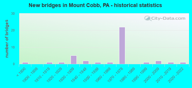
- New bridges - historical statistics
- 1Before 1900
- 11910-1919
- 11920-1929
- 51930-1939
- 21940-1949
- 11950-1959
- 11960-1969
- 221970-1979
- 11990-1999
- 22000-2009
- 12010-2019
- 12020-2022

- Reconstructed bridges - Historical Statistics
- 11960-1969
- 01970-1979
- 01980-1989
- 21990-1999


- Bridge Condition - Deck
- 10.5%Very good
- 21.1%Good
- 36.8%Satisfactory
- 31.6%Fair

- Bridge Condition - Superstructure
- 13.0%Very good
- 4.3%Good
- 17.4%Satisfactory
- 43.5%Fair
- 17.4%Poor
- 4.3%Serious

- Bridge Condition - Substructure
- 8.7%Very good
- 4.3%Good
- 43.5%Satisfactory
- 30.4%Fair
- 8.7%Poor
- 4.3%Critical

- Bridge Condition - Channel
- 5.3%Very good
- 10.5%Good
- 31.6%Satisfactory
- 31.6%Fair
- 21.1%Poor

- Bridge Condition - Culverts
- 50.0%Good
- 50.0%Satisfactory
Find on map >> Show street view
Structure Number: 20509, Location: JEFFERSON TWP .9M W TR247 (Lat: 41.404761, Lng: -75.519547), Route carried "on" structure: Interstate 84, Year Built: 1977, Status: Open, Structure Length: 3.44m (11.29ft), Average Daily Traffic: 7,962 (year 2021), Truck Traffic: 40%, Average Future Daily Traffic: 11,174 (year 2032), Design Load: HS 20+Mod, Features Intersected: T-334 GOLF CLUB ROAD
Minimum Vertical Clearance: 30+ m (98+ ft), Kilometerpoint: 13.102, Lanes on structure: 3, Lanes under structure: 2, Base Highway Network: Yes, Owner: State Highway Agency, Approaching Roadway Width: 14.0m (45.9ft), Skew: 10 degrees, Material/Design: Prestressed concrete, Design/Construction: Box Beam or Girders - Single/Spread, Number Of Spans In Main Unit: 3, Length of Maximum Span: 15.8m (51.8ft), Curb or Sidewalk Widths: Left: 0.2m (0.7ft), Right: 0.2m (0.7ft), Curb-To-Curb Width: 15.8m (51.8ft), Out-to-Out Width: 16.9m (55.4ft)
Condition: Deck: Satisfactory, Superstructure: Satisfactory, Substructure: Satisfactory, Operating Rating: 68.9 metric tons, Method Used To Determine Operating Rating: Load Factor (LF), Inventory Rating: 35.4 metric tons, Method Used To Determine Inventory Rating: Load Factor (LF), Structural Evaluation: Equal to present minimum criteria, Deck Geometry: Somewhat better than minimum adequacy, Underclear: Better than present minimum criteria, Approach Roadway Alignment: Equal to present desirable criteria, Length Of Structure Improvement: 3.40m (11.15ft), Designated Inspection Frequency: Every 24 months, Inspection Date: March 2021, Bridge Improvement Cost: $51,000, Roadway Improvement Cost: $151,000, Total Project Cost: $691,000, Deck Structure Type: Concrete Cast-file-Place, Wearing Surface/Protective System: Wearing Surface: Latex Concrete, Deck Protection: Epoxy Coated Reinforcing
Find on map >> Show street view
Structure Number: 2051, Location: JEFFERSON TWP .9M W TR247 (Lat: 41.405014, Lng: -75.519661), Route carried "on" structure: Interstate 84, Year Built: 1977, Status: Open, Structure Length: 3.57m (11.71ft), Average Daily Traffic: 8,658 (year 2021), Truck Traffic: 35%, Average Future Daily Traffic: 11,541 (year 2032), Design Load: HS 20+Mod, Features Intersected: T-334 GOLF CLUB ROAD
Minimum Vertical Clearance: 30+ m (98+ ft), Kilometerpoint: 12.143, Lanes on structure: 2, Lanes under structure: 2, Base Highway Network: Yes, Owner: State Highway Agency, Approaching Roadway Width: 11.6m (38.1ft), Skew: 10 degrees, Material/Design: Prestressed concrete, Design/Construction: Box Beam or Girders - Single/Spread, Number Of Spans In Main Unit: 3, Length of Maximum Span: 15.8m (51.8ft), Curb or Sidewalk Widths: Left: 0.2m (0.7ft), Right: 0.2m (0.7ft), Curb-To-Curb Width: 12.2m (40.0ft), Out-to-Out Width: 13.3m (43.6ft)
Condition: Deck: Satisfactory, Superstructure: Satisfactory, Substructure: Satisfactory, Operating Rating: 73.5 metric tons, Method Used To Determine Operating Rating: Load Factor (LF), Inventory Rating: 35.4 metric tons, Method Used To Determine Inventory Rating: Load Factor (LF), Structural Evaluation: Equal to present minimum criteria, Deck Geometry: Better than present minimum criteria, Underclear: Equal to present desirable criteria, Approach Roadway Alignment: Equal to present desirable criteria, Length Of Structure Improvement: 3.60m (11.81ft), Designated Inspection Frequency: Every 24 months, Inspection Date: March 2021, Bridge Improvement Cost: $41,000, Roadway Improvement Cost: $122,000, Total Project Cost: $557,000, Deck Structure Type: Concrete Cast-file-Place, Wearing Surface/Protective System: Wearing Surface: Latex Concrete, Deck Protection: Epoxy Coated Reinforcing
Find on map >> Show street view
Structure Number: 20511, Location: JEFFERSON TP 1.2M E TR247 (Lat: 41.398194, Lng: -75.484600), Route carried "on" structure: Interstate 84, Year Built: 1976, Status: Open, Structure Length: 0.64m (2.10ft), Average Daily Traffic: 15,034 (year 2021), Truck Traffic: 34%, Average Future Daily Traffic: 22,715 (year 2032), Design Load: HS 20, Features Intersected: RECREATIONAL TRAIL
Minimum Vertical Clearance: 30+ m (98+ ft), Kilometerpoint: 16.330, Lanes on structure: 2, Base Highway Network: Yes, Owner: State Highway Agency, Approaching Roadway Width: 7.3m (24.0ft), Skew: 21 degrees, Material/Design: Concrete, Design/Construction: Culvert, Number Of Spans In Main Unit: 1, Length of Maximum Span: 6.4m (21.0ft)
Condition: Culverts: Satisfactory, Operating Rating: 49.0 metric tons, Method Used To Determine Operating Rating: Field evaluation and documented engineering judgment, Inventory Rating: 32.7 metric tons, Method Used To Determine Inventory Rating: Field evaluation and documented engineering judgment, Structural Evaluation: Equal to present minimum criteria, Approach Roadway Alignment: Equal to present desirable criteria, Length Of Structure Improvement: 0.60m (1.97ft), Designated Inspection Frequency: Every 48 months, Inspection Date: March 2021, Bridge Improvement Cost: $30,000, Roadway Improvement Cost: $100,000, Total Project Cost: $402,000
Find on map >> Show street view
Structure Number: 20512, Location: JEFFERSON TWP OVR SR 2005 (Lat: 41.391536, Lng: -75.467839), Route carried "on" structure: Interstate 84, Year Built: 1976, Status: Open, Structure Length: 3.44m (11.29ft), Average Daily Traffic: 7,343 (year 2021), Truck Traffic: 33%, Average Future Daily Traffic: 11,174 (year 2032), Design Load: HS 20, Features Intersected: SR 2005
Minimum Vertical Clearance: 30+ m (98+ ft), Kilometerpoint: 17.939, Lanes on structure: 2, Lanes under structure: 2, Base Highway Network: Yes, Owner: State Highway Agency, Approaching Roadway Width: 11.6m (38.1ft), Skew: 10 degrees, Material/Design: Steel, Design/Construction: Stringer/Multi-beam, Number Of Spans In Main Unit: 1, Length of Maximum Span: 33.2m (108.9ft), Curb or Sidewalk Widths: Left: 0.2m (0.7ft), Right: 0.2m (0.7ft), Curb-To-Curb Width: 11.9m (39.0ft), Out-to-Out Width: 13.2m (43.3ft)
Condition: Deck: Satisfactory, Superstructure: Poor, Substructure: Satisfactory, Inventory Rating: 66.2 metric tons, Method Used To Determine Inventory Rating: Load Factor (LF), Structural Evaluation: Meets minimum limits, Deck Geometry: Equal to present minimum criteria, Underclear: Somewhat better than minimum adequacy, Approach Roadway Alignment: Equal to present desirable criteria, Length Of Structure Improvement: 3.40m (11.15ft), Designated Inspection Frequency: Every 24 months, Inspection Date: Febuary 2021, Bridge Improvement Cost: $15,000, Roadway Improvement Cost: $100,000, Total Project Cost: $203,000, Deck Structure Type: Concrete Cast-file-Place, Wearing Surface/Protective System: Wearing Surface: Latex Concrete
Find on map >> Show street view
Structure Number: 20513, Location: JEFFERSON TWP OVER SR2005 (Lat: 41.391772, Lng: -75.467292), Route carried "on" structure: Interstate 84, Year Built: 1976, Status: Open, Structure Length: 3.32m (10.89ft), Average Daily Traffic: 7,691 (year 2021), Truck Traffic: 35%, Average Future Daily Traffic: 11,541 (year 2032), Design Load: HS 20, Features Intersected: SR 2005
Minimum Vertical Clearance: 30+ m (98+ ft), Kilometerpoint: 17.046, Lanes on structure: 2, Lanes under structure: 2, Base Highway Network: Yes, Owner: State Highway Agency, Approaching Roadway Width: 11.6m (38.1ft), Skew: 10 degrees, Material/Design: Steel, Design/Construction: Stringer/Multi-beam, Number Of Spans In Main Unit: 1, Length of Maximum Span: 32.0m (105.0ft), Curb or Sidewalk Widths: Left: 0.2m (0.7ft), Right: 0.2m (0.7ft), Curb-To-Curb Width: 11.9m (39.0ft), Out-to-Out Width: 13.2m (43.3ft)
Condition: Deck: Satisfactory, Superstructure: Fair, Substructure: Satisfactory, Inventory Rating: 64.4 metric tons, Method Used To Determine Inventory Rating: Load Factor (LF), Structural Evaluation: Somewhat better than minimum adequacy, Deck Geometry: Equal to present minimum criteria, Underclear: Somewhat better than minimum adequacy, Approach Roadway Alignment: Equal to present desirable criteria, Length Of Structure Improvement: 3.30m (10.83ft), Designated Inspection Frequency: Every 24 months, Other Special Inspection Frequency: Every 12 months, Inspection Date: Febuary 2021, Other Special Inspection Date: Febuary 2021, Bridge Improvement Cost: $37,000, Roadway Improvement Cost: $109,000, Total Project Cost: $500,000, Deck Structure Type: Concrete Cast-file-Place, Wearing Surface/Protective System: Wearing Surface: Latex Concrete
Find on map >> Show street view
Structure Number: 20546, Location: JEFFERSON TWP OVER I-84 (Lat: 41.398333, Lng: -75.481667), Route carried "on" structure: State highway 247, Year Built: 1976, Status: Open, Structure Length: 6.52m (21.39ft), Average Daily Traffic: 3,427 (year 2022), Truck Traffic: 14%, Average Future Daily Traffic: 5,555 (year 2032), Design Load: HS 20, Features Intersected: SR 0084 I-84
Minimum Vertical Clearance: 30+ m (98+ ft), Kilometerpoint: 0.000, Lanes on structure: 2, Lanes under structure: 4, Owner: State Highway Agency, Approaching Roadway Width: 11.3m (37.1ft), Skew: 1 degrees, Material/Design: Steel continuous, Design/Construction: Stringer/Multi-beam, Number Of Spans In Main Unit: 2, Length of Maximum Span: 31.7m (104.0ft), Curb or Sidewalk Widths: Left: 0.2m (0.7ft), Right: 0.2m (0.7ft), Curb-To-Curb Width: 13.4m (44.0ft), Out-to-Out Width: 14.6m (47.9ft)
Condition: Deck: Good, Superstructure: Satisfactory, Substructure: Satisfactory, Operating Rating: 75.3 metric tons, Method Used To Determine Operating Rating: Load Factor (LF), Inventory Rating: 44.5 metric tons, Method Used To Determine Inventory Rating: Load Factor (LF), Structural Evaluation: Equal to present minimum criteria, Deck Geometry: Better than present minimum criteria, Underclear: Somewhat better than minimum adequacy, Approach Roadway Alignment: Equal to present desirable criteria, Length Of Structure Improvement: 6.50m (21.33ft), Designated Inspection Frequency: Every 24 months, Inspection Date: June 2020, Bridge Improvement Cost: $55,000, Roadway Improvement Cost: $163,000, Total Project Cost: $745,000, Deck Structure Type: Concrete Cast-file-Place, Wearing Surface/Protective System: Wearing Surface: Epoxy Overlay
Find on map >> Show street view
Structure Number: 20584, Location: JEFFERSN TP 1.9M E SR2003 (Lat: 41.411497, Lng: -75.457650), Route carried "on" structure: State highway 348, Year Built: 1939, Status: Open, Structure Length: 0.73m (2.40ft), Average Daily Traffic: 8,235 (year 2022), Truck Traffic: 6%, Average Future Daily Traffic: 11,553 (year 2032), Design Load: H 20, Features Intersected: W BR WALLENPAUPACK CREEK
Minimum Vertical Clearance: 30+ m (98+ ft), Kilometerpoint: 8.892, Lanes on structure: 2, Base Highway Network: Yes, Owner: State Highway Agency, Approaching Roadway Width: 9.1m (29.9ft), Skew: 1 degrees, Material/Design: Concrete, Design/Construction: Tee Beam, Number Of Spans In Main Unit: 1, Length of Maximum Span: 6.7m (22.0ft), Out-to-Out Width: 17.1m (56.1ft)
Condition: Deck: Fair, Superstructure: Fair, Substructure: Fair, Channel: Satisfactory, Operating Rating: 41.7 metric tons, Method Used To Determine Operating Rating: Load Factor (LF), Inventory Rating: 25.4 metric tons, Method Used To Determine Inventory Rating: Load Factor (LF), Structural Evaluation: Somewhat better than minimum adequacy, Waterway Adequacy: Equal to present desirable criteria, Approach Roadway Alignment: Equal to present desirable criteria, Length Of Structure Improvement: 0.70m (2.30ft), Designated Inspection Frequency: Every 24 months, Other Special Inspection Frequency: Every 6 months, Inspection Date: June 2020, Other Special Inspection Date: June 2021, Bridge Improvement Cost: $15,000, Roadway Improvement Cost: $100,000, Total Project Cost: $200,000
Find on map >> Show street view
Structure Number: 2065, Location: JEFFERSON TWP OVER I-84 (Lat: 41.396811, Lng: -75.480694), Route carried "on" structure: State highway 590, Year Built: 1976, Status: Open, Structure Length: 12.50m (41.01ft), Average Daily Traffic: 702 (year 2022), Truck Traffic: 7%, Average Future Daily Traffic: 1,003 (year 2032), Design Load: HS 20, Features Intersected: SR 0084 I-84 EB & WB
Minimum Vertical Clearance: 30+ m (98+ ft), Kilometerpoint: 7.343, Lanes on structure: 2, Lanes under structure: 4, Owner: State Highway Agency, Approaching Roadway Width: 7.6m (24.9ft), Skew: 4 degrees, Material/Design: Steel, Design/Construction: Stringer/Multi-beam, Number Of Spans In Main Unit: 4, Length of Maximum Span: 43.6m (143.0ft), Curb or Sidewalk Widths: Left: 0.2m (0.7ft), Right: 0.2m (0.7ft), Curb-To-Curb Width: 13.4m (44.0ft), Out-to-Out Width: 14.6m (47.9ft)
Condition: Deck: Fair, Superstructure: Fair, Substructure: Fair, Operating Rating: 68.9 metric tons, Method Used To Determine Operating Rating: Load Factor (LF), Inventory Rating: 40.8 metric tons, Method Used To Determine Inventory Rating: Load Factor (LF), Structural Evaluation: Somewhat better than minimum adequacy, Deck Geometry: Superior to present desirable criteria, Underclear: Better than present minimum criteria, Approach Roadway Alignment: Better than present minimum criteria, Length Of Structure Improvement: 12.50m (41.01ft), Designated Inspection Frequency: Every 24 months, Inspection Date: July 2020, Bridge Improvement Cost: $106,000, Roadway Improvement Cost: $313,000, Total Project Cost: $1,436,000, Deck Structure Type: Concrete Cast-file-Place, Wearing Surface/Protective System: Wearing Surface: Latex Concrete
Find on map >> Show street view
Structure Number: 20664, Location: MADISON TWP OVER I-84 (Lat: 41.371228, Lng: -75.448989), Route carried "on" structure: State highway 690, Year Built: 1974, Status: Open, Structure Length: 8.29m (27.20ft), Average Daily Traffic: 1,231 (year 2022), Truck Traffic: 8%, Average Future Daily Traffic: 1,524 (year 2032), Design Load: HS 20, Features Intersected: SR 0084 I-84 EB & WB
Minimum Vertical Clearance: 30+ m (98+ ft), Kilometerpoint: 16.682, Lanes on structure: 2, Lanes under structure: 4, Owner: State Highway Agency, Approaching Roadway Width: 13.4m (44.0ft), Skew: 2 degrees, Material/Design: Steel continuous, Design/Construction: Stringer/Multi-beam, Number Of Spans In Main Unit: 2, Length of Maximum Span: 40.8m (133.9ft), Curb or Sidewalk Widths: Left: 0.2m (0.7ft), Right: 0.2m (0.7ft), Curb-To-Curb Width: 13.4m (44.0ft), Out-to-Out Width: 14.6m (47.9ft)
Condition: Deck: Good, Superstructure: Fair, Substructure: Satisfactory, Operating Rating: 42.6 metric tons, Method Used To Determine Operating Rating: Load Factor (LF), Inventory Rating: 25.4 metric tons, Method Used To Determine Inventory Rating: Load Factor (LF), Structural Evaluation: Somewhat better than minimum adequacy, Deck Geometry: Equal to present desirable criteria, Underclear: Somewhat better than minimum adequacy, Approach Roadway Alignment: Equal to present desirable criteria, Length Of Structure Improvement: 9.30m (30.51ft), Designated Inspection Frequency: Every 24 months, Inspection Date: May 2020, Bridge Improvement Cost: $87,000, Roadway Improvement Cost: $255,000, Total Project Cost: $1,170,000, Deck Structure Type: Concrete Cast-file-Place, Wearing Surface/Protective System: Wearing Surface: Latex Concrete
Find on map >> Show street view
Structure Number: 20665, Location: MADISON TWP .1 M E I-84 (Lat: 41.372806, Lng: -75.447369), Route carried "on" structure: State highway 690, Year Built: 1960, Status: Open, Structure Length: 0.70m (2.30ft), Average Daily Traffic: 1,231 (year 2022), Truck Traffic: 8%, Average Future Daily Traffic: 1,524 (year 2032), Design Load: HS 20, Features Intersected: POTTER CREEK
Minimum Vertical Clearance: 30+ m (98+ ft), Kilometerpoint: 16.682, Lanes on structure: 2, Owner: State Highway Agency, Approaching Roadway Width: 6.7m (22.0ft), Skew: 3 degrees, Material/Design: Concrete, Design/Construction: Culvert, Number Of Spans In Main Unit: 1, Length of Maximum Span: 7.0m (23.0ft)
Condition: Channel: Fair, Culverts: Satisfactory, Operating Rating: 49.0 metric tons, Method Used To Determine Operating Rating: Field evaluation and documented engineering judgment, Inventory Rating: 32.7 metric tons, Method Used To Determine Inventory Rating: Field evaluation and documented engineering judgment, Structural Evaluation: Equal to present minimum criteria, Waterway Adequacy: Equal to present desirable criteria, Approach Roadway Alignment: Equal to present desirable criteria, Length Of Structure Improvement: 0.70m (2.30ft), Designated Inspection Frequency: Every 24 months, Inspection Date: May 2020, Bridge Improvement Cost: $15,000, Roadway Improvement Cost: $100,000, Total Project Cost: $198,000
Find on map >> Show street view
Structure Number: 20708, Location: JEFFERSON TP 300' S TR348 (Lat: 41.412731, Lng: -75.495294), Route carried "on" structure: State highway , Year Built: 1934, Status: Open, Structure Length: 0.85m (2.79ft), Average Daily Traffic: 1,067 (year 2021), Truck Traffic: 5%, Average Future Daily Traffic: 988 (year 2032), Design Load: H 20, Features Intersected: BR W BR WALLENPAUPACK CR, Facility Carried by Structure: SR 2002 WIMMERS RD
Minimum Vertical Clearance: 30+ m (98+ ft), Kilometerpoint: 0.000, Lanes on structure: 2, Owner: State Highway Agency, Approaching Roadway Width: 7.0m (23.0ft), Skew: 3 degrees, Material/Design: Concrete, Design/Construction: Tee Beam, Number Of Spans In Main Unit: 1, Length of Maximum Span: 7.9m (25.9ft), Curb or Sidewalk Widths: Left: 0.1m (0.3ft), Right: 0.1m (0.3ft), Curb-To-Curb Width: 7.1m (23.3ft), Out-to-Out Width: 7.9m (25.9ft)
Condition: Deck: Fair, Superstructure: Fair, Substructure: Poor, Channel: Poor, Operating Rating: 53.5 metric tons, Method Used To Determine Operating Rating: Load Factor (LF), Inventory Rating: 31.8 metric tons, Method Used To Determine Inventory Rating: Load Factor (LF), Structural Evaluation: Meets minimum limits, Deck Geometry: High priority of corrective action, Waterway Adequacy: Equal to present minimum criteria, Approach Roadway Alignment: Equal to present desirable criteria, Length Of Structure Improvement: 0.80m (2.62ft), Designated Inspection Frequency: Every 24 months, Inspection Date: June 2020, Bridge Improvement Cost: $16,000, Roadway Improvement Cost: $100,000, Total Project Cost: $221,000, Deck Structure Type: Concrete Cast-file-Place, Wearing Surface/Protective System: Wearing Surface: Bituminous
Find on map >> Show street view
Structure Number: 20871, Location: 150' NORTHEAST OF PA 348 (Lat: 41.412264, Lng: -75.459758), Route carried "on" structure: City street , Year Built: 1930, Status: Posted for load, Structure Length: 1.07m (3.51ft), Average Daily Traffic: 50 (year 2020), Average Future Daily Traffic: 88 (year 2038), Features Intersected: W. BR. WALLENPAUPACK CR., Facility Carried by Structure: T429 (OLD MILL RD)
Minimum Vertical Clearance: 30+ m (98+ ft), Kilometerpoint: 0.000, Lanes on structure: 2, Owner: County Highway Agency, Approaching Roadway Width: 4.6m (15.1ft), Skew: 5 degrees, Material/Design: Steel, Design/Construction: Stringer/Multi-beam, Number Of Spans In Main Unit: 1, Length of Maximum Span: 9.4m (30.8ft), Curb or Sidewalk Widths: Left: 0.2m (0.7ft), Right: 0.2m (0.7ft), Curb-To-Curb Width: 4.9m (16.1ft), Out-to-Out Width: 5.9m (19.4ft)
Condition: Deck: Satisfactory, Superstructure: Poor, Substructure: Critical, Channel: Poor, Operating Rating: 4.5 metric tons, Method Used To Determine Operating Rating: Field evaluation and documented engineering judgment, Inventory Rating: 2.7 metric tons, Method Used To Determine Inventory Rating: Field evaluation and documented engineering judgment, Structural Evaluation: High priority of replacement, Waterway Adequacy: Equal to present minimum criteria, Approach Roadway Alignment: Equal to present desirable criteria, Bridge Posting: Required (Relationship of Operating Rating to Maximum Legal Load: > 39.9% below), Length Of Structure Improvement: 1.10m (3.61ft), Designated Inspection Frequency: Every 24 months, Other Special Inspection Frequency: Every 6 months, Inspection Date: April 2020, Other Special Inspection Date: April 2021, Bridge Improvement Cost: $4,000, Roadway Improvement Cost: $12,000, Total Project Cost: $54,000, Deck Structure Type: Wood or Timber, Wearing Surface/Protective System: Wearing Surface: Bituminous
Find on map >> Show street view
Structure Number: 35433, Location: STERLING TP .5M E CO LINE (Lat: 41.367500, Lng: -75.438833), Route carried "on" structure: Interstate 84, Year Built: 1973, Status: Open, Structure Length: 8.99m (29.49ft), Average Daily Traffic: 7,343 (year 2021), Truck Traffic: 33%, Average Future Daily Traffic: 12,337 (year 2032), Design Load: HS 20+Mod, Features Intersected: WILCOX CREEK &TWP RD 325
Minimum Vertical Clearance: 30+ m (98+ ft), Kilometerpoint: 0.726, Lanes on structure: 2, Lanes under structure: 2, Base Highway Network: Yes, Owner: State Highway Agency, Approaching Roadway Width: 11.6m (38.1ft), Skew: 12 degrees, Material/Design: Prestressed concrete, Design/Construction: Stringer/Multi-beam, Number Of Spans In Main Unit: 3, Length of Maximum Span: 29.0m (95.1ft), Curb or Sidewalk Widths: Left: 0.2m (0.7ft), Right: 0.2m (0.7ft), Curb-To-Curb Width: 12.0m (39.4ft), Out-to-Out Width: 13.3m (43.6ft)
Condition: Deck: Satisfactory, Superstructure: Fair, Substructure: Fair, Channel: Fair, Operating Rating: 75.3 metric tons, Method Used To Determine Operating Rating: Load Factor (LF), Inventory Rating: 37.2 metric tons, Method Used To Determine Inventory Rating: Load Factor (LF), Structural Evaluation: Somewhat better than minimum adequacy, Deck Geometry: Equal to present minimum criteria, Underclear: Somewhat better than minimum adequacy, Waterway Adequacy: Superior to present desirable criteria, Approach Roadway Alignment: Equal to present desirable criteria, Length Of Structure Improvement: 8.90m (29.20ft), Designated Inspection Frequency: Every 24 months, Inspection Date: Febuary 2021, Bridge Improvement Cost: $91,000, Roadway Improvement Cost: $267,000, Total Project Cost: $1,224,000, Deck Structure Type: Concrete Cast-file-Place, Wearing Surface/Protective System: Wearing Surface: Latex Concrete
Find on map >> Show street view
Structure Number: 35434, Location: STERLING TP .5M E CO LINE (Lat: 41.366892, Lng: -75.438244), Route carried "on" structure: Interstate 84, Year Built: 1973, Year Reconstructed: 1990, Status: Open, Structure Length: 8.50m (27.89ft), Average Daily Traffic: 7,691 (year 2021), Truck Traffic: 35%, Average Future Daily Traffic: 12,742 (year 2032), Design Load: HS 20+Mod, Features Intersected: WILCOX CREEK &TWP RD 325
Minimum Vertical Clearance: 30+ m (98+ ft), Kilometerpoint: 0.772, Lanes on structure: 2, Lanes under structure: 2, Base Highway Network: Yes, Owner: State Highway Agency, Approaching Roadway Width: 11.6m (38.1ft), Skew: 12 degrees, Material/Design: Prestressed concrete, Design/Construction: Stringer/Multi-beam, Number Of Spans In Main Unit: 3, Length of Maximum Span: 28.0m (91.9ft), Curb or Sidewalk Widths: Left: 0.2m (0.7ft), Right: 0.2m (0.7ft), Curb-To-Curb Width: 12.0m (39.4ft), Out-to-Out Width: 13.3m (43.6ft)
Condition: Deck: Satisfactory, Superstructure: Fair, Substructure: Satisfactory, Channel: Good, Operating Rating: 79.8 metric tons, Method Used To Determine Operating Rating: Load Factor (LF), Inventory Rating: 37.2 metric tons, Method Used To Determine Inventory Rating: Load Factor (LF), Structural Evaluation: Somewhat better than minimum adequacy, Deck Geometry: Equal to present minimum criteria, Underclear: Meets minimum limits, Waterway Adequacy: Superior to present desirable criteria, Approach Roadway Alignment: Equal to present desirable criteria, Length Of Structure Improvement: 8.50m (27.89ft), Designated Inspection Frequency: Every 24 months, Other Special Inspection Frequency: Every 12 months, Inspection Date: Febuary 2021, Other Special Inspection Date: Febuary 2021, Bridge Improvement Cost: $48,000, Roadway Improvement Cost: $141,000, Total Project Cost: $646,000, Deck Structure Type: Concrete Cast-file-Place, Wearing Surface/Protective System: Wearing Surface: Latex Concrete
Find on map >> Show street view
Structure Number: 35513, Location: SALEM TWP .1 M W SR 3019 (Lat: 41.405517, Lng: -75.437006), Route carried "on" structure: State highway 348, Year Built: 1940, Status: Open, Structure Length: 1.49m (4.89ft), Average Daily Traffic: 8,166 (year 2020), Truck Traffic: 7%, Average Future Daily Traffic: 10,942 (year 2032), Design Load: H 20, Features Intersected: JONES CREEK
Minimum Vertical Clearance: 30+ m (98+ ft), Kilometerpoint: 0.785, Lanes on structure: 2, Base Highway Network: Yes, Owner: State Highway Agency, Approaching Roadway Width: 9.1m (29.9ft), Skew: 1 degrees, Material/Design: Concrete, Design/Construction: Tee Beam, Number Of Spans In Main Unit: 1, Length of Maximum Span: 14.3m (46.9ft), Curb or Sidewalk Widths: Left: 0.2m (0.7ft), Right: 0.2m (0.7ft), Curb-To-Curb Width: 9.8m (32.2ft), Out-to-Out Width: 10.7m (35.1ft)
Condition: Deck: Fair, Superstructure: Fair, Substructure: Fair, Channel: Poor, Operating Rating: 57.2 metric tons, Method Used To Determine Operating Rating: Load Factor (LF), Inventory Rating: 34.5 metric tons, Method Used To Determine Inventory Rating: Load Factor (LF), Structural Evaluation: Somewhat better than minimum adequacy, Deck Geometry: Meets minimum limits, Waterway Adequacy: Equal to present minimum criteria, Approach Roadway Alignment: Equal to present desirable criteria, Length Of Structure Improvement: 2.20m (7.22ft), Designated Inspection Frequency: Every 24 months, Underwater Inspection Frequency: Every 24 months, Other Special Inspection Frequency: Every 6 months, Inspection Date: March 2021, Underwater Inspection Date: August 2021, Other Special Inspection Date: August 2021, Bridge Improvement Cost: $4,000, Roadway Improvement Cost: $11,000, Total Project Cost: $51,000, Deck Structure Type: Concrete Cast-file-Place, Wearing Surface/Protective System: Wearing Surface: Bituminous
Find on map >> Show street view
Structure Number: 35545, Location: SALEM TWP .4 M S TR 690 (Lat: 41.388808, Lng: -75.443964), Route carried "on" structure: State highway 590, Year Built: 1994, Status: Open, Structure Length: 1.86m (6.10ft), Average Daily Traffic: 1,026 (year 2022), Truck Traffic: 5%, Average Future Daily Traffic: 1,704 (year 2032), Design Load: HS 25 or greater, Features Intersected: WALLENPAUPACK CREEK
Minimum Vertical Clearance: 30+ m (98+ ft), Kilometerpoint: 0.000, Lanes on structure: 2, Owner: State Highway Agency, Approaching Roadway Width: 6.7m (22.0ft), Material/Design: Prestressed concrete, Design/Construction: Box Beam or Girders - Single/Spread, Number Of Spans In Main Unit: 1, Length of Maximum Span: 18.6m (61.0ft), Curb or Sidewalk Widths: Left: 0.2m (0.7ft), Right: 0.2m (0.7ft), Curb-To-Curb Width: 9.7m (31.8ft), Out-to-Out Width: 10.9m (35.8ft)
Condition: Deck: Good, Superstructure: Very good, Substructure: Good, Channel: Satisfactory, Operating Rating: 98.9 metric tons, Method Used To Determine Operating Rating: Load Factor (LF), Inventory Rating: 59.0 metric tons, Method Used To Determine Inventory Rating: Load Factor (LF), Structural Evaluation: Better than present minimum criteria, Deck Geometry: Somewhat better than minimum adequacy, Waterway Adequacy: Equal to present desirable criteria, Approach Roadway Alignment: Equal to present desirable criteria, Length Of Structure Improvement: 2.50m (8.20ft), Designated Inspection Frequency: Every 48 months, Inspection Date: March 2021, Deck Structure Type: Concrete Cast-file-Place, Wearing Surface/Protective System: Wearing Surface: Monolithic Concrete, Deck Protection: Epoxy Coated Reinforcing
Find on map >> Show street view
Structure Number: 35546, Location: SALEM TWP .2 M E TR 690 (Lat: 41.396953, Lng: -75.434397), Route carried "on" structure: State highway 590, Year Built: 1930, Year Reconstructed: 1966, Status: Posted for load, Structure Length: 1.46m (4.79ft), Average Daily Traffic: 2,021 (year 2022), Truck Traffic: 5%, Average Future Daily Traffic: 3,389 (year 2032), Design Load: HS 20, Features Intersected: JONES CREEK
Minimum Vertical Clearance: 30+ m (98+ ft), Kilometerpoint: 1.629, Lanes on structure: 2, Owner: State Highway Agency, Approaching Roadway Width: 6.7m (22.0ft), Skew: 1 degrees, Material/Design: Concrete, Design/Construction: Tee Beam, Number Of Spans In Main Unit: 1, Length of Maximum Span: 14.3m (46.9ft), Curb-To-Curb Width: 11.6m (38.1ft), Out-to-Out Width: 13.3m (43.6ft)
Condition: Deck: Fair, Superstructure: Serious, Substructure: Fair, Channel: Satisfactory, Operating Rating: 13.6 metric tons, Method Used To Determine Operating Rating: Load Factor (LF), Inventory Rating: 8.2 metric tons, Method Used To Determine Inventory Rating: Load Factor (LF), Structural Evaluation: High priority of corrective action, Deck Geometry: Somewhat better than minimum adequacy, Waterway Adequacy: Equal to present desirable criteria, Approach Roadway Alignment: Equal to present desirable criteria, Bridge Posting: Required (Relationship of Operating Rating to Maximum Legal Load: > 39.9% below), Length Of Structure Improvement: 1.50m (4.92ft), Designated Inspection Frequency: Every 24 months, Other Special Inspection Frequency: Every 6 months, Inspection Date: May 2021, Other Special Inspection Date: May 2021, Bridge Improvement Cost: $21,000, Roadway Improvement Cost: $99,000, Total Project Cost: $285,000, Deck Structure Type: Concrete Cast-file-Place, Wearing Surface/Protective System: Wearing Surface: Bituminous
Find on map >> Show street view
Structure Number: 35575, Location: SALEM TWP 100' W SR 3004 (Lat: 41.390414, Lng: -75.436708), Route carried "on" structure: State highway 690, Year Built: 1876, Status: Open, Structure Length: 0.76m (2.49ft), Average Daily Traffic: 1,231 (year 2022), Truck Traffic: 8%, Average Future Daily Traffic: 1,683 (year 2032), Features Intersected: WALLENPAUPACK CREEK
Minimum Vertical Clearance: 30+ m (98+ ft), Kilometerpoint: 2.073, Lanes on structure: 2, Owner: State Highway Agency, Approaching Roadway Width: 6.4m (21.0ft), Skew: 1 degrees, Material/Design: Masonry, Design/Construction: Arch - Deck, Number Of Spans In Main Unit: 1, Length of Maximum Span: 7.6m (24.9ft), Curb or Sidewalk Widths: Left: 0.2m (0.7ft), Right: 0.0m, Curb-To-Curb Width: 8.8m (28.9ft), Out-to-Out Width: 10.4m (34.1ft)
Condition: Superstructure: Poor, Substructure: Fair, Channel: Satisfactory, Operating Rating: 42.6 metric tons, Method Used To Determine Operating Rating: Field evaluation and documented engineering judgment, Inventory Rating: 21.8 metric tons, Method Used To Determine Inventory Rating: Field evaluation and documented engineering judgment, Structural Evaluation: Meets minimum limits, Deck Geometry: Somewhat better than minimum adequacy, Waterway Adequacy: Equal to present desirable criteria, Approach Roadway Alignment: Equal to present desirable criteria, Length Of Structure Improvement: 0.80m (2.62ft), Designated Inspection Frequency: Every 24 months, Other Special Inspection Frequency: Every 12 months, Inspection Date: March 2021, Other Special Inspection Date: March 2021, Bridge Improvement Cost: $14,000, Roadway Improvement Cost: $100,000, Total Project Cost: $187,000
Find on map >> Show street view
Structure Number: 35666, Location: SALEM TWP .2 M S TR 690 (Lat: 41.391475, Lng: -75.432606), Route carried "on" structure: State highway , Year Built: 1920, Status: Open, Structure Length: 0.64m (2.10ft), Average Daily Traffic: 398 (year 2022), Truck Traffic: 5%, Average Future Daily Traffic: 558 (year 2032), Design Load: H 20, Features Intersected: JONES CREEK, Facility Carried by Structure: SR 3004 POND ROAD
Minimum Vertical Clearance: 30+ m (98+ ft), Kilometerpoint: 0.000, Lanes on structure: 2, Owner: State Highway Agency, Approaching Roadway Width: 4.6m (15.1ft), Material/Design: Masonry, Design/Construction: Arch - Deck, Number Of Spans In Main Unit: 1, Length of Maximum Span: 6.4m (21.0ft), Curb-To-Curb Width: 5.4m (17.7ft), Out-to-Out Width: 6.4m (21.0ft)
Condition: Superstructure: Poor, Substructure: Poor, Channel: Fair, Operating Rating: 42.6 metric tons, Method Used To Determine Operating Rating: Field evaluation and documented engineering judgment, Inventory Rating: 21.8 metric tons, Method Used To Determine Inventory Rating: Field evaluation and documented engineering judgment, Structural Evaluation: Meets minimum limits, Deck Geometry: High priority of replacement, Waterway Adequacy: Equal to present minimum criteria, Approach Roadway Alignment: Equal to present desirable criteria, Length Of Structure Improvement: 0.70m (2.30ft), Designated Inspection Frequency: Every 24 months, Other Special Inspection Frequency: Every 12 months, Inspection Date: March 2021, Other Special Inspection Date: March 2021, Bridge Improvement Cost: $19,000, Roadway Improvement Cost: $100,000, Total Project Cost: $251,000
Find on map >> Show street view
Structure Number: 35678, Location: SALEM TWP .8 M N SR 3009 (Lat: 41.367981, Lng: -75.431156), Route carried "on" structure: State highway , Year Built: 1958, Status: Open, Structure Length: 1.31m (4.30ft), Average Daily Traffic: 325 (year 2021), Truck Traffic: 10%, Average Future Daily Traffic: 342 (year 2032), Design Load: HS 20, Features Intersected: WILCOX CREEK, Facility Carried by Structure: SR 3007 NEVILLE RD
Minimum Vertical Clearance: 30+ m (98+ ft), Kilometerpoint: 1.368, Lanes on structure: 2, Owner: State Highway Agency, Approaching Roadway Width: 5.2m (17.1ft), Material/Design: Steel, Design/Construction: Stringer/Multi-beam, Number Of Spans In Main Unit: 1, Length of Maximum Span: 12.8m (42.0ft), Curb or Sidewalk Widths: Left: 0.2m (0.7ft), Right: 0.2m (0.7ft), Curb-To-Curb Width: 7.6m (24.9ft), Out-to-Out Width: 8.3m (27.2ft)
Condition: Deck: Fair, Superstructure: Fair, Substructure: Fair, Channel: Poor, Operating Rating: 46.3 metric tons, Method Used To Determine Operating Rating: Load Factor (LF), Inventory Rating: 27.2 metric tons, Method Used To Determine Inventory Rating: Load Factor (LF), Structural Evaluation: Somewhat better than minimum adequacy, Deck Geometry: Somewhat better than minimum adequacy, Waterway Adequacy: Better than present minimum criteria, Approach Roadway Alignment: Equal to present desirable criteria, Length Of Structure Improvement: 1.30m (4.27ft), Designated Inspection Frequency: Every 24 months, Inspection Date: April 2021, Bridge Improvement Cost: $16,000, Roadway Improvement Cost: $100,000, Total Project Cost: $213,000, Deck Structure Type: Concrete Cast-file-Place, Wearing Surface/Protective System: Wearing Surface: Bituminous
Find on map >> Show street view
Structure Number: 35693, Location: LAKE TP 800' N SR 3017 (Lat: 41.434233, Lng: -75.436936), Route carried "on" structure: State highway , Year Built: 1944, Status: Open, Structure Length: 0.64m (2.10ft), Average Daily Traffic: 119 (year 2018), Truck Traffic: 3%, Average Future Daily Traffic: 141 (year 2032), Design Load: H 20, Features Intersected: MAPLEWOOD CREEK, Facility Carried by Structure: SR 3019
Minimum Vertical Clearance: 30+ m (98+ ft), Kilometerpoint: 4.102, Lanes on structure: 2, Owner: State Highway Agency, Approaching Roadway Width: 5.2m (17.1ft), Material/Design: Masonry, Design/Construction: Arch - Deck, Number Of Spans In Main Unit: 1, Length of Maximum Span: 6.1m (20.0ft), Curb-To-Curb Width: 6.9m (22.6ft), Out-to-Out Width: 10.7m (35.1ft)
Condition: Superstructure: Satisfactory, Substructure: Satisfactory, Channel: Satisfactory, Operating Rating: 49.0 metric tons, Method Used To Determine Operating Rating: Field evaluation and documented engineering judgment, Inventory Rating: 32.7 metric tons, Method Used To Determine Inventory Rating: Field evaluation and documented engineering judgment, Structural Evaluation: Equal to present minimum criteria, Deck Geometry: Meets minimum limits, Waterway Adequacy: Superior to present desirable criteria, Approach Roadway Alignment: Equal to present desirable criteria, Length Of Structure Improvement: 1.20m (3.94ft), Designated Inspection Frequency: Every 24 months, Inspection Date: March 2021
Find on map >> Show street view
Structure Number: 35871, Location: 360 ft W of RTE 348 (Lat: 41.405292, Lng: -75.437081), Route carried "on" structure: City street , Year Built: 1910, Status: Open, Structure Length: 0.94m (3.08ft), Average Daily Traffic: 70 (year 1998), Truck Traffic: 5%, Average Future Daily Traffic: 80 (year 2035), Features Intersected: JONES CREEK, Facility Carried by Structure: TWP RTE T-355
Minimum Vertical Clearance: 30+ m (98+ ft), Kilometerpoint: 0.000, Lanes on structure: 2, Owner: County Highway Agency, Approaching Roadway Width: 4.0m (13.1ft), Material/Design: Concrete, Design/Construction: Arch - Deck, Number Of Spans In Main Unit: 1, Length of Maximum Span: 9.4m (30.8ft), Curb-To-Curb Width: 4.9m (16.1ft), Out-to-Out Width: 5.5m (18.0ft)
Condition: Superstructure: Fair, Substructure: Satisfactory, Channel: Fair, Operating Rating: 72.6 metric tons, Method Used To Determine Operating Rating: Field evaluation and documented engineering judgment, Inventory Rating: 43.5 metric tons, Method Used To Determine Inventory Rating: Field evaluation and documented engineering judgment, Structural Evaluation: Somewhat better than minimum adequacy, Deck Geometry: High priority of corrective action, Waterway Adequacy: Equal to present minimum criteria, Approach Roadway Alignment: Equal to present desirable criteria, Length Of Structure Improvement: 1.80m (5.91ft), Designated Inspection Frequency: Every 24 months, Inspection Date: September 2019, Bridge Improvement Cost: $29,000, Roadway Improvement Cost: $120,000, Total Project Cost: $393,000
Find on map >> Show street view
Structure Number: 35878, Location: STERLING TWP 280FT SR3007 (Lat: 41.367961, Lng: -75.431033), Route carried "on" structure: City street , Year Built: 1930, Year Reconstructed: 1998, Status: Open, Structure Length: 0.73m (2.40ft), Average Daily Traffic: 65 (year 1998), Truck Traffic: 3%, Average Future Daily Traffic: 70 (year 2035), Features Intersected: WILCOX CREEK, Facility Carried by Structure: BR.38 OLD STEPHENS
Minimum Vertical Clearance: 30+ m (98+ ft), Kilometerpoint: 0.000, Lanes on structure: 1, Owner: County Highway Agency, Approaching Roadway Width: 4.3m (14.1ft), Material/Design: Steel, Design/Construction: Stringer/Multi-beam, Number Of Spans In Main Unit: 1, Length of Maximum Span: 6.7m (22.0ft), Curb-To-Curb Width: 4.3m (14.1ft), Out-to-Out Width: 4.5m (14.8ft)
Condition: Deck: Good, Superstructure: Good, Substructure: Satisfactory, Channel: Fair, Operating Rating: 54.4 metric tons, Method Used To Determine Operating Rating: Load Factor (LF), Inventory Rating: 32.7 metric tons, Method Used To Determine Inventory Rating: Load Factor (LF), Structural Evaluation: Equal to present minimum criteria, Deck Geometry: Equal to present minimum criteria, Waterway Adequacy: Meets minimum limits, Approach Roadway Alignment: Somewhat better than minimum adequacy, Length Of Structure Improvement: 0.70m (2.30ft), Designated Inspection Frequency: Every 24 months, Inspection Date: September 2020, Bridge Improvement Cost: $6,000, Roadway Improvement Cost: $17,000, Total Project Cost: $78,000, Deck Structure Type: Wood or Timber
Find on map >> Show street view
Structure Number: 42452, Location: JEFFERSON 1.5 M N TE348 (Lat: 41.435436, Lng: -75.485750), Route carried "on" structure: State highway , Year Built: 2004, Status: Open, Structure Length: 1.28m (4.20ft), Average Daily Traffic: 1,540 (year 2022), Truck Traffic: 11%, Average Future Daily Traffic: 1,773 (year 2032), Design Load: HS 25 or greater, Features Intersected: WALLENPAUPACK CREEK, Facility Carried by Structure: SR 2003 CORTEZ RD
Minimum Vertical Clearance: 30+ m (98+ ft), Kilometerpoint: 2.739, Lanes on structure: 2, Owner: State Highway Agency, Approaching Roadway Width: 11.9m (39.0ft), Material/Design: Concrete, Design/Construction: Culvert, Number Of Spans In Main Unit: 1, Length of Maximum Span: 12.8m (42.0ft)
Condition: Channel: Fair, Culverts: Good, Operating Rating: 68.0 metric tons, Method Used To Determine Operating Rating: Load Factor (LF), Inventory Rating: 39.9 metric tons, Method Used To Determine Inventory Rating: Load Factor (LF), Structural Evaluation: Better than present minimum criteria, Waterway Adequacy: Better than present minimum criteria, Approach Roadway Alignment: Equal to present desirable criteria, Length Of Structure Improvement: 1.90m (6.23ft), Designated Inspection Frequency: Every 24 months, Inspection Date: June 2020
Find on map >> Show street view
Structure Number: 44694, Location: .7 MILES EAST OF SR. 2003 (Lat: 41.431336, Lng: -75.474864), Route carried "on" structure: City street , Year Built: 2008, Status: Open, Structure Length: 0.61m (2.00ft), Average Daily Traffic: 75 (year 2018), Average Future Daily Traffic: 100 (year 2035), Design Load: HL 93, Features Intersected: W. BR. WALLENPAUPACK CR., Facility Carried by Structure: T399 SPANGENBERG R
Minimum Vertical Clearance: 30+ m (98+ ft), Kilometerpoint: 0.000, Lanes on structure: 2, Owner: County Highway Agency, Approaching Roadway Width: 5.5m (18.0ft), Skew: 1 degrees, Material/Design: Concrete, Design/Construction: Culvert, Number Of Spans In Main Unit: 1, Length of Maximum Span: 6.1m (20.0ft), Curb-To-Curb Width: 5.8m (19.0ft), Out-to-Out Width: 6.9m (22.6ft)
Condition: Channel: Satisfactory, Culverts: Good, Operating Rating: 56.2 metric tons, Method Used To Determine Operating Rating: Load and Resistance Factor (LRFR), Inventory Rating: 43.5 metric tons, Method Used To Determine Inventory Rating: Load and Resistance Factor (LRFR), Structural Evaluation: Better than present minimum criteria, Deck Geometry: Meets minimum limits, Waterway Adequacy: Better than present minimum criteria, Approach Roadway Alignment: Equal to present desirable criteria, Designated Inspection Frequency: Every 24 months, Inspection Date: June 2020
Find on map >> Show street view
Structure Number: 54601, Location: LAKE TWP 300' N SR 3021 (Lat: 41.430278, Lng: -75.428039), Route carried "on" structure: State highway , Year Built: 2017, Status: Open, Structure Length: 2.26m (7.41ft), Average Daily Traffic: 495 (year 2022), Truck Traffic: 4%, Average Future Daily Traffic: 808 (year 2032), Design Load: HL 93, Features Intersected: JONES CREEK, Facility Carried by Structure: 3019 MAPLEWOOD RD
Minimum Vertical Clearance: 30+ m (98+ ft), Kilometerpoint: 2.396, Lanes on structure: 2, Owner: State Highway Agency, Approaching Roadway Width: 6.4m (21.0ft), Material/Design: Prestressed concrete, Design/Construction: Stringer/Multi-beam, Number Of Spans In Main Unit: 1, Length of Maximum Span: 21.3m (69.9ft), Curb-To-Curb Width: 7.3m (24.0ft), Out-to-Out Width: 8.2m (26.9ft)
Condition: Deck: Very good, Superstructure: Very good, Substructure: Very good, Channel: Very good, Operating Rating: 48.9 metric tons, Method Used To Determine Operating Rating: Assigned ratings based on Load and Resistance Factor Design (LRFD) reported by rating factor (RF) using HL93 loadings, Inventory Rating: 37.6 metric tons, Method Used To Determine Inventory Rating: Assigned ratings based on Load and Resistance Factor Design (LRFD) reported by rating factor (RF) using HL93 loadings, Structural Evaluation: Equal to present desirable criteria, Deck Geometry: Meets minimum limits, Waterway Adequacy: Equal to present desirable criteria, Approach Roadway Alignment: Better than present minimum criteria, Designated Inspection Frequency: Every 48 months, Inspection Date: October 2021, Deck Structure Type: Concrete Cast-file-Place, Wearing Surface/Protective System: Wearing Surface: Monolithic Concrete, Deck Protection: Epoxy Coated Reinforcing
Find on map >> Show street view
Structure Number: 67515, Location: JEFFERSN TP .1M E SR 2003 (Lat: 41.462669, Lng: -75.457561), Route carried "on" structure: State highway , Year Built: 2020, Status: Open, Structure Length: 1.62m (5.31ft), Average Daily Traffic: 435 (year 2022), Truck Traffic: 5%, Average Future Daily Traffic: 536 (year 2039), Design Load: HL 93, Features Intersected: OUTLET KIZER POND, Facility Carried by Structure: SR 2001 MAPLEWD RD
Minimum Vertical Clearance: 30+ m (98+ ft), Kilometerpoint: 1.835, Lanes on structure: 2, Owner: State Highway Agency, Approaching Roadway Width: 7.3m (24.0ft), Skew: 1 degrees, Material/Design: Prestressed concrete, Design/Construction: Box Beam or Girders - Single/Spread, Number Of Spans In Main Unit: 1, Length of Maximum Span: 14.9m (48.9ft), Curb or Sidewalk Widths: Left: 0.2m (0.7ft), Right: 0.2m (0.7ft), Curb-To-Curb Width: 9.1m (29.9ft), Out-to-Out Width: 10.2m (33.5ft)
Condition: Deck: Very good, Superstructure: Very good, Substructure: Very good, Channel: Good, Operating Rating: 45.7 metric tons, Method Used To Determine Operating Rating: Assigned ratings based on Load and Resistance Factor Design (LRFD) reported by rating factor (RF) using HL93 loadings, Inventory Rating: 35.3 metric tons, Method Used To Determine Inventory Rating: Assigned ratings based on Load and Resistance Factor Design (LRFD) reported by rating factor (RF) using HL93 loadings, Structural Evaluation: Equal to present desirable criteria, Deck Geometry: Equal to present minimum criteria, Waterway Adequacy: Equal to present desirable criteria, Approach Roadway Alignment: Equal to present desirable criteria, Designated Inspection Frequency: Every 24 months, Inspection Date: July 2020, Deck Structure Type: Concrete Cast-file-Place, Wearing Surface/Protective System: Wearing Surface: Monolithic Concrete, Deck Protection: Epoxy Coated Reinforcing
Find on map >> Show street view
Structure Number: 20509, Location: JEFFERSON TWP .9M W TR247 (Lat: 41.404761, Lng: -75.519547), Route carried "under" structure: City street T334, Year Built: 1977, Structure Length: 0. m, Average Daily Traffic: 200 (year 1992), Features Intersected: T-334 GOLF CLUB ROAD, Facility Carried by Structure: SR 0084 I-84 EB
Minimum Vertical Clearance: 4.91m (16.11ft), Kilometerpoint: 0.000, Lanes on structure: 3, Lanes under structure: 2, Material/Design: Prestressed concrete, Design/Construction: Box Beam or Girders - Single/Spread, Length of Maximum Span: 15.8m (51.8ft)
Find on map >> Show street view
Structure Number: 2051, Location: JEFFERSON TWP .9M W TR247 (Lat: 41.405014, Lng: -75.519661), Route carried "under" structure: City street T334, Year Built: 1977, Structure Length: 0. m, Average Daily Traffic: 200 (year 1992), Features Intersected: T-334 GOLF CLUB ROAD, Facility Carried by Structure: SR 0084 I-84 WB
Minimum Vertical Clearance: 5.16m (16.93ft), Kilometerpoint: 0.000, Lanes on structure: 2, Lanes under structure: 2, Material/Design: Prestressed concrete, Design/Construction: Box Beam or Girders - Single/Spread, Length of Maximum Span: 15.8m (51.8ft)
Find on map >> Show street view
Structure Number: 20512, Location: JEFFERSON TWP OVR SR 2005 (Lat: 41.391536, Lng: -75.467839), Route carried "under" structure: State highway , Year Built: 1976, Structure Length: 0. m, Average Daily Traffic: 942 (year 2020), Truck Traffic: 5%, Features Intersected: SR 2005, Facility Carried by Structure: SR 0084 I-84 EB
Minimum Vertical Clearance: 4.65m (15.26ft), Kilometerpoint: 7.009, Lanes on structure: 2, Lanes under structure: 2, Material/Design: Steel, Design/Construction: Stringer/Multi-beam, Length of Maximum Span: 33.2m (108.9ft)
Find on map >> Show street view
Structure Number: 20513, Location: JEFFERSON TWP OVER SR2005 (Lat: 41.391772, Lng: -75.467292), Route carried "under" structure: State highway , Year Built: 1976, Structure Length: 0. m, Average Daily Traffic: 942 (year 2020), Truck Traffic: 5%, Features Intersected: SR 2005, Facility Carried by Structure: SR 0084 I-84 WB
Minimum Vertical Clearance: 4.42m (14.50ft), Kilometerpoint: 7.009, Lanes on structure: 2, Lanes under structure: 2, Material/Design: Steel, Design/Construction: Stringer/Multi-beam, Length of Maximum Span: 32.0m (105.0ft)
Find on map >> Show street view
Structure Number: 20546, Location: JEFFERSON TWP OVER I-84 (Lat: 41.398333, Lng: -75.481667), Route carried "under" structure: Interstate 84, Year Built: 1976, Structure Length: 0. m, Average Daily Traffic: 7,343 (year 2021), Truck Traffic: 33%, Features Intersected: SR 0084 I-84, Facility Carried by Structure: SR 0247 TR 247
Minimum Vertical Clearance: 5.21m (17.09ft), Kilometerpoint: 13.902, Lanes on structure: 2, Lanes under structure: 2, Material/Design: Steel continuous, Design/Construction: Stringer/Multi-beam, Length of Maximum Span: 31.7m (104.0ft)
Find on map >> Show street view
Structure Number: 20546, Location: JEFFERSON TWP OVER I-84 (Lat: 41.398333, Lng: -75.481667), Route carried "under" structure: Interstate 84, Year Built: 1976, Structure Length: 0. m, Average Daily Traffic: 7,691 (year 2021), Truck Traffic: 35%, Features Intersected: SR 0084 I-84, Facility Carried by Structure: SR 0247 TR 247
Minimum Vertical Clearance: 5.21m (17.09ft), Kilometerpoint: 12.962, Lanes on structure: 2, Lanes under structure: 2, Material/Design: Steel continuous, Design/Construction: Stringer/Multi-beam, Length of Maximum Span: 31.7m (104.0ft)
Find on map >> Show street view
Structure Number: 2065, Location: JEFFERSON TWP OVER I-84 (Lat: 41.396811, Lng: -75.480694), Route carried "under" structure: Interstate 84, Year Built: 1976, Structure Length: 0. m, Average Daily Traffic: 7,343 (year 2021), Truck Traffic: 33%, Features Intersected: SR 0084 I-84 EB & WB, Facility Carried by Structure: SR 0590 TR 590
Minimum Vertical Clearance: 5.36m (17.59ft), Kilometerpoint: 16.330, Lanes on structure: 2, Lanes under structure: 2, Material/Design: Steel, Design/Construction: Stringer/Multi-beam, Length of Maximum Span: 43.6m (143.0ft)
Find on map >> Show street view
Structure Number: 2065, Location: JEFFERSON TWP OVER I-84 (Lat: 41.396811, Lng: -75.480694), Route carried "under" structure: Interstate 84, Year Built: 1976, Structure Length: 0. m, Average Daily Traffic: 7,691 (year 2021), Truck Traffic: 35%, Features Intersected: SR 0084 I-84 EB & WB, Facility Carried by Structure: SR 0590 TR 590
Minimum Vertical Clearance: 5.97m (19.59ft), Kilometerpoint: 15.438, Lanes on structure: 2, Lanes under structure: 2, Material/Design: Steel, Design/Construction: Stringer/Multi-beam, Length of Maximum Span: 43.6m (143.0ft)
Find on map >> Show street view
Structure Number: 20664, Location: MADISON TWP OVER I-84 (Lat: 41.371228, Lng: -75.448989), Route carried "under" structure: Interstate 84, Year Built: 1974, Structure Length: 0. m, Average Daily Traffic: 7,343 (year 2021), Truck Traffic: 33%, Features Intersected: SR 0084 I-84 EB & WB, Facility Carried by Structure: SR 0690 TR 690
Minimum Vertical Clearance: 4.80m (15.75ft), Kilometerpoint: 20.357, Lanes on structure: 2, Lanes under structure: 2, Material/Design: Steel continuous, Design/Construction: Stringer/Multi-beam, Length of Maximum Span: 40.8m (133.9ft)
Find on map >> Show street view
Structure Number: 20664, Location: MADISON TWP OVER I-84 (Lat: 41.371228, Lng: -75.448989), Route carried "under" structure: Interstate 84, Year Built: 1974, Structure Length: 0. m, Average Daily Traffic: 7,691 (year 2021), Truck Traffic: 35%, Features Intersected: SR 0084 I-84 EB & WB, Facility Carried by Structure: SR 0690 TR 690
Minimum Vertical Clearance: 4.80m (15.75ft), Kilometerpoint: 19.479, Lanes on structure: 2, Lanes under structure: 2, Material/Design: Steel continuous, Design/Construction: Stringer/Multi-beam, Length of Maximum Span: 40.8m (133.9ft)
Find on map >> Show street view
Structure Number: 35433, Location: STERLING TP .5M E CO LINE (Lat: 41.367500, Lng: -75.438833), Route carried "under" structure: City street T325, Year Built: 1973, Structure Length: 0. m, Average Daily Traffic: 200 (year 1992), Features Intersected: WILCOX CREEK &TWP RD 325, Facility Carried by Structure: SR 0084 I-84 EB
Minimum Vertical Clearance: 6.45m (21.16ft), Kilometerpoint: 0.000, Lanes on structure: 2, Lanes under structure: 2, Material/Design: Prestressed concrete, Design/Construction: Stringer/Multi-beam, Length of Maximum Span: 29.0m (95.1ft)
Find on map >> Show street view
Structure Number: 35434, Location: STERLING TP .5M E CO LINE (Lat: 41.366892, Lng: -75.438244), Route carried "under" structure: City street T325, Year Built: 1973, Structure Length: 0. m, Average Daily Traffic: 200 (year 1992), Features Intersected: WILCOX CREEK &TWP RD 325, Facility Carried by Structure: SR 0084 I-84 WB
Minimum Vertical Clearance: 7.37m (24.18ft), Kilometerpoint: 0.000, Lanes on structure: 2, Lanes under structure: 2, Material/Design: Prestressed concrete, Design/Construction: Stringer/Multi-beam, Length of Maximum Span: 28.0m (91.9ft)