Bridge Statistics for Mount Arlington, New Jersey (NJ)
Condition, Traffic, Stress, Structural Evaluation, Project Costs
- National Bridge Inventory (NBI) Statistics
- 25Number of bridges
- 105ft / 31.9mTotal length
- $4,637,000Total costs
- 579,438Total average daily traffic
- 43,114Total average daily truck traffic
- National Bridge Inventory (NBI) Registered Bridges for Mount Arlington
- No street view available for this location
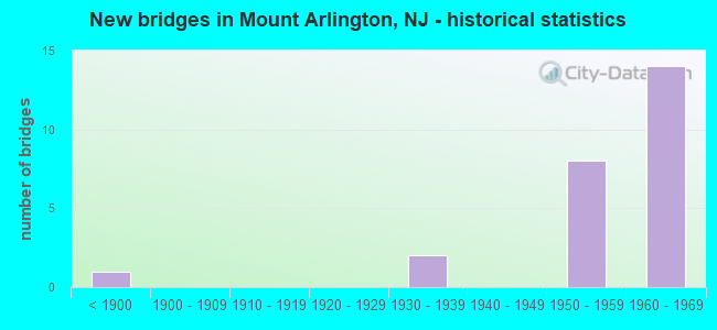
- New bridges - historical statistics
- 1Before 1900
- 21930-1939
- 81950-1959
- 141960-1969

- Reconstructed bridges - Historical Statistics
- 61970-1979
- 31980-1989


- Bridge Condition - Deck
- 23.1%Good
- 23.1%Satisfactory
- 46.2%Fair
- 7.7%Poor

- Bridge Condition - Superstructure
- 50.0%Good
- 35.7%Satisfactory
- 14.3%Fair

- Bridge Condition - Substructure
- 21.4%Good
- 50.0%Satisfactory
- 14.3%Fair
- 14.3%Poor
Find on map >> Show street view
Structure Number: 1400855, Location: S of Altenbrand Ave (Lat: 40.928019, Lng: -74.637411), Route carried "on" structure: County highway 616, Year Built: 1893, Status: Open, Structure Length: 1.10m (3.61ft), Average Daily Traffic: 2,546 (year 2021), Truck Traffic: 3%, Average Future Daily Traffic: 3,107 (year 2041), Features Intersected: WINDERMERE BROOK
Minimum Vertical Clearance: 30+ m (98+ ft), Kilometerpoint: 3.959, Lanes on structure: 2, Owner: County Highway Agency, Approaching Roadway Width: 8.2m (26.9ft), Material/Design: Masonry, Design/Construction: Arch - Deck, Number Of Spans In Main Unit: 1, Length of Maximum Span: 7.6m (24.9ft), Curb or Sidewalk Widths: Left: 0.0m, Right: 1.8m (5.9ft), Curb-To-Curb Width: 8.5m (27.9ft), Out-to-Out Width: 12.1m (39.7ft)
Condition: Superstructure: Good, Substructure: Good, Channel: Satisfactory, Operating Rating: 40.8 metric tons, Method Used To Determine Operating Rating: Field evaluation and documented engineering judgment, Inventory Rating: 24.5 metric tons, Method Used To Determine Inventory Rating: Field evaluation and documented engineering judgment, Structural Evaluation: Equal to present minimum criteria, Deck Geometry: Meets minimum limits, Waterway Adequacy: Superior to present desirable criteria, Approach Roadway Alignment: Equal to present minimum criteria, Designated Inspection Frequency: Every 24 months, Inspection Date: August 2021
Find on map >> Show street view
Structure Number: 1408153, Location: 0.22 Mile South of RT 80 (Lat: 40.890169, Lng: -74.665169), Route carried "on" structure: County highway 631, Year Built: 1934, Status: Open, Structure Length: 2.87m (9.42ft), Average Daily Traffic: 12,807 (year 2020), Truck Traffic: 4%, Average Future Daily Traffic: 15,627 (year 2040), Features Intersected: US 46 WB
Minimum Vertical Clearance: 30+ m (98+ ft), Kilometerpoint: 0.145, Lanes on structure: 1, Lanes under structure: 1, Owner: State Highway Agency, Approaching Roadway Width: 7.3m (24.0ft), Skew: 5 degrees, Material/Design: Steel, Design/Construction: Girder and Floorbeam System, Number Of Spans In Main Unit: 1, Length of Maximum Span: 26.2m (86.0ft), Curb or Sidewalk Widths: Left: 1.9m (6.2ft), Right: 0.0m, Curb-To-Curb Width: 7.3m (24.0ft), Out-to-Out Width: 7.8m (25.6ft)
Condition: Deck: Fair, Superstructure: Satisfactory, Substructure: Satisfactory, Operating Rating: 73.5 metric tons, Method Used To Determine Operating Rating: Load Factor (LF), Inventory Rating: 43.5 metric tons, Method Used To Determine Inventory Rating: Load Factor (LF), Structural Evaluation: Equal to present minimum criteria, Deck Geometry: High priority of replacement, Underclear: Somewhat better than minimum adequacy, Approach Roadway Alignment: Better than present minimum criteria, Designated Inspection Frequency: Every 24 months, Critical Feature Inspection Frequency: Every 24 months, Inspection Date: March 2020, Critical Feature Inspection Date: March 2020, Deck Structure Type: Concrete Cast-file-Place, Wearing Surface/Protective System: Wearing Surface: Monolithic Concrete
Find on map >> Show street view
Structure Number: 1412158, Location: 0.68 MI EAST OF US 46 (Lat: 40.892631, Lng: -74.667089), Route carried "on" structure: Interstate 80, Year Built: 1960, Status: Open, Structure Length: 1.98m (6.50ft), Average Daily Traffic: 48,303 (year 2021), Truck Traffic: 9%, Average Future Daily Traffic: 57,963 (year 2041), Design Load: HS 20, Features Intersected: LANDING RD SB (CR 631)
Minimum Vertical Clearance: 30+ m (98+ ft), Kilometerpoint: 46.381, Lanes on structure: 3, Lanes under structure: 2, Base Highway Network: Yes, Owner: State Highway Agency, Approaching Roadway Width: 15.8m (51.8ft), Skew: 2 degrees, Material/Design: Prestressed concrete, Design/Construction: Stringer/Multi-beam, Number Of Spans In Main Unit: 1, Length of Maximum Span: 18.0m (59.1ft), Curb or Sidewalk Widths: Left: 0.5m (1.6ft), Right: 0.5m (1.6ft), Curb-To-Curb Width: 15.8m (51.8ft), Out-to-Out Width: 17.0m (55.8ft)
Condition: Deck: Good, Superstructure: Good, Substructure: Satisfactory, Operating Rating: 45.4 metric tons, Method Used To Determine Operating Rating: Load Factor (LF), Inventory Rating: 27.2 metric tons, Method Used To Determine Inventory Rating: Load Factor (LF), Structural Evaluation: Equal to present minimum criteria, Deck Geometry: Somewhat better than minimum adequacy, Underclear: Meets minimum limits, Approach Roadway Alignment: Equal to present desirable criteria, Designated Inspection Frequency: Every 24 months, Inspection Date: April 2021, Deck Structure Type: Concrete Cast-file-Place, Wearing Surface/Protective System: Wearing Surface: Bituminous
Find on map >> Show street view
Structure Number: 1412159, Location: 0.68 MI WEST OF US 46 (Lat: 40.892961, Lng: -74.666961), Route carried "on" structure: Interstate 80, Year Built: 1960, Year Reconstructed: 1975, Status: Open, Structure Length: 1.86m (6.10ft), Average Daily Traffic: 48,303 (year 2021), Truck Traffic: 9%, Average Future Daily Traffic: 57,963 (year 2041), Design Load: HS 20, Features Intersected: LANDING RD SB (CR 631)
Minimum Vertical Clearance: 30+ m (98+ ft), Kilometerpoint: 46.381, Lanes on structure: 3, Lanes under structure: 2, Base Highway Network: Yes, Owner: State Highway Agency, Approaching Roadway Width: 15.8m (51.8ft), Skew: 2 degrees, Material/Design: Prestressed concrete, Design/Construction: Stringer/Multi-beam, Number Of Spans In Main Unit: 1, Length of Maximum Span: 16.8m (55.1ft), Curb or Sidewalk Widths: Left: 0.5m (1.6ft), Right: 0.5m (1.6ft), Curb-To-Curb Width: 15.6m (51.2ft), Out-to-Out Width: 17.3m (56.8ft)
Condition: Deck: Fair, Superstructure: Good, Substructure: Satisfactory, Operating Rating: 43.5 metric tons, Method Used To Determine Operating Rating: Load Factor (LF), Inventory Rating: 26.3 metric tons, Method Used To Determine Inventory Rating: Load Factor (LF), Structural Evaluation: Equal to present minimum criteria, Deck Geometry: Somewhat better than minimum adequacy, Underclear: Somewhat better than minimum adequacy, Approach Roadway Alignment: Equal to present desirable criteria, Designated Inspection Frequency: Every 24 months, Inspection Date: April 2021, Deck Structure Type: Concrete Cast-file-Place, Wearing Surface/Protective System: Wearing Surface: Bituminous
Find on map >> Show street view
Structure Number: 141216, Location: AT I-80 EXIT 28 (Lat: 40.894089, Lng: -74.666861), Route carried "on" structure: Ramp Interstate 80, Year Built: 1960, Year Reconstructed: 1984, Status: Open, Structure Length: 1.37m (4.49ft), Average Daily Traffic: 8,175 (year 2021), Truck Traffic: 9%, Average Future Daily Traffic: 9,810 (year 2041), Design Load: HS 20, Features Intersected: LANDING RD SB (CR 631)
Minimum Vertical Clearance: 30+ m (98+ ft), Kilometerpoint: 46.381, Lanes on structure: 1, Lanes under structure: 2, Owner: State Highway Agency, Approaching Roadway Width: 7.0m (23.0ft), Material/Design: Prestressed concrete, Design/Construction: Stringer/Multi-beam, Number Of Spans In Main Unit: 1, Length of Maximum Span: 12.2m (40.0ft), Curb or Sidewalk Widths: Left: 0.5m (1.6ft), Right: 0.5m (1.6ft), Curb-To-Curb Width: 6.9m (22.6ft), Out-to-Out Width: 8.6m (28.2ft)
Condition: Deck: Satisfactory, Superstructure: Satisfactory, Substructure: Satisfactory, Operating Rating: 55.3 metric tons, Method Used To Determine Operating Rating: Load Factor (LF), Inventory Rating: 32.7 metric tons, Method Used To Determine Inventory Rating: Load Factor (LF), Structural Evaluation: Equal to present minimum criteria, Deck Geometry: Equal to present minimum criteria, Underclear: Meets minimum limits, Approach Roadway Alignment: Equal to present minimum criteria, Designated Inspection Frequency: Every 24 months, Inspection Date: April 2021, Deck Structure Type: Concrete Cast-file-Place, Wearing Surface/Protective System: Wearing Surface: Latex Concrete
Find on map >> Show street view
Structure Number: 1412161, Location: 0.77 MI E of US 46 (Lat: 40.891581, Lng: -74.665211), Route carried "on" structure: Ramp Interstate 80, Year Built: 1960, Year Reconstructed: 1985, Status: Open, Structure Length: 1.37m (4.49ft), Average Daily Traffic: 6,048 (year 2021), Truck Traffic: 9%, Average Future Daily Traffic: 7,257 (year 2041), Design Load: HS 20, Features Intersected: LANDING ROAD NB (CR 631)
Minimum Vertical Clearance: 30+ m (98+ ft), Kilometerpoint: 46.526, Lanes on structure: 1, Lanes under structure: 2, Owner: State Highway Agency, Approaching Roadway Width: 7.0m (23.0ft), Material/Design: Prestressed concrete, Design/Construction: Stringer/Multi-beam, Number Of Spans In Main Unit: 1, Length of Maximum Span: 12.2m (40.0ft), Curb-To-Curb Width: 7.3m (24.0ft), Out-to-Out Width: 8.4m (27.6ft)
Condition: Deck: Satisfactory, Superstructure: Fair, Substructure: Good, Operating Rating: 55.3 metric tons, Method Used To Determine Operating Rating: Load Factor (LF), Inventory Rating: 32.7 metric tons, Method Used To Determine Inventory Rating: Load Factor (LF), Structural Evaluation: Somewhat better than minimum adequacy, Deck Geometry: Better than present minimum criteria, Underclear: Meets minimum limits, Approach Roadway Alignment: Better than present minimum criteria, Designated Inspection Frequency: Every 24 months, Inspection Date: April 2021, Deck Structure Type: Concrete Cast-file-Place, Wearing Surface/Protective System: Wearing Surface: Latex Concrete, Deck Protection: Epoxy Coated Reinforcing
Find on map >> Show street view
Structure Number: 1412162, Location: 0.77 MI WEST OF US 46 (Lat: 40.892511, Lng: -74.665331), Route carried "on" structure: Interstate 80, Year Built: 1960, Year Reconstructed: 1975, Status: Open, Structure Length: 1.71m (5.61ft), Average Daily Traffic: 48,303 (year 2021), Truck Traffic: 9%, Average Future Daily Traffic: 57,963 (year 2041), Design Load: HS 20, Features Intersected: LANDING RD NB (CR 631)
Minimum Vertical Clearance: 30+ m (98+ ft), Kilometerpoint: 46.526, Lanes on structure: 3, Lanes under structure: 2, Base Highway Network: Yes, Owner: State Highway Agency, Approaching Roadway Width: 15.5m (50.9ft), Skew: 1 degrees, Material/Design: Prestressed concrete, Design/Construction: Stringer/Multi-beam, Number Of Spans In Main Unit: 1, Length of Maximum Span: 15.5m (50.9ft), Curb or Sidewalk Widths: Left: 0.5m (1.6ft), Right: 0.5m (1.6ft), Curb-To-Curb Width: 15.5m (50.9ft), Out-to-Out Width: 17.2m (56.4ft)
Condition: Deck: Fair, Superstructure: Good, Substructure: Satisfactory, Operating Rating: 51.7 metric tons, Method Used To Determine Operating Rating: Load Factor (LF), Inventory Rating: 30.8 metric tons, Method Used To Determine Inventory Rating: Load Factor (LF), Structural Evaluation: Equal to present minimum criteria, Deck Geometry: Somewhat better than minimum adequacy, Underclear: Somewhat better than minimum adequacy, Approach Roadway Alignment: Equal to present desirable criteria, Designated Inspection Frequency: Every 24 months, Inspection Date: April 2021, Deck Structure Type: Concrete Cast-file-Place, Wearing Surface/Protective System: Wearing Surface: Bituminous
Find on map >> Show street view
Structure Number: 1412163, Location: 1.7 MI WEST OF EXIT 30 (Lat: 40.892861, Lng: -74.665219), Route carried "on" structure: Interstate 80, Year Built: 1959, Year Reconstructed: 1975, Status: Open, Structure Length: 1.77m (5.81ft), Average Daily Traffic: 48,303 (year 2021), Truck Traffic: 9%, Average Future Daily Traffic: 57,963 (year 2041), Design Load: HS 20, Features Intersected: LANDING ROAD NB (CR 631)
Minimum Vertical Clearance: 30+ m (98+ ft), Kilometerpoint: 46.526, Lanes on structure: 3, Lanes under structure: 2, Base Highway Network: Yes, Owner: State Highway Agency, Approaching Roadway Width: 15.5m (50.9ft), Skew: 1 degrees, Material/Design: Prestressed concrete, Design/Construction: Stringer/Multi-beam, Number Of Spans In Main Unit: 1, Length of Maximum Span: 16.2m (53.1ft), Curb or Sidewalk Widths: Left: 0.5m (1.6ft), Right: 0.5m (1.6ft), Curb-To-Curb Width: 15.5m (50.9ft), Out-to-Out Width: 17.2m (56.4ft)
Condition: Deck: Fair, Superstructure: Fair, Substructure: Satisfactory, Operating Rating: 45.4 metric tons, Method Used To Determine Operating Rating: Load Factor (LF), Inventory Rating: 27.2 metric tons, Method Used To Determine Inventory Rating: Load Factor (LF), Structural Evaluation: Somewhat better than minimum adequacy, Deck Geometry: Somewhat better than minimum adequacy, Underclear: Meets minimum limits, Approach Roadway Alignment: Equal to present desirable criteria, Designated Inspection Frequency: Every 24 months, Inspection Date: April 2021, Deck Structure Type: Concrete Cast-file-Place, Wearing Surface/Protective System: Wearing Surface: Bituminous
Find on map >> Show street view
Structure Number: 1412164, Location: 0.2 MI NORTH OF I-80 (Lat: 40.896039, Lng: -74.666569), Route carried "on" structure: County highway 631, Year Built: 1960, Year Reconstructed: 1986, Status: Open, Structure Length: 1.46m (4.79ft), Average Daily Traffic: 11,795 (year 2021), Truck Traffic: 4%, Average Future Daily Traffic: 14,154 (year 2041), Design Load: HS 20, Features Intersected: SHIPPENPORT ROAD, Facility Carried by Structure: LANDING RD SB
Minimum Vertical Clearance: 30+ m (98+ ft), Kilometerpoint: 0.772, Lanes on structure: 2, Lanes under structure: 2, Owner: State Highway Agency, Approaching Roadway Width: 8.5m (27.9ft), Material/Design: Prestressed concrete, Design/Construction: Stringer/Multi-beam, Number Of Spans In Main Unit: 1, Length of Maximum Span: 13.1m (43.0ft), Curb-To-Curb Width: 8.5m (27.9ft), Out-to-Out Width: 9.6m (31.5ft)
Condition: Deck: Good, Superstructure: Good, Substructure: Satisfactory, Operating Rating: 59.0 metric tons, Method Used To Determine Operating Rating: Load Factor (LF), Inventory Rating: 35.4 metric tons, Method Used To Determine Inventory Rating: Load Factor (LF), Structural Evaluation: Equal to present minimum criteria, Deck Geometry: High priority of corrective action, Underclear: Meets minimum limits, Approach Roadway Alignment: Equal to present minimum criteria, Length Of Structure Improvement: 1.46m (4.79ft), Designated Inspection Frequency: Every 24 months, Inspection Date: April 2021, Bridge Improvement Cost: $80,000, Roadway Improvement Cost: $48,000, Total Project Cost: $188,000 ( Estimate for 2021), Deck Structure Type: Concrete Cast-file-Place, Wearing Surface/Protective System: Deck Protection: Epoxy Coated Reinforcing
Find on map >> Show street view
Structure Number: 1412165, Location: 0.1 MI N OF I-80 EXIT 28 (Lat: 40.895961, Lng: -74.666250), Route carried "on" structure: County highway 631, Year Built: 1960, Year Reconstructed: 1985, Status: Open, Structure Length: 1.49m (4.89ft), Average Daily Traffic: 11,794 (year 2021), Truck Traffic: 4%, Average Future Daily Traffic: 14,152 (year 2041), Design Load: HS 20, Features Intersected: SHIPPENPORT ROAD
Minimum Vertical Clearance: 30+ m (98+ ft), Kilometerpoint: 0.772, Lanes on structure: 2, Lanes under structure: 2, Owner: State Highway Agency, Approaching Roadway Width: 8.5m (27.9ft), Skew: 1 degrees, Material/Design: Prestressed concrete, Design/Construction: Stringer/Multi-beam, Number Of Spans In Main Unit: 1, Length of Maximum Span: 13.1m (43.0ft), Curb-To-Curb Width: 8.4m (27.6ft), Out-to-Out Width: 9.5m (31.2ft)
Condition: Deck: Good, Superstructure: Good, Substructure: Good, Operating Rating: 56.2 metric tons, Method Used To Determine Operating Rating: Load Factor (LF), Inventory Rating: 33.6 metric tons, Method Used To Determine Inventory Rating: Load Factor (LF), Structural Evaluation: Better than present minimum criteria, Deck Geometry: High priority of corrective action, Underclear: Meets minimum limits, Approach Roadway Alignment: Equal to present desirable criteria, Length Of Structure Improvement: 1.49m (4.89ft), Designated Inspection Frequency: Every 24 months, Inspection Date: May 2021, Bridge Improvement Cost: $102,000, Roadway Improvement Cost: $30,000, Total Project Cost: $214,000 ( Estimate for 2021), Deck Structure Type: Concrete Cast-file-Place, Wearing Surface/Protective System: Deck Protection: Epoxy Coated Reinforcing
Find on map >> Show street view
Structure Number: 1412166, Location: 0.2 MI E OF I-80 EXIT 28 (Lat: 40.892250, Lng: -74.660300), Route carried "on" structure: Interstate 80, Year Built: 1959, Status: Open, Structure Length: 5.33m (17.49ft), Average Daily Traffic: 45,530 (year 2021), Truck Traffic: 9%, Average Future Daily Traffic: 54,636 (year 2041), Design Load: HS 20+Mod, Features Intersected: NJ Transit-Morristown
Minimum Vertical Clearance: 30+ m (98+ ft), Kilometerpoint: 46.977, Lanes on structure: 3, Base Highway Network: Yes, Owner: State Highway Agency, Approaching Roadway Width: 16.8m (55.1ft), Skew: 6 degrees, Material/Design: Steel, Design/Construction: Stringer/Multi-beam, Number Of Spans In Main Unit: 1, Length of Maximum Span: 33.5m (109.9ft), Curb-To-Curb Width: 16.4m (53.8ft), Out-to-Out Width: 18.0m (59.1ft)
Condition: Deck: Fair, Superstructure: Satisfactory, Substructure: Fair, Operating Rating: 65.3 metric tons, Method Used To Determine Operating Rating: Load Factor (LF), Inventory Rating: 39.0 metric tons, Method Used To Determine Inventory Rating: Load Factor (LF), Structural Evaluation: Somewhat better than minimum adequacy, Deck Geometry: Equal to present minimum criteria, Underclear: Better than present minimum criteria, Approach Roadway Alignment: Equal to present desirable criteria, Designated Inspection Frequency: Every 24 months, Critical Feature Inspection Frequency: Every 24 months, Inspection Date: April 2021, Critical Feature Inspection Date: April 2021, Deck Structure Type: Concrete Cast-file-Place, Wearing Surface/Protective System: Wearing Surface: Bituminous
Find on map >> Show street view
Structure Number: 1412167, Location: AT I-80 EXIT 28 (Lat: 40.892561, Lng: -74.660811), Route carried "on" structure: Interstate 80, Year Built: 1959, Status: Open, Structure Length: 5.00m (16.40ft), Average Daily Traffic: 45,530 (year 2021), Truck Traffic: 9%, Average Future Daily Traffic: 54,636 (year 2041), Design Load: HS 20+Mod, Features Intersected: NJ Transit-Morristown Ln
Minimum Vertical Clearance: 30+ m (98+ ft), Kilometerpoint: 46.977, Lanes on structure: 3, Base Highway Network: Yes, Owner: State Highway Agency, Approaching Roadway Width: 16.2m (53.1ft), Skew: 6 degrees, Material/Design: Steel, Design/Construction: Stringer/Multi-beam, Number Of Spans In Main Unit: 1, Length of Maximum Span: 29.0m (95.1ft), Curb or Sidewalk Widths: Left: 0.0m, Right: 0.5m (1.6ft), Curb-To-Curb Width: 16.3m (53.5ft), Out-to-Out Width: 18.0m (59.1ft)
Condition: Deck: Satisfactory, Superstructure: Good, Substructure: Fair, Operating Rating: 58.1 metric tons, Method Used To Determine Operating Rating: Load Factor (LF), Inventory Rating: 34.5 metric tons, Method Used To Determine Inventory Rating: Load Factor (LF), Structural Evaluation: Somewhat better than minimum adequacy, Deck Geometry: Equal to present minimum criteria, Underclear: Better than present minimum criteria, Approach Roadway Alignment: Equal to present desirable criteria, Designated Inspection Frequency: Every 24 months, Critical Feature Inspection Frequency: Every 24 months, Inspection Date: April 2021, Critical Feature Inspection Date: April 2021, Deck Structure Type: Concrete Cast-file-Place, Wearing Surface/Protective System: Wearing Surface: Bituminous
Find on map >> Show street view
Structure Number: 1412168, Location: 1.90 M.W. OF ROCKAWAY R. (Lat: 40.897361, Lng: -74.634361), Route carried "on" structure: Interstate 80, Year Built: 1959, Year Reconstructed: 1975, Status: Open, Structure Length: 2.29m (7.51ft), Average Daily Traffic: 52,857 (year 2021), Truck Traffic: 9%, Average Future Daily Traffic: 63,428 (year 2041), Design Load: HS 20, Features Intersected: HOWARD BLVD. (CR 615)
Minimum Vertical Clearance: 30+ m (98+ ft), Kilometerpoint: 49.262, Lanes on structure: 4, Lanes under structure: 4, Base Highway Network: Yes, Owner: State Highway Agency, Approaching Roadway Width: 15.8m (51.8ft), Skew: 2 degrees, Material/Design: Prestressed concrete, Design/Construction: Stringer/Multi-beam, Number Of Spans In Main Unit: 1, Length of Maximum Span: 21.0m (68.9ft), Curb or Sidewalk Widths: Left: 0.5m (1.6ft), Right: 0.5m (1.6ft), Curb-To-Curb Width: 15.8m (51.8ft), Out-to-Out Width: 17.5m (57.4ft)
Condition: Deck: Fair, Superstructure: Satisfactory, Substructure: Poor, Operating Rating: 33.6 metric tons, Method Used To Determine Operating Rating: Load Factor (LF), Inventory Rating: 20.0 metric tons, Method Used To Determine Inventory Rating: Load Factor (LF), Structural Evaluation: Meets minimum limits, Deck Geometry: High priority of replacement, Underclear: Meets minimum limits, Approach Roadway Alignment: Equal to present desirable criteria, Length Of Structure Improvement: 2.29m (7.51ft), Designated Inspection Frequency: Every 24 months, Inspection Date: April 2021, Bridge Improvement Cost: $125,000, Roadway Improvement Cost: $22,000, Total Project Cost: $337,000 ( Estimate for 2021), Deck Structure Type: Concrete Cast-file-Place, Wearing Surface/Protective System: Wearing Surface: Bituminous
Find on map >> Show street view
Structure Number: 1412169, Location: 1.95 M.W. OF ROCKAWAY R. (Lat: 40.897881, Lng: -74.634039), Route carried "on" structure: Interstate 80, Year Built: 1959, Year Reconstructed: 1975, Status: Open, Structure Length: 2.29m (7.51ft), Average Daily Traffic: 52,857 (year 2021), Truck Traffic: 9%, Average Future Daily Traffic: 63,428 (year 2041), Design Load: HS 20, Features Intersected: HOWARD BOULEVARD (615)
Minimum Vertical Clearance: 30+ m (98+ ft), Kilometerpoint: 49.262, Lanes on structure: 3, Lanes under structure: 4, Base Highway Network: Yes, Owner: State Highway Agency, Approaching Roadway Width: 15.8m (51.8ft), Skew: 2 degrees, Material/Design: Prestressed concrete, Design/Construction: Stringer/Multi-beam, Number Of Spans In Main Unit: 1, Length of Maximum Span: 21.0m (68.9ft), Curb or Sidewalk Widths: Left: 0.5m (1.6ft), Right: 0.5m (1.6ft), Curb-To-Curb Width: 15.8m (51.8ft), Out-to-Out Width: 17.5m (57.4ft)
Condition: Deck: Poor, Superstructure: Satisfactory, Substructure: Poor, Operating Rating: 33.6 metric tons, Method Used To Determine Operating Rating: Load Factor (LF), Inventory Rating: 20.0 metric tons, Method Used To Determine Inventory Rating: Load Factor (LF), Structural Evaluation: Meets minimum limits, Deck Geometry: Somewhat better than minimum adequacy, Underclear: Meets minimum limits, Approach Roadway Alignment: Equal to present desirable criteria, Length Of Structure Improvement: 3.08m (10.10ft), Designated Inspection Frequency: Every 24 months, Inspection Date: April 2021, Bridge Improvement Cost: $2,443,000, Roadway Improvement Cost: $244,000, Total Project Cost: $3,898,000 ( Estimate for 2021), Deck Structure Type: Concrete Cast-file-Place, Wearing Surface/Protective System: Wearing Surface: Bituminous
Find on map >> Show street view
Structure Number: 1408153, Location: 0.22 Mile South of RT 80 (Lat: 40.890169, Lng: -74.665169), Route carried "under" structure: US 46, Year Built: 1934, Structure Length: 0. m, Average Daily Traffic: 22,929 (year 2020), Truck Traffic: 4%, Features Intersected: US 46 WB, Facility Carried by Structure: LANDING RD SB C631
Minimum Vertical Clearance: 4.37m (14.34ft), Kilometerpoint: 51.901, Lanes on structure: 1, Lanes under structure: 1, Material/Design: Steel, Design/Construction: Girder and Floorbeam System, Length of Maximum Span: 26.2m (86.0ft)
Find on map >> Show street view
Structure Number: 1412158, Location: 0.68 MI EAST OF US 46 (Lat: 40.892631, Lng: -74.667089), Route carried "under" structure: County highway 631, Year Built: 1960, Structure Length: 0. m, Average Daily Traffic: 11,795 (year 2021), Truck Traffic: 4%, Features Intersected: LANDING RD SB (CR 631), Facility Carried by Structure: I-80 EB
Minimum Vertical Clearance: 4.52m (14.83ft), Kilometerpoint: 0.386, Lanes on structure: 3, Lanes under structure: 2, Material/Design: Prestressed concrete, Design/Construction: Stringer/Multi-beam, Length of Maximum Span: 18.0m (59.1ft)
Find on map >> Show street view
Structure Number: 1412159, Location: 0.68 MI WEST OF US 46 (Lat: 40.892961, Lng: -74.666961), Route carried "under" structure: County highway 631, Year Built: 1960, Structure Length: 0. m, Average Daily Traffic: 11,795 (year 2021), Truck Traffic: 4%, Features Intersected: LANDING RD SB (CR 631), Facility Carried by Structure: I-80 WB
Minimum Vertical Clearance: 4.50m (14.76ft), Kilometerpoint: 0.386, Lanes on structure: 3, Lanes under structure: 2, Material/Design: Prestressed concrete, Design/Construction: Stringer/Multi-beam, Length of Maximum Span: 16.8m (55.1ft)
Find on map >> Show street view
Structure Number: 141216, Location: AT I-80 EXIT 28 (Lat: 40.894089, Lng: -74.666861), Route carried "under" structure: County highway 631, Year Built: 1960, Structure Length: 0. m, Average Daily Traffic: 11,795 (year 2021), Truck Traffic: 4%, Features Intersected: LANDING RD SB (CR 631), Facility Carried by Structure: I-80 RAMP F
Minimum Vertical Clearance: 4.40m (14.44ft), Kilometerpoint: 0.547, Lanes on structure: 1, Lanes under structure: 2, Material/Design: Prestressed concrete, Design/Construction: Stringer/Multi-beam, Length of Maximum Span: 12.2m (40.0ft)
Find on map >> Show street view
Structure Number: 1412161, Location: 0.77 MI E of US 46 (Lat: 40.891581, Lng: -74.665211), Route carried "under" structure: County highway 631, Year Built: 1960, Structure Length: 0. m, Average Daily Traffic: 11,795 (year 2021), Truck Traffic: 4%, Features Intersected: LANDING ROAD NB (CR 631), Facility Carried by Structure: I-80 RAMP "D"
Minimum Vertical Clearance: 4.55m (14.93ft), Kilometerpoint: 0.274, Lanes on structure: 1, Lanes under structure: 2, Material/Design: Prestressed concrete, Design/Construction: Stringer/Multi-beam, Length of Maximum Span: 12.2m (40.0ft)
Find on map >> Show street view
Structure Number: 1412162, Location: 0.77 MI WEST OF US 46 (Lat: 40.892511, Lng: -74.665331), Route carried "under" structure: County highway 631, Year Built: 1960, Structure Length: 0. m, Average Daily Traffic: 11,795 (year 2021), Truck Traffic: 4%, Features Intersected: LANDING RD NB (CR 631), Facility Carried by Structure: I-80 EB
Minimum Vertical Clearance: 5.36m (17.59ft), Kilometerpoint: 0.386, Lanes on structure: 3, Lanes under structure: 2, Material/Design: Prestressed concrete, Design/Construction: Stringer/Multi-beam, Length of Maximum Span: 15.5m (50.9ft)
Find on map >> Show street view
Structure Number: 1412163, Location: 1.7 MI WEST OF EXIT 30 (Lat: 40.892861, Lng: -74.665219), Route carried "under" structure: County highway 630, Year Built: 1959, Structure Length: 0. m, Average Daily Traffic: 11,795 (year 2021), Truck Traffic: 4%, Features Intersected: LANDING ROAD NB (CR 631), Facility Carried by Structure: I-80 WB
Minimum Vertical Clearance: 4.50m (14.76ft), Kilometerpoint: 0.386, Lanes on structure: 3, Lanes under structure: 2, Material/Design: Prestressed concrete, Design/Construction: Stringer/Multi-beam, Length of Maximum Span: 16.2m (53.1ft)
Find on map >> Show street view
Structure Number: 1412164, Location: 0.2 MI NORTH OF I-80 (Lat: 40.896039, Lng: -74.666569), Route carried "under" structure: Ramp City street , Year Built: 1960, Structure Length: 0. m, Average Daily Traffic: 3,897 (year 2021), Truck Traffic: 1%, Features Intersected: SHIPPENPORT ROAD, Facility Carried by Structure: LANDING RD SB
Minimum Vertical Clearance: 4.60m (15.09ft), Kilometerpoint: 0.000, Lanes on structure: 2, Lanes under structure: 2, Material/Design: Prestressed concrete, Design/Construction: Stringer/Multi-beam, Length of Maximum Span: 13.1m (43.0ft)
Find on map >> Show street view
Structure Number: 1412165, Location: 0.1 MI N OF I-80 EXIT 28 (Lat: 40.895961, Lng: -74.666250), Route carried "under" structure: Ramp City street , Year Built: 1960, Structure Length: 0. m, Average Daily Traffic: 3,897 (year 2021), Truck Traffic: 1%, Features Intersected: SHIPPENPORT ROAD, Facility Carried by Structure: LANDING RD NB C631
Minimum Vertical Clearance: 4.57m (14.99ft), Kilometerpoint: 0.000, Lanes on structure: 2, Lanes under structure: 2, Material/Design: Prestressed concrete, Design/Construction: Stringer/Multi-beam, Length of Maximum Span: 13.1m (43.0ft)
Find on map >> Show street view
Structure Number: 1412168, Location: 1.90 M.W. OF ROCKAWAY R. (Lat: 40.897361, Lng: -74.634361), Route carried "under" structure: County highway 615, Year Built: 1959, Structure Length: 0. m, Average Daily Traffic: 17,397 (year 2021), Truck Traffic: 4%, Features Intersected: HOWARD BLVD. (CR 615), Facility Carried by Structure: I-80 EASTBOUND
Minimum Vertical Clearance: 4.65m (15.26ft), Kilometerpoint: 2.494, Lanes on structure: 4, Lanes under structure: 4, Material/Design: Prestressed concrete, Design/Construction: Stringer/Multi-beam, Length of Maximum Span: 21.0m (68.9ft)
Find on map >> Show street view
Structure Number: 1412169, Location: 1.95 M.W. OF ROCKAWAY R. (Lat: 40.897881, Lng: -74.634039), Route carried "under" structure: County highway 615, Year Built: 1959, Structure Length: 0. m, Average Daily Traffic: 17,397 (year 2021), Truck Traffic: 4%, Features Intersected: HOWARD BOULEVARD (615), Facility Carried by Structure: I-80 WB
Minimum Vertical Clearance: 4.44m (14.57ft), Kilometerpoint: 2.494, Lanes on structure: 3, Lanes under structure: 4, Material/Design: Prestressed concrete, Design/Construction: Stringer/Multi-beam, Length of Maximum Span: 21.0m (68.9ft)