Bridge Statistics for Moscow, Pennsylvania (PA)
Condition, Traffic, Stress, Structural Evaluation, Project Costs
- National Bridge Inventory (NBI) Statistics
- 26Number of bridges
- 200ft / 60.8mTotal length
- $9,255,000Total costs
- 142,180Total average daily traffic
- 22,578Total average daily truck traffic
- National Bridge Inventory (NBI) Registered Bridges for Moscow
- No street view available for this location
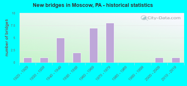
- New bridges - historical statistics
- 11920-1929
- 11930-1939
- 51940-1949
- 21950-1959
- 71960-1969
- 81970-1979
- 12000-2009
- 12010-2019

- Reconstructed bridges - Historical Statistics
- 21970-1979
- 01980-1989
- 01990-1999
- 62000-2009
- 12010-2019


- Bridge Condition - Deck
- 7.1%Very good
- 50.0%Good
- 21.4%Satisfactory
- 7.1%Fair
- 14.3%Poor

- Bridge Condition - Superstructure
- 6.7%Very good
- 13.3%Good
- 46.7%Satisfactory
- 13.3%Fair
- 20.0%Poor

- Bridge Condition - Substructure
- 33.3%Good
- 26.7%Satisfactory
- 13.3%Fair
- 26.7%Poor

- Bridge Condition - Channel
- 16.7%Good
- 33.3%Satisfactory
- 25.0%Fair
- 25.0%Poor

- Bridge Condition - Culverts
- 66.7%Good
- 33.3%Fair
Find on map >> Show street view
Structure Number: 20557, Location: COVINGTON TWP OVER I-380 (Lat: 41.313936, Lng: -75.546981), Route carried "on" structure: State highway 307, Year Built: 1969, Year Reconstructed: 1983, Status: Open, Structure Length: 11.80m (38.71ft), Average Daily Traffic: 6,298 (year 2020), Truck Traffic: 8%, Average Future Daily Traffic: 9,589 (year 2032), Design Load: HS 20+Mod, Features Intersected: SR 0380 I-380 NB & SB
Minimum Vertical Clearance: 30+ m (98+ ft), Kilometerpoint: 4.009, Lanes on structure: 2, Lanes under structure: 4, Base Highway Network: Yes, Owner: State Highway Agency, Approaching Roadway Width: 18.9m (62.0ft), Skew: 25 degrees, Material/Design: Prestressed concrete, Design/Construction: Box Beam or Girders - Multiple, Number Of Spans In Main Unit: 5, Length of Maximum Span: 28.3m (92.8ft), Curb or Sidewalk Widths: Left: 0.2m (0.7ft), Right: 0.2m (0.7ft), Curb-To-Curb Width: 18.9m (62.0ft), Out-to-Out Width: 20.1m (65.9ft)
Condition: Deck: Satisfactory, Superstructure: Satisfactory, Substructure: Satisfactory, Operating Rating: 96.2 metric tons, Method Used To Determine Operating Rating: Load Factor (LF), Inventory Rating: 29.0 metric tons, Method Used To Determine Inventory Rating: Load Factor (LF), Structural Evaluation: Equal to present minimum criteria, Deck Geometry: Superior to present desirable criteria, Underclear: Equal to present minimum criteria, Approach Roadway Alignment: Equal to present desirable criteria, Length Of Structure Improvement: 11.90m (39.04ft), Designated Inspection Frequency: Every 24 months, Inspection Date: May 2020, Bridge Improvement Cost: $83,000, Roadway Improvement Cost: $243,000, Total Project Cost: $1,116,000, Deck Structure Type: Concrete Cast-file-Place, Wearing Surface/Protective System: Wearing Surface: Latex Concrete
Find on map >> Show street view
Structure Number: 20588, Location: ROARING BRK TP OV SR 2010 (Lat: 41.360414, Lng: -75.571625), Route carried "on" structure: Interstate 380, Year Built: 1975, Year Reconstructed: 2009, Status: Open, Structure Length: 4.94m (16.21ft), Average Daily Traffic: 14,060 (year 2022), Truck Traffic: 23%, Average Future Daily Traffic: 16,435 (year 2032), Design Load: HS 20, Features Intersected: SR 2010
Minimum Vertical Clearance: 30+ m (98+ ft), Kilometerpoint: 15.414, Lanes on structure: 2, Lanes under structure: 2, Base Highway Network: Yes, Owner: State Highway Agency, Approaching Roadway Width: 11.9m (39.0ft), Skew: 10 degrees, Material/Design: Prestressed concrete, Design/Construction: Box Beam or Girders - Single/Spread, Number Of Spans In Main Unit: 3, Length of Maximum Span: 17.7m (58.1ft), Curb or Sidewalk Widths: Left: 0.2m (0.7ft), Right: 0.2m (0.7ft), Curb-To-Curb Width: 12.2m (40.0ft), Out-to-Out Width: 13.4m (44.0ft)
Condition: Deck: Good, Superstructure: Satisfactory, Substructure: Satisfactory, Operating Rating: 65.3 metric tons, Method Used To Determine Operating Rating: Load Factor (LF), Inventory Rating: 23.6 metric tons, Method Used To Determine Inventory Rating: Load Factor (LF), Structural Evaluation: Somewhat better than minimum adequacy, Deck Geometry: Better than present minimum criteria, Underclear: Superior to present desirable criteria, Approach Roadway Alignment: Equal to present desirable criteria, Length Of Structure Improvement: 4.90m (16.08ft), Designated Inspection Frequency: Every 24 months, Inspection Date: September 2021, Bridge Improvement Cost: $42,000, Roadway Improvement Cost: $123,000, Total Project Cost: $566,000, Deck Structure Type: Concrete Cast-file-Place, Wearing Surface/Protective System: Wearing Surface: Latex Concrete, Deck Protection: Galvanized Reinforcing
Find on map >> Show street view
Structure Number: 20589, Location: ROARING BK TWP OV SR 2010 (Lat: 41.360486, Lng: -75.571233), Route carried "on" structure: Interstate 380, Year Built: 1975, Year Reconstructed: 2009, Status: Open, Structure Length: 4.54m (14.90ft), Average Daily Traffic: 14,230 (year 2022), Truck Traffic: 23%, Average Future Daily Traffic: 16,567 (year 2032), Design Load: HS 20, Features Intersected: SR 2010
Minimum Vertical Clearance: 30+ m (98+ ft), Kilometerpoint: 15.220, Lanes on structure: 2, Lanes under structure: 2, Base Highway Network: Yes, Owner: State Highway Agency, Approaching Roadway Width: 11.9m (39.0ft), Skew: 10 degrees, Material/Design: Prestressed concrete, Design/Construction: Box Beam or Girders - Single/Spread, Number Of Spans In Main Unit: 3, Length of Maximum Span: 16.8m (55.1ft), Curb or Sidewalk Widths: Left: 0.2m (0.7ft), Right: 0.2m (0.7ft), Curb-To-Curb Width: 12.2m (40.0ft), Out-to-Out Width: 13.4m (44.0ft)
Condition: Deck: Good, Superstructure: Satisfactory, Substructure: Good, Operating Rating: 75.3 metric tons, Method Used To Determine Operating Rating: Load Factor (LF), Inventory Rating: 35.4 metric tons, Method Used To Determine Inventory Rating: Load Factor (LF), Structural Evaluation: Equal to present minimum criteria, Deck Geometry: Better than present minimum criteria, Underclear: Equal to present desirable criteria, Approach Roadway Alignment: Equal to present desirable criteria, Length Of Structure Improvement: 4.50m (14.76ft), Designated Inspection Frequency: Every 24 months, Inspection Date: September 2021, Bridge Improvement Cost: $42,000, Roadway Improvement Cost: $123,000, Total Project Cost: $564,000, Deck Structure Type: Concrete Cast-file-Place, Wearing Surface/Protective System: Wearing Surface: Latex Concrete, Deck Protection: Galvanized Reinforcing
Find on map >> Show street view
Structure Number: 20593, Location: MOSCOW BORO OVER TR 690 (Lat: 41.333858, Lng: -75.555861), Route carried "on" structure: Interstate 380, Year Built: 1975, Year Reconstructed: 2009, Status: Open, Structure Length: 3.44m (11.29ft), Average Daily Traffic: 11,078 (year 2021), Truck Traffic: 21%, Average Future Daily Traffic: 17,021 (year 2032), Design Load: HS 20, Features Intersected: SR 0690 TR 690
Minimum Vertical Clearance: 30+ m (98+ ft), Kilometerpoint: 12.199, Lanes on structure: 2, Lanes under structure: 2, Base Highway Network: Yes, Owner: State Highway Agency, Approaching Roadway Width: 11.0m (36.1ft), Skew: 10 degrees, Material/Design: Prestressed concrete, Design/Construction: Box Beam or Girders - Single/Spread, Number Of Spans In Main Unit: 3, Length of Maximum Span: 16.5m (54.1ft), Curb or Sidewalk Widths: Left: 0.2m (0.7ft), Right: 0.2m (0.7ft), Curb-To-Curb Width: 11.9m (39.0ft), Out-to-Out Width: 13.2m (43.3ft)
Condition: Deck: Good, Superstructure: Good, Substructure: Good, Operating Rating: 48.1 metric tons, Method Used To Determine Operating Rating: Load Factor (LF), Inventory Rating: 28.1 metric tons, Method Used To Determine Inventory Rating: Load Factor (LF), Structural Evaluation: Better than present minimum criteria, Deck Geometry: Equal to present minimum criteria, Underclear: Better than present minimum criteria, Approach Roadway Alignment: Equal to present desirable criteria, Length Of Structure Improvement: 3.40m (11.15ft), Designated Inspection Frequency: Every 24 months, Inspection Date: September 2021, Bridge Improvement Cost: $43,000, Roadway Improvement Cost: $128,000, Total Project Cost: $585,000, Deck Structure Type: Concrete Cast-file-Place, Wearing Surface/Protective System: Wearing Surface: Latex Concrete, Deck Protection: Epoxy Coated Reinforcing
Find on map >> Show street view
Structure Number: 20594, Location: MOSCOW BORO OVER TR 690 (Lat: 41.333864, Lng: -75.555608), Route carried "on" structure: Interstate 380, Year Built: 1975, Year Reconstructed: 2009, Status: Open, Structure Length: 3.26m (10.70ft), Average Daily Traffic: 11,089 (year 2021), Truck Traffic: 20%, Average Future Daily Traffic: 16,519 (year 2032), Design Load: HS 20, Features Intersected: SR 0690 TR 690
Minimum Vertical Clearance: 30+ m (98+ ft), Kilometerpoint: 11.998, Lanes on structure: 2, Lanes under structure: 2, Base Highway Network: Yes, Owner: State Highway Agency, Approaching Roadway Width: 11.9m (39.0ft), Skew: 10 degrees, Material/Design: Prestressed concrete, Design/Construction: Box Beam or Girders - Single/Spread, Number Of Spans In Main Unit: 3, Length of Maximum Span: 16.5m (54.1ft), Curb or Sidewalk Widths: Left: 0.2m (0.7ft), Right: 0.2m (0.7ft), Curb-To-Curb Width: 11.9m (39.0ft), Out-to-Out Width: 13.2m (43.3ft)
Condition: Deck: Good, Superstructure: Good, Substructure: Good, Operating Rating: 70.8 metric tons, Method Used To Determine Operating Rating: Load Factor (LF), Inventory Rating: 30.8 metric tons, Method Used To Determine Inventory Rating: Load Factor (LF), Structural Evaluation: Better than present minimum criteria, Deck Geometry: Equal to present minimum criteria, Underclear: Equal to present minimum criteria, Approach Roadway Alignment: Equal to present desirable criteria, Length Of Structure Improvement: 3.30m (10.83ft), Designated Inspection Frequency: Every 24 months, Inspection Date: September 2021, Bridge Improvement Cost: $41,000, Roadway Improvement Cost: $121,000, Total Project Cost: $555,000, Deck Structure Type: Concrete Cast-file-Place, Wearing Surface/Protective System: Wearing Surface: Latex Concrete, Deck Protection: Epoxy Coated Reinforcing
Find on map >> Show street view
Structure Number: 20607, Location: MOSCOW BORO 400' S TR 690 (Lat: 41.335478, Lng: -75.517633), Route carried "on" structure: State highway 435, Year Built: 1940, Status: Open, Structure Length: 0.70m (2.30ft), Average Daily Traffic: 6,083 (year 2020), Truck Traffic: 3%, Average Future Daily Traffic: 8,396 (year 2032), Design Load: HS 20, Features Intersected: VAN BRUNT CREEK
Minimum Vertical Clearance: 30+ m (98+ ft), Kilometerpoint: 10.533, Lanes on structure: 2, Owner: State Highway Agency, Approaching Roadway Width: 11.0m (36.1ft), Skew: 4 degrees, Material/Design: Concrete, Design/Construction: Arch - Deck, Number Of Spans In Main Unit: 1, Length of Maximum Span: 7.0m (23.0ft), Curb or Sidewalk Widths: Left: 1.2m (3.9ft), Right: 0.0m, Curb-To-Curb Width: 11.0m (36.1ft), Out-to-Out Width: 12.5m (41.0ft)
Condition: Superstructure: Poor, Substructure: Fair, Channel: Fair, Operating Rating: 49.0 metric tons, Method Used To Determine Operating Rating: Field evaluation and documented engineering judgment, Inventory Rating: 29.0 metric tons, Method Used To Determine Inventory Rating: Field evaluation and documented engineering judgment, Structural Evaluation: Meets minimum limits, Deck Geometry: Meets minimum limits, Waterway Adequacy: Superior to present desirable criteria, Approach Roadway Alignment: Equal to present desirable criteria, Length Of Structure Improvement: 0.70m (2.30ft), Designated Inspection Frequency: Every 24 months, Inspection Date: June 2020, Bridge Improvement Cost: $23,000, Roadway Improvement Cost: $100,000, Total Project Cost: $307,000
Find on map >> Show street view
Structure Number: 2061, Location: ELMHURST TWP .3M N SR2010 (Lat: 41.372797, Lng: -75.543597), Route carried "on" structure: State highway 435, Year Built: 1948, Status: Open, Structure Length: 9.97m (32.71ft), Average Daily Traffic: 6,177 (year 2020), Truck Traffic: 5%, Average Future Daily Traffic: 7,693 (year 2032), Design Load: HS 20, Features Intersected: LACKA CO RR AUTHORITY
Minimum Vertical Clearance: 30+ m (98+ ft), Kilometerpoint: 16.142, Lanes on structure: 2, Owner: Railroad, Maintenance Responsibility: State Highway Agency, Approaching Roadway Width: 8.2m (26.9ft), Skew: 4 degrees, Material/Design: Steel, Design/Construction: Girder and Floorbeam System, Number Of Spans In Main Unit: 1, Number Of Approach Spans: 5, Length of Maximum Span: 28.7m (94.2ft), Curb or Sidewalk Widths: Left: 1.5m (4.9ft), Right: 0.2m (0.7ft), Curb-To-Curb Width: 7.9m (25.9ft), Out-to-Out Width: 10.3m (33.8ft)
Condition: Deck: Fair, Superstructure: Fair, Substructure: Poor, Channel: Fair, Operating Rating: 54.4 metric tons, Method Used To Determine Operating Rating: Load Factor (LF), Inventory Rating: 23.6 metric tons, Method Used To Determine Inventory Rating: Load Factor (LF), Structural Evaluation: Meets minimum limits, Deck Geometry: High priority of corrective action, Underclear: High priority of replacement, Waterway Adequacy: Superior to present desirable criteria, Approach Roadway Alignment: Better than present minimum criteria, Length Of Structure Improvement: 12.20m (40.03ft), Designated Inspection Frequency: Every 24 months, Critical Feature Inspection Frequency: Every 24 months, Inspection Date: June 2020, Critical Feature Inspection Date: June 2021, Bridge Improvement Cost: $250,000, Roadway Improvement Cost: $737,000, Total Project Cost: $3,378,000, Deck Structure Type: Concrete Cast-file-Place, Wearing Surface/Protective System: Wearing Surface: Bituminous
Find on map >> Show street view
Structure Number: 20611, Location: ELMHURST TWP .3M S TR 590 (Lat: 41.376192, Lng: -75.543894), Route carried "on" structure: State highway 435, Year Built: 1948, Status: Open, Structure Length: 2.35m (7.71ft), Average Daily Traffic: 6,177 (year 2020), Truck Traffic: 5%, Average Future Daily Traffic: 7,693 (year 2032), Design Load: HS 20, Features Intersected: ROARING BROOK
Minimum Vertical Clearance: 30+ m (98+ ft), Kilometerpoint: 16.142, Lanes on structure: 2, Owner: State Highway Agency, Approaching Roadway Width: 8.8m (28.9ft), Skew: 4 degrees, Material/Design: Concrete, Design/Construction: Culvert, Number Of Spans In Main Unit: 1, Length of Maximum Span: 23.5m (77.1ft)
Condition: Channel: Satisfactory, Culverts: Fair, Operating Rating: 49.0 metric tons, Method Used To Determine Operating Rating: Field evaluation and documented engineering judgment, Inventory Rating: 32.7 metric tons, Method Used To Determine Inventory Rating: Field evaluation and documented engineering judgment, Structural Evaluation: Somewhat better than minimum adequacy, Waterway Adequacy: Superior to present desirable criteria, Approach Roadway Alignment: Equal to present desirable criteria, Length Of Structure Improvement: 2.30m (7.55ft), Designated Inspection Frequency: Every 24 months, Inspection Date: June 2020, Bridge Improvement Cost: $35,000, Roadway Improvement Cost: $103,000, Total Project Cost: $473,000
Find on map >> Show street view
Structure Number: 20641, Location: COVINGTON TWP OVER I-380 (Lat: 41.300883, Lng: -75.540900), Route carried "on" structure: State highway 502, Year Built: 1969, Year Reconstructed: 2009, Status: Open, Structure Length: 8.38m (27.49ft), Average Daily Traffic: 2,770 (year 2021), Truck Traffic: 7%, Average Future Daily Traffic: 4,437 (year 2032), Design Load: HS 20, Features Intersected: SR 0380 I-380 NB & SB
Minimum Vertical Clearance: 30+ m (98+ ft), Kilometerpoint: 16.765, Lanes on structure: 2, Lanes under structure: 4, Owner: State Highway Agency, Approaching Roadway Width: 8.2m (26.9ft), Material/Design: Prestressed concrete, Design/Construction: Stringer/Multi-beam, Number Of Spans In Main Unit: 5, Length of Maximum Span: 20.1m (65.9ft), Curb or Sidewalk Widths: Left: 0.2m (0.7ft), Right: 0.2m (0.7ft), Curb-To-Curb Width: 10.2m (33.5ft), Out-to-Out Width: 11.4m (37.4ft)
Condition: Deck: Good, Superstructure: Satisfactory, Substructure: Satisfactory, Operating Rating: 59.9 metric tons, Method Used To Determine Operating Rating: Load Factor (LF), Inventory Rating: 24.5 metric tons, Method Used To Determine Inventory Rating: Load Factor (LF), Structural Evaluation: Equal to present minimum criteria, Deck Geometry: Meets minimum limits, Underclear: Meets minimum limits, Approach Roadway Alignment: Better than present minimum criteria, Length Of Structure Improvement: 8.40m (27.56ft), Designated Inspection Frequency: Every 24 months, Inspection Date: June 2020, Bridge Improvement Cost: $59,000, Roadway Improvement Cost: $174,000, Total Project Cost: $797,000, Deck Structure Type: Concrete Cast-file-Place, Wearing Surface/Protective System: Wearing Surface: Monolithic Concrete, Deck Protection: Epoxy Coated Reinforcing
Find on map >> Show street view
Structure Number: 20659, Location: MOSCOW BORO 1.2M W TR 435 (Lat: 41.338403, Lng: -75.541122), Route carried "on" structure: State highway 690, Year Built: 1940, Status: Posted for load, Structure Length: 0.64m (2.10ft), Average Daily Traffic: 2,754 (year 2020), Truck Traffic: 4%, Average Future Daily Traffic: 5,452 (year 2032), Design Load: H 20, Features Intersected: VAN BRUNT CREEK
Minimum Vertical Clearance: 30+ m (98+ ft), Kilometerpoint: 7.490, Lanes on structure: 2, Owner: State Highway Agency, Approaching Roadway Width: 7.6m (24.9ft), Skew: 1 degrees, Material/Design: Steel, Design/Construction: Stringer/Multi-beam, Number Of Spans In Main Unit: 1, Length of Maximum Span: 5.8m (19.0ft), Curb or Sidewalk Widths: Left: 0.1m (0.3ft), Right: 0.1m (0.3ft), Curb-To-Curb Width: 6.8m (22.3ft), Out-to-Out Width: 7.4m (24.3ft)
Condition: Deck: Poor, Superstructure: Poor, Substructure: Fair, Channel: Fair, Operating Rating: 36.3 metric tons, Method Used To Determine Operating Rating: Load Factor (LF), Inventory Rating: 21.8 metric tons, Method Used To Determine Inventory Rating: Load Factor (LF), Structural Evaluation: Meets minimum limits, Deck Geometry: High priority of replacement, Waterway Adequacy: Equal to present minimum criteria, Approach Roadway Alignment: Better than present minimum criteria, Bridge Posting: Required (Relationship of Operating Rating to Maximum Legal Load: 20.0 - 29.9% below), Length Of Structure Improvement: 0.70m (2.30ft), Designated Inspection Frequency: Every 24 months, Other Special Inspection Frequency: Every 6 months, Inspection Date: May 2021, Other Special Inspection Date: May 2021, Bridge Improvement Cost: $19,000, Roadway Improvement Cost: $100,000, Total Project Cost: $254,000, Deck Structure Type: Concrete Cast-file-Place, Wearing Surface/Protective System: Wearing Surface: Bituminous
Find on map >> Show street view
Structure Number: 20662, Location: MOSCOW BORO .2M E SR 2005 (Lat: 41.337706, Lng: -75.513958), Route carried "on" structure: State highway 690, Year Built: 1961, Status: Open, Structure Length: 2.01m (6.59ft), Average Daily Traffic: 2,405 (year 2021), Truck Traffic: 5%, Average Future Daily Traffic: 3,396 (year 2032), Design Load: HS 20, Features Intersected: ROARING BROOK
Minimum Vertical Clearance: 30+ m (98+ ft), Kilometerpoint: 9.799, Lanes on structure: 2, Owner: State Highway Agency, Approaching Roadway Width: 7.6m (24.9ft), Material/Design: Prestressed concrete, Design/Construction: Box Beam or Girders - Multiple, Number Of Spans In Main Unit: 1, Length of Maximum Span: 19.5m (64.0ft), Curb or Sidewalk Widths: Left: 1.5m (4.9ft), Right: 0.5m (1.6ft), Curb-To-Curb Width: 9.1m (29.9ft), Out-to-Out Width: 11.9m (39.0ft)
Condition: Deck: Poor, Superstructure: Poor, Substructure: Good, Channel: Satisfactory, Operating Rating: 42.6 metric tons, Method Used To Determine Operating Rating: Load Factor (LF), Inventory Rating: 6.4 metric tons, Method Used To Determine Inventory Rating: Load Factor (LF), Structural Evaluation: High priority of corrective action, Deck Geometry: Meets minimum limits, Waterway Adequacy: Equal to present desirable criteria, Approach Roadway Alignment: Equal to present desirable criteria, Length Of Structure Improvement: 2.70m (8.86ft), Designated Inspection Frequency: Every 24 months, Inspection Date: July 2020, Bridge Improvement Cost: $17,000, Roadway Improvement Cost: $100,000, Total Project Cost: $230,000, Deck Structure Type: Other, Wearing Surface/Protective System: Wearing Surface: Bituminous
Find on map >> Show street view
Structure Number: 20663, Location: MOSCOW BORO .2 M E SR2005 (Lat: 41.338556, Lng: -75.512358), Route carried "on" structure: State highway 690, Year Built: 1933, Status: Open, Structure Length: 0.79m (2.59ft), Average Daily Traffic: 2,405 (year 2021), Truck Traffic: 5%, Average Future Daily Traffic: 3,396 (year 2032), Design Load: H 20, Features Intersected: BEAR BROOK
Minimum Vertical Clearance: 30+ m (98+ ft), Kilometerpoint: 10.548, Lanes on structure: 2, Owner: State Highway Agency, Approaching Roadway Width: 7.3m (24.0ft), Skew: 4 degrees, Material/Design: Concrete, Design/Construction: Slab, Number Of Spans In Main Unit: 1, Length of Maximum Span: 7.3m (24.0ft), Curb or Sidewalk Widths: Left: 0.2m (0.7ft), Right: 1.6m (5.2ft), Curb-To-Curb Width: 9.3m (30.5ft), Out-to-Out Width: 11.6m (38.1ft)
Condition: Deck: Satisfactory, Superstructure: Satisfactory, Substructure: Satisfactory, Channel: Good, Operating Rating: 59.0 metric tons, Method Used To Determine Operating Rating: Field evaluation and documented engineering judgment, Inventory Rating: 35.4 metric tons, Method Used To Determine Inventory Rating: Field evaluation and documented engineering judgment, Structural Evaluation: Equal to present minimum criteria, Deck Geometry: Meets minimum limits, Waterway Adequacy: Equal to present minimum criteria, Approach Roadway Alignment: Equal to present desirable criteria, Length Of Structure Improvement: 1.40m (4.59ft), Designated Inspection Frequency: Every 24 months, Inspection Date: July 2020, Bridge Improvement Cost: $14,000, Roadway Improvement Cost: $100,000, Total Project Cost: $183,000, Wearing Surface/Protective System: Wearing Surface: Bituminous
Find on map >> Show street view
Structure Number: 20712, Location: MADISON TWP 239' S TR 590 (Lat: 41.374331, Lng: -75.513861), Route carried "on" structure: State highway , Year Built: 1940, Year Reconstructed: 1984, Status: Open, Structure Length: 0.73m (2.40ft), Average Daily Traffic: 434 (year 2020), Truck Traffic: 3%, Average Future Daily Traffic: 1,017 (year 2032), Design Load: HS 20, Features Intersected: WHITE OAK RUN, Facility Carried by Structure: SR 2004 RESERVR RD
Minimum Vertical Clearance: 30+ m (98+ ft), Kilometerpoint: 0.000, Lanes on structure: 2, Owner: State Highway Agency, Approaching Roadway Width: 8.5m (27.9ft), Material/Design: Prestressed concrete, Design/Construction: Box Beam or Girders - Multiple, Number Of Spans In Main Unit: 1, Length of Maximum Span: 7.0m (23.0ft), Curb-To-Curb Width: 8.8m (28.9ft), Out-to-Out Width: 9.3m (30.5ft)
Condition: Deck: Satisfactory, Superstructure: Satisfactory, Substructure: Poor, Channel: Poor, Inventory Rating: 67.1 metric tons, Method Used To Determine Inventory Rating: Load Factor (LF), Structural Evaluation: Meets minimum limits, Deck Geometry: Somewhat better than minimum adequacy, Waterway Adequacy: Superior to present desirable criteria, Approach Roadway Alignment: Equal to present desirable criteria, Length Of Structure Improvement: 1.40m (4.59ft), Designated Inspection Frequency: Every 24 months, Other Special Inspection Frequency: Every 6 months, Inspection Date: May 2020, Other Special Inspection Date: May 2021, Deck Structure Type: Other, Wearing Surface/Protective System: Wearing Surface: Bituminous
Find on map >> Show street view
Structure Number: 20714, Location: MOSCOW BORO 713' N TR 690 (Lat: 41.340497, Lng: -75.515378), Route carried "on" structure: State highway , Year Built: 1958, Year Reconstructed: 2010, Status: Open, Structure Length: 2.44m (8.01ft), Average Daily Traffic: 1,019 (year 2022), Truck Traffic: 8%, Average Future Daily Traffic: 1,410 (year 2032), Design Load: HS 20, Features Intersected: ROARING BROOK, Facility Carried by Structure: SR 2005 MARKET ST
Minimum Vertical Clearance: 30+ m (98+ ft), Kilometerpoint: 0.000, Lanes on structure: 2, Owner: State Highway Agency, Approaching Roadway Width: 10.4m (34.1ft), Skew: 1 degrees, Material/Design: Prestressed concrete, Design/Construction: Box Beam or Girders - Multiple, Number Of Spans In Main Unit: 1, Length of Maximum Span: 23.8m (78.1ft), Curb or Sidewalk Widths: Left: 1.5m (4.9ft), Right: 0.0m, Curb-To-Curb Width: 10.1m (33.1ft), Out-to-Out Width: 12.6m (41.3ft)
Condition: Deck: Very good, Superstructure: Very good, Substructure: Good, Channel: Satisfactory, Inventory Rating: 72.6 metric tons, Method Used To Determine Inventory Rating: Load Factor (LF), Structural Evaluation: Better than present minimum criteria, Deck Geometry: Somewhat better than minimum adequacy, Waterway Adequacy: Better than present minimum criteria, Approach Roadway Alignment: Equal to present desirable criteria, Designated Inspection Frequency: Every 24 months, Inspection Date: June 2020, Wearing Surface/Protective System: Wearing Surface: Monolithic Concrete, Deck Protection: Epoxy Coated Reinforcing
Find on map >> Show street view
Structure Number: 20863, Location: ELMHURST, 300' S OF SR435 (Lat: 41.376553, Lng: -75.544736), Route carried "on" structure: City street , Year Built: 1920, Year Reconstructed: 2006, Status: Posted for load-capacity, Structure Length: 2.32m (7.61ft), Average Daily Traffic: 30 (year 2019), Average Future Daily Traffic: 40 (year 2037), Features Intersected: ROARING BROOK, Facility Carried by Structure: T-718 MAIN STREET
Minimum Vertical Clearance: 30+ m (98+ ft), Kilometerpoint: 0.000, Lanes on structure: 2, Owner: County Highway Agency, Approaching Roadway Width: 6.7m (22.0ft), Skew: 3 degrees, Material/Design: Steel, Design/Construction: Girder and Floorbeam System, Number Of Spans In Main Unit: 1, Length of Maximum Span: 22.3m (73.2ft), Curb or Sidewalk Widths: Left: 1.1m (3.6ft), Right: 0.4m (1.3ft), Curb-To-Curb Width: 6.9m (22.6ft), Out-to-Out Width: 9.1m (29.9ft)
Condition: Deck: Good, Superstructure: Fair, Substructure: Poor, Channel: Poor, Operating Rating: 49.9 metric tons, Method Used To Determine Operating Rating: Load Factor (LF), Inventory Rating: 29.9 metric tons, Method Used To Determine Inventory Rating: Load Factor (LF), Structural Evaluation: Meets minimum limits, Deck Geometry: Somewhat better than minimum adequacy, Waterway Adequacy: Better than present minimum criteria, Approach Roadway Alignment: Equal to present desirable criteria, Length Of Structure Improvement: 2.30m (7.55ft), Designated Inspection Frequency: Every 24 months, Critical Feature Inspection Frequency: Every 24 months, Other Special Inspection Frequency: Every 12 months, Inspection Date: December 2019, Critical Feature Inspection Date: December 2019, Other Special Inspection Date: August 2021, Bridge Improvement Cost: $14,000, Roadway Improvement Cost: $40,000, Total Project Cost: $183,000, Deck Structure Type: Concrete Cast-file-Place, Wearing Surface/Protective System: Wearing Surface: Monolithic Concrete, Membrane: Built-up, Deck Protection: Epoxy Coated Reinforcing
Find on map >> Show street view
Structure Number: 20881, Location: 3/4 MILE SOUTH OF SR 502 (Lat: 41.284978, Lng: -75.577072), Route carried "on" structure: City street , Year Built: 1956, Status: Temporarily open, Structure Length: 1.04m (3.41ft), Average Daily Traffic: 30 (year 2019), Average Future Daily Traffic: 40 (year 2036), Design Load: HS 20, Features Intersected: SPRING BROOK, Facility Carried by Structure: T-314 ASH GAP ROAD
Minimum Vertical Clearance: 30+ m (98+ ft), Kilometerpoint: 0.000, Lanes on structure: 2, Owner: County Highway Agency, Approaching Roadway Width: 4.0m (13.1ft), Material/Design: Prestressed concrete, Design/Construction: Box Beam or Girders - Multiple, Number Of Spans In Main Unit: 1, Length of Maximum Span: 9.4m (30.8ft), Curb or Sidewalk Widths: Left: 0.2m (0.7ft), Right: 0.2m (0.7ft), Curb-To-Curb Width: 3.8m (12.5ft), Out-to-Out Width: 7.4m (24.3ft)
Condition: Deck: Good, Superstructure: Satisfactory, Substructure: Poor, Channel: Poor, Structural Evaluation: High priority of corrective action, Deck Geometry: High priority of replacement, Waterway Adequacy: Equal to present desirable criteria, Approach Roadway Alignment: Equal to present desirable criteria, Bridge Posting: Required (Relationship of Operating Rating to Maximum Legal Load: > 39.9% below), Length Of Structure Improvement: 1.00m (3.28ft), Designated Inspection Frequency: Every 24 months, Other Special Inspection Frequency: Every 6 months, Inspection Date: December 2020, Other Special Inspection Date: June 2021, Bridge Improvement Cost: $5,000, Roadway Improvement Cost: $14,000, Total Project Cost: $64,000, Deck Structure Type: Other, Wearing Surface/Protective System: Wearing Surface: Bituminous
Find on map >> Show street view
Structure Number: 44408, Location: MOSCOW BORO.1M E SR 2005 (Lat: 41.338231, Lng: -75.515594), Route carried "on" structure: State highway 690, Year Built: 2008, Status: Open, Structure Length: 0.73m (2.40ft), Average Daily Traffic: 2,405 (year 2021), Truck Traffic: 5%, Average Future Daily Traffic: 3,396 (year 2032), Design Load: HL 93, Features Intersected: VAN BRUNDT CREEK
Minimum Vertical Clearance: 30+ m (98+ ft), Kilometerpoint: 9.799, Lanes on structure: 2, Owner: State Highway Agency, Approaching Roadway Width: 10.4m (34.1ft), Material/Design: Concrete, Design/Construction: Culvert, Number Of Spans In Main Unit: 1, Length of Maximum Span: 7.3m (24.0ft), Curb-To-Curb Width: 9.8m (32.2ft), Out-to-Out Width: 11.8m (38.7ft)
Condition: Channel: Satisfactory, Culverts: Good, Operating Rating: 68.0 metric tons, Method Used To Determine Operating Rating: Load Factor (LF), Inventory Rating: 35.4 metric tons, Method Used To Determine Inventory Rating: Load Factor (LF), Structural Evaluation: Better than present minimum criteria, Deck Geometry: Meets minimum limits, Waterway Adequacy: Equal to present minimum criteria, Approach Roadway Alignment: Equal to present desirable criteria, Designated Inspection Frequency: Every 24 months, Inspection Date: July 2020, Deck Structure Type: Concrete Cast-file-Place, Wearing Surface/Protective System: Wearing Surface: Monolithic Concrete, Deck Protection: Epoxy Coated Reinforcing
Find on map >> Show street view
Structure Number: 57551, Location: AT MADISONVILLE RD (Lat: 41.339692, Lng: -75.504703), Route carried "on" structure: City street , Year Built: 2011, Status: Open, Structure Length: 0.67m (2.20ft), Average Daily Traffic: 100 (year 2020), Average Future Daily Traffic: 200 (year 2040), Features Intersected: BEAR BROOK, Facility Carried by Structure: LITTLE LEAGUE ROAD
Minimum Vertical Clearance: 30+ m (98+ ft), Kilometerpoint: 0.000, Lanes on structure: 2, Owner: County Highway Agency, Approaching Roadway Width: 5.5m (18.0ft), Skew: 6 degrees, Material/Design: Concrete, Design/Construction: Culvert, Number Of Spans In Main Unit: 1, Length of Maximum Span: 6.7m (22.0ft), Curb-To-Curb Width: 7.3m (24.0ft), Out-to-Out Width: 15.2m (49.9ft)
Condition: Channel: Good, Culverts: Good, Operating Rating: 81.6 metric tons, Method Used To Determine Operating Rating: Field evaluation and documented engineering judgment, Inventory Rating: 49.0 metric tons, Method Used To Determine Inventory Rating: Field evaluation and documented engineering judgment, Structural Evaluation: Better than present minimum criteria, Deck Geometry: Equal to present minimum criteria, Waterway Adequacy: Better than present minimum criteria, Approach Roadway Alignment: Equal to present desirable criteria, Designated Inspection Frequency: Every 24 months, Inspection Date: August 2020
Find on map >> Show street view
Structure Number: 20557, Location: COVINGTON TWP OVER I-380 (Lat: 41.313936, Lng: -75.546981), Route carried "under" structure: Interstate 380, Year Built: 1969, Structure Length: 0. m, Average Daily Traffic: 11,089 (year 2021), Truck Traffic: 20%, Features Intersected: SR 0380 I-380 NB & SB, Facility Carried by Structure: SR 0307 TR 307
Minimum Vertical Clearance: 5.18m (16.99ft), Kilometerpoint: 8.776, Lanes on structure: 2, Lanes under structure: 2, Material/Design: Prestressed concrete, Design/Construction: Box Beam or Girders - Multiple, Length of Maximum Span: 28.3m (92.8ft)
Find on map >> Show street view
Structure Number: 20557, Location: COVINGTON TWP OVER I-380 (Lat: 41.313936, Lng: -75.546981), Route carried "under" structure: Interstate 380, Year Built: 1969, Structure Length: 0. m, Average Daily Traffic: 11,078 (year 2021), Truck Traffic: 21%, Features Intersected: SR 0380 I-380 NB & SB, Facility Carried by Structure: SR 0307 TR 307
Minimum Vertical Clearance: 5.18m (16.99ft), Kilometerpoint: 9.825, Lanes on structure: 2, Lanes under structure: 2, Material/Design: Prestressed concrete, Design/Construction: Box Beam or Girders - Multiple, Length of Maximum Span: 28.3m (92.8ft)
Find on map >> Show street view
Structure Number: 20588, Location: ROARING BRK TP OV SR 2010 (Lat: 41.360414, Lng: -75.571625), Route carried "under" structure: State highway , Year Built: 1975, Structure Length: 0. m, Average Daily Traffic: 1,397 (year 2022), Truck Traffic: 6%, Features Intersected: SR 2010, Facility Carried by Structure: SR 0380 I-380 SB
Minimum Vertical Clearance: 8.84m (29.00ft), Kilometerpoint: 2.031, Lanes on structure: 2, Lanes under structure: 2, Material/Design: Prestressed concrete, Design/Construction: Box Beam or Girders - Single/Spread, Length of Maximum Span: 17.7m (58.1ft)
Find on map >> Show street view
Structure Number: 20589, Location: ROARING BK TWP OV SR 2010 (Lat: 41.360486, Lng: -75.571233), Route carried "under" structure: State highway , Year Built: 1975, Structure Length: 0. m, Average Daily Traffic: 1,397 (year 2022), Truck Traffic: 6%, Features Intersected: SR 2010, Facility Carried by Structure: SR 0380 I-380 NB
Minimum Vertical Clearance: 7.67m (25.16ft), Kilometerpoint: 2.031, Lanes on structure: 2, Lanes under structure: 2, Material/Design: Prestressed concrete, Design/Construction: Box Beam or Girders - Single/Spread, Length of Maximum Span: 16.8m (55.1ft)
Find on map >> Show street view
Structure Number: 20593, Location: MOSCOW BORO OVER TR 690 (Lat: 41.333858, Lng: -75.555861), Route carried "under" structure: State highway 690, Year Built: 1975, Structure Length: 0. m, Average Daily Traffic: 2,754 (year 2020), Truck Traffic: 4%, Features Intersected: SR 0690 TR 690, Facility Carried by Structure: SR 0380 I-380 SB
Minimum Vertical Clearance: 5.03m (16.50ft), Kilometerpoint: 6.336, Lanes on structure: 2, Lanes under structure: 2, Material/Design: Prestressed concrete, Design/Construction: Box Beam or Girders - Single/Spread, Length of Maximum Span: 16.5m (54.1ft)
Find on map >> Show street view
Structure Number: 20594, Location: MOSCOW BORO OVER TR 690 (Lat: 41.333864, Lng: -75.555608), Route carried "under" structure: State highway 690, Year Built: 1975, Structure Length: 0. m, Average Daily Traffic: 2,754 (year 2020), Truck Traffic: 4%, Features Intersected: SR 0690 TR 690, Facility Carried by Structure: SR 0380 I-380 NB
Minimum Vertical Clearance: 4.67m (15.32ft), Kilometerpoint: 6.336, Lanes on structure: 2, Lanes under structure: 2, Material/Design: Prestressed concrete, Design/Construction: Box Beam or Girders - Single/Spread, Length of Maximum Span: 16.5m (54.1ft)
Find on map >> Show street view
Structure Number: 20641, Location: COVINGTON TWP OVER I-380 (Lat: 41.300883, Lng: -75.540900), Route carried "under" structure: Interstate 380, Year Built: 1969, Structure Length: 0. m, Average Daily Traffic: 11,089 (year 2021), Truck Traffic: 20%, Features Intersected: SR 0380 I-380 NB & SB, Facility Carried by Structure: SR 0502 TR 502
Minimum Vertical Clearance: 5.16m (16.93ft), Kilometerpoint: 8.074, Lanes on structure: 2, Lanes under structure: 2, Material/Design: Prestressed concrete, Design/Construction: Stringer/Multi-beam, Length of Maximum Span: 20.1m (65.9ft)
Find on map >> Show street view
Structure Number: 20641, Location: COVINGTON TWP OVER I-380 (Lat: 41.300883, Lng: -75.540900), Route carried "under" structure: Interstate 380, Year Built: 1969, Structure Length: 0. m, Average Daily Traffic: 11,078 (year 2021), Truck Traffic: 21%, Features Intersected: SR 0380 I-380 NB & SB, Facility Carried by Structure: SR 0502 TR 502
Minimum Vertical Clearance: 5.30m (17.39ft), Kilometerpoint: 8.111, Lanes on structure: 2, Lanes under structure: 2, Material/Design: Prestressed concrete, Design/Construction: Stringer/Multi-beam, Length of Maximum Span: 20.1m (65.9ft)