Bridge Statistics for Morrison, Colorado (CO)
Condition, Traffic, Stress, Structural Evaluation, Project Costs
- National Bridge Inventory (NBI) Statistics
- 19Number of bridges
- 262ft / 80.3mTotal length
- $2,348,000Total costs
- 318,410Total average daily traffic
- 9,925Total average daily truck traffic
- National Bridge Inventory (NBI) Registered Bridges for Morrison
- No street view available for this location
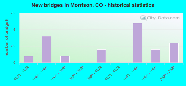
- New bridges - historical statistics
- 11920-1929
- 41930-1939
- 11940-1949
- 21960-1969
- 61980-1989
- 21990-1999
- 32000-2009


- Bridge Condition - Deck
- 25.0%Good
- 41.7%Satisfactory
- 33.3%Fair

- Bridge Condition - Superstructure
- 8.3%Good
- 41.7%Satisfactory
- 50.0%Fair

- Bridge Condition - Substructure
- 8.3%Good
- 75.0%Satisfactory
- 16.7%Fair

- Bridge Condition - Channel
- 50.0%Very good
- 33.3%Good
- 16.7%Satisfactory

- Bridge Condition - Culverts
- 33.3%Good
- 66.7%Satisfactory
Find on map >> Show street view
Structure Number: F-16-AO, Location: IN MORRISON (Lat: 39.653647, Lng: -105.195233), Route carried "on" structure: State highway 8A, Year Built: 1934, Status: Open, Structure Length: 0.68m (2.23ft), Average Daily Traffic: 4,000 (year 2020), Truck Traffic: 2%, Average Future Daily Traffic: 4,640 (year 2040), Design Load: H 15, Features Intersected: DRAW, Facility Carried by Structure: SH 8 ML
Minimum Vertical Clearance: 30+ m (98+ ft), Kilometerpoint: 3.663, Lanes on structure: 2, Base Highway Network: Yes, Owner: State Highway Agency, Approaching Roadway Width: 11.3m (37.1ft), Skew: 2 degrees, Material/Design: Concrete, Design/Construction: Culvert, Number Of Spans In Main Unit: 2, Length of Maximum Span: 3.3m (10.8ft), Out-to-Out Width: 24.4m (80.1ft)
Condition: Channel: Good, Culverts: Satisfactory, Operating Rating: 89.8 metric tons, Method Used To Determine Operating Rating: Field evaluation and documented engineering judgment, Inventory Rating: 89.8 metric tons, Method Used To Determine Inventory Rating: Field evaluation and documented engineering judgment, Structural Evaluation: Equal to present minimum criteria, Waterway Adequacy: Equal to present desirable criteria, Approach Roadway Alignment: Equal to present minimum criteria, Designated Inspection Frequency: Every 24 months, Inspection Date: September 2020
Find on map >> Show street view
Structure Number: F-16-AW, Location: 0.75 MI S OF MORRISON (Lat: 39.641500, Lng: -105.193600), Route carried "on" structure: State highway 8A, Year Built: 1935, Status: Open, Structure Length: 1.01m (3.31ft), Average Daily Traffic: 4,000 (year 2020), Truck Traffic: 2%, Average Future Daily Traffic: 4,640 (year 2040), Design Load: H 15, Features Intersected: STRAINS GULCH, Facility Carried by Structure: SH 8 ML
Minimum Vertical Clearance: 30+ m (98+ ft), Kilometerpoint: 2.261, Lanes on structure: 2, Base Highway Network: Yes, Owner: State Highway Agency, Approaching Roadway Width: 7.6m (24.9ft), Material/Design: Steel, Design/Construction: Stringer/Multi-beam, Number Of Spans In Main Unit: 1, Length of Maximum Span: 9.1m (29.9ft), Curb-To-Curb Width: 9.1m (29.9ft), Out-to-Out Width: 10.2m (33.5ft)
Condition: Deck: Fair, Superstructure: Fair, Substructure: Satisfactory, Channel: Good, Operating Rating: 31.8 metric tons, Method Used To Determine Operating Rating: Load Factor (LF), Inventory Rating: 19.1 metric tons, Method Used To Determine Inventory Rating: Load Factor (LF), Structural Evaluation: Somewhat better than minimum adequacy, Deck Geometry: Meets minimum limits, Waterway Adequacy: Superior to present desirable criteria, Approach Roadway Alignment: Equal to present desirable criteria, Designated Inspection Frequency: Every 24 months, Inspection Date: September 2020, Deck Structure Type: Concrete Cast-file-Place, Wearing Surface/Protective System: Wearing Surface: Bituminous
Find on map >> Show street view
Structure Number: F-16-AX, Location: SOUTH OF MORRISON (Lat: 39.639642, Lng: -105.193486), Route carried "on" structure: State highway 8A, Year Built: 1935, Status: Open, Structure Length: 0.69m (2.26ft), Average Daily Traffic: 4,000 (year 2020), Truck Traffic: 2%, Average Future Daily Traffic: 4,640 (year 2040), Design Load: H 15, Features Intersected: DRAW, Facility Carried by Structure: SH 8 ML
Minimum Vertical Clearance: 30+ m (98+ ft), Kilometerpoint: 2.057, Lanes on structure: 2, Owner: State Highway Agency, Approaching Roadway Width: 7.3m (24.0ft), Skew: 1 degrees, Material/Design: Concrete, Design/Construction: Slab, Number Of Spans In Main Unit: 1, Length of Maximum Span: 6.4m (21.0ft), Curb-To-Curb Width: 9.1m (29.9ft), Out-to-Out Width: 10.2m (33.5ft)
Condition: Deck: Fair, Superstructure: Fair, Substructure: Satisfactory, Channel: Good, Operating Rating: 50.7 metric tons, Method Used To Determine Operating Rating: Load Factor (LF), Inventory Rating: 30.4 metric tons, Method Used To Determine Inventory Rating: Load Factor (LF), Structural Evaluation: Somewhat better than minimum adequacy, Deck Geometry: Meets minimum limits, Waterway Adequacy: Equal to present desirable criteria, Approach Roadway Alignment: Equal to present desirable criteria, Designated Inspection Frequency: Every 24 months, Inspection Date: September 2020, Deck Structure Type: Concrete Cast-file-Place, Wearing Surface/Protective System: Wearing Surface: Bituminous
Find on map >> Show street view
Structure Number: F-16-FB, Location: 2 MI SOUTH OF MORRISON (Lat: 39.624100, Lng: -105.192500), Route carried "on" structure: State highway 8A, Year Built: 1967, Status: Open, Structure Length: 5.64m (18.50ft), Average Daily Traffic: 3,800 (year 2020), Truck Traffic: 13%, Average Future Daily Traffic: 4,180 (year 2040), Design Load: HS 20+Mod, Features Intersected: US 285 ML, Facility Carried by Structure: SH 8 ML
Minimum Vertical Clearance: 30+ m (98+ ft), Kilometerpoint: 0.317, Lanes on structure: 2, Lanes under structure: 5, Base Highway Network: Yes, Owner: State Highway Agency, Approaching Roadway Width: 8.2m (26.9ft), Skew: 1 degrees, Material/Design: Concrete continuous, Design/Construction: Tee Beam, Number Of Spans In Main Unit: 4, Length of Maximum Span: 17.1m (56.1ft), Curb-To-Curb Width: 12.8m (42.0ft), Out-to-Out Width: 14.0m (45.9ft)
Condition: Deck: Fair, Superstructure: Fair, Substructure: Fair, Operating Rating: 51.7 metric tons, Method Used To Determine Operating Rating: Load Factor (LF), Inventory Rating: 30.9 metric tons, Method Used To Determine Inventory Rating: Load Factor (LF), Structural Evaluation: Somewhat better than minimum adequacy, Deck Geometry: Equal to present minimum criteria, Underclear: Meets minimum limits, Approach Roadway Alignment: Equal to present minimum criteria, Designated Inspection Frequency: Every 24 months, Inspection Date: August 2020, Deck Structure Type: Concrete Cast-file-Place, Wearing Surface/Protective System: Wearing Surface: Bituminous, Membrane: Preformed Fabric
Find on map >> Show street view
Structure Number: F-16-LB, Location: 2 MI N OF JCT US 285 (Lat: 39.661742, Lng: -105.184683), Route carried "on" structure: State highway 470A, Year Built: 1988, Status: Open, Structure Length: 4.57m (14.99ft), Average Daily Traffic: 70,000 (year 2020), Truck Traffic: 2%, Average Future Daily Traffic: 93,800 (year 2040), Design Load: HS 20+Mod, Features Intersected: E. FR ROAD/ROONEY ROAD, Facility Carried by Structure: SH470 ML
Minimum Vertical Clearance: 30+ m (98+ ft), Kilometerpoint: 5.961, Lanes on structure: 6, Lanes under structure: 2, Base Highway Network: Yes, Owner: State Highway Agency, Approaching Roadway Width: 32.9m (107.9ft), Skew: 30 degrees, Material/Design: Prestressed concrete continuous, Design/Construction: Stringer/Multi-beam, Number Of Spans In Main Unit: 3, Length of Maximum Span: 26.0m (85.3ft), Curb-To-Curb Width: 32.9m (107.9ft), Out-to-Out Width: 34.6m (113.5ft)
Condition: Deck: Good, Superstructure: Satisfactory, Substructure: Satisfactory, Operating Rating: 46.0 metric tons, Method Used To Determine Operating Rating: Load Factor (LF), Inventory Rating: 27.6 metric tons, Method Used To Determine Inventory Rating: Load Factor (LF), Structural Evaluation: Equal to present minimum criteria, Deck Geometry: Superior to present desirable criteria, Underclear: Superior to present desirable criteria, Approach Roadway Alignment: Equal to present desirable criteria, Designated Inspection Frequency: Every 24 months, Inspection Date: December 2021, Deck Structure Type: Concrete Cast-file-Place, Wearing Surface/Protective System: Wearing Surface: Bituminous, Membrane: Preformed Fabric
Find on map >> Show street view
Structure Number: F-16-LC, Location: MORRISON RD. INTERCHANGE (Lat: 39.653972, Lng: -105.181258), Route carried "on" structure: State highway 470A, Year Built: 1989, Status: Open, Structure Length: 23.32m (76.51ft), Average Daily Traffic: 35,000 (year 2020), Truck Traffic: 2%, Average Future Daily Traffic: 46,900 (year 2040), Design Load: HS 20+Mod, Features Intersected: SH 8, BEAR CREEK, Facility Carried by Structure: SH 470 ML NBND
Minimum Vertical Clearance: 30+ m (98+ ft), Kilometerpoint: 6.883, Lanes on structure: 2, Lanes under structure: 6, Base Highway Network: Yes, Owner: State Highway Agency, Approaching Roadway Width: 11.6m (38.1ft), Skew: 1 degrees, Material/Design: Prestressed concrete continuous, Design/Construction: Box Beam or Girders - Multiple, Number Of Spans In Main Unit: 4, Length of Maximum Span: 67.0m (219.8ft), Curb-To-Curb Width: 11.6m (38.1ft), Out-to-Out Width: 12.6m (41.3ft)
Condition: Deck: Satisfactory, Superstructure: Satisfactory, Substructure: Satisfactory, Channel: Very good, Inventory Rating: 64.3 metric tons, Method Used To Determine Inventory Rating: Load Factor (LF), Structural Evaluation: Equal to present minimum criteria, Deck Geometry: Equal to present minimum criteria, Underclear: Superior to present desirable criteria, Waterway Adequacy: Superior to present desirable criteria, Approach Roadway Alignment: Equal to present desirable criteria, Designated Inspection Frequency: Every 24 months, Inspection Date: December 2021, Deck Structure Type: Concrete Cast-file-Place, Wearing Surface/Protective System: Wearing Surface: Bituminous, Deck Protection: Cathodic Protection
Find on map >> Show street view
Structure Number: F-16-LD, Location: MORRISON RD. INTERCHANGE (Lat: 39.653892, Lng: -105.181511), Route carried "on" structure: State highway 470A, Year Built: 1989, Status: Open, Structure Length: 23.31m (76.48ft), Average Daily Traffic: 35,000 (year 2020), Truck Traffic: 2%, Average Future Daily Traffic: 46,900 (year 2040), Design Load: HS 20+Mod, Features Intersected: SH 8, BEAR CREEK, Facility Carried by Structure: SH 470 ML SBND
Minimum Vertical Clearance: 30+ m (98+ ft), Kilometerpoint: 6.891, Lanes on structure: 2, Lanes under structure: 6, Base Highway Network: Yes, Owner: State Highway Agency, Approaching Roadway Width: 11.6m (38.1ft), Skew: 1 degrees, Material/Design: Prestressed concrete continuous, Design/Construction: Box Beam or Girders - Multiple, Number Of Spans In Main Unit: 4, Length of Maximum Span: 67.1m (220.1ft), Curb-To-Curb Width: 11.6m (38.1ft), Out-to-Out Width: 12.6m (41.3ft)
Condition: Deck: Satisfactory, Superstructure: Satisfactory, Substructure: Satisfactory, Channel: Very good, Inventory Rating: 66.0 metric tons, Method Used To Determine Inventory Rating: Load Factor (LF), Structural Evaluation: Equal to present minimum criteria, Deck Geometry: Equal to present minimum criteria, Underclear: Better than present minimum criteria, Waterway Adequacy: Superior to present desirable criteria, Approach Roadway Alignment: Equal to present desirable criteria, Designated Inspection Frequency: Every 24 months, Inspection Date: December 2021, Deck Structure Type: Other, Wearing Surface/Protective System: Wearing Surface: Bituminous, Deck Protection: Epoxy Coated Reinforcing
Find on map >> Show street view
Structure Number: F-16-LF, Location: SW CRNR OF MORRISON RD.IN (Lat: 39.652422, Lng: -105.181603), Route carried "on" structure: Ramp State highway 470A, Year Built: 1989, Status: Open, Structure Length: 7.47m (24.51ft), Average Daily Traffic: 39,500 (year 2020), Truck Traffic: 2%, Average Future Daily Traffic: 52,140 (year 2040), Design Load: HS 20, Features Intersected: BEAR CREEK R, Facility Carried by Structure: RAMP TO SH 470 EBD
Minimum Vertical Clearance: 30+ m (98+ ft), Kilometerpoint: 0.481, Lanes on structure: 2, Base Highway Network: Yes, Owner: State Highway Agency, Approaching Roadway Width: 11.0m (36.1ft), Skew: 1 degrees, Material/Design: Prestressed concrete continuous, Design/Construction: Stringer/Multi-beam, Number Of Spans In Main Unit: 2, Length of Maximum Span: 36.6m (120.1ft), Curb-To-Curb Width: 11.0m (36.1ft), Out-to-Out Width: 12.0m (39.4ft)
Condition: Deck: Satisfactory, Superstructure: Good, Substructure: Good, Channel: Very good, Operating Rating: 41.2 metric tons, Method Used To Determine Operating Rating: Load Factor (LF), Inventory Rating: 24.7 metric tons, Method Used To Determine Inventory Rating: Load Factor (LF), Structural Evaluation: Equal to present minimum criteria, Deck Geometry: Better than present minimum criteria, Waterway Adequacy: Superior to present desirable criteria, Approach Roadway Alignment: Equal to present desirable criteria, Designated Inspection Frequency: Every 24 months, Inspection Date: December 2021, Deck Structure Type: Concrete Cast-file-Place, Wearing Surface/Protective System: Wearing Surface: Bituminous, Deck Protection: Epoxy Coated Reinforcing
Find on map >> Show street view
Structure Number: F-16-SA, Location: AT INDIAN HILLS RD INTERS (Lat: 39.615881, Lng: -105.232106), Route carried "on" structure: US 285D, Year Built: 1993, Status: Open, Structure Length: 0.64m (2.10ft), Average Daily Traffic: 27,000 (year 2020), Truck Traffic: 3%, Average Future Daily Traffic: 34,020 (year 2040), Design Load: HS 20, Features Intersected: PARMALEE GULCH, Facility Carried by Structure: US 285 ML & RAMP
Minimum Vertical Clearance: 30+ m (98+ ft), Kilometerpoint: 135.063, Lanes on structure: 6, Base Highway Network: Yes, Owner: State Highway Agency, Approaching Roadway Width: 30.8m (101.0ft), Material/Design: Concrete, Design/Construction: Culvert, Number Of Spans In Main Unit: 2, Length of Maximum Span: 3.0m (9.8ft)
Condition: Channel: Very good, Culverts: Satisfactory, Operating Rating: 89.8 metric tons, Method Used To Determine Operating Rating: Field evaluation and documented engineering judgment, Inventory Rating: 89.8 metric tons, Method Used To Determine Inventory Rating: Field evaluation and documented engineering judgment, Structural Evaluation: Equal to present minimum criteria, Waterway Adequacy: Superior to present desirable criteria, Approach Roadway Alignment: Equal to present desirable criteria, Designated Inspection Frequency: Every 48 months, Inspection Date: August 2019
Find on map >> Show street view
Structure Number: F-16-SH, Location: 0.3 MI E OF JCT SH 8 (Lat: 39.625714, Lng: -105.188950), Route carried "on" structure: US 285D, Year Built: 2008, Status: Open, Structure Length: 2.93m (9.61ft), Average Daily Traffic: 39,000 (year 2020), Truck Traffic: 5%, Average Future Daily Traffic: 50,700 (year 2040), Design Load: HS 25 or greater, Features Intersected: WILLOW SPRINGS ROAD, Facility Carried by Structure: US 285 ML
Minimum Vertical Clearance: 30+ m (98+ ft), Kilometerpoint: 139.445, Lanes on structure: 4, Lanes under structure: 2, Base Highway Network: Yes, Owner: State Highway Agency, Approaching Roadway Width: 24.7m (81.0ft), Skew: 31 degrees, Material/Design: Prestressed concrete, Design/Construction: Stringer/Multi-beam, Number Of Spans In Main Unit: 1, Length of Maximum Span: 28.5m (93.5ft), Curb-To-Curb Width: 24.7m (81.0ft), Out-to-Out Width: 26.2m (86.0ft)
Condition: Deck: Good, Superstructure: Satisfactory, Substructure: Satisfactory, Operating Rating: 61.6 metric tons, Method Used To Determine Operating Rating: Load Factor (LF), Inventory Rating: 26.1 metric tons, Method Used To Determine Inventory Rating: Load Factor (LF), Structural Evaluation: Equal to present minimum criteria, Deck Geometry: Superior to present desirable criteria, Approach Roadway Alignment: Equal to present desirable criteria, Length Of Structure Improvement: 3.97m (13.02ft), Designated Inspection Frequency: Every 24 months, Inspection Date: June 2021, Bridge Improvement Cost: $1,565,000, Roadway Improvement Cost: $157,000, Total Project Cost: $2,348,000, Deck Structure Type: Concrete Precast Panels, Wearing Surface/Protective System: Wearing Surface: Bituminous, Membrane: Built-up, Deck Protection: Epoxy Coated Reinforcing
Find on map >> Show street view
Structure Number: F-16-SR, Location: IN MORRISON (Lat: 39.653344, Lng: -105.195200), Route carried "on" structure: State highway 8A, Year Built: 1993, Status: Open, Structure Length: 4.50m (14.76ft), Average Daily Traffic: 4,000 (year 2020), Truck Traffic: 2%, Average Future Daily Traffic: 4,640 (year 2040), Design Load: HS 20, Features Intersected: BEAR CREEK, Facility Carried by Structure: SH 8 ML
Minimum Vertical Clearance: 30+ m (98+ ft), Kilometerpoint: 3.579, Lanes on structure: 2, Base Highway Network: Yes, Owner: State Highway Agency, Approaching Roadway Width: 12.8m (42.0ft), Material/Design: Prestressed concrete, Design/Construction: Box Beam or Girders - Multiple, Number Of Spans In Main Unit: 1, Length of Maximum Span: 44.2m (145.0ft), Curb or Sidewalk Widths: Left: 1.5m (4.9ft), Right: 0.0m, Curb-To-Curb Width: 13.7m (44.9ft), Out-to-Out Width: 16.2m (53.1ft)
Condition: Deck: Satisfactory, Superstructure: Satisfactory, Substructure: Satisfactory, Channel: Very good, Operating Rating: 65.9 metric tons, Method Used To Determine Operating Rating: Load Factor (LF), Inventory Rating: 39.6 metric tons, Method Used To Determine Inventory Rating: Load Factor (LF), Structural Evaluation: Equal to present minimum criteria, Deck Geometry: Superior to present desirable criteria, Waterway Adequacy: Superior to present desirable criteria, Approach Roadway Alignment: Equal to present minimum criteria, Designated Inspection Frequency: Every 24 months, Inspection Date: September 2020, Deck Structure Type: Concrete Cast-file-Place, Wearing Surface/Protective System: Wearing Surface: Epoxy Overlay, Membrane: Epoxy, Deck Protection: Epoxy Coated Reinforcing
Find on map >> Show street view
Structure Number: F-17-12A, Location: .2 MI SOUTH OF US285 (Lat: 39.622536, Lng: -105.187792), Route carried "on" structure: County highway , Year Built: 2001, Status: Open, Structure Length: 0.73m (2.40ft), Average Daily Traffic: 1,497 (year 2021), Truck Traffic: 4%, Average Future Daily Traffic: 1,721 (year 2041), Design Load: HS 20, Features Intersected: TURKEY CREEK, Facility Carried by Structure: WILLOW SPRINGS RD
Minimum Vertical Clearance: 30+ m (98+ ft), Kilometerpoint: 0.842, Lanes on structure: 2, Owner: County Highway Agency, Approaching Roadway Width: 7.6m (24.9ft), Skew: 3 degrees, Material/Design: Concrete, Design/Construction: Culvert, Number Of Spans In Main Unit: 2, Length of Maximum Span: 3.5m (11.5ft), Curb-To-Curb Width: 12.6m (41.3ft), Out-to-Out Width: 14.1m (46.3ft)
Condition: Channel: Satisfactory, Culverts: Good, Operating Rating: 75.2 metric tons, Method Used To Determine Operating Rating: Load Factor (LF), Inventory Rating: 45.1 metric tons, Method Used To Determine Inventory Rating: Load Factor (LF), Structural Evaluation: Better than present minimum criteria, Deck Geometry: Better than present minimum criteria, Waterway Adequacy: Better than present minimum criteria, Approach Roadway Alignment: Equal to present desirable criteria, Designated Inspection Frequency: Every 24 months, Inspection Date: March 2021
Find on map >> Show street view
Structure Number: F-18-68, Location: SODA LAKES RD S OFSH 8 (Lat: 39.651328, Lng: -105.184100), Route carried "on" structure: County highway , Year Built: 1938, Status: Open, Structure Length: 1.81m (5.94ft), Average Daily Traffic: 291 (year 2021), Average Future Daily Traffic: 335 (year 2041), Features Intersected: BEAR CREEK, Facility Carried by Structure: SODA LAKES ROAD
Minimum Vertical Clearance: 30+ m (98+ ft), Kilometerpoint: 0.596, Lanes on structure: 2, Owner: County Highway Agency, Approaching Roadway Width: 7.0m (23.0ft), Skew: 2 degrees, Material/Design: Steel, Design/Construction: Stringer/Multi-beam, Number Of Spans In Main Unit: 2, Length of Maximum Span: 8.8m (28.9ft), Curb-To-Curb Width: 8.8m (28.9ft), Out-to-Out Width: 9.4m (30.8ft)
Condition: Deck: Satisfactory, Superstructure: Fair, Substructure: Fair, Channel: Satisfactory, Operating Rating: 31.8 metric tons, Method Used To Determine Operating Rating: Load Factor (LF), Inventory Rating: 19.0 metric tons, Method Used To Determine Inventory Rating: Load Factor (LF), Structural Evaluation: Somewhat better than minimum adequacy, Deck Geometry: Equal to present minimum criteria, Waterway Adequacy: Equal to present desirable criteria, Approach Roadway Alignment: Equal to present desirable criteria, Designated Inspection Frequency: Every 24 months, Inspection Date: March 2021, Deck Structure Type: Concrete Cast-file-Place, Wearing Surface/Protective System: Wearing Surface: Bituminous
Find on map >> Show street view
Structure Number: MORR-CANON ST, Location: AT INTER WITH SH 8 (Lat: 39.654250, Lng: -105.194583), Route carried "on" structure: City street , Year Built: 1945, Status: Posted for load, Structure Length: 1.40m (4.59ft), Average Daily Traffic: 102 (year 2021), Truck Traffic: 4%, Average Future Daily Traffic: 117 (year 2041), Features Intersected: BEAR CREEK, Facility Carried by Structure: CANON STREET
Minimum Vertical Clearance: 30+ m (98+ ft), Kilometerpoint: 0.013, Lanes on structure: 2, Owner: City or Municipal Highway Agency, Approaching Roadway Width: 6.9m (22.6ft), Skew: 1 degrees, Material/Design: Concrete, Design/Construction: Tee Beam, Number Of Spans In Main Unit: 1, Length of Maximum Span: 13.1m (43.0ft), Curb-To-Curb Width: 6.1m (20.0ft), Out-to-Out Width: 6.8m (22.3ft)
Condition: Deck: Fair, Superstructure: Fair, Substructure: Satisfactory, Channel: Very good, Operating Rating: 27.2 metric tons, Method Used To Determine Operating Rating: Field evaluation and documented engineering judgment, Inventory Rating: 16.3 metric tons, Method Used To Determine Inventory Rating: Field evaluation and documented engineering judgment, Structural Evaluation: Somewhat better than minimum adequacy, Deck Geometry: Meets minimum limits, Waterway Adequacy: Equal to present desirable criteria, Approach Roadway Alignment: Equal to present minimum criteria, Bridge Posting: Required (Relationship of Operating Rating to Maximum Legal Load: 0.1 - 9.9% below), Designated Inspection Frequency: Every 24 months, Inspection Date: April 2021, Deck Structure Type: Concrete Cast-file-Place, Wearing Surface/Protective System: Wearing Surface: Bituminous
Find on map >> Show street view
Structure Number: MORR-PARK AVE, Location: AT INTER. WITH SH 8 (Lat: 39.654139, Lng: -105.192892), Route carried "on" structure: City street , Year Built: 1926, Year Reconstructed: 2013, Status: Posted for load, Structure Length: 1.58m (5.18ft), Average Daily Traffic: 220 (year 2021), Truck Traffic: 4%, Average Future Daily Traffic: 253 (year 2041), Design Load: HS 20, Features Intersected: BEAR CREEK, Facility Carried by Structure: PARK AVENUE
Minimum Vertical Clearance: 30+ m (98+ ft), Kilometerpoint: 0.049, Lanes on structure: 1, Owner: City or Municipal Highway Agency, Approaching Roadway Width: 6.1m (20.0ft), Material/Design: Steel, Design/Construction: Truss - Thru, Number Of Spans In Main Unit: 1, Length of Maximum Span: 14.6m (47.9ft), Curb-To-Curb Width: 3.7m (12.1ft), Out-to-Out Width: 4.3m (14.1ft)
Condition: Deck: Good, Superstructure: Fair, Substructure: Satisfactory, Channel: Good, Operating Rating: 10.9 metric tons, Method Used To Determine Operating Rating: Load Factor (LF), Inventory Rating: 6.5 metric tons, Method Used To Determine Inventory Rating: Load Factor (LF), Structural Evaluation: High priority of corrective action, Deck Geometry: High priority of replacement, Waterway Adequacy: Equal to present desirable criteria, Approach Roadway Alignment: Equal to present desirable criteria, Bridge Posting: Required (Relationship of Operating Rating to Maximum Legal Load: > 39.9% below), Designated Inspection Frequency: Every 24 months, Critical Feature Inspection Frequency: Every 24 months, Inspection Date: April 2021, Critical Feature Inspection Date: April 2021, Deck Structure Type: Wood or Timber, Wearing Surface/Protective System: Wearing Surface: Wood or Timber
Find on map >> Show street view
Structure Number: F-16-FB, Location: 2 MI SOUTH OF MORRISON (Lat: 39.624100, Lng: -105.192500), Route carried "under" structure: US 285D, Year Built: 1967, Structure Length: 0. m, Average Daily Traffic: 29,000 (year 2011), Truck Traffic: 7%, Features Intersected: US 285 ML, Facility Carried by Structure: SH 8 ML
Minimum Vertical Clearance: 5.89m (19.32ft), Kilometerpoint: 399.631, Lanes on structure: 2, Lanes under structure: 5, Material/Design: Concrete continuous, Design/Construction: Tee Beam, Length of Maximum Span: 17.1m (56.1ft)
Find on map >> Show street view
Structure Number: F-16-LC, Location: MORRISON RD. INTERCHANGE (Lat: 39.653972, Lng: -105.181258), Route carried "under" structure: State highway 8A, Year Built: 1989, Structure Length: 0. m, Average Daily Traffic: 11,000 (year 2011), Truck Traffic: 3%, Features Intersected: SH 8, BEAR CREEK, Facility Carried by Structure: SH 470 ML NBND
Minimum Vertical Clearance: 6.02m (19.75ft), Kilometerpoint: 4.639, Lanes on structure: 2, Lanes under structure: 6, Material/Design: Prestressed concrete continuous, Design/Construction: Box Beam or Girders - Multiple, Length of Maximum Span: 67.0m (219.8ft)
Find on map >> Show street view
Structure Number: F-16-LD, Location: MORRISON RD. INTERCHANGE (Lat: 39.653892, Lng: -105.181511), Route carried "under" structure: State highway 8A, Year Built: 1989, Structure Length: 0. m, Average Daily Traffic: 11,000 (year 2011), Truck Traffic: 3%, Features Intersected: SH 8, BEAR CREEK, Facility Carried by Structure: SH 470 ML SBND
Minimum Vertical Clearance: 5.36m (17.59ft), Kilometerpoint: 4.637, Lanes on structure: 2, Lanes under structure: 6, Material/Design: Prestressed concrete continuous, Design/Construction: Box Beam or Girders - Multiple, Length of Maximum Span: 67.1m (220.1ft)
Find on map >> Show street view
Structure Number: F-16-SH, Location: 0.3 MI E OF JCT SH 8 (Lat: 39.625714, Lng: -105.188950), Route carried "under" structure: _, Year Built: 2008, Structure Length: 0. m, Features Intersected: WILLOW SPRINGS ROAD, Facility Carried by Structure: US 285 ML
Minimum Vertical Clearance: 5.41m (17.75ft), Kilometerpoint: 0.000, Lanes on structure: 4, Material/Design: Prestressed concrete, Design/Construction: Stringer/Multi-beam, Length of Maximum Span: 28.5m (93.5ft)