Bridge Statistics for Morrice, Michigan (MI)
Condition, Traffic, Stress, Structural Evaluation, Project Costs
- National Bridge Inventory (NBI) Statistics
- 13Number of bridges
- 82ft / 25.1mTotal length
- $954,000Total costs
- 429,853Total average daily traffic
- 73,119Total average daily truck traffic
- National Bridge Inventory (NBI) Registered Bridges for Morrice
- No street view available for this location
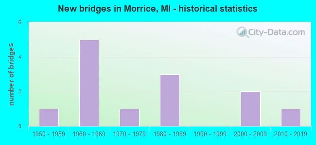
- New bridges - historical statistics
- 11950-1959
- 51960-1969
- 11970-1979
- 31980-1989
- 22000-2009
- 12010-2019


- Bridge Condition - Deck
- 16.7%Very good
- 75.0%Good
- 8.3%Satisfactory

- Bridge Condition - Superstructure
- 16.7%Very good
- 66.7%Good
- 16.7%Satisfactory

- Bridge Condition - Substructure
- 33.3%Very good
- 41.7%Good
- 25.0%Satisfactory

- Bridge Condition - Channel
- 27.3%Very good
- 9.1%Good
- 45.5%Satisfactory
- 18.2%Fair
Find on map >> Show street view
Structure Number: 305, Location: APPROX 0.6 MI N OF 142ND (Lat: 42.731253, Lng: -85.801272), Route carried "on" structure: County highway , Year Built: 1978, Status: Open, Structure Length: 1.13m (3.71ft), Average Daily Traffic: 1,015 (year 2016), Truck Traffic: 7%, Average Future Daily Traffic: 1,500 (year 2036), Design Load: HS 20+Mod, Features Intersected: LITTLE RABBIT RIVER, Facility Carried by Structure: 26TH STREET
Minimum Vertical Clearance: 30.48m (100.00ft), Kilometerpoint: 18.086, Lanes on structure: 2, Owner: County Highway Agency, Approaching Roadway Width: 9.1m (29.9ft), Material/Design: Prestressed concrete, Design/Construction: Box Beam or Girders - Multiple, Number Of Spans In Main Unit: 1, Length of Maximum Span: 11.3m (37.1ft), Curb-To-Curb Width: 8.7m (28.5ft), Out-to-Out Width: 9.3m (30.5ft)
Condition: Deck: Good, Superstructure: Good, Substructure: Satisfactory, Channel: Fair, Operating Rating: 55.4 metric tons, Method Used To Determine Operating Rating: Load Factor (LF) rating reported by rating factor (RF) method using MS18 loading, Inventory Rating: 33.4 metric tons, Method Used To Determine Inventory Rating: Load Factor (LF) rating reported by rating factor (RF) method using MS18 loading, Structural Evaluation: Equal to present minimum criteria, Deck Geometry: Somewhat better than minimum adequacy, Waterway Adequacy: Equal to present desirable criteria, Approach Roadway Alignment: Equal to present desirable criteria, Designated Inspection Frequency: Every 24 months, Inspection Date: April 2021, Deck Structure Type: Concrete Precast Panels, Wearing Surface/Protective System: Wearing Surface: Bituminous, Membrane: Preformed Fabric
Find on map >> Show street view
Structure Number: 4316, Location: 0.2 M N SE COR SEC 10 T13 (Lat: 43.527042, Lng: -84.647553), Route carried "on" structure: County highway 3791, Year Built: 2010, Status: Open, Structure Length: 1.68m (5.51ft), Average Daily Traffic: 1,548 (year 2009), Average Future Daily Traffic: 2,300 (year 2029), Features Intersected: LITTLE SALT RIVER, Facility Carried by Structure: WISE ROAD
Minimum Vertical Clearance: 30.48m (100.00ft), Kilometerpoint: 6.776, Lanes on structure: 2, Owner: County Highway Agency, Approaching Roadway Width: 12.5m (41.0ft), Material/Design: Prestressed concrete, Design/Construction: Box Beam or Girders - Multiple, Number Of Spans In Main Unit: 1, Length of Maximum Span: 16.4m (53.8ft), Curb-To-Curb Width: 12.8m (42.0ft), Out-to-Out Width: 13.4m (44.0ft)
Condition: Deck: Good, Superstructure: Very good, Substructure: Very good, Channel: Very good, Operating Rating: 78.9 metric tons, Method Used To Determine Operating Rating: Load Factor (LF), Inventory Rating: 47.2 metric tons, Method Used To Determine Inventory Rating: Load Factor (LF), Structural Evaluation: Equal to present desirable criteria, Deck Geometry: Better than present minimum criteria, Waterway Adequacy: Better than present minimum criteria, Approach Roadway Alignment: Equal to present desirable criteria, Designated Inspection Frequency: Every 24 months, Inspection Date: July 2020, Deck Structure Type: Concrete Cast-file-Place, Wearing Surface/Protective System: Wearing Surface: Monolithic Concrete, Deck Protection: Epoxy Coated Reinforcing
Find on map >> Show street view
Structure Number: 9732, Location: 5.0 MI NE OF M-52 (Lat: 42.870986, Lng: -84.134369), Route carried "on" structure: Interstate 69, Year Built: 1961, Year Reconstructed: 2010, Status: Open, Structure Length: 1.22m (4.00ft), Average Daily Traffic: 192,000 (year 2011), Truck Traffic: 17%, Average Future Daily Traffic: 21,200 (year 2031), Design Load: HS 20+Mod, Features Intersected: LOOKING GLASS RIVER
Minimum Vertical Clearance: 30.48m (100.00ft), Kilometerpoint: 20.861, Lanes on structure: 2, Base Highway Network: Yes (Inventory Route: 55, Subroute: 8), Owner: State Highway Agency, Approaching Roadway Width: 13.1m (43.0ft), Skew: 10 degrees, Material/Design: Prestressed concrete, Design/Construction: Stringer/Multi-beam, Number Of Spans In Main Unit: 1, Length of Maximum Span: 10.9m (35.8ft), Curb-To-Curb Width: 12.8m (42.0ft), Out-to-Out Width: 14.3m (46.9ft)
Condition: Deck: Good, Superstructure: Satisfactory, Substructure: Satisfactory, Channel: Satisfactory, Operating Rating: 65.8 metric tons, Method Used To Determine Operating Rating: Load Factor (LF) rating reported by rating factor (RF) method using MS18 loading, Inventory Rating: 39.2 metric tons, Method Used To Determine Inventory Rating: Load Factor (LF) rating reported by rating factor (RF) method using MS18 loading, Structural Evaluation: Equal to present minimum criteria, Deck Geometry: Equal to present desirable criteria, Waterway Adequacy: Equal to present desirable criteria, Approach Roadway Alignment: Equal to present desirable criteria, Designated Inspection Frequency: Every 24 months, Inspection Date: July 2021, Deck Structure Type: Concrete Cast-file-Place, Wearing Surface/Protective System: Wearing Surface: Monolithic Concrete, Deck Protection: Epoxy Coated Reinforcing
Find on map >> Show street view
Structure Number: 9733, Location: 5.0 MI NE OF M-52 (Lat: 42.871197, Lng: -84.134608), Route carried "on" structure: Interstate 69, Year Built: 1961, Year Reconstructed: 2010, Status: Open, Structure Length: 1.22m (4.00ft), Average Daily Traffic: 192,000 (year 2011), Truck Traffic: 17%, Average Future Daily Traffic: 212,000 (year 2031), Design Load: HS 20+Mod, Features Intersected: LOOKING GLASS RIVER
Minimum Vertical Clearance: 30.48m (100.00ft), Kilometerpoint: 20.839, Lanes on structure: 2, Base Highway Network: Yes (Inventory Route: 55, Subroute: 9), Owner: State Highway Agency, Approaching Roadway Width: 13.1m (43.0ft), Skew: 10 degrees, Material/Design: Prestressed concrete, Design/Construction: Stringer/Multi-beam, Number Of Spans In Main Unit: 1, Length of Maximum Span: 10.9m (35.8ft), Curb-To-Curb Width: 13.3m (43.6ft), Out-to-Out Width: 14.2m (46.6ft)
Condition: Deck: Good, Superstructure: Satisfactory, Substructure: Satisfactory, Channel: Satisfactory, Operating Rating: 65.8 metric tons, Method Used To Determine Operating Rating: Load Factor (LF) rating reported by rating factor (RF) method using MS18 loading, Inventory Rating: 39.2 metric tons, Method Used To Determine Inventory Rating: Load Factor (LF) rating reported by rating factor (RF) method using MS18 loading, Structural Evaluation: Equal to present minimum criteria, Deck Geometry: Superior to present desirable criteria, Waterway Adequacy: Equal to present desirable criteria, Approach Roadway Alignment: Equal to present desirable criteria, Designated Inspection Frequency: Every 24 months, Inspection Date: July 2021, Deck Structure Type: Concrete Cast-file-Place, Wearing Surface/Protective System: Wearing Surface: Monolithic Concrete, Deck Protection: Epoxy Coated Reinforcing
Find on map >> Show street view
Structure Number: 9746, Location: 2.3 MI NE OF M-52 (Lat: 42.851692, Lng: -84.180953), Route carried "on" structure: County highway 7643, Year Built: 1966, Status: Open, Structure Length: 7.83m (25.69ft), Average Daily Traffic: 2,175 (year 2011), Truck Traffic: 4%, Average Future Daily Traffic: 2,403 (year 2031), Design Load: H 15, Features Intersected: I-69, Facility Carried by Structure: MORRICE RD
Minimum Vertical Clearance: 30.48m (100.00ft), Kilometerpoint: 6.748, Lanes on structure: 2, Lanes under structure: 4, Owner: State Highway Agency, Approaching Roadway Width: 10.3m (33.8ft), Skew: 3 degrees, Material/Design: Steel, Design/Construction: Stringer/Multi-beam, Number Of Spans In Main Unit: 4, Length of Maximum Span: 24.3m (79.7ft), Curb-To-Curb Width: 8.5m (27.9ft), Out-to-Out Width: 10.2m (33.5ft)
Condition: Deck: Satisfactory, Superstructure: Good, Substructure: Good, Operating Rating: 73.9 metric tons, Method Used To Determine Operating Rating: Load Factor (LF) rating reported by rating factor (RF) method using MS18 loading, Inventory Rating: 44.4 metric tons, Method Used To Determine Inventory Rating: Load Factor (LF) rating reported by rating factor (RF) method using MS18 loading, Structural Evaluation: Better than present minimum criteria, Deck Geometry: Meets minimum limits, Underclear: Meets minimum limits, Approach Roadway Alignment: Equal to present desirable criteria, Designated Inspection Frequency: Every 24 months, Inspection Date: June 2021, Deck Structure Type: Concrete Cast-file-Place, Wearing Surface/Protective System: Wearing Surface: Latex Concrete, Deck Protection: Epoxy Coated Reinforcing
Find on map >> Show street view
Structure Number: 9782, Location: 3 MI SW OF BANCROFT (Lat: 42.862106, Lng: -84.125786), Route carried "on" structure: County highway 7628, Year Built: 2007, Status: Open, Structure Length: 1.83m (6.00ft), Average Daily Traffic: 2,568 (year 2011), Truck Traffic: 20%, Average Future Daily Traffic: 3,698 (year 2031), Design Load: HS 20, Features Intersected: LOOKINGGLASS RIVER, Facility Carried by Structure: LANSING ROAD
Minimum Vertical Clearance: 30.48m (100.00ft), Kilometerpoint: 8.232, Lanes on structure: 2, Owner: County Highway Agency, Approaching Roadway Width: 12.2m (40.0ft), Material/Design: Prestressed concrete, Design/Construction: Box Beam or Girders - Multiple, Number Of Spans In Main Unit: 1, Length of Maximum Span: 17.1m (56.1ft), Curb-To-Curb Width: 12.8m (42.0ft), Out-to-Out Width: 13.4m (44.0ft)
Condition: Deck: Very good, Superstructure: Good, Substructure: Very good, Channel: Very good, Operating Rating: 81.0 metric tons, Method Used To Determine Operating Rating: Load Factor (LF) rating reported by rating factor (RF) method using MS18 loading, Inventory Rating: 45.4 metric tons, Method Used To Determine Inventory Rating: Load Factor (LF) rating reported by rating factor (RF) method using MS18 loading, Structural Evaluation: Better than present minimum criteria, Deck Geometry: Equal to present minimum criteria, Waterway Adequacy: Equal to present minimum criteria, Approach Roadway Alignment: Equal to present desirable criteria, Length Of Structure Improvement: 1.83m (6.00ft), Designated Inspection Frequency: Every 24 months, Inspection Date: May 2020, Bridge Improvement Cost: $350,000, Roadway Improvement Cost: $200,000, Total Project Cost: $550,000, Deck Structure Type: Concrete Cast-file-Place, Wearing Surface/Protective System: Wearing Surface: Integral Concrete, Deck Protection: Epoxy Coated Reinforcing
Find on map >> Show street view
Structure Number: 9811, Location: 2 MILES NORTH OF MORRICE (Lat: 42.878567, Lng: -84.182033), Route carried "on" structure: County highway 7643, Year Built: 1952, Status: Posted for load, Structure Length: 1.98m (6.50ft), Average Daily Traffic: 1,534 (year 2011), Truck Traffic: 15%, Average Future Daily Traffic: 2,280 (year 2031), Design Load: H 20, Features Intersected: LOOKINGGLASS RIVER, Facility Carried by Structure: MORRICE ROAD
Minimum Vertical Clearance: 30.48m (100.00ft), Kilometerpoint: 9.734, Lanes on structure: 2, Owner: County Highway Agency, Approaching Roadway Width: 7.9m (25.9ft), Material/Design: Steel, Design/Construction: Stringer/Multi-beam, Number Of Spans In Main Unit: 1, Length of Maximum Span: 18.2m (59.7ft), Curb or Sidewalk Widths: Left: 0.4m (1.3ft), Right: 0.4m (1.3ft), Curb-To-Curb Width: 7.0m (23.0ft), Out-to-Out Width: 8.8m (28.9ft)
Condition: Deck: Good, Superstructure: Good, Substructure: Good, Channel: Fair, Operating Rating: 47.0 metric tons, Method Used To Determine Operating Rating: Load Factor (LF) rating reported by rating factor (RF) method using MS18 loading, Inventory Rating: 28.2 metric tons, Method Used To Determine Inventory Rating: Load Factor (LF) rating reported by rating factor (RF) method using MS18 loading, Structural Evaluation: Better than present minimum criteria, Deck Geometry: High priority of corrective action, Waterway Adequacy: Better than present minimum criteria, Approach Roadway Alignment: Equal to present desirable criteria, Bridge Posting: Required (Relationship of Operating Rating to Maximum Legal Load: 10.0 - 19.9% below), Length Of Structure Improvement: 2.50m (8.20ft), Designated Inspection Frequency: Every 24 months, Inspection Date: April 2020, Bridge Improvement Cost: $325,000, Roadway Improvement Cost: $33,000, Total Project Cost: $404,000, Deck Structure Type: Concrete Cast-file-Place, Wearing Surface/Protective System: Wearing Surface: Bituminous
Find on map >> Show street view
Structure Number: 9824, Location: 3.5 MI SE OF MORRICE (Lat: 42.813408, Lng: -84.121158), Route carried "on" structure: County highway , Year Built: 1985, Status: Posted for load, Structure Length: 1.52m (4.99ft), Average Daily Traffic: 41 (year 1998), Truck Traffic: 5%, Average Future Daily Traffic: 75 (year 2018), Design Load: HS 20+Mod, Features Intersected: LOOKINGGLASS RIVER, Facility Carried by Structure: ELLSWORTH RD
Minimum Vertical Clearance: 30.48m (100.00ft), Kilometerpoint: 0.715, Lanes on structure: 2, Owner: County Highway Agency, Approaching Roadway Width: 10.1m (33.1ft), Skew: 2 degrees, Material/Design: Prestressed concrete, Design/Construction: Box Beam or Girders - Multiple, Number Of Spans In Main Unit: 1, Length of Maximum Span: 14.0m (45.9ft), Curb-To-Curb Width: 9.8m (32.2ft), Out-to-Out Width: 10.0m (32.8ft)
Condition: Deck: Good, Superstructure: Good, Substructure: Very good, Channel: Very good, Operating Rating: 50.5 metric tons, Method Used To Determine Operating Rating: Load Factor (LF) rating reported by rating factor (RF) method using MS18 loading, Inventory Rating: 30.1 metric tons, Method Used To Determine Inventory Rating: Load Factor (LF) rating reported by rating factor (RF) method using MS18 loading, Structural Evaluation: Better than present minimum criteria, Deck Geometry: Equal to present desirable criteria, Waterway Adequacy: Equal to present desirable criteria, Approach Roadway Alignment: Equal to present desirable criteria, Bridge Posting: Required (Relationship of Operating Rating to Maximum Legal Load: 0.1 - 9.9% below), Designated Inspection Frequency: Every 24 months, Inspection Date: May 2020, Deck Structure Type: Concrete Precast Panels, Wearing Surface/Protective System: Wearing Surface: Bituminous, Membrane: Preformed Fabric, Deck Protection: Epoxy Coated Reinforcing
Find on map >> Show street view
Structure Number: 9826, Location: 3.4 MI NE OF MORRICE (Lat: 42.859200, Lng: -84.121953), Route carried "on" structure: County highway , Year Built: 2001, Status: Open, Structure Length: 1.42m (4.66ft), Average Daily Traffic: 238 (year 2000), Truck Traffic: 5%, Average Future Daily Traffic: 354 (year 2020), Design Load: HS 20, Features Intersected: LOOKINGGLASS RIVER, Facility Carried by Structure: STATE RD
Minimum Vertical Clearance: 30.48m (100.00ft), Kilometerpoint: 0.249, Lanes on structure: 2, Owner: County Highway Agency, Approaching Roadway Width: 7.9m (25.9ft), Material/Design: Prestressed concrete, Design/Construction: Box Beam or Girders - Multiple, Number Of Spans In Main Unit: 1, Length of Maximum Span: 14.2m (46.6ft), Curb-To-Curb Width: 7.9m (25.9ft), Out-to-Out Width: 8.6m (28.2ft)
Condition: Deck: Very good, Superstructure: Very good, Substructure: Very good, Channel: Satisfactory, Operating Rating: 61.2 metric tons, Method Used To Determine Operating Rating: Load Factor (LF) rating reported by rating factor (RF) method using MS18 loading, Inventory Rating: 36.6 metric tons, Method Used To Determine Inventory Rating: Load Factor (LF) rating reported by rating factor (RF) method using MS18 loading, Structural Evaluation: Equal to present desirable criteria, Deck Geometry: Somewhat better than minimum adequacy, Waterway Adequacy: Superior to present desirable criteria, Approach Roadway Alignment: Equal to present desirable criteria, Designated Inspection Frequency: Every 24 months, Inspection Date: May 2020, Deck Structure Type: Concrete Cast-file-Place, Wearing Surface/Protective System: Wearing Surface: Monolithic Concrete, Deck Protection: Epoxy Coated Reinforcing
Find on map >> Show street view
Structure Number: 983, Location: 5 MI SE OF BENNINGTON (Lat: 42.885475, Lng: -84.172225), Route carried "on" structure: County highway , Year Built: 1989, Status: Posted for load, Structure Length: 1.98m (6.50ft), Average Daily Traffic: 126 (year 2015), Truck Traffic: 5%, Average Future Daily Traffic: 188 (year 2035), Design Load: HS 20, Features Intersected: LOOKINGGLASS RIVER, Facility Carried by Structure: GALE RD
Minimum Vertical Clearance: 30.48m (100.00ft), Kilometerpoint: 1.511, Lanes on structure: 2, Owner: County Highway Agency, Approaching Roadway Width: 10.6m (34.8ft), Skew: 1 degrees, Material/Design: Prestressed concrete, Design/Construction: Box Beam or Girders - Multiple, Number Of Spans In Main Unit: 1, Length of Maximum Span: 18.3m (60.0ft), Curb-To-Curb Width: 10.7m (35.1ft), Out-to-Out Width: 11.4m (37.4ft)
Condition: Deck: Good, Superstructure: Good, Substructure: Good, Channel: Satisfactory, Operating Rating: 51.8 metric tons, Method Used To Determine Operating Rating: Load Factor (LF) rating reported by rating factor (RF) method using MS18 loading, Inventory Rating: 31.1 metric tons, Method Used To Determine Inventory Rating: Load Factor (LF) rating reported by rating factor (RF) method using MS18 loading, Structural Evaluation: Better than present minimum criteria, Deck Geometry: Better than present minimum criteria, Waterway Adequacy: Equal to present desirable criteria, Approach Roadway Alignment: Equal to present desirable criteria, Bridge Posting: Required (Relationship of Operating Rating to Maximum Legal Load: 0.1 - 9.9% below), Designated Inspection Frequency: Every 24 months, Inspection Date: May 2020, Deck Structure Type: Concrete Precast Panels, Wearing Surface/Protective System: Wearing Surface: Bituminous, Membrane: Preformed Fabric
Find on map >> Show street view
Structure Number: 9863, Location: 3.7 MI W OF BANCROFT (Lat: 42.872436, Lng: -84.136039), Route carried "on" structure: County highway , Year Built: 1961, Status: Open, Structure Length: 1.52m (4.99ft), Average Daily Traffic: 170 (year 1998), Truck Traffic: 5%, Average Future Daily Traffic: 310 (year 2018), Design Load: HS 20, Features Intersected: LOOKINGGLASS RIVER, Facility Carried by Structure: TYRRELL RD
Minimum Vertical Clearance: 30.48m (100.00ft), Kilometerpoint: 3.732, Lanes on structure: 2, Owner: County Highway Agency, Approaching Roadway Width: 10.1m (33.1ft), Skew: 3 degrees, Material/Design: Prestressed concrete, Design/Construction: Box Beam or Girders - Multiple, Number Of Spans In Main Unit: 1, Length of Maximum Span: 14.0m (45.9ft), Curb or Sidewalk Widths: Left: 0.7m (2.3ft), Right: 0.7m (2.3ft), Curb-To-Curb Width: 7.0m (23.0ft), Out-to-Out Width: 9.4m (30.8ft)
Condition: Deck: Good, Superstructure: Good, Substructure: Good, Channel: Satisfactory, Operating Rating: 56.1 metric tons, Method Used To Determine Operating Rating: Load Factor (LF) rating reported by rating factor (RF) method using MS18 loading, Inventory Rating: 32.7 metric tons, Method Used To Determine Inventory Rating: Load Factor (LF) rating reported by rating factor (RF) method using MS18 loading, Structural Evaluation: Better than present minimum criteria, Deck Geometry: Meets minimum limits, Waterway Adequacy: Better than present minimum criteria, Approach Roadway Alignment: Equal to present desirable criteria, Designated Inspection Frequency: Every 24 months, Inspection Date: April 2020, Deck Structure Type: Concrete Precast Panels, Wearing Surface/Protective System: Wearing Surface: Bituminous
Find on map >> Show street view
Structure Number: 9865, Location: 4.5 MI W OF BANCROFT (Lat: 42.878772, Lng: -84.152586), Route carried "on" structure: County highway , Year Built: 1985, Status: Open, Structure Length: 1.82m (5.97ft), Average Daily Traffic: 78 (year 1998), Truck Traffic: 5%, Average Future Daily Traffic: 140 (year 2018), Design Load: HS 20, Features Intersected: LOOKINGGLASS RIVER, Facility Carried by Structure: CORK RD
Minimum Vertical Clearance: 30.48m (100.00ft), Kilometerpoint: 1.524, Lanes on structure: 2, Owner: County Highway Agency, Approaching Roadway Width: 10.1m (33.1ft), Material/Design: Prestressed concrete, Design/Construction: Box Beam or Girders - Multiple, Number Of Spans In Main Unit: 1, Length of Maximum Span: 17.0m (55.8ft), Curb-To-Curb Width: 9.1m (29.9ft), Out-to-Out Width: 9.5m (31.2ft)
Condition: Deck: Good, Superstructure: Good, Substructure: Good, Channel: Good, Operating Rating: 71.6 metric tons, Method Used To Determine Operating Rating: Load Factor (LF) rating reported by rating factor (RF) method using MS18 loading, Inventory Rating: 42.8 metric tons, Method Used To Determine Inventory Rating: Load Factor (LF) rating reported by rating factor (RF) method using MS18 loading, Structural Evaluation: Better than present minimum criteria, Deck Geometry: Better than present minimum criteria, Waterway Adequacy: Better than present minimum criteria, Approach Roadway Alignment: Equal to present desirable criteria, Designated Inspection Frequency: Every 24 months, Inspection Date: April 2020, Deck Structure Type: Concrete Precast Panels, Wearing Surface/Protective System: Wearing Surface: Bituminous, Membrane: Preformed Fabric, Deck Protection: Epoxy Coated Reinforcing
Find on map >> Show street view
Structure Number: 9746, Location: 2.3 MI NE OF M-52 (Lat: 42.851692, Lng: -84.180953), Route carried "under" structure: Interstate 69, Year Built: 1966, Structure Length: 0. m, Average Daily Traffic: 36,360 (year 2011), Truck Traffic: 19%, Features Intersected: I-69, Facility Carried by Structure: MORRICE RD
Minimum Vertical Clearance: 4.62m (15.16ft), Kilometerpoint: 16.475, Lanes on structure: 2, Lanes under structure: 4, Material/Design: Steel, Design/Construction: Stringer/Multi-beam, Length of Maximum Span: 24.3m (79.7ft)