Bridge Statistics for Morningside, Maryland (MD)
Condition, Traffic, Stress, Structural Evaluation, Project Costs
- National Bridge Inventory (NBI) Statistics
- 15Number of bridges
- 148ft / 45.4mTotal length
- $3,064,000Total costs
- 764,426Total average daily traffic
- 53,044Total average daily truck traffic
- National Bridge Inventory (NBI) Registered Bridges for Morningside
- No street view available for this location
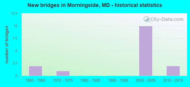
- New bridges - historical statistics
- 21960-1969
- 11970-1979
- 102000-2009
- 22010-2019


- Bridge Condition - Deck
- 71.4%Very good
- 14.3%Good
- 14.3%Satisfactory

- Bridge Condition - Superstructure
- 14.3%Excellent
- 85.7%Very good

- Bridge Condition - Substructure
- 14.3%Excellent
- 85.7%Very good
Find on map >> Show street view
Structure Number: 100000160160015, Location: 0.79 MILE SOUTH OF MD 4 (Lat: 38.829992, Lng: -76.874197), Route carried "on" structure: Interstate 95, Year Built: 1963, Status: Open, Structure Length: 11.95m (39.21ft), Average Daily Traffic: 185,190 (year 2009), Truck Traffic: 8%, Average Future Daily Traffic: 238,750 (year 2029), Design Load: HS 20, Features Intersected: SUITLAND PARKWAY
Minimum Vertical Clearance: 30+ m (98+ ft), Kilometerpoint: 16.010, Lanes on structure: 4, Lanes under structure: 4, Base Highway Network: Yes, Owner: State Highway Agency, Approaching Roadway Width: 20.7m (67.9ft), Skew: 2 degrees, Material/Design: Steel, Design/Construction: Stringer/Multi-beam, Number Of Spans In Main Unit: 7, Length of Maximum Span: 18.9m (62.0ft), Curb-To-Curb Width: 16.5m (54.1ft), Out-to-Out Width: 18.0m (59.1ft)
Condition: Deck: Very good, Superstructure: Very good, Substructure: Very good, Operating Rating: 61.7 metric tons, Method Used To Determine Operating Rating: Load Factor (LF), Inventory Rating: 37.2 metric tons, Method Used To Determine Inventory Rating: Load Factor (LF), Structural Evaluation: Equal to present desirable criteria, Deck Geometry: Meets minimum limits, Underclear: High priority of replacement, Approach Roadway Alignment: Equal to present desirable criteria, Length Of Structure Improvement: 11.95m (39.21ft), Designated Inspection Frequency: Every 24 months, Inspection Date: January 2021, Bridge Improvement Cost: $2,785,000, Roadway Improvement Cost: $278,000, Total Project Cost: $3,064,000, Deck Structure Type: Concrete Cast-file-Place, Wearing Surface/Protective System: Wearing Surface: Bituminous
Find on map >> Show street view
Structure Number: 10000016016201, Location: 0.4 MI SW OF SUITLAND RD (Lat: 0.646994, Lng: -1.281431), Route carried "on" structure: Interstate 495, Year Built: 2016, Status: Open, Structure Length: 4.50m (14.76ft), Average Daily Traffic: 175,200 (year 2009), Truck Traffic: 11%, Average Future Daily Traffic: 200,975 (year 2030), Features Intersected: SUITLAND ROAD
Minimum Vertical Clearance: 30+ m (98+ ft), Kilometerpoint: 14.594, Lanes on structure: 8, Lanes under structure: 4, Base Highway Network: Yes, Owner: State Highway Agency, Approaching Roadway Width: 21.3m (69.9ft), Skew: 12 degrees, Material/Design: Steel, Design/Construction: Stringer/Multi-beam, Number Of Spans In Main Unit: 1, Length of Maximum Span: 36.0m (118.1ft), Curb-To-Curb Width: 26.1m (85.6ft), Out-to-Out Width: 54.3m (178.1ft)
Condition: Deck: Very good, Superstructure: Excellent, Substructure: Excellent, Operating Rating: 50.2 metric tons, Method Used To Determine Operating Rating: Load and Resistance Factor Rating (LRFR) rating reported by rating factor(RF) method using HL-93 loadings, Inventory Rating: 38.9 metric tons, Method Used To Determine Inventory Rating: Load and Resistance Factor Rating (LRFR) rating reported by rating factor(RF) method using HL-93 loadings, Structural Evaluation: Superior to present desirable criteria, Deck Geometry: High priority of replacement, Underclear: High priority of corrective action, Approach Roadway Alignment: Equal to present desirable criteria, Designated Inspection Frequency: Every 24 months, Inspection Date: August 2021, Deck Structure Type: Concrete Cast-file-Place, Wearing Surface/Protective System: Wearing Surface: Integral Concrete, Deck Protection: Epoxy Coated Reinforcing
Find on map >> Show street view
Structure Number: 10000016028601, Location: @ MD 5 INTERCHANGE (Lat: 38.821075, Lng: -76.918103), Route carried "on" structure: Ramp Interstate 95, Year Built: 2008, Status: Open, Structure Length: 3.41m (11.19ft), Average Daily Traffic: 21,741 (year 2012), Truck Traffic: 14%, Average Future Daily Traffic: 31,307 (year 2034), Design Load: HS 25 or greater, Features Intersected: IS 95/IS 495 RAMP 9
Minimum Vertical Clearance: 30+ m (98+ ft), Kilometerpoint: 11.842, Lanes on structure: 1, Lanes under structure: 1, Base Highway Network: Yes, Owner: State Highway Agency, Approaching Roadway Width: 8.8m (28.9ft), Skew: 3 degrees, Material/Design: Steel, Design/Construction: Stringer/Multi-beam, Number Of Spans In Main Unit: 1, Length of Maximum Span: 30.5m (100.1ft), Curb-To-Curb Width: 8.8m (28.9ft), Out-to-Out Width: 10.7m (35.1ft)
Condition: Deck: Very good, Superstructure: Very good, Substructure: Very good, Inventory Rating: 76.6 metric tons, Method Used To Determine Inventory Rating: Load Factor (LF), Structural Evaluation: Equal to present desirable criteria, Deck Geometry: Superior to present desirable criteria, Underclear: Equal to present desirable criteria, Approach Roadway Alignment: Equal to present desirable criteria, Designated Inspection Frequency: Every 24 months, Other Special Inspection Frequency: Every 12 months, Inspection Date: December 2020, Other Special Inspection Date: November 2021, Deck Structure Type: Concrete Cast-file-Place, Wearing Surface/Protective System: Wearing Surface: Monolithic Concrete, Deck Protection: Epoxy Coated Reinforcing
Find on map >> Show street view
Structure Number: 10000016028701, Location: 1.37 MILE SOUTH OF MD 414 (Lat: 38.821347, Lng: -76.920853), Route carried "on" structure: Ramp Interstate 95, Year Built: 2008, Status: Open, Structure Length: 7.47m (24.51ft), Average Daily Traffic: 22,464 (year 2000), Truck Traffic: 8%, Average Future Daily Traffic: 24,261 (year 2020), Design Load: HS 25 or greater, Features Intersected: MD 5
Minimum Vertical Clearance: 30+ m (98+ ft), Kilometerpoint: 19.228, Lanes on structure: 1, Lanes under structure: 7, Base Highway Network: Yes, Owner: State Highway Agency, Approaching Roadway Width: 8.8m (28.9ft), Skew: 1 degrees, Material/Design: Steel, Design/Construction: Stringer/Multi-beam, Number Of Spans In Main Unit: 2, Length of Maximum Span: 36.6m (120.1ft), Curb-To-Curb Width: 8.8m (28.9ft), Out-to-Out Width: 10.1m (33.1ft)
Condition: Deck: Good, Superstructure: Very good, Substructure: Very good, Inventory Rating: 63.0 metric tons, Method Used To Determine Inventory Rating: Load Factor (LF), Structural Evaluation: Equal to present desirable criteria, Deck Geometry: Superior to present desirable criteria, Underclear: High priority of corrective action, Approach Roadway Alignment: Equal to present desirable criteria, Designated Inspection Frequency: Every 24 months, Inspection Date: November 2020, Deck Structure Type: Concrete Cast-file-Place, Wearing Surface/Protective System: Wearing Surface: Monolithic Concrete, Deck Protection: Epoxy Coated Reinforcing
Find on map >> Show street view
Structure Number: 10000016028801, Location: 2.86 MILE NORTH OF MD 414 (Lat: 38.820181, Lng: -76.921439), Route carried "on" structure: Ramp Interstate 95, Year Built: 2008, Status: Open, Structure Length: 9.63m (31.59ft), Average Daily Traffic: 22,464 (year 2000), Truck Traffic: 14%, Average Future Daily Traffic: 24,261 (year 2020), Design Load: HS 25 or greater, Features Intersected: IS 95/ IS 495 & RAMP 5
Minimum Vertical Clearance: 30+ m (98+ ft), Kilometerpoint: 11.585, Lanes on structure: 1, Lanes under structure: 10, Base Highway Network: Yes, Owner: State Highway Agency, Approaching Roadway Width: 8.8m (28.9ft), Skew: 2 degrees, Material/Design: Steel continuous, Design/Construction: Stringer/Multi-beam, Number Of Spans In Main Unit: 2, Length of Maximum Span: 51.8m (169.9ft), Curb-To-Curb Width: 8.8m (28.9ft), Out-to-Out Width: 10.1m (33.1ft)
Condition: Deck: Satisfactory, Superstructure: Very good, Substructure: Very good, Inventory Rating: 70.3 metric tons, Method Used To Determine Inventory Rating: Load Factor (LF), Structural Evaluation: Equal to present desirable criteria, Deck Geometry: Superior to present desirable criteria, Underclear: Equal to present minimum criteria, Approach Roadway Alignment: Equal to present desirable criteria, Designated Inspection Frequency: Every 24 months, Inspection Date: December 2020, Deck Structure Type: Concrete Cast-file-Place, Wearing Surface/Protective System: Wearing Surface: Monolithic Concrete, Deck Protection: Epoxy Coated Reinforcing
Find on map >> Show street view
Structure Number: 10000016028901, Location: 2.97 MILE NORTH OF MD 414 (Lat: 38.818800, Lng: -76.919703), Route carried "on" structure: Ramp Interstate 95, Year Built: 2008, Status: Open, Structure Length: 3.66m (12.01ft), Average Daily Traffic: 16,037 (year 2010), Truck Traffic: 14%, Average Future Daily Traffic: 17,320 (year 2030), Design Load: HS 25 or greater, Features Intersected: IS 95/IS 495 RAMP 5
Minimum Vertical Clearance: 30+ m (98+ ft), Kilometerpoint: 11.746, Lanes on structure: 2, Lanes under structure: 1, Base Highway Network: Yes, Owner: State Highway Agency, Approaching Roadway Width: 13.4m (44.0ft), Material/Design: Steel, Design/Construction: Stringer/Multi-beam, Number Of Spans In Main Unit: 1, Length of Maximum Span: 35.1m (115.2ft), Curb-To-Curb Width: 13.4m (44.0ft), Out-to-Out Width: 14.6m (47.9ft)
Condition: Deck: Very good, Superstructure: Very good, Substructure: Very good, Inventory Rating: 55.8 metric tons, Method Used To Determine Inventory Rating: Load Factor (LF), Structural Evaluation: Equal to present desirable criteria, Deck Geometry: Superior to present desirable criteria, Underclear: Meets minimum limits, Approach Roadway Alignment: Equal to present desirable criteria, Designated Inspection Frequency: Every 24 months, Inspection Date: December 2020, Deck Structure Type: Concrete Cast-file-Place, Wearing Surface/Protective System: Wearing Surface: Monolithic Concrete, Deck Protection: Epoxy Coated Reinforcing
Find on map >> Show street view
Structure Number: 10000016029001, Location: 2.82 MILE NORTH OF MD 414 (Lat: 38.819369, Lng: -76.922097), Route carried "on" structure: Ramp Interstate 95, Year Built: 2006, Status: Open, Structure Length: 2.99m (9.81ft), Average Daily Traffic: 16,037 (year 2010), Truck Traffic: 14%, Average Future Daily Traffic: 17,320 (year 2030), Design Load: HS 25 or greater, Features Intersected: MD 5 RAMP 5
Minimum Vertical Clearance: 30+ m (98+ ft), Kilometerpoint: 0.243, Lanes on structure: 1, Lanes under structure: 1, Base Highway Network: Yes, Owner: State Highway Agency, Approaching Roadway Width: 13.1m (43.0ft), Skew: 1 degrees, Material/Design: Steel, Design/Construction: Stringer/Multi-beam, Number Of Spans In Main Unit: 1, Length of Maximum Span: 28.3m (92.8ft), Curb-To-Curb Width: 8.9m (29.2ft), Out-to-Out Width: 10.2m (33.5ft)
Condition: Deck: Very good, Superstructure: Very good, Substructure: Very good, Inventory Rating: 61.2 metric tons, Method Used To Determine Inventory Rating: Load Factor (LF), Structural Evaluation: Equal to present desirable criteria, Deck Geometry: Superior to present desirable criteria, Underclear: High priority of corrective action, Approach Roadway Alignment: Equal to present desirable criteria, Designated Inspection Frequency: Every 24 months, Inspection Date: December 2020, Deck Structure Type: Concrete Cast-file-Place, Wearing Surface/Protective System: Wearing Surface: Monolithic Concrete, Deck Protection: Epoxy Coated Reinforcing
Find on map >> Show street view
Structure Number: 200000P-030302, Location: .10 MI S OF SUITLAND PKWY (Lat: 38.834514, Lng: -76.901169), Route carried "on" structure: County highway 81, Year Built: 1971, Status: Posted for load, Structure Length: 1.74m (5.71ft), Average Daily Traffic: 18,624 (year 2016), Truck Traffic: 5%, Average Future Daily Traffic: 27,675 (year 2036), Design Load: HS 20, Features Intersected: HENSON CREEK, Facility Carried by Structure: SUITLAND ROAD
Minimum Vertical Clearance: 30+ m (98+ ft), Kilometerpoint: 2.011, Lanes on structure: 2, Owner: County Highway Agency, Approaching Roadway Width: 11.6m (38.1ft), Skew: 12 degrees, Material/Design: Concrete, Design/Construction: Culvert, Number Of Spans In Main Unit: 5, Length of Maximum Span: 4.3m (14.1ft), Curb or Sidewalk Widths: Left: 1.7m (5.6ft), Right: 1.7m (5.6ft)
Condition: Channel: Satisfactory, Culverts: Satisfactory, Operating Rating: 52.6 metric tons, Method Used To Determine Operating Rating: Load Factor (LF), Inventory Rating: 31.3 metric tons, Method Used To Determine Inventory Rating: Load Factor (LF), Structural Evaluation: Equal to present minimum criteria, Waterway Adequacy: Better than present minimum criteria, Approach Roadway Alignment: Equal to present desirable criteria, Bridge Posting: Required (Relationship of Operating Rating to Maximum Legal Load: > 39.9% below), Designated Inspection Frequency: Every 24 months, Inspection Date: January 2021
Find on map >> Show street view
Structure Number: 100000160160015, Location: 0.78 MI S OF MD 4 (Lat: 38.829992, Lng: -76.874197), Route carried "under" structure: Federal lands road 119, Year Built: 1963, Structure Length: 0. m, Average Daily Traffic: 32,790 (year 2009), Features Intersected: SUITLAND PARKWAY, Facility Carried by Structure: IS 95 IL
Minimum Vertical Clearance: 4.88m (16.01ft), Kilometerpoint: 8.833, Lanes on structure: 8, Lanes under structure: 4, Material/Design: Steel, Design/Construction: Stringer/Multi-beam, Length of Maximum Span: 18.9m (62.0ft)
Find on map >> Show street view
Structure Number: 10000016016201, Location: 1.69 MILES S OF MD 4 (Lat: 38.821836, Lng: -76.887753), Route carried "under" structure: County highway 81, Year Built: 2016, Structure Length: 0. m, Average Daily Traffic: 17,015 (year 2006), Features Intersected: SUITLAND ROAD, Facility Carried by Structure: IS 495
Minimum Vertical Clearance: 5.49m (18.01ft), Kilometerpoint: 0.161, Lanes on structure: 8, Lanes under structure: 8, Material/Design: Steel, Design/Construction: Stringer/Multi-beam, Length of Maximum Span: 36.0m (118.1ft)
Find on map >> Show street view
Structure Number: 10000016028601, Location: 3.03 MILE NORTH OF MD 414 (Lat: 38.821075, Lng: -76.918103), Route carried "under" structure: Ramp Interstate 95, Year Built: 2008, Structure Length: 0. m, Average Daily Traffic: 1,511 (year 2012), Truck Traffic: 14%, Features Intersected: IS 95/IS 495 RAMP 9
Minimum Vertical Clearance: 5.49m (18.01ft), Kilometerpoint: 11.842, Lanes on structure: 1, Lanes under structure: 1, Material/Design: Steel, Design/Construction: Stringer/Multi-beam, Length of Maximum Span: 30.5m (100.1ft)
Find on map >> Show street view
Structure Number: 10000016028701, Location: 1.27 MILE NORTH OF MD 337 (Lat: 38.821347, Lng: -76.920853), Route carried "under" structure: State highway 5, Year Built: 2008, Structure Length: 0. m, Average Daily Traffic: 66,772 (year 2009), Truck Traffic: 8%, Features Intersected: MD 5
Minimum Vertical Clearance: 5.49m (18.01ft), Kilometerpoint: 19.228, Lanes on structure: 1, Lanes under structure: 7, Material/Design: Steel, Design/Construction: Stringer/Multi-beam, Length of Maximum Span: 36.6m (120.1ft)
Find on map >> Show street view
Structure Number: 10000016028801, Location: 2.86 MILE NORTH OF MD 414 (Lat: 38.820181, Lng: -76.921439), Route carried "under" structure: Interstate 95, Year Built: 2008, Structure Length: 0. m, Average Daily Traffic: 154,159 (year 2012), Features Intersected: IS 95/ IS 495 & RAMP 5
Minimum Vertical Clearance: 5.79m (19.00ft), Kilometerpoint: 1.158, Lanes on structure: 1, Lanes under structure: 10, Material/Design: Steel continuous, Design/Construction: Stringer/Multi-beam, Length of Maximum Span: 51.8m (169.9ft)
Find on map >> Show street view
Structure Number: 10000016028901, Location: 2.97 MILE NORTH OF MD 414 (Lat: 38.818800, Lng: -76.919703), Route carried "under" structure: Ramp Interstate 95, Year Built: 2008, Structure Length: 0. m, Average Daily Traffic: 7,211 (year 2012), Features Intersected: IS 95/IS 495 RAMP 5
Minimum Vertical Clearance: 6.40m (21.00ft), Kilometerpoint: 11.746, Lanes on structure: 2, Lanes under structure: 1, Material/Design: Steel, Design/Construction: Stringer/Multi-beam, Length of Maximum Span: 35.1m (115.2ft)
Find on map >> Show street view
Structure Number: 10000016029001, Location: 2.82 MILE NORTH OF MD 414 (Lat: 38.819369, Lng: -76.922097), Route carried "under" structure: Ramp Interstate 95, Year Built: 2006, Structure Length: 0. m, Average Daily Traffic: 7,211 (year 2012), Features Intersected: IS 95/IS 495 RAMP 5
Minimum Vertical Clearance: 5.18m (16.99ft), Kilometerpoint: 11.504, Lanes on structure: 1, Lanes under structure: 1, Material/Design: Steel, Design/Construction: Stringer/Multi-beam, Length of Maximum Span: 28.3m (92.8ft)