Bridge Statistics for Morenci, Michigan (MI)
Condition, Traffic, Stress, Structural Evaluation, Project Costs
- National Bridge Inventory (NBI) Statistics
- 17Number of bridges
- 112ft / 34.2mTotal length
- $456,000Total costs
- 32,465Total average daily traffic
- 1,834Total average daily truck traffic
- 50,001Total future (year 2018) average daily traffic
- National Bridge Inventory (NBI) Registered Bridges for Morenci
- No street view available for this location
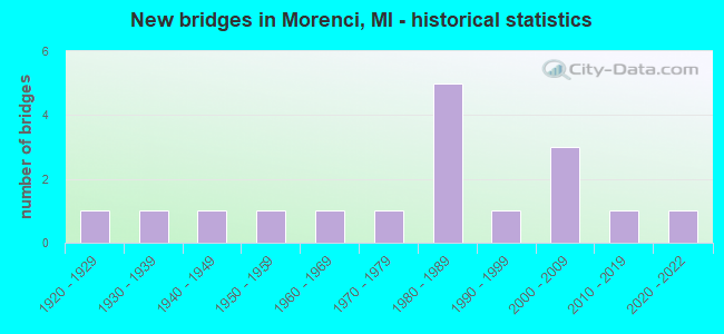
- New bridges - historical statistics
- 11920-1929
- 11930-1939
- 11940-1949
- 11950-1959
- 11960-1969
- 11970-1979
- 51980-1989
- 11990-1999
- 32000-2009
- 12010-2019
- 12020-2022

- Reconstructed bridges - Historical Statistics
- 12000-2009
- 12010-2019


- Bridge Condition - Deck
- 6.7%Excellent
- 20.0%Very good
- 46.7%Good
- 13.3%Satisfactory
- 6.7%Fair
- 6.7%Poor

- Bridge Condition - Superstructure
- 6.7%Excellent
- 33.3%Very good
- 33.3%Good
- 13.3%Fair
- 6.7%Poor
- 6.7%Critical

- Bridge Condition - Substructure
- 6.7%Excellent
- 40.0%Very good
- 33.3%Good
- 6.7%Satisfactory
- 13.3%Fair

- Bridge Condition - Channel
- 17.6%Very good
- 11.8%Good
- 47.1%Satisfactory
- 17.6%Fair
- 5.9%Serious

- Bridge Condition - Culverts
- 50.0%Good
- 50.0%Poor
Find on map >> Show street view
Structure Number: 416, Location: 0.1 MI S OF MI PT 193 (Lat: 44.012508, Lng: -84.041258), Route carried "on" structure: Interstate 75, Year Built: 1968, Status: Open, Structure Length: 0.91m (2.99ft), Average Daily Traffic: 7,138 (year 2007), Truck Traffic: 11%, Average Future Daily Traffic: 9,916 (year 2018), Design Load: HS 20+Mod, Features Intersected: N BRANCH PINE RIVER
Minimum Vertical Clearance: 30.48m (100.00ft), Kilometerpoint: 12.017, Lanes on structure: 2, Base Highway Network: Yes (Inventory Route: 106, Subroute: 1), Owner: State Highway Agency, Approaching Roadway Width: 10.9m (35.8ft), Material/Design: Steel, Design/Construction: Culvert, Number Of Spans In Main Unit: 2, Length of Maximum Span: 3.7m (12.1ft), Curb-To-Curb Width: 10.9m (35.8ft), Out-to-Out Width: 39.8m (130.6ft)
Condition: Channel: Fair, Culverts: Poor, Operating Rating: 97.2 metric tons, Method Used To Determine Operating Rating: Load Factor (LF) rating reported by rating factor (RF) method using MS18 loading, Inventory Rating: 97.2 metric tons, Method Used To Determine Inventory Rating: Load Factor (LF) rating reported by rating factor (RF) method using MS18 loading, Structural Evaluation: Meets minimum limits, Deck Geometry: Meets minimum limits, Waterway Adequacy: Equal to present minimum criteria, Approach Roadway Alignment: Equal to present minimum criteria, Designated Inspection Frequency: Every 12 months, Inspection Date: July 2021
Find on map >> Show street view
Structure Number: 2781, Location: NORTHOFUS-23RAMP (Lat: 42.815100, Lng: -83.727442), Route carried "on" structure: County highway , Year Built: 1928, Status: Posted for load, Structure Length: 1.06m (3.48ft), Average Daily Traffic: 5,647 (year 2008), Truck Traffic: 2%, Average Future Daily Traffic: 10,199 (year 2028), Design Load: HS 20+Mod, Features Intersected: SHIAWASSEE RIVER, Facility Carried by Structure: NORTH ROAD
Minimum Vertical Clearance: 30.48m (100.00ft), Kilometerpoint: 3.098, Lanes on structure: 2, Owner: County Highway Agency, Approaching Roadway Width: 11.0m (36.1ft), Material/Design: Steel, Design/Construction: Stringer/Multi-beam, Number Of Spans In Main Unit: 1, Length of Maximum Span: 10.3m (33.8ft), Curb-To-Curb Width: 9.1m (29.9ft), Out-to-Out Width: 10.8m (35.4ft)
Condition: Deck: Satisfactory, Superstructure: Poor, Substructure: Satisfactory, Channel: Satisfactory, Operating Rating: 6.8 metric tons, Method Used To Determine Operating Rating: Load Factor (LF) rating reported by rating factor (RF) method using MS18 loading, Inventory Rating: 4.2 metric tons, Method Used To Determine Inventory Rating: Load Factor (LF) rating reported by rating factor (RF) method using MS18 loading, Structural Evaluation: High priority of corrective action, Deck Geometry: High priority of corrective action, Waterway Adequacy: Equal to present desirable criteria, Approach Roadway Alignment: Equal to present desirable criteria, Bridge Posting: Required (Relationship of Operating Rating to Maximum Legal Load: > 39.9% below), Designated Inspection Frequency: Every 8 months, Inspection Date: Febuary 2022, Deck Structure Type: Concrete Cast-file-Place, Wearing Surface/Protective System: Wearing Surface: Bituminous
Find on map >> Show street view
Structure Number: 2968, Location: 4.6 MI NE OF WAKEFIELD (Lat: 46.515528, Lng: -89.880933), Route carried "on" structure: State highway 28, Year Built: 2018, Status: Open, Structure Length: 1.83m (6.00ft), Average Daily Traffic: 1,525 (year 2018), Truck Traffic: 10%, Average Future Daily Traffic: 1,675 (year 2038), Design Load: Greater than HL93, Features Intersected: JACKSON CREEK
Minimum Vertical Clearance: 30.48m (100.00ft), Kilometerpoint: 28.966, Lanes on structure: 2, Base Highway Network: Yes (Inventory Route: 147, Subroute: 5), Owner: State Highway Agency, Approaching Roadway Width: 13.4m (44.0ft), Skew: 2 degrees, Material/Design: Prestressed concrete, Design/Construction: Stringer/Multi-beam, Number Of Spans In Main Unit: 1, Length of Maximum Span: 17.3m (56.8ft), Curb-To-Curb Width: 13.4m (44.0ft), Out-to-Out Width: 14.4m (47.2ft)
Condition: Deck: Very good, Superstructure: Very good, Substructure: Very good, Channel: Very good, Operating Rating: 60.3 metric tons, Method Used To Determine Operating Rating: Load and Resistance Factor Rating (LRFR) rating reported by rating factor(RF) method using HL-93 loadings, Inventory Rating: 46.3 metric tons, Method Used To Determine Inventory Rating: Load and Resistance Factor Rating (LRFR) rating reported by rating factor(RF) method using HL-93 loadings, Structural Evaluation: Equal to present desirable criteria, Deck Geometry: Equal to present desirable criteria, Waterway Adequacy: Equal to present minimum criteria, Approach Roadway Alignment: Better than present minimum criteria, Length Of Structure Improvement: 1.22m (4.00ft), Designated Inspection Frequency: Every 24 months, Inspection Date: August 2021, Bridge Improvement Cost: $5,000, Roadway Improvement Cost: $1,000, Total Project Cost: $6,000, Deck Structure Type: Concrete Cast-file-Place, Wearing Surface/Protective System: Wearing Surface: Monolithic Concrete, Deck Protection: Epoxy Coated Reinforcing
Find on map >> Show street view
Structure Number: 3144, Location: SEC 31 SEVILLE TWP (Lat: 43.379183, Lng: -84.832889), Route carried "on" structure: County highway 2974, Year Built: 2009, Status: Open, Structure Length: 3.35m (10.99ft), Average Daily Traffic: 2,000 (year 2007), Truck Traffic: 2%, Average Future Daily Traffic: 2,972 (year 2027), Design Load: HS 20+Mod, Features Intersected: PINE RIVER, Facility Carried by Structure: LINCOLN ROAD
Minimum Vertical Clearance: 30.48m (100.00ft), Kilometerpoint: 37.520, Lanes on structure: 2, Owner: County Highway Agency, Approaching Roadway Width: 11.6m (38.1ft), Skew: 2 degrees, Material/Design: Prestressed concrete, Design/Construction: Stringer/Multi-beam, Number Of Spans In Main Unit: 1, Length of Maximum Span: 32.2m (105.6ft), Curb-To-Curb Width: 11.9m (39.0ft), Out-to-Out Width: 12.6m (41.3ft)
Condition: Deck: Good, Superstructure: Good, Substructure: Good, Channel: Good, Inventory Rating: 66.3 metric tons, Method Used To Determine Inventory Rating: Load Factor (LF), Structural Evaluation: Better than present minimum criteria, Deck Geometry: Equal to present minimum criteria, Waterway Adequacy: Equal to present desirable criteria, Approach Roadway Alignment: Better than present minimum criteria, Designated Inspection Frequency: Every 24 months, Inspection Date: June 2021, Deck Structure Type: Concrete Cast-file-Place, Wearing Surface/Protective System: Wearing Surface: Monolithic Concrete, Deck Protection: Epoxy Coated Reinforcing
Find on map >> Show street view
Structure Number: 5504, Location: IN MORENCI (Lat: 41.712450, Lng: -84.211561), Route carried "on" structure: State highway 156, Year Built: 1935, Year Reconstructed: 2000, Status: Open, Structure Length: 1.37m (4.49ft), Average Daily Traffic: 1,253 (year 2007), Truck Traffic: 10%, Average Future Daily Traffic: 1,673 (year 2018), Design Load: H 15, Features Intersected: SILVER CREEK
Minimum Vertical Clearance: 30.48m (100.00ft), Kilometerpoint: 0.225, Lanes on structure: 2, Owner: State Highway Agency, Approaching Roadway Width: 10.1m (33.1ft), Skew: 3 degrees, Material/Design: Steel, Design/Construction: Stringer/Multi-beam, Number Of Spans In Main Unit: 1, Length of Maximum Span: 13.7m (44.9ft), Curb or Sidewalk Widths: Left: 0.9m (3.0ft), Right: 0.9m (3.0ft), Curb-To-Curb Width: 10.1m (33.1ft), Out-to-Out Width: 12.6m (41.3ft)
Condition: Deck: Satisfactory, Superstructure: Fair, Substructure: Fair, Channel: Satisfactory, Operating Rating: 77.8 metric tons, Method Used To Determine Operating Rating: Load Factor (LF) rating reported by rating factor (RF) method using MS18 loading, Inventory Rating: 46.7 metric tons, Method Used To Determine Inventory Rating: Load Factor (LF) rating reported by rating factor (RF) method using MS18 loading, Structural Evaluation: Somewhat better than minimum adequacy, Deck Geometry: Somewhat better than minimum adequacy, Waterway Adequacy: Equal to present desirable criteria, Approach Roadway Alignment: Equal to present desirable criteria, Designated Inspection Frequency: Every 24 months, Inspection Date: May 2020, Deck Structure Type: Concrete Cast-file-Place, Wearing Surface/Protective System: Wearing Surface: Monolithic Concrete, Deck Protection: Epoxy Coated Reinforcing
Find on map >> Show street view
Structure Number: 5547, Location: 0.2 MI W OF M-156 (Lat: 41.738964, Lng: -84.229467), Route carried "on" structure: County highway , Year Built: 1952, Status: Closed, Structure Length: 2.65m (8.69ft), Average Daily Traffic: 130 (year 2012), Truck Traffic: 4%, Average Future Daily Traffic: 300 (year 2031), Design Load: H 15, Features Intersected: BEAN CREEK, Facility Carried by Structure: MULBERRY ROAD
Minimum Vertical Clearance: 30.48m (100.00ft), Kilometerpoint: 10.926, Lanes on structure: 2, Owner: County Highway Agency, Approaching Roadway Width: 10.1m (33.1ft), Skew: 3 degrees, Material/Design: Steel, Design/Construction: Stringer/Multi-beam, Number Of Spans In Main Unit: 2, Length of Maximum Span: 13.1m (43.0ft), Curb or Sidewalk Widths: Left: 0.3m (1.0ft), Right: 0.3m (1.0ft), Curb-To-Curb Width: 7.0m (23.0ft), Out-to-Out Width: 7.7m (25.3ft)
Condition: Deck: Poor, Superstructure: Critical, Substructure: Good, Channel: Fair, Operating Rating: 3.2 metric tons, Method Used To Determine Operating Rating: Load Factor (LF) rating reported by rating factor (RF) method using MS18 loading, Deck Geometry: Meets minimum limits, Waterway Adequacy: Equal to present minimum criteria, Approach Roadway Alignment: Equal to present desirable criteria, Bridge Posting: Required (Relationship of Operating Rating to Maximum Legal Load: 0.1 - 9.9% below), Length Of Structure Improvement: 3.35m (10.99ft), Designated Inspection Frequency: Every 24 months, Inspection Date: Febuary 2022, Bridge Improvement Cost: $400,000, Roadway Improvement Cost: $50,000, Total Project Cost: $450,000, Deck Structure Type: Concrete Cast-file-Place, Wearing Surface/Protective System: Wearing Surface: Monolithic Concrete
Find on map >> Show street view
Structure Number: 5552, Location: 0.3 MI WEST OF M-156 (Lat: 41.767811, Lng: -84.238414), Route carried "on" structure: County highway 4614, Year Built: 2002, Status: Open, Structure Length: 2.19m (7.19ft), Average Daily Traffic: 476 (year 2012), Truck Traffic: 4%, Average Future Daily Traffic: 1,500 (year 2031), Design Load: HS 20, Features Intersected: BEAN CREEK, Facility Carried by Structure: LIME CREEK ROAD
Minimum Vertical Clearance: 30.48m (100.00ft), Kilometerpoint: 10.199, Lanes on structure: 2, Owner: County Highway Agency, Approaching Roadway Width: 8.5m (27.9ft), Material/Design: Wood or Timber, Design/Construction: Slab, Number Of Spans In Main Unit: 3, Length of Maximum Span: 9.5m (31.2ft), Curb or Sidewalk Widths: Left: 0.2m (0.7ft), Right: 0.2m (0.7ft), Curb-To-Curb Width: 9.1m (29.9ft), Out-to-Out Width: 9.6m (31.5ft)
Condition: Deck: Good, Superstructure: Good, Substructure: Very good, Channel: Satisfactory, Operating Rating: 50.8 metric tons, Method Used To Determine Operating Rating: Allowable Stress (AS), Inventory Rating: 36.5 metric tons, Method Used To Determine Inventory Rating: Load Factor (LF), Structural Evaluation: Better than present minimum criteria, Deck Geometry: Equal to present minimum criteria, Waterway Adequacy: Equal to present minimum criteria, Approach Roadway Alignment: Better than present minimum criteria, Designated Inspection Frequency: Every 24 months, Inspection Date: September 2020, Deck Structure Type: Wood or Timber, Wearing Surface/Protective System: Wearing Surface: Bituminous, Deck Protection: Other
Find on map >> Show street view
Structure Number: 5554, Location: 0.25 MI NE OF YANKEE RD (Lat: 41.729261, Lng: -84.191542), Route carried "on" structure: County highway 4608, Year Built: 1985, Status: Open, Structure Length: 0.91m (2.99ft), Average Daily Traffic: 2,044 (year 2010), Truck Traffic: 9%, Average Future Daily Traffic: 2,800 (year 2031), Design Load: HS 20, Features Intersected: CLEM SMITH DRAIN, Facility Carried by Structure: WESTON RD
Minimum Vertical Clearance: 30.48m (100.00ft), Kilometerpoint: 1.666, Lanes on structure: 2, Owner: County Highway Agency, Approaching Roadway Width: 14.0m (45.9ft), Skew: 3 degrees, Material/Design: Prestressed concrete, Design/Construction: Box Beam or Girders - Multiple, Number Of Spans In Main Unit: 1, Length of Maximum Span: 9.1m (29.9ft), Curb-To-Curb Width: 11.9m (39.0ft), Out-to-Out Width: 13.2m (43.3ft)
Condition: Deck: Good, Superstructure: Good, Substructure: Very good, Channel: Satisfactory, Operating Rating: 54.7 metric tons, Method Used To Determine Operating Rating: Load Factor (LF), Inventory Rating: 32.8 metric tons, Method Used To Determine Inventory Rating: Load Factor (LF), Structural Evaluation: Better than present minimum criteria, Deck Geometry: Somewhat better than minimum adequacy, Waterway Adequacy: Equal to present desirable criteria, Approach Roadway Alignment: Better than present minimum criteria, Designated Inspection Frequency: Every 24 months, Inspection Date: January 2022, Deck Structure Type: Concrete Precast Panels, Wearing Surface/Protective System: Wearing Surface: Bituminous, Membrane: Other
Find on map >> Show street view
Structure Number: 5663, Location: 0.1 MI E OF RANGER HWY (Lat: 41.753092, Lng: -84.248022), Route carried "on" structure: County highway , Year Built: 1999, Status: Open, Structure Length: 3.81m (12.50ft), Average Daily Traffic: 91 (year 2012), Truck Traffic: 1%, Average Future Daily Traffic: 250 (year 2031), Design Load: HS 20, Features Intersected: LIME CREEK, Facility Carried by Structure: RIDGEVILLE RD
Minimum Vertical Clearance: 30.48m (100.00ft), Kilometerpoint: 9.391, Lanes on structure: 2, Owner: County Highway Agency, Approaching Roadway Width: 8.5m (27.9ft), Skew: 6 degrees, Material/Design: Prestressed concrete, Design/Construction: Box Beam or Girders - Multiple, Number Of Spans In Main Unit: 1, Length of Maximum Span: 36.9m (121.1ft), Curb-To-Curb Width: 8.2m (26.9ft), Out-to-Out Width: 9.8m (32.2ft)
Condition: Deck: Good, Superstructure: Very good, Substructure: Very good, Channel: Very good, Operating Rating: 94.3 metric tons, Method Used To Determine Operating Rating: Load Factor (LF), Inventory Rating: 56.6 metric tons, Method Used To Determine Inventory Rating: Load Factor (LF), Structural Evaluation: Equal to present desirable criteria, Deck Geometry: Equal to present minimum criteria, Waterway Adequacy: Equal to present desirable criteria, Approach Roadway Alignment: Equal to present desirable criteria, Designated Inspection Frequency: Every 24 months, Inspection Date: September 2020, Deck Structure Type: Concrete Cast-file-Place, Wearing Surface/Protective System: Wearing Surface: Monolithic Concrete, Deck Protection: Epoxy Coated Reinforcing
Find on map >> Show street view
Structure Number: 5666, Location: 0.4 MI N OF RIDGEVILLE RD (Lat: 41.758911, Lng: -84.271636), Route carried "on" structure: County highway , Year Built: 2003, Status: Open, Structure Length: 2.57m (8.43ft), Average Daily Traffic: 43 (year 2006), Truck Traffic: 1%, Average Future Daily Traffic: 100 (year 2024), Design Load: HS 25 or greater, Features Intersected: LIME CREEK, Facility Carried by Structure: WHITE PINE HWY
Minimum Vertical Clearance: 30.48m (100.00ft), Kilometerpoint: 3.935, Lanes on structure: 2, Owner: County Highway Agency, Approaching Roadway Width: 10.4m (34.1ft), Material/Design: Prestressed concrete, Design/Construction: Box Beam or Girders - Multiple, Number Of Spans In Main Unit: 1, Length of Maximum Span: 24.5m (80.4ft), Curb-To-Curb Width: 8.8m (28.9ft), Out-to-Out Width: 9.5m (31.2ft)
Condition: Deck: Very good, Superstructure: Very good, Substructure: Very good, Channel: Good, Operating Rating: 74.8 metric tons, Method Used To Determine Operating Rating: Load Factor (LF), Inventory Rating: 44.9 metric tons, Method Used To Determine Inventory Rating: Load Factor (LF), Structural Evaluation: Equal to present desirable criteria, Waterway Adequacy: Superior to present desirable criteria, Approach Roadway Alignment: Superior to present desirable criteria, Designated Inspection Frequency: Every 24 months, Inspection Date: June 2020, Deck Structure Type: Concrete Cast-file-Place, Wearing Surface/Protective System: Wearing Surface: Monolithic Concrete, Deck Protection: Epoxy Coated Reinforcing
Find on map >> Show street view
Structure Number: 5667, Location: 0.2 MI N OF RIDGEVILLE RD (Lat: 41.754967, Lng: -84.251686), Route carried "on" structure: County highway , Year Built: 1982, Status: Posted for load, Structure Length: 2.62m (8.60ft), Average Daily Traffic: 162 (year 2012), Truck Traffic: 1%, Average Future Daily Traffic: 700 (year 2031), Design Load: H 20, Features Intersected: LIME CRK, Facility Carried by Structure: RANGER HWY
Minimum Vertical Clearance: 30.48m (100.00ft), Kilometerpoint: 4.856, Lanes on structure: 2, Owner: County Highway Agency, Approaching Roadway Width: 9.1m (29.9ft), Material/Design: Prestressed concrete, Design/Construction: Box Beam or Girders - Multiple, Number Of Spans In Main Unit: 1, Length of Maximum Span: 25.0m (82.0ft), Curb-To-Curb Width: 9.4m (30.8ft), Out-to-Out Width: 9.4m (30.8ft)
Condition: Deck: Fair, Superstructure: Fair, Substructure: Good, Channel: Fair, Operating Rating: 29.5 metric tons, Method Used To Determine Operating Rating: Load and Resistance Factor Rating (LRFR) rating reported by rating factor(RF) method using HL-93 loadings, Inventory Rating: 15.6 metric tons, Method Used To Determine Inventory Rating: Load and Resistance Factor Rating (LRFR) rating reported by rating factor(RF) method using HL-93 loadings, Structural Evaluation: Meets minimum limits, Deck Geometry: Equal to present minimum criteria, Waterway Adequacy: Equal to present desirable criteria, Approach Roadway Alignment: Equal to present desirable criteria, Bridge Posting: Required (Relationship of Operating Rating to Maximum Legal Load: 20.0 - 29.9% below), Designated Inspection Frequency: Every 12 months, Inspection Date: April 2021, Deck Structure Type: Concrete Precast Panels, Wearing Surface/Protective System: Wearing Surface: Bituminous, Membrane: Other
Find on map >> Show street view
Structure Number: 5706, Location: 0.1 MI S OF MOREY HWY (Lat: 41.755083, Lng: -84.231983), Route carried "on" structure: County highway , Year Built: 1987, Status: Open, Structure Length: 2.92m (9.58ft), Average Daily Traffic: 58 (year 2010), Average Future Daily Traffic: 250 (year 2031), Design Load: HS 20, Features Intersected: BEAN CREEK, Facility Carried by Structure: RIDGEVILLE RD
Minimum Vertical Clearance: 30.48m (100.00ft), Kilometerpoint: 10.859, Lanes on structure: 2, Owner: County Highway Agency, Approaching Roadway Width: 9.1m (29.9ft), Skew: 1 degrees, Material/Design: Prestressed concrete, Design/Construction: Stringer/Multi-beam, Number Of Spans In Main Unit: 2, Length of Maximum Span: 14.0m (45.9ft), Curb-To-Curb Width: 9.1m (29.9ft), Out-to-Out Width: 9.4m (30.8ft)
Condition: Deck: Very good, Superstructure: Very good, Substructure: Very good, Channel: Satisfactory, Operating Rating: 82.2 metric tons, Method Used To Determine Operating Rating: Load Factor (LF), Inventory Rating: 49.3 metric tons, Method Used To Determine Inventory Rating: Load Factor (LF), Structural Evaluation: Equal to present desirable criteria, Deck Geometry: Better than present minimum criteria, Waterway Adequacy: Equal to present desirable criteria, Approach Roadway Alignment: Equal to present desirable criteria, Designated Inspection Frequency: Every 24 months, Inspection Date: December 2021, Deck Structure Type: Concrete Cast-file-Place, Wearing Surface/Protective System: Wearing Surface: Integral Concrete
Find on map >> Show street view
Structure Number: 5712, Location: 0.2 MI WEST OF WESTON RD (Lat: 41.724672, Lng: -84.199122), Route carried "on" structure: County highway , Year Built: 1987, Status: Open, Structure Length: 0.67m (2.20ft), Average Daily Traffic: 828 (year 2010), Truck Traffic: 2%, Average Future Daily Traffic: 1,300 (year 2031), Design Load: HS 20, Features Intersected: SILVERCREEK, Facility Carried by Structure: W YANKEE RD
Minimum Vertical Clearance: 30.48m (100.00ft), Kilometerpoint: 1.498, Lanes on structure: 2, Owner: County Highway Agency, Approaching Roadway Width: 9.1m (29.9ft), Material/Design: Concrete, Design/Construction: Culvert, Number Of Spans In Main Unit: 1, Length of Maximum Span: 6.1m (20.0ft)
Condition: Channel: Satisfactory, Culverts: Good, Operating Rating: 54.5 metric tons, Method Used To Determine Operating Rating: Field evaluation and documented engineering judgment, Inventory Rating: 32.7 metric tons, Method Used To Determine Inventory Rating: Field evaluation and documented engineering judgment, Structural Evaluation: Better than present minimum criteria, Waterway Adequacy: Equal to present minimum criteria, Approach Roadway Alignment: Equal to present desirable criteria, Designated Inspection Frequency: Every 24 months, Inspection Date: January 2022
Find on map >> Show street view
Structure Number: 5723, Location: 0.17 MI WEST OF M-156 (Lat: 41.719467, Lng: -84.220842), Route carried "on" structure: City street 604, Year Built: 1949, Status: Open, Structure Length: 2.13m (6.99ft), Average Daily Traffic: 3,500 (year 2018), Truck Traffic: 2%, Average Future Daily Traffic: 6,200 (year 2038), Design Load: HS 20, Features Intersected: BEAN CREEK, Facility Carried by Structure: W MAIN STREET
Minimum Vertical Clearance: 30.48m (100.00ft), Kilometerpoint: 11.723, Lanes on structure: 2, Owner: City or Municipal Highway Agency, Approaching Roadway Width: 11.0m (36.1ft), Material/Design: Steel, Design/Construction: Stringer/Multi-beam, Number Of Spans In Main Unit: 1, Length of Maximum Span: 20.7m (67.9ft), Curb or Sidewalk Widths: Left: 2.4m (7.9ft), Right: 0.2m (0.7ft), Curb-To-Curb Width: 11.6m (38.1ft), Out-to-Out Width: 15.3m (50.2ft)
Condition: Deck: Good, Superstructure: Good, Substructure: Good, Channel: Satisfactory, Operating Rating: 48.0 metric tons, Method Used To Determine Operating Rating: Load and Resistance Factor Rating (LRFR) rating reported by rating factor(RF) method using HL-93 loadings, Inventory Rating: 36.9 metric tons, Method Used To Determine Inventory Rating: Load and Resistance Factor Rating (LRFR) rating reported by rating factor(RF) method using HL-93 loadings, Structural Evaluation: Better than present minimum criteria, Deck Geometry: Somewhat better than minimum adequacy, Waterway Adequacy: Equal to present minimum criteria, Approach Roadway Alignment: Equal to present desirable criteria, Designated Inspection Frequency: Every 24 months, Inspection Date: July 2020, Deck Structure Type: Concrete Cast-file-Place, Wearing Surface/Protective System: Wearing Surface: Bituminous
Find on map >> Show street view
Structure Number: 5724, Location: 0.34 MI EAST OF M-156 (Lat: 41.718347, Lng: -84.205008), Route carried "on" structure: City street 604, Year Built: 2020, Status: Open, Structure Length: 1.52m (4.99ft), Average Daily Traffic: 3,000 (year 2018), Truck Traffic: 2%, Average Future Daily Traffic: 5,100 (year 2038), Design Load: Greater than HL93, Features Intersected: SILVER CREEK, Facility Carried by Structure: E MAIN STREET
Minimum Vertical Clearance: 30.48m (100.00ft), Kilometerpoint: 0.597, Lanes on structure: 2, Owner: City or Municipal Highway Agency, Approaching Roadway Width: 10.8m (35.4ft), Skew: 3 degrees, Material/Design: Prestressed concrete, Design/Construction: Stringer/Multi-beam, Number Of Spans In Main Unit: 1, Length of Maximum Span: 14.3m (46.9ft), Curb or Sidewalk Widths: Left: 1.6m (5.2ft), Right: 1.6m (5.2ft), Curb-To-Curb Width: 10.8m (35.4ft), Out-to-Out Width: 14.8m (48.6ft)
Condition: Deck: Excellent, Superstructure: Excellent, Substructure: Excellent, Channel: Very good, Operating Rating: 93.3 metric tons, Method Used To Determine Operating Rating: Load and Resistance Factor Rating (LRFR) rating reported by rating factor(RF) method using HL-93 loadings, Inventory Rating: 71.9 metric tons, Method Used To Determine Inventory Rating: Load and Resistance Factor Rating (LRFR) rating reported by rating factor(RF) method using HL-93 loadings, Structural Evaluation: Superior to present desirable criteria, Deck Geometry: Somewhat better than minimum adequacy, Waterway Adequacy: Better than present minimum criteria, Approach Roadway Alignment: Better than present minimum criteria, Designated Inspection Frequency: Every 24 months, Inspection Date: July 2020, Deck Structure Type: Concrete Cast-file-Place, Wearing Surface/Protective System: Wearing Surface: Monolithic Concrete, Deck Protection: Epoxy Coated Reinforcing
Find on map >> Show street view
Structure Number: 6765, Location: 2.5 MI N OF S COUNTY LINE (Lat: 43.504347, Lng: -85.392897), Route carried "on" structure: County highway 5435, Year Built: 1975, Status: Open, Structure Length: 2.62m (8.60ft), Average Daily Traffic: 341 (year 2019), Truck Traffic: 4%, Average Future Daily Traffic: 396 (year 2039), Design Load: HS 20+Mod, Features Intersected: LITTLE MUSKEGON RIVER, Facility Carried by Structure: 155TH AVE
Minimum Vertical Clearance: 30.48m (100.00ft), Kilometerpoint: 1.563, Lanes on structure: 2, Owner: County Highway Agency, Approaching Roadway Width: 5.5m (18.0ft), Material/Design: Prestressed concrete, Design/Construction: Box Beam or Girders - Multiple, Number Of Spans In Main Unit: 2, Length of Maximum Span: 13.1m (43.0ft), Curb-To-Curb Width: 10.1m (33.1ft), Out-to-Out Width: 10.3m (33.8ft)
Condition: Deck: Good, Superstructure: Good, Substructure: Fair, Channel: Serious, Operating Rating: 55.7 metric tons, Method Used To Determine Operating Rating: Load Factor (LF) rating reported by rating factor (RF) method using MS18 loading, Inventory Rating: 33.4 metric tons, Method Used To Determine Inventory Rating: Load Factor (LF) rating reported by rating factor (RF) method using MS18 loading, Structural Evaluation: Somewhat better than minimum adequacy, Deck Geometry: Better than present minimum criteria, Waterway Adequacy: Equal to present desirable criteria, Approach Roadway Alignment: Equal to present desirable criteria, Designated Inspection Frequency: Every 24 months, Inspection Date: August 2021, Deck Structure Type: Concrete Cast-file-Place, Wearing Surface/Protective System: Wearing Surface: Bituminous, Membrane: Preformed Fabric
Find on map >> Show street view
Structure Number: 6766, Location: 0.6 MI SOUTH OF M-20 (Lat: 43.684322, Lng: -85.457422), Route carried "on" structure: County highway 5425, Year Built: 1987, Year Reconstructed: 2019, Status: Open, Structure Length: 1.04m (3.41ft), Average Daily Traffic: 4,229 (year 2019), Truck Traffic: 6%, Average Future Daily Traffic: 4,670 (year 2039), Design Load: Greater than HL93, Features Intersected: RYAN CREEK, Facility Carried by Structure: NEW MILLPOND ROAD
Minimum Vertical Clearance: 30.48m (100.00ft), Kilometerpoint: 0.925, Lanes on structure: 2, Owner: County Highway Agency, Approaching Roadway Width: 11.6m (38.1ft), Material/Design: Prestressed concrete, Design/Construction: Box Beam or Girders - Multiple, Number Of Spans In Main Unit: 1, Length of Maximum Span: 10.0m (32.8ft), Curb-To-Curb Width: 11.7m (38.4ft), Out-to-Out Width: 12.5m (41.0ft)
Condition: Deck: Good, Superstructure: Very good, Substructure: Good, Channel: Satisfactory, Operating Rating: 85.9 metric tons, Method Used To Determine Operating Rating: Load and Resistance Factor Rating (LRFR) rating reported by rating factor(RF) method using HL-93 loadings, Inventory Rating: 66.4 metric tons, Method Used To Determine Inventory Rating: Load and Resistance Factor Rating (LRFR) rating reported by rating factor(RF) method using HL-93 loadings, Structural Evaluation: Better than present minimum criteria, Deck Geometry: Somewhat better than minimum adequacy, Waterway Adequacy: Equal to present desirable criteria, Approach Roadway Alignment: Equal to present desirable criteria, Designated Inspection Frequency: Every 24 months, Inspection Date: August 2021, Deck Structure Type: Concrete Cast-file-Place, Wearing Surface/Protective System: Wearing Surface: Monolithic Concrete, Deck Protection: Epoxy Coated Reinforcing