Bridge Statistics for Moosic, Pennsylvania (PA)
Condition, Traffic, Stress, Structural Evaluation, Project Costs
- National Bridge Inventory (NBI) Statistics
- 32Number of bridges
- 610ft / 186mTotal length
- $33,103,000Total costs
- 255,575Total average daily traffic
- 31,677Total average daily truck traffic
- National Bridge Inventory (NBI) Registered Bridges for Moosic
- No street view available for this location
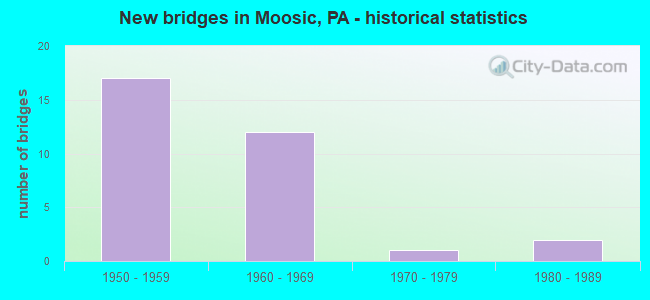
- New bridges - historical statistics
- 171950-1959
- 121960-1969
- 11970-1979
- 21980-1989

- Reconstructed bridges - Historical Statistics
- 41980-1989
- 21990-1999
- 32000-2009
- 32010-2019


- Bridge Condition - Deck
- 5.3%Very good
- 42.1%Good
- 31.6%Satisfactory
- 15.8%Fair
- 5.3%Serious

- Bridge Condition - Superstructure
- 10.5%Very good
- 21.1%Good
- 31.6%Satisfactory
- 31.6%Fair
- 5.3%Poor

- Bridge Condition - Substructure
- 21.1%Good
- 31.6%Satisfactory
- 42.1%Fair
- 5.3%Poor

- Bridge Condition - Channel
- 25.0%Very good
- 33.3%Satisfactory
- 8.3%Fair
- 33.3%Poor
Find on map >> Show street view
Structure Number: 2043, Location: Veterans Bridge (Lat: 40.443028, Lng: -79.991172), Route carried "on" structure: Interstate 579, Year Built: 1986, Year Reconstructed: 2012, Status: Open, Structure Length: 66.35m (217.68ft), Average Daily Traffic: 1,593 (year 2022), Truck Traffic: 1%, Average Future Daily Traffic: 2,161 (year 2032), Design Load: HL 93, Features Intersected: STATE RDS.,RR,CITY STS.., Facility Carried by Structure: HOV
Minimum Vertical Clearance: 6.55m (21.49ft), Kilometerpoint: 0.000, Lanes on structure: 2, Lanes under structure: 20, Base Highway Network: Yes, Owner: State Highway Agency, Approaching Roadway Width: 8.8m (28.9ft), Skew: 9 degrees, Material/Design: Steel continuous, Design/Construction: Stringer/Multi-beam, Number Of Spans In Main Unit: 15, Length of Maximum Span: 64.0m (210.0ft), Curb or Sidewalk Widths: Left: 0.2m (0.7ft), Right: 0.2m (0.7ft), Curb-To-Curb Width: 8.8m (28.9ft), Out-to-Out Width: 9.7m (31.8ft)
Condition: Deck: Good, Superstructure: Good, Substructure: Satisfactory, Operating Rating: 58.6 metric tons, Method Used To Determine Operating Rating: Assigned ratings based on Load and Resistance Factor Design (LRFD) reported by rating factor (RF) using HL93 loadings, Inventory Rating: 35.0 metric tons, Method Used To Determine Inventory Rating: Assigned ratings based on Load and Resistance Factor Design (LRFD) reported by rating factor (RF) using HL93 loadings, Structural Evaluation: Equal to present minimum criteria, Deck Geometry: Somewhat better than minimum adequacy, Underclear: High priority of replacement, Approach Roadway Alignment: Equal to present desirable criteria, Length Of Structure Improvement: 66.40m (217.85ft), Designated Inspection Frequency: Every 24 months, Critical Feature Inspection Frequency: Every 24 months, Inspection Date: April 2021, Critical Feature Inspection Date: April 2021, Bridge Improvement Cost: $1,170,000, Roadway Improvement Cost: $3,445,000, Total Project Cost: $15,792,000, Deck Structure Type: Concrete Cast-file-Place, Wearing Surface/Protective System: Wearing Surface: Monolithic Concrete, Deck Protection: Epoxy Coated Reinforcing
Find on map >> Show street view
Structure Number: 12572, Location: 3 MI W OF HETLERVILLE (Lat: 41.019533, Lng: -76.317231), Route carried "on" structure: State highway 339, Year Built: 1974, Status: Open, Structure Length: 1.01m (3.31ft), Average Daily Traffic: 1,737 (year 2022), Truck Traffic: 10%, Average Future Daily Traffic: 3,003 (year 2032), Design Load: HS 20, Features Intersected: OVER TEN MILE RUN
Minimum Vertical Clearance: 30+ m (98+ ft), Kilometerpoint: 23.363, Lanes on structure: 2, Owner: State Highway Agency, Approaching Roadway Width: 8.8m (28.9ft), Skew: 1 degrees, Material/Design: Concrete, Design/Construction: Culvert, Number Of Spans In Main Unit: 2, Length of Maximum Span: 4.9m (16.1ft)
Condition: Channel: Satisfactory, Culverts: Good, Operating Rating: 54.4 metric tons, Method Used To Determine Operating Rating: Field evaluation and documented engineering judgment, Inventory Rating: 32.7 metric tons, Method Used To Determine Inventory Rating: Field evaluation and documented engineering judgment, Structural Evaluation: Better than present minimum criteria, Waterway Adequacy: Superior to present desirable criteria, Approach Roadway Alignment: Equal to present desirable criteria, Length Of Structure Improvement: 1.00m (3.28ft), Designated Inspection Frequency: Every 24 months, Inspection Date: Febuary 2021
Find on map >> Show street view
Structure Number: 20407, Location: MOOSIC BORO .1 M S TR 502 (Lat: 41.352847, Lng: -75.731353), Route carried "on" structure: US 11, Year Built: 1959, Year Reconstructed: 1985, Status: Open, Structure Length: 2.07m (6.79ft), Average Daily Traffic: 9,887 (year 2021), Truck Traffic: 5%, Average Future Daily Traffic: 17,372 (year 2032), Design Load: HS 20, Features Intersected: SPRING BROOK
Minimum Vertical Clearance: 30+ m (98+ ft), Kilometerpoint: 0.357, Lanes on structure: 3, Base Highway Network: Yes, Owner: State Highway Agency, Approaching Roadway Width: 15.8m (51.8ft), Material/Design: Steel, Design/Construction: Stringer/Multi-beam, Number Of Spans In Main Unit: 1, Length of Maximum Span: 20.1m (65.9ft), Curb or Sidewalk Widths: Left: 1.6m (5.2ft), Right: 0.0m, Curb-To-Curb Width: 15.8m (51.8ft), Out-to-Out Width: 18.3m (60.0ft)
Condition: Deck: Satisfactory, Superstructure: Fair, Substructure: Satisfactory, Channel: Very good, Operating Rating: 46.3 metric tons, Method Used To Determine Operating Rating: Load Factor (LF), Inventory Rating: 27.2 metric tons, Method Used To Determine Inventory Rating: Load Factor (LF), Structural Evaluation: Somewhat better than minimum adequacy, Deck Geometry: Better than present minimum criteria, Waterway Adequacy: Equal to present desirable criteria, Approach Roadway Alignment: Equal to present desirable criteria, Length Of Structure Improvement: 2.10m (6.89ft), Designated Inspection Frequency: Every 24 months, Inspection Date: June 2020, Bridge Improvement Cost: $18,000, Roadway Improvement Cost: $100,000, Total Project Cost: $248,000, Deck Structure Type: Concrete Cast-file-Place, Wearing Surface/Protective System: Wearing Surface: Latex Concrete
Find on map >> Show street view
Structure Number: 20409, Location: MOOSIC BORO OVER SR 8001 (Lat: 41.359658, Lng: -75.719250), Route carried "on" structure: US 11, Year Built: 1966, Status: Open, Structure Length: 1.43m (4.69ft), Average Daily Traffic: 15,412 (year 2021), Truck Traffic: 6%, Average Future Daily Traffic: 21,716 (year 2032), Design Load: HS 20+Mod, Features Intersected: SR 8001 RAMP H
Minimum Vertical Clearance: 30+ m (98+ ft), Kilometerpoint: 1.605, Lanes on structure: 2, Lanes under structure: 1, Base Highway Network: Yes, Owner: State Highway Agency, Approaching Roadway Width: 18.6m (61.0ft), Skew: 20 degrees, Material/Design: Prestressed concrete, Design/Construction: Box Beam or Girders - Single/Spread, Number Of Spans In Main Unit: 1, Length of Maximum Span: 14.0m (45.9ft), Curb or Sidewalk Widths: Left: 0.2m (0.7ft), Right: 0.2m (0.7ft), Curb-To-Curb Width: 24.1m (79.1ft), Out-to-Out Width: 25.8m (84.6ft)
Condition: Deck: Good, Superstructure: Good, Substructure: Good, Operating Rating: 52.6 metric tons, Method Used To Determine Operating Rating: Load Factor (LF), Inventory Rating: 30.8 metric tons, Method Used To Determine Inventory Rating: Load Factor (LF), Structural Evaluation: Better than present minimum criteria, Deck Geometry: Superior to present desirable criteria, Underclear: Meets minimum limits, Approach Roadway Alignment: Equal to present desirable criteria, Length Of Structure Improvement: 1.40m (4.59ft), Designated Inspection Frequency: Every 24 months, Inspection Date: June 2020, Bridge Improvement Cost: $25,000, Roadway Improvement Cost: $100,000, Total Project Cost: $334,000, Deck Structure Type: Concrete Cast-file-Place, Wearing Surface/Protective System: Wearing Surface: Monolithic Concrete, Deck Protection: Epoxy Coated Reinforcing
Find on map >> Show street view
Structure Number: 20428, Location: MOOSIC BORO OVER TR 502 (Lat: 41.351558, Lng: -75.725308), Route carried "on" structure: Interstate 81, Year Built: 1955, Year Reconstructed: 2008, Status: Open, Structure Length: 7.28m (23.88ft), Average Daily Traffic: 23,340 (year 2020), Truck Traffic: 24%, Average Future Daily Traffic: 40,435 (year 2032), Design Load: HS 20+Mod, Features Intersected: SR 0502 TR 502
Minimum Vertical Clearance: 30+ m (98+ ft), Kilometerpoint: 0.328, Lanes on structure: 4, Lanes under structure: 2, Base Highway Network: Yes, Owner: State Highway Agency, Approaching Roadway Width: 19.2m (63.0ft), Skew: 11 degrees, Material/Design: Steel continuous, Design/Construction: Stringer/Multi-beam, Number Of Spans In Main Unit: 3, Length of Maximum Span: 29.0m (95.1ft), Curb or Sidewalk Widths: Left: 0.2m (0.7ft), Right: 0.2m (0.7ft), Curb-To-Curb Width: 19.2m (63.0ft), Out-to-Out Width: 20.2m (66.3ft)
Condition: Deck: Good, Superstructure: Satisfactory, Substructure: Good, Operating Rating: 91.6 metric tons, Method Used To Determine Operating Rating: Load Factor (LF), Inventory Rating: 54.4 metric tons, Method Used To Determine Inventory Rating: Load Factor (LF), Structural Evaluation: Equal to present minimum criteria, Deck Geometry: Somewhat better than minimum adequacy, Underclear: Equal to present minimum criteria, Approach Roadway Alignment: Equal to present desirable criteria, Length Of Structure Improvement: 7.30m (23.95ft), Designated Inspection Frequency: Every 24 months, Inspection Date: July 2021, Bridge Improvement Cost: $95,000, Roadway Improvement Cost: $280,000, Total Project Cost: $1,285,000, Deck Structure Type: Concrete Cast-file-Place, Wearing Surface/Protective System: Wearing Surface: Epoxy Overlay, Deck Protection: Epoxy Coated Reinforcing
Find on map >> Show street view
Structure Number: 2043, Location: MOOSIC BORO OVER RAMP (Lat: 41.356158, Lng: -75.721278), Route carried "on" structure: Interstate 81, Year Built: 1966, Year Reconstructed: 2019, Status: Open, Structure Length: 5.88m (19.29ft), Average Daily Traffic: 31,974 (year 2021), Truck Traffic: 18%, Average Future Daily Traffic: 42,715 (year 2032), Design Load: HS 20+Mod, Features Intersected: SR 8001 RAMP
Minimum Vertical Clearance: 30+ m (98+ ft), Kilometerpoint: 1.149, Lanes on structure: 2, Lanes under structure: 1, Base Highway Network: Yes, Owner: State Highway Agency, Approaching Roadway Width: 10.7m (35.1ft), Skew: 5 degrees, Material/Design: Prestressed concrete, Design/Construction: Stringer/Multi-beam, Number Of Spans In Main Unit: 3, Length of Maximum Span: 23.5m (77.1ft), Curb or Sidewalk Widths: Left: 0.2m (0.7ft), Right: 0.2m (0.7ft), Curb-To-Curb Width: 10.0m (32.8ft), Out-to-Out Width: 11.4m (37.4ft)
Condition: Deck: Fair, Superstructure: Fair, Substructure: Fair, Operating Rating: 80.7 metric tons, Method Used To Determine Operating Rating: Load Factor (LF), Inventory Rating: 24.5 metric tons, Method Used To Determine Inventory Rating: Load Factor (LF), Structural Evaluation: Somewhat better than minimum adequacy, Deck Geometry: High priority of replacement, Underclear: High priority of corrective action, Approach Roadway Alignment: Equal to present desirable criteria, Length Of Structure Improvement: 5.90m (19.36ft), Designated Inspection Frequency: Every 24 months, Inspection Date: June 2021, Bridge Improvement Cost: $47,000, Roadway Improvement Cost: $138,000, Total Project Cost: $635,000, Deck Structure Type: Concrete Cast-file-Place, Wearing Surface/Protective System: Wearing Surface: Latex Concrete
Find on map >> Show street view
Structure Number: 20432, Location: MOOSIC BORO OVER SR 3031 (Lat: 41.357417, Lng: -75.706958), Route carried "on" structure: Interstate 81, Year Built: 1963, Year Reconstructed: 2009, Status: Open, Structure Length: 4.72m (15.49ft), Average Daily Traffic: 30,231 (year 2021), Truck Traffic: 19%, Average Future Daily Traffic: 40,467 (year 2032), Design Load: HS 20+Mod, Features Intersected: SR 3031
Minimum Vertical Clearance: 30+ m (98+ ft), Kilometerpoint: 1.920, Lanes on structure: 2, Lanes under structure: 2, Base Highway Network: Yes, Owner: State Highway Agency, Approaching Roadway Width: 11.6m (38.1ft), Skew: 13 degrees, Material/Design: Steel continuous, Design/Construction: Stringer/Multi-beam, Number Of Spans In Main Unit: 3, Length of Maximum Span: 16.8m (55.1ft), Curb or Sidewalk Widths: Left: 0.2m (0.7ft), Right: 0.2m (0.7ft), Curb-To-Curb Width: 12.2m (40.0ft), Out-to-Out Width: 13.2m (43.3ft)
Condition: Deck: Good, Superstructure: Good, Substructure: Satisfactory, Operating Rating: 76.2 metric tons, Method Used To Determine Operating Rating: Load Factor (LF), Inventory Rating: 45.4 metric tons, Method Used To Determine Inventory Rating: Load Factor (LF), Structural Evaluation: Equal to present minimum criteria, Deck Geometry: Better than present minimum criteria, Underclear: Meets minimum limits, Approach Roadway Alignment: Equal to present desirable criteria, Length Of Structure Improvement: 4.60m (15.09ft), Designated Inspection Frequency: Every 24 months, Inspection Date: June 2021, Bridge Improvement Cost: $38,000, Roadway Improvement Cost: $111,000, Total Project Cost: $510,000, Deck Structure Type: Concrete Cast-file-Place, Wearing Surface/Protective System: Wearing Surface: Epoxy Overlay, Deck Protection: Epoxy Coated Reinforcing
Find on map >> Show street view
Structure Number: 20636, Location: MOOSIC BORO .3 M E TR 11 (Lat: 41.351611, Lng: -75.722789), Route carried "on" structure: State highway 502, Year Built: 1958, Year Reconstructed: 2010, Status: Open, Structure Length: 4.21m (13.81ft), Average Daily Traffic: 4,768 (year 2020), Truck Traffic: 5%, Average Future Daily Traffic: 7,115 (year 2032), Design Load: HS 20, Features Intersected: SPRING BROOK
Minimum Vertical Clearance: 30+ m (98+ ft), Kilometerpoint: 0.356, Lanes on structure: 2, Owner: State Highway Agency, Approaching Roadway Width: 12.2m (40.0ft), Material/Design: Prestressed concrete, Design/Construction: Box Beam or Girders - Multiple, Number Of Spans In Main Unit: 2, Length of Maximum Span: 20.1m (65.9ft), Curb or Sidewalk Widths: Left: 1.5m (4.9ft), Right: 0.5m (1.6ft), Curb-To-Curb Width: 12.4m (40.7ft), Out-to-Out Width: 15.0m (49.2ft)
Condition: Deck: Good, Superstructure: Fair, Substructure: Satisfactory, Channel: Poor, Operating Rating: 49.9 metric tons, Method Used To Determine Operating Rating: Load Factor (LF), Inventory Rating: 0.9 metric tons, Method Used To Determine Inventory Rating: Load Factor (LF), Structural Evaluation: High priority of corrective action, Deck Geometry: Equal to present minimum criteria, Waterway Adequacy: Superior to present desirable criteria, Approach Roadway Alignment: Equal to present desirable criteria, Length Of Structure Improvement: 4.10m (13.45ft), Designated Inspection Frequency: Every 24 months, Inspection Date: June 2020, Bridge Improvement Cost: $69,000, Roadway Improvement Cost: $202,000, Total Project Cost: $926,000, Wearing Surface/Protective System: Wearing Surface: Monolithic Concrete, Deck Protection: Epoxy Coated Reinforcing
Find on map >> Show street view
Structure Number: 20637, Location: MOOSIC BORO .8 M E TR 11 (Lat: 41.350942, Lng: -75.713361), Route carried "on" structure: State highway 502, Year Built: 1961, Status: Open, Structure Length: 5.49m (18.01ft), Average Daily Traffic: 4,768 (year 2020), Truck Traffic: 5%, Average Future Daily Traffic: 7,115 (year 2032), Design Load: HS 20, Features Intersected: SPRING BROOK
Minimum Vertical Clearance: 30+ m (98+ ft), Kilometerpoint: 0.863, Lanes on structure: 2, Owner: State Highway Agency, Approaching Roadway Width: 12.2m (40.0ft), Skew: 6 degrees, Material/Design: Steel continuous, Design/Construction: Stringer/Multi-beam, Number Of Spans In Main Unit: 2, Length of Maximum Span: 25.9m (85.0ft), Curb or Sidewalk Widths: Left: 1.5m (4.9ft), Right: 0.5m (1.6ft), Curb-To-Curb Width: 12.2m (40.0ft), Out-to-Out Width: 14.9m (48.9ft)
Condition: Deck: Satisfactory, Superstructure: Good, Substructure: Fair, Channel: Poor, Operating Rating: 70.8 metric tons, Method Used To Determine Operating Rating: Load Factor (LF), Inventory Rating: 42.6 metric tons, Method Used To Determine Inventory Rating: Load Factor (LF), Structural Evaluation: Somewhat better than minimum adequacy, Deck Geometry: Equal to present minimum criteria, Waterway Adequacy: Superior to present desirable criteria, Approach Roadway Alignment: Better than present minimum criteria, Length Of Structure Improvement: 6.60m (21.65ft), Designated Inspection Frequency: Every 24 months, Inspection Date: June 2020, Deck Structure Type: Concrete Cast-file-Place, Wearing Surface/Protective System: Wearing Surface: Latex Concrete
Find on map >> Show street view
Structure Number: 20788, Location: MOOSIC BORO 801' N TR 502 (Lat: 41.350931, Lng: -75.708931), Route carried "on" structure: State highway , Year Built: 1957, Status: Open, Structure Length: 0.82m (2.69ft), Average Daily Traffic: 1,450 (year 2020), Truck Traffic: 4%, Average Future Daily Traffic: 2,528 (year 2032), Design Load: HS 20, Features Intersected: BRANCH OF SPRING BROOK, Facility Carried by Structure: SR 3031
Minimum Vertical Clearance: 30+ m (98+ ft), Kilometerpoint: 0.000, Lanes on structure: 2, Owner: State Highway Agency, Approaching Roadway Width: 7.3m (24.0ft), Material/Design: Concrete, Design/Construction: Tee Beam, Number Of Spans In Main Unit: 1, Length of Maximum Span: 7.9m (25.9ft), Curb or Sidewalk Widths: Left: 0.2m (0.7ft), Right: 0.2m (0.7ft), Curb-To-Curb Width: 10.0m (32.8ft), Out-to-Out Width: 11.2m (36.7ft)
Condition: Deck: Satisfactory, Superstructure: Satisfactory, Substructure: Good, Channel: Satisfactory, Operating Rating: 52.6 metric tons, Method Used To Determine Operating Rating: Load Factor (LF), Inventory Rating: 30.8 metric tons, Method Used To Determine Inventory Rating: Load Factor (LF), Structural Evaluation: Equal to present minimum criteria, Deck Geometry: Somewhat better than minimum adequacy, Waterway Adequacy: Better than present minimum criteria, Approach Roadway Alignment: Equal to present desirable criteria, Length Of Structure Improvement: 1.40m (4.59ft), Designated Inspection Frequency: Every 24 months, Inspection Date: July 2020, Deck Structure Type: Concrete Cast-file-Place, Wearing Surface/Protective System: Wearing Surface: Bituminous
Find on map >> Show street view
Structure Number: 20937, Location: ADJACENT TO PARK STREET (Lat: 41.355681, Lng: -75.734069), Route carried "on" structure: County highway , Year Built: 1956, Year Reconstructed: 2015, Status: Open, Structure Length: 1.89m (6.20ft), Average Daily Traffic: 8,767 (year 2017), Truck Traffic: 6%, Average Future Daily Traffic: 9,106 (year 2034), Design Load: HL 93, Features Intersected: SPRING BROOK, Facility Carried by Structure: MAIN ST (SR. 3024)
Minimum Vertical Clearance: 30+ m (98+ ft), Kilometerpoint: 0.000, Lanes on structure: 2, Owner: County Highway Agency, Approaching Roadway Width: 9.1m (29.9ft), Skew: 3 degrees, Material/Design: Steel, Design/Construction: Stringer/Multi-beam, Number Of Spans In Main Unit: 1, Length of Maximum Span: 18.3m (60.0ft), Curb or Sidewalk Widths: Left: 1.4m (4.6ft), Right: 1.4m (4.6ft), Curb-To-Curb Width: 9.1m (29.9ft), Out-to-Out Width: 12.9m (42.3ft)
Condition: Deck: Very good, Superstructure: Very good, Substructure: Good, Channel: Very good, Operating Rating: 75.3 metric tons, Method Used To Determine Operating Rating: Load and Resistance Factor (LRFR), Inventory Rating: 58.1 metric tons, Method Used To Determine Inventory Rating: Load and Resistance Factor (LRFR), Structural Evaluation: Better than present minimum criteria, Deck Geometry: High priority of corrective action, Waterway Adequacy: Superior to present desirable criteria, Approach Roadway Alignment: Equal to present desirable criteria, Designated Inspection Frequency: Every 24 months, Inspection Date: September 2019, Deck Structure Type: Concrete Cast-file-Place, Wearing Surface/Protective System: Wearing Surface: Monolithic Concrete, Deck Protection: Epoxy Coated Reinforcing
Find on map >> Show street view
Structure Number: 2094, Location: MOOSIC BOROUGH (Lat: 41.345244, Lng: -75.708186), Route carried "on" structure: Interstate 476, Year Built: 1957, Year Reconstructed: 1994, Status: Open, Structure Length: 14.20m (46.59ft), Average Daily Traffic: 6,575 (year 2001), Truck Traffic: 16%, Average Future Daily Traffic: 14,039 (year 2030), Design Load: HS 20, Features Intersected: SPRING BROOK
Minimum Vertical Clearance: 30+ m (98+ ft), Kilometerpoint: 0.000, Lanes on structure: 4, Base Highway Network: Yes, Toll: On toll road, Owner: State Toll Authority, Approaching Roadway Width: 21.9m (71.9ft), Skew: 34 degrees, Material/Design: Steel continuous, Design/Construction: Stringer/Multi-beam, Number Of Spans In Main Unit: 3, Number Of Approach Spans: 1, Length of Maximum Span: 43.3m (142.1ft), Curb or Sidewalk Widths: Left: 0.2m (0.7ft), Right: 0.2m (0.7ft), Curb-To-Curb Width: 17.4m (57.1ft), Out-to-Out Width: 19.1m (62.7ft)
Condition: Deck: Good, Superstructure: Satisfactory, Substructure: Satisfactory, Channel: Satisfactory, Operating Rating: 74.4 metric tons, Method Used To Determine Operating Rating: Load Factor (LF), Inventory Rating: 44.5 metric tons, Method Used To Determine Inventory Rating: Load Factor (LF), Structural Evaluation: Equal to present minimum criteria, Deck Geometry: Meets minimum limits, Waterway Adequacy: Superior to present desirable criteria, Approach Roadway Alignment: Equal to present desirable criteria, Length Of Structure Improvement: 15.10m (49.54ft), Designated Inspection Frequency: Every 48 months, Inspection Date: July 2019, Bridge Improvement Cost: $177,000, Roadway Improvement Cost: $522,000, Total Project Cost: $2,393,000, Deck Structure Type: Concrete Cast-file-Place, Wearing Surface/Protective System: Wearing Surface: Latex Concrete
Find on map >> Show street view
Structure Number: 20941, Location: MOOSIC BOROUGH (Lat: 41.348333, Lng: -75.710000), Route carried "on" structure: Interstate 476, Year Built: 1956, Year Reconstructed: 1994, Status: Open, Structure Length: 20.45m (67.09ft), Average Daily Traffic: 6,575 (year 2001), Truck Traffic: 16%, Average Future Daily Traffic: 14,039 (year 2030), Design Load: HS 20, Features Intersected: SR 0502, Luzerne&Susq.RR
Minimum Vertical Clearance: 30+ m (98+ ft), Kilometerpoint: 0.000, Lanes on structure: 4, Lanes under structure: 2, Base Highway Network: Yes, Toll: On toll road, Owner: State Toll Authority, Approaching Roadway Width: 21.9m (71.9ft), Skew: 31 degrees, Material/Design: Steel, Design/Construction: Girder and Floorbeam System, Number Of Spans In Main Unit: 4, Number Of Approach Spans: 2, Length of Maximum Span: 57.6m (189.0ft), Curb or Sidewalk Widths: Left: 0.2m (0.7ft), Right: 0.2m (0.7ft), Curb-To-Curb Width: 16.5m (54.1ft), Out-to-Out Width: 18.9m (62.0ft)
Condition: Deck: Satisfactory, Superstructure: Fair, Substructure: Fair, Operating Rating: 42.6 metric tons, Method Used To Determine Operating Rating: Load Factor (LF), Inventory Rating: 25.4 metric tons, Method Used To Determine Inventory Rating: Load Factor (LF), Structural Evaluation: Somewhat better than minimum adequacy, Deck Geometry: Meets minimum limits, Underclear: High priority of corrective action, Approach Roadway Alignment: Equal to present desirable criteria, Length Of Structure Improvement: 21.10m (69.23ft), Designated Inspection Frequency: Every 24 months, Critical Feature Inspection Frequency: Every 24 months, Inspection Date: July 2021, Critical Feature Inspection Date: July 2021, Bridge Improvement Cost: $224,000, Roadway Improvement Cost: $660,000, Total Project Cost: $3,026,000, Deck Structure Type: Concrete Cast-file-Place, Wearing Surface/Protective System: Wearing Surface: Latex Concrete
Find on map >> Show street view
Structure Number: 20942, Location: MOOSIC BOROUGH (Lat: 41.348333, Lng: -75.710000), Route carried "on" structure: Interstate 476, Year Built: 1955, Year Reconstructed: 1994, Status: Open, Structure Length: 10.55m (34.61ft), Average Daily Traffic: 6,575 (year 2001), Truck Traffic: 16%, Average Future Daily Traffic: 14,039 (year 2030), Design Load: HS 20, Features Intersected: SM Brook & Aband. RR
Minimum Vertical Clearance: 30+ m (98+ ft), Kilometerpoint: 0.000, Lanes on structure: 4, Base Highway Network: Yes, Toll: On toll road, Owner: State Toll Authority, Approaching Roadway Width: 21.9m (71.9ft), Skew: 31 degrees, Material/Design: Steel continuous, Design/Construction: Stringer/Multi-beam, Number Of Spans In Main Unit: 3, Length of Maximum Span: 35.1m (115.2ft), Curb or Sidewalk Widths: Left: 0.2m (0.7ft), Right: 0.2m (0.7ft), Curb-To-Curb Width: 8.7m (28.5ft), Out-to-Out Width: 18.9m (62.0ft)
Condition: Deck: Good, Superstructure: Satisfactory, Substructure: Fair, Channel: Very good, Operating Rating: 89.8 metric tons, Method Used To Determine Operating Rating: Load Factor (LF), Inventory Rating: 54.4 metric tons, Method Used To Determine Inventory Rating: Load Factor (LF), Structural Evaluation: Somewhat better than minimum adequacy, Deck Geometry: High priority of replacement, Underclear: High priority of corrective action, Waterway Adequacy: Superior to present desirable criteria, Approach Roadway Alignment: Equal to present desirable criteria, Length Of Structure Improvement: 11.60m (38.06ft), Designated Inspection Frequency: Every 24 months, Inspection Date: July 2021, Bridge Improvement Cost: $103,000, Roadway Improvement Cost: $303,000, Total Project Cost: $1,388,000, Deck Structure Type: Concrete Cast-file-Place, Wearing Surface/Protective System: Wearing Surface: Latex Concrete
Find on map >> Show street view
Structure Number: 20943, Location: MOOSIC BOROUGH (Lat: 41.361964, Lng: -75.718683), Route carried "on" structure: Interstate 476, Year Built: 1955, Year Reconstructed: 1999, Status: Open, Structure Length: 3.69m (12.11ft), Average Daily Traffic: 6,575 (year 2001), Truck Traffic: 16%, Average Future Daily Traffic: 9,293 (year 2030), Design Load: HS 20, Features Intersected: SR 0011, LR 5
Minimum Vertical Clearance: 30+ m (98+ ft), Kilometerpoint: 0.000, Lanes on structure: 4, Lanes under structure: 6, Base Highway Network: Yes, Toll: On toll road, Owner: State Toll Authority, Approaching Roadway Width: 21.3m (69.9ft), Skew: 34 degrees, Material/Design: Steel, Design/Construction: Stringer/Multi-beam, Number Of Spans In Main Unit: 1, Length of Maximum Span: 34.7m (113.8ft), Curb or Sidewalk Widths: Left: 0.5m (1.6ft), Right: 0.5m (1.6ft), Curb-To-Curb Width: 16.5m (54.1ft), Out-to-Out Width: 19.5m (64.0ft)
Condition: Deck: Fair, Superstructure: Satisfactory, Substructure: Satisfactory, Operating Rating: 84.4 metric tons, Method Used To Determine Operating Rating: Load Factor (LF), Inventory Rating: 50.8 metric tons, Method Used To Determine Inventory Rating: Load Factor (LF), Structural Evaluation: Equal to present minimum criteria, Deck Geometry: High priority of replacement, Underclear: Meets minimum limits, Approach Roadway Alignment: Equal to present desirable criteria, Length Of Structure Improvement: 4.70m (15.42ft), Designated Inspection Frequency: Every 24 months, Inspection Date: June 2021, Bridge Improvement Cost: $41,000, Roadway Improvement Cost: $121,000, Total Project Cost: $554,000, Deck Structure Type: Concrete Cast-file-Place, Wearing Surface/Protective System: Wearing Surface: Latex Concrete
Find on map >> Show street view
Structure Number: 20944, Location: MOOSIC BOROUGH (Lat: 41.377375, Lng: -75.720533), Route carried "on" structure: Interstate 476, Year Built: 1955, Year Reconstructed: 1995, Status: Open, Structure Length: 22.86m (75.00ft), Average Daily Traffic: 6,576 (year 2001), Truck Traffic: 16%, Average Future Daily Traffic: 14,041 (year 2030), Design Load: HS 20, Features Intersected: LACKA. RV, NS & RBMN RR
Minimum Vertical Clearance: 30+ m (98+ ft), Kilometerpoint: 0.000, Lanes on structure: 4, Base Highway Network: Yes, Toll: On toll road, Owner: State Toll Authority, Approaching Roadway Width: 21.9m (71.9ft), Skew: 35 degrees, Material/Design: Steel continuous, Design/Construction: Girder and Floorbeam System, Number Of Spans In Main Unit: 5, Length of Maximum Span: 51.8m (169.9ft), Curb or Sidewalk Widths: Left: 0.2m (0.7ft), Right: 0.2m (0.7ft), Curb-To-Curb Width: 16.9m (55.4ft), Out-to-Out Width: 18.6m (61.0ft)
Condition: Deck: Satisfactory, Superstructure: Fair, Substructure: Fair, Channel: Satisfactory, Operating Rating: 86.2 metric tons, Method Used To Determine Operating Rating: Load Factor (LF), Inventory Rating: 51.7 metric tons, Method Used To Determine Inventory Rating: Load Factor (LF), Structural Evaluation: Somewhat better than minimum adequacy, Deck Geometry: Meets minimum limits, Underclear: High priority of corrective action, Waterway Adequacy: Superior to present desirable criteria, Approach Roadway Alignment: Equal to present desirable criteria, Length Of Structure Improvement: 23.40m (76.77ft), Designated Inspection Frequency: Every 24 months, Critical Feature Inspection Frequency: Every 24 months, Underwater Inspection Frequency: Every 60 months, Inspection Date: July 2021, Critical Feature Inspection Date: July 2021, Underwater Inspection Date: October 2018, Bridge Improvement Cost: $340,000, Roadway Improvement Cost: $1,002,000, Total Project Cost: $4,593,000, Deck Structure Type: Concrete Cast-file-Place, Wearing Surface/Protective System: Wearing Surface: Latex Concrete, Deck Protection: Epoxy Coated Reinforcing
Find on map >> Show street view
Structure Number: 20962, Location: MOOSIC BORO OVER TR 11 NB (Lat: 41.355825, Lng: -75.722572), Route carried "on" structure: Ramp State highway , Year Built: 1955, Status: Open, Structure Length: 5.49m (18.01ft), Average Daily Traffic: 2,370 (year 2021), Truck Traffic: 7%, Average Future Daily Traffic: 2,658 (year 2032), Design Load: H 20, Features Intersected: SR 0011 TR 11 NB, Facility Carried by Structure: SR 8001
Minimum Vertical Clearance: 30+ m (98+ ft), Kilometerpoint: 0.000, Lanes on structure: 2, Lanes under structure: 2, Base Highway Network: Yes, Owner: State Highway Agency, Approaching Roadway Width: 11.0m (36.1ft), Skew: 5 degrees, Material/Design: Steel continuous, Design/Construction: Stringer/Multi-beam, Number Of Spans In Main Unit: 3, Length of Maximum Span: 21.9m (71.9ft), Curb or Sidewalk Widths: Left: 0.5m (1.6ft), Right: 0.5m (1.6ft), Curb-To-Curb Width: 9.8m (32.2ft), Out-to-Out Width: 11.4m (37.4ft)
Condition: Deck: Serious, Superstructure: Poor, Substructure: Poor, Operating Rating: 51.7 metric tons, Method Used To Determine Operating Rating: Load Factor (LF), Inventory Rating: 30.8 metric tons, Method Used To Determine Inventory Rating: Load Factor (LF), Structural Evaluation: Meets minimum limits, Deck Geometry: Equal to present minimum criteria, Underclear: High priority of corrective action, Approach Roadway Alignment: Equal to present desirable criteria, Length Of Structure Improvement: 5.50m (18.04ft), Designated Inspection Frequency: Every 24 months, Other Special Inspection Frequency: Every 6 months, Inspection Date: June 2021, Other Special Inspection Date: June 2021, Bridge Improvement Cost: $28,000, Roadway Improvement Cost: $100,000, Total Project Cost: $379,000, Deck Structure Type: Concrete Cast-file-Place, Wearing Surface/Protective System: Wearing Surface: Bituminous
Find on map >> Show street view
Structure Number: 23946, Location: PITTSTN TWP 600'E CO LINE (Lat: 41.340408, Lng: -75.705236), Route carried "on" structure: State highway 502, Year Built: 1957, Status: Open, Structure Length: 4.75m (15.58ft), Average Daily Traffic: 3,940 (year 2021), Truck Traffic: 9%, Average Future Daily Traffic: 5,034 (year 2032), Design Load: H 20, Features Intersected: SPRING BROOK
Minimum Vertical Clearance: 30+ m (98+ ft), Kilometerpoint: 0.000, Lanes on structure: 2, Owner: State Highway Agency, Approaching Roadway Width: 11.9m (39.0ft), Skew: 3 degrees, Material/Design: Steel, Design/Construction: Stringer/Multi-beam, Number Of Spans In Main Unit: 2, Length of Maximum Span: 22.6m (74.1ft), Curb-To-Curb Width: 12.2m (40.0ft), Out-to-Out Width: 12.8m (42.0ft)
Condition: Deck: Fair, Superstructure: Fair, Substructure: Fair, Channel: Poor, Operating Rating: 64.4 metric tons, Method Used To Determine Operating Rating: Load Factor (LF), Inventory Rating: 38.1 metric tons, Method Used To Determine Inventory Rating: Load Factor (LF), Structural Evaluation: Somewhat better than minimum adequacy, Deck Geometry: Equal to present minimum criteria, Waterway Adequacy: Equal to present desirable criteria, Approach Roadway Alignment: Better than present minimum criteria, Length Of Structure Improvement: 4.79m (15.72ft), Designated Inspection Frequency: Every 24 months, Inspection Date: September 2020, Bridge Improvement Cost: $68,000, Roadway Improvement Cost: $200,000, Total Project Cost: $917,000, Deck Structure Type: Concrete Cast-file-Place, Wearing Surface/Protective System: Wearing Surface: Latex Concrete
Find on map >> Show street view
Structure Number: 23947, Location: PITTSTON TWP 2M E SR 3031 (Lat: 41.327717, Lng: -75.689761), Route carried "on" structure: State highway 502, Year Built: 1987, Status: Open, Structure Length: 0.85m (2.79ft), Average Daily Traffic: 2,207 (year 2021), Truck Traffic: 14%, Average Future Daily Traffic: 2,988 (year 2032), Design Load: HS 20, Features Intersected: TROUT CREEK
Minimum Vertical Clearance: 30+ m (98+ ft), Kilometerpoint: 1.635, Lanes on structure: 2, Owner: State Highway Agency, Approaching Roadway Width: 10.4m (34.1ft), Skew: 1 degrees, Material/Design: Prestressed concrete, Design/Construction: Box Beam or Girders - Multiple, Number Of Spans In Main Unit: 1, Length of Maximum Span: 8.2m (26.9ft), Curb or Sidewalk Widths: Left: 0.2m (0.7ft), Right: 0.2m (0.7ft), Curb-To-Curb Width: 12.8m (42.0ft), Out-to-Out Width: 13.6m (44.6ft)
Condition: Deck: Good, Superstructure: Very good, Substructure: Fair, Channel: Fair, Inventory Rating: 68.0 metric tons, Method Used To Determine Inventory Rating: Load Factor (LF), Structural Evaluation: Somewhat better than minimum adequacy, Deck Geometry: Equal to present minimum criteria, Waterway Adequacy: Superior to present desirable criteria, Approach Roadway Alignment: Better than present minimum criteria, Length Of Structure Improvement: 1.50m (4.92ft), Designated Inspection Frequency: Every 24 months, Inspection Date: August 2020, Bridge Improvement Cost: $9,000, Roadway Improvement Cost: $27,000, Total Project Cost: $123,000, Deck Structure Type: Concrete Cast-file-Place, Wearing Surface/Protective System: Wearing Surface: Monolithic Concrete, Deck Protection: Epoxy Coated Reinforcing
Find on map >> Show street view
Structure Number: 55901, Location: .24M S SR 502 (Lat: 41.325183, Lng: -75.688264), Route carried "on" structure: City street , Year Built: 1960, Status: Open, Structure Length: 1.92m (6.30ft), Average Daily Traffic: 150 (year 2018), Truck Traffic: 2%, Average Future Daily Traffic: 150 (year 2035), Design Load: HS 20, Features Intersected: MONUMENT CREEK, Facility Carried by Structure: ASTON MTN. RD.
Minimum Vertical Clearance: 30+ m (98+ ft), Kilometerpoint: 0.000, Lanes on structure: 2, Owner: Town or Township Highway Agency, Approaching Roadway Width: 5.8m (19.0ft), Skew: 3 degrees, Material/Design: Prestressed concrete, Design/Construction: Box Beam or Girders - Multiple, Number Of Spans In Main Unit: 1, Length of Maximum Span: 18.6m (61.0ft), Curb or Sidewalk Widths: Left: 0.2m (0.7ft), Right: 0.2m (0.7ft), Curb-To-Curb Width: 7.0m (23.0ft), Out-to-Out Width: 7.5m (24.6ft)
Condition: Deck: Satisfactory, Superstructure: Satisfactory, Substructure: Fair, Channel: Poor, Operating Rating: 32.7 metric tons, Method Used To Determine Operating Rating: Field evaluation and documented engineering judgment, Inventory Rating: 19.1 metric tons, Method Used To Determine Inventory Rating: Field evaluation and documented engineering judgment, Structural Evaluation: Somewhat better than minimum adequacy, Deck Geometry: Meets minimum limits, Waterway Adequacy: Better than present minimum criteria, Approach Roadway Alignment: Equal to present desirable criteria, Designated Inspection Frequency: Every 24 months, Inspection Date: October 2020, Deck Structure Type: Other, Wearing Surface/Protective System: Wearing Surface: Bituminous
Find on map >> Show street view
Structure Number: 20409, Location: MOOSIC BORO OVER SR 8001 (Lat: 41.359658, Lng: -75.719250), Route carried "under" structure: Ramp State highway , Year Built: 1966, Structure Length: 0. m, Average Daily Traffic: 3,731 (year 2021), Truck Traffic: 7%, Features Intersected: SR 8001 RAMP H, Facility Carried by Structure: TR 11 BIRNEY AVE
Minimum Vertical Clearance: 4.60m (15.09ft), Kilometerpoint: 0.000, Lanes on structure: 2, Lanes under structure: 1, Material/Design: Prestressed concrete, Design/Construction: Box Beam or Girders - Single/Spread, Length of Maximum Span: 14.0m (45.9ft)
Find on map >> Show street view
Structure Number: 20425, Location: MOOSIC BORO OVER TR 502 (Lat: 41.351517, Lng: -75.724789), Route carried "under" structure: State highway 502, Year Built: 1966, Structure Length: 0. m, Average Daily Traffic: 4,768 (year 2020), Truck Traffic: 5%, Features Intersected: SR 0502 TR 502, Facility Carried by Structure: SR 0081 I-81 NB
Minimum Vertical Clearance: 16.12m (52.89ft), Kilometerpoint: 0.356, Lanes on structure: 2, Lanes under structure: 2, Material/Design: Prestressed concrete, Design/Construction: Stringer/Multi-beam, Length of Maximum Span: 31.7m (104.0ft)
Find on map >> Show street view
Structure Number: 20428, Location: MOOSIC BORO OVER TR 502 (Lat: 41.351558, Lng: -75.725308), Route carried "under" structure: State highway 502, Year Built: 1955, Structure Length: 0. m, Average Daily Traffic: 4,768 (year 2020), Truck Traffic: 5%, Features Intersected: SR 0502 TR 502, Facility Carried by Structure: SR 0081 I-81 SB
Minimum Vertical Clearance: 13.32m (43.70ft), Kilometerpoint: 0.000, Lanes on structure: 4, Lanes under structure: 2, Material/Design: Steel continuous, Design/Construction: Stringer/Multi-beam, Length of Maximum Span: 29.0m (95.1ft)
Find on map >> Show street view
Structure Number: 20429, Location: MOOSIC BO OVR PA TURNPIKE (Lat: 41.355733, Lng: -75.715050), Route carried "under" structure: Spur Other road 476, Year Built: 1966, Structure Length: 0. m, Average Daily Traffic: 30,409 (year 1984), Truck Traffic: 10%, Features Intersected: I-476 PA TURNPIKE, Facility Carried by Structure: SR 0081 I-81 NB
Minimum Vertical Clearance: 4.67m (15.32ft), Kilometerpoint: 0.000, Lanes on structure: 2, Lanes under structure: 4, Material/Design: Prestressed concrete, Design/Construction: Box Beam or Girders - Multiple, Length of Maximum Span: 25.9m (85.0ft)
Find on map >> Show street view
Structure Number: 2043, Location: MOOSIC BORO OVER RAMP (Lat: 41.356158, Lng: -75.721278), Route carried "under" structure: Ramp State highway , Year Built: 1966, Structure Length: 0. m, Average Daily Traffic: 4,792 (year 2021), Truck Traffic: 7%, Features Intersected: SR 8001 RAMP, Facility Carried by Structure: SR 0081 I-81 SB
Minimum Vertical Clearance: 4.78m (15.68ft), Kilometerpoint: 0.000, Lanes on structure: 2, Lanes under structure: 1, Material/Design: Prestressed concrete, Design/Construction: Stringer/Multi-beam, Length of Maximum Span: 23.5m (77.1ft)
Find on map >> Show street view
Structure Number: 20431, Location: MOOSIC BORO OVER TURNPIKE (Lat: 41.357289, Lng: -75.716250), Route carried "under" structure: Spur Other road 476, Year Built: 1966, Structure Length: 0. m, Average Daily Traffic: 200 (year 1992), Truck Traffic: 1%, Features Intersected: I-476 PA TURNPIKE, Facility Carried by Structure: SR 0081 I-81 SB
Minimum Vertical Clearance: 5.00m (16.40ft), Kilometerpoint: 0.000, Lanes on structure: 2, Lanes under structure: 4, Material/Design: Prestressed concrete, Design/Construction: Box Beam or Girders - Multiple, Length of Maximum Span: 26.8m (87.9ft)
Find on map >> Show street view
Structure Number: 20432, Location: MOOSIC BORO OVER SR 3031 (Lat: 41.357417, Lng: -75.706958), Route carried "under" structure: State highway , Year Built: 1963, Structure Length: 0. m, Average Daily Traffic: 1,450 (year 2020), Truck Traffic: 4%, Features Intersected: SR 3031, Facility Carried by Structure: SR 0081 I-81 NB
Minimum Vertical Clearance: 5.58m (18.31ft), Kilometerpoint: 1.001, Lanes on structure: 2, Lanes under structure: 2, Material/Design: Steel continuous, Design/Construction: Stringer/Multi-beam, Length of Maximum Span: 16.8m (55.1ft)
Find on map >> Show street view
Structure Number: 20433, Location: MOOSIC BORO OVER SR 3031 (Lat: 41.358444, Lng: -75.706789), Route carried "under" structure: State highway , Year Built: 1963, Structure Length: 0. m, Average Daily Traffic: 1,450 (year 2020), Truck Traffic: 4%, Features Intersected: SR 3031, Facility Carried by Structure: SR 0081 I-81 SB
Minimum Vertical Clearance: 4.42m (14.50ft), Kilometerpoint: 1.001, Lanes on structure: 2, Lanes under structure: 2, Material/Design: Steel continuous, Design/Construction: Stringer/Multi-beam, Length of Maximum Span: 14.9m (48.9ft)
Find on map >> Show street view
Structure Number: 20941, Location: MOOSIC BOROUGH (Lat: 41.348333, Lng: -75.710000), Route carried "under" structure: State highway 502, Year Built: 1956, Structure Length: 0. m, Average Daily Traffic: 4,768 (year 2020), Truck Traffic: 5%, Features Intersected: SR 0502, Luzerne&Susq.RR, Facility Carried by Structure: PA TPK (I-476)
Minimum Vertical Clearance: 10.82m (35.50ft), Kilometerpoint: 0.863, Lanes on structure: 4, Lanes under structure: 2, Material/Design: Steel, Design/Construction: Girder and Floorbeam System, Length of Maximum Span: 57.6m (189.0ft)
Find on map >> Show street view
Structure Number: 20943, Location: MOOSIC BOROUGH (Lat: 41.361964, Lng: -75.718683), Route carried "under" structure: US 11, Year Built: 1955, Structure Length: 0. m, Average Daily Traffic: 7,055 (year 2021), Truck Traffic: 5%, Features Intersected: SR 0011, LR 5, Facility Carried by Structure: PA TPK (I-476)
Minimum Vertical Clearance: 4.33m (14.21ft), Kilometerpoint: 2.371, Lanes on structure: 4, Lanes under structure: 2, Material/Design: Steel, Design/Construction: Stringer/Multi-beam, Length of Maximum Span: 34.7m (113.8ft)
Find on map >> Show street view
Structure Number: 20943, Location: MOOSIC BOROUGH (Lat: 41.361964, Lng: -75.718683), Route carried "under" structure: US 11, Year Built: 1955, Structure Length: 0. m, Average Daily Traffic: 8,357 (year 2021), Truck Traffic: 6%, Features Intersected: SR 0011, LR 5, Facility Carried by Structure: PA TPK (I-476)
Minimum Vertical Clearance: 4.42m (14.50ft), Kilometerpoint: 2.393, Lanes on structure: 4, Lanes under structure: 4, Material/Design: Steel, Design/Construction: Stringer/Multi-beam, Length of Maximum Span: 34.7m (113.8ft)
Find on map >> Show street view
Structure Number: 20962, Location: MOOSIC BORO OVER TR 11 NB (Lat: 41.355825, Lng: -75.722572), Route carried "under" structure: US 11, Year Built: 1955, Structure Length: 0. m, Average Daily Traffic: 8,357 (year 2021), Truck Traffic: 6%, Features Intersected: SR 0011 TR 11 NB, Facility Carried by Structure: SR 8001
Minimum Vertical Clearance: 4.65m (15.26ft), Kilometerpoint: 1.605, Lanes on structure: 2, Lanes under structure: 2, Material/Design: Steel continuous, Design/Construction: Stringer/Multi-beam, Length of Maximum Span: 21.9m (71.9ft)