Bridge Statistics for Moore Haven, Florida (FL)
Condition, Traffic, Stress, Structural Evaluation, Project Costs
- National Bridge Inventory (NBI) Statistics
- 12Number of bridges
- 279ft / 84.8mTotal length
- 52,291Total average daily traffic
- 14,360Total average daily truck traffic
- National Bridge Inventory (NBI) Registered Bridges for Moore Haven
- No street view available for this location
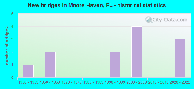
- New bridges - historical statistics
- 11950-1959
- 21960-1969
- 21990-1999
- 42000-2009
- 32020-2022

- Reconstructed bridges - Historical Statistics
- 11970-1979
- 11980-1989


- Bridge Condition - Deck
- 50.0%Very good
- 50.0%Good

- Bridge Condition - Superstructure
- 50.0%Very good
- 50.0%Good

- Bridge Condition - Substructure
- 50.0%Very good
- 50.0%Good

- Bridge Condition - Channel
- 22.2%Very good
- 66.7%Good
- 11.1%Satisfactory

- Bridge Condition - Culverts
- 66.7%Good
- 33.3%Satisfactory
Find on map >> Show street view
Structure Number: 50028, Location: 3MI S OF JCT US27/SR78 (Lat: 26.833889, Lng: -81.139167), Route carried "on" structure: US 27, Year Built: 1959, Year Reconstructed: 1987, Status: Open, Structure Length: 0.67m (2.20ft), Average Daily Traffic: 7,900 (year 2020), Truck Traffic: 36%, Average Future Daily Traffic: 13,706 (year 2042), Design Load: H 15, Features Intersected: NEWHALL FLOOD CANAL
Minimum Vertical Clearance: 30+ m (98+ ft), Kilometerpoint: 12.508, Lanes on structure: 4, Base Highway Network: Yes, Owner: State Highway Agency, Approaching Roadway Width: 17.1m (56.1ft), Skew: 10 degrees, Material/Design: Concrete, Design/Construction: Culvert, Number Of Spans In Main Unit: 2, Length of Maximum Span: 3.3m (10.8ft)
Condition: Channel: Good, Culverts: Satisfactory, Operating Rating: 76.8 metric tons, Method Used To Determine Operating Rating: Load Factor (LF), Inventory Rating: 46.1 metric tons, Method Used To Determine Inventory Rating: Load Factor (LF), Structural Evaluation: Equal to present minimum criteria, Waterway Adequacy: Equal to present desirable criteria, Approach Roadway Alignment: Equal to present desirable criteria, Designated Inspection Frequency: Every 24 months, Underwater Inspection Frequency: Every 24 months, Inspection Date: Febuary 2020, Underwater Inspection Date: January 2020
Find on map >> Show street view
Structure Number: 50063, Location: 2.7MI N OF SR-80 (Lat: 26.793811, Lng: -81.082581), Route carried "on" structure: US 27, Year Built: 1961, Year Reconstructed: 1984, Status: Open, Structure Length: 0.67m (2.20ft), Average Daily Traffic: 11,600 (year 2020), Truck Traffic: 36%, Average Future Daily Traffic: 20,126 (year 2042), Design Load: HS 20+Mod, Features Intersected: SHARP BEND CANAL
Minimum Vertical Clearance: 30+ m (98+ ft), Kilometerpoint: 2.816, Lanes on structure: 4, Base Highway Network: Yes, Owner: State Highway Agency, Approaching Roadway Width: 17.1m (56.1ft), Skew: 20 degrees, Material/Design: Concrete, Design/Construction: Culvert, Number Of Spans In Main Unit: 2, Length of Maximum Span: 3.3m (10.8ft)
Condition: Channel: Good, Culverts: Good, Inventory Rating: 64.6 metric tons, Method Used To Determine Inventory Rating: Load Factor (LF), Structural Evaluation: Better than present minimum criteria, Waterway Adequacy: Equal to present desirable criteria, Approach Roadway Alignment: Equal to present desirable criteria, Designated Inspection Frequency: Every 24 months, Underwater Inspection Frequency: Every 24 months, Inspection Date: Febuary 2020, Underwater Inspection Date: January 2020
Find on map >> Show street view
Structure Number: 50064, Location: 900FT EAST OF FIRST ST (Lat: 26.833069, Lng: -81.088731), Route carried "on" structure: US 27, Year Built: 2000, Status: Open, Structure Length: 69.52m (228.08ft), Average Daily Traffic: 11,600 (year 2020), Truck Traffic: 36%, Average Future Daily Traffic: 20,126 (year 2042), Design Load: HS 20+Mod, Features Intersected: CALOOSAHATCHEE RIVER
Minimum Vertical Clearance: 30+ m (98+ ft), Kilometerpoint: 7.137, Lanes on structure: 4, Lanes under structure: 6, Base Highway Network: Yes, Owner: State Highway Agency, Approaching Roadway Width: 21.2m (69.6ft), Skew: 30 degrees, Navigation Control: Yes ( Vertical Clearance: 17.3m (56.8ft), Horizontal Clearance: 68.8m (225.7ft)), Material/Design: Prestressed concrete continuous, Design/Construction: Stringer/Multi-beam, Number Of Spans In Main Unit: 3, Number Of Approach Spans: 12, Length of Maximum Span: 97.7m (320.5ft), Curb or Sidewalk Widths: Left: 1.6m (5.2ft), Right: 1.6m (5.2ft), Curb-To-Curb Width: 26.4m (86.6ft), Out-to-Out Width: 32.0m (105.0ft)
Condition: Deck: Good, Superstructure: Good, Substructure: Very good, Channel: Very good, Inventory Rating: 60.8 metric tons, Method Used To Determine Inventory Rating: Load Factor (LF), Structural Evaluation: Better than present minimum criteria, Deck Geometry: Superior to present desirable criteria, Underclear: Superior to present desirable criteria, Waterway Adequacy: Equal to present desirable criteria, Approach Roadway Alignment: Equal to present desirable criteria, Designated Inspection Frequency: Every 24 months, Inspection Date: Febuary 2022, Deck Structure Type: Concrete Cast-file-Place
Find on map >> Show street view
Structure Number: 50065, Location: 3.5MI EAST OF US-27 (Lat: 26.885275, Lng: -81.122550), Route carried "on" structure: State highway 78, Year Built: 1995, Status: Open, Structure Length: 3.51m (11.52ft), Average Daily Traffic: 3,866 (year 2020), Truck Traffic: 30%, Average Future Daily Traffic: 6,708 (year 2042), Design Load: HS 20+Mod, Features Intersected: L-41 CANAL
Minimum Vertical Clearance: 30+ m (98+ ft), Kilometerpoint: 5.689, Lanes on structure: 2, Base Highway Network: Yes, Owner: State Highway Agency, Approaching Roadway Width: 13.4m (44.0ft), Material/Design: Concrete continuous, Design/Construction: Slab, Number Of Spans In Main Unit: 3, Length of Maximum Span: 11.7m (38.4ft), Curb-To-Curb Width: 13.4m (44.0ft), Out-to-Out Width: 14.3m (46.9ft)
Condition: Deck: Good, Superstructure: Good, Substructure: Good, Channel: Good, Operating Rating: 44.3 metric tons, Method Used To Determine Operating Rating: Load and Resistance Factor (LRFR), Inventory Rating: 34.1 metric tons, Method Used To Determine Inventory Rating: Load and Resistance Factor (LRFR), Structural Evaluation: Better than present minimum criteria, Deck Geometry: Better than present minimum criteria, Waterway Adequacy: Equal to present desirable criteria, Approach Roadway Alignment: Equal to present desirable criteria, Designated Inspection Frequency: Every 24 months, Underwater Inspection Frequency: Every 24 months, Inspection Date: Febuary 2020, Underwater Inspection Date: January 2020, Deck Structure Type: Concrete Cast-file-Place
Find on map >> Show street view
Structure Number: 54008, Location: E SIDE MOORE HAVEN LOCKS (Lat: 26.841028, Lng: -81.089278), Route carried "on" structure: County highway 720, Year Built: 1965, Status: Open, Structure Length: 0.66m (2.17ft), Average Daily Traffic: 110 (year 2021), Truck Traffic: 1%, Average Future Daily Traffic: 155 (year 2041), Features Intersected: BILLS CANAL
Minimum Vertical Clearance: 30+ m (98+ ft), Kilometerpoint: 0.000, Lanes on structure: 2, Owner: County Highway Agency, Approaching Roadway Width: 6.4m (21.0ft), Material/Design: Concrete, Design/Construction: Culvert, Number Of Spans In Main Unit: 2, Length of Maximum Span: 3.3m (10.8ft)
Condition: Channel: Good, Culverts: Good, Inventory Rating: 84.5 metric tons, Method Used To Determine Inventory Rating: Load Factor (LF), Structural Evaluation: Better than present minimum criteria, Waterway Adequacy: Equal to present desirable criteria, Approach Roadway Alignment: Equal to present minimum criteria, Designated Inspection Frequency: Every 24 months, Underwater Inspection Frequency: Every 24 months, Inspection Date: September 2021, Underwater Inspection Date: August 2021
Find on map >> Show street view
Structure Number: 54018, Location: 1.3MI WEST OF US 27 (Lat: 26.817300, Lng: -81.102369), Route carried "on" structure: County highway , Year Built: 1994, Status: Posted for load-capacity, Structure Length: 0.79m (2.59ft), Average Daily Traffic: 95 (year 2021), Truck Traffic: 1%, Average Future Daily Traffic: 114 (year 2041), Features Intersected: TIFFS CREEK, Facility Carried by Structure: RIVER ROAD
Minimum Vertical Clearance: 30+ m (98+ ft), Kilometerpoint: 0.000, Lanes on structure: 2, Owner: County Highway Agency, Approaching Roadway Width: 6.2m (20.3ft), Material/Design: Wood or Timber, Design/Construction: Slab, Number Of Spans In Main Unit: 1, Length of Maximum Span: 7.9m (25.9ft), Curb or Sidewalk Widths: Left: 0.2m (0.7ft), Right: 0.2m (0.7ft), Curb-To-Curb Width: 6.2m (20.3ft), Out-to-Out Width: 6.6m (21.7ft)
Condition: Deck: Good, Superstructure: Good, Substructure: Good, Channel: Satisfactory, Operating Rating: 48.4 metric tons, Method Used To Determine Operating Rating: Allowable Stress (AS), Inventory Rating: 33.3 metric tons, Method Used To Determine Inventory Rating: Allowable Stress (AS), Structural Evaluation: Better than present minimum criteria, Deck Geometry: Somewhat better than minimum adequacy, Waterway Adequacy: Superior to present desirable criteria, Approach Roadway Alignment: Equal to present desirable criteria, Designated Inspection Frequency: Every 24 months, Inspection Date: September 2021, Wearing Surface/Protective System: Wearing Surface: Bituminous
Find on map >> Show street view
Structure Number: 70083, Location: 8.0MI W/O US-27 (Lat: 26.768333, Lng: -81.205556), Route carried "on" structure: State highway 70, Year Built: 2020, Status: Open, Structure Length: 2.74m (8.99ft), Average Daily Traffic: 5,550 (year 2020), Truck Traffic: 12%, Average Future Daily Traffic: 9,629 (year 2042), Design Load: HL 93, Features Intersected: MYRTLE SLOUGH CANAL, Facility Carried by Structure: SR-80 EB
Minimum Vertical Clearance: 30+ m (98+ ft), Kilometerpoint: 38.315, Lanes on structure: 3, Base Highway Network: Yes, Owner: State Highway Agency, Approaching Roadway Width: 15.8m (51.8ft), Material/Design: Concrete continuous, Design/Construction: Slab, Number Of Spans In Main Unit: 3, Length of Maximum Span: 9.1m (29.9ft), Curb-To-Curb Width: 15.8m (51.8ft), Out-to-Out Width: 16.8m (55.1ft)
Condition: Deck: Very good, Superstructure: Very good, Substructure: Very good, Channel: Good, Operating Rating: 53.9 metric tons, Method Used To Determine Operating Rating: Load and Resistance Factor (LRFR), Inventory Rating: 41.5 metric tons, Method Used To Determine Inventory Rating: Load and Resistance Factor (LRFR), Structural Evaluation: Equal to present desirable criteria, Deck Geometry: Better than present minimum criteria, Waterway Adequacy: Equal to present desirable criteria, Approach Roadway Alignment: Equal to present desirable criteria, Designated Inspection Frequency: Every 24 months, Underwater Inspection Frequency: Every 23 months, Inspection Date: March 2020, Underwater Inspection Date: March 2020, Deck Structure Type: Concrete Cast-file-Place
Find on map >> Show street view
Structure Number: 70085, Location: 5.9MI W/O US-27 (Lat: 26.767339, Lng: -81.171850), Route carried "on" structure: State highway 80, Year Built: 2020, Status: Open, Structure Length: 3.69m (12.11ft), Average Daily Traffic: 5,550 (year 2020), Truck Traffic: 12%, Average Future Daily Traffic: 9,629 (year 2042), Design Load: HL 93, Features Intersected: HILLARD CANAL
Minimum Vertical Clearance: 30+ m (98+ ft), Kilometerpoint: 41.711, Lanes on structure: 2, Base Highway Network: Yes, Owner: State Highway Agency, Approaching Roadway Width: 12.4m (40.7ft), Skew: 3 degrees, Material/Design: Concrete continuous, Design/Construction: Slab, Number Of Spans In Main Unit: 4, Length of Maximum Span: 9.1m (29.9ft), Curb-To-Curb Width: 12.4m (40.7ft), Out-to-Out Width: 13.1m (43.0ft)
Condition: Deck: Very good, Superstructure: Very good, Substructure: Good, Channel: Good, Operating Rating: 63.3 metric tons, Method Used To Determine Operating Rating: Load and Resistance Factor (LRFR), Inventory Rating: 49.0 metric tons, Method Used To Determine Inventory Rating: Load and Resistance Factor (LRFR), Structural Evaluation: Better than present minimum criteria, Deck Geometry: Better than present minimum criteria, Waterway Adequacy: Equal to present desirable criteria, Approach Roadway Alignment: Equal to present desirable criteria, Designated Inspection Frequency: Every 24 months, Underwater Inspection Frequency: Every 23 months, Inspection Date: March 2020, Underwater Inspection Date: March 2020, Deck Structure Type: Concrete Cast-file-Place, Wearing Surface/Protective System: Wearing Surface: Monolithic Concrete
Find on map >> Show street view
Structure Number: 70086, Location: 8.3MI E/O SR-29 (Lat: 26.768611, Lng: -81.304167), Route carried "on" structure: US 80, Year Built: 2020, Status: Open, Structure Length: 2.56m (8.40ft), Average Daily Traffic: 5,550 (year 2020), Truck Traffic: 12%, Average Future Daily Traffic: 9,629 (year 2042), Design Load: HL 93, Features Intersected: GOODNO DRAINAGE CANAL
Minimum Vertical Clearance: 30+ m (98+ ft), Kilometerpoint: 28.561, Lanes on structure: 2, Base Highway Network: Yes, Owner: State Highway Agency, Approaching Roadway Width: 12.8m (42.0ft), Material/Design: Concrete continuous, Design/Construction: Slab, Number Of Spans In Main Unit: 3, Length of Maximum Span: 8.5m (27.9ft), Curb-To-Curb Width: 12.8m (42.0ft), Out-to-Out Width: 13.7m (44.9ft)
Condition: Deck: Very good, Superstructure: Very good, Substructure: Very good, Channel: Very good, Operating Rating: 53.3 metric tons, Method Used To Determine Operating Rating: Load and Resistance Factor (LRFR), Inventory Rating: 41.2 metric tons, Method Used To Determine Inventory Rating: Load and Resistance Factor (LRFR), Structural Evaluation: Equal to present desirable criteria, Deck Geometry: Equal to present desirable criteria, Waterway Adequacy: Equal to present desirable criteria, Approach Roadway Alignment: Equal to present desirable criteria, Designated Inspection Frequency: Every 24 months, Underwater Inspection Frequency: Every 23 months, Inspection Date: March 2020, Underwater Inspection Date: March 2020, Deck Structure Type: Concrete Cast-file-Place, Wearing Surface/Protective System: Wearing Surface: Monolithic Concrete
Find on map >> Show street view
Structure Number: 50064, Location: 900FT EAST OF FIRST ST (Lat: 26.833069, Lng: -81.088731), Route carried "under" structure: City street , Year Built: 2000, Structure Length: 0. m, Average Daily Traffic: 150 (year 2014), Truck Traffic: 1%, Features Intersected: CALOOSAHATCHEE RIVER, Facility Carried by Structure: US-27/SR-25
Minimum Vertical Clearance: 12.71m (41.70ft), Kilometerpoint: 0.000, Lanes on structure: 4, Lanes under structure: 2, Material/Design: Prestressed concrete continuous, Design/Construction: Stringer/Multi-beam, Length of Maximum Span: 97.7m (320.5ft)
Find on map >> Show street view
Structure Number: 50064, Location: 900FT EAST OF FIRST ST (Lat: 26.833069, Lng: -81.088731), Route carried "under" structure: City street , Year Built: 2000, Structure Length: 0. m, Average Daily Traffic: 200 (year 2014), Truck Traffic: 1%, Features Intersected: CALOOSAHATCHEE RIVER, Facility Carried by Structure: US-27/SR-25
Minimum Vertical Clearance: 15.15m (49.70ft), Kilometerpoint: 0.000, Lanes on structure: 4, Lanes under structure: 2, Material/Design: Prestressed concrete continuous, Design/Construction: Stringer/Multi-beam, Length of Maximum Span: 97.7m (320.5ft)
Find on map >> Show street view
Structure Number: 50064, Location: 900FT EAST OF FIRST ST (Lat: 26.833069, Lng: -81.088731), Route carried "under" structure: City street , Year Built: 2000, Structure Length: 0. m, Average Daily Traffic: 120 (year 2014), Truck Traffic: 3%, Features Intersected: CALOOSAHATCHEE RIVER, Facility Carried by Structure: US-27/SR-25
Minimum Vertical Clearance: 8.20m (26.90ft), Kilometerpoint: 0.000, Lanes on structure: 4, Lanes under structure: 2, Material/Design: Prestressed concrete continuous, Design/Construction: Stringer/Multi-beam, Length of Maximum Span: 97.7m (320.5ft)