Bridge Statistics for Moody, Texas (TX)
Condition, Traffic, Stress, Structural Evaluation, Project Costs
- National Bridge Inventory (NBI) Statistics
- 14Number of bridges
- 75ft / 23.4mTotal length
- $3,921,000Total costs
- 9,978Total average daily traffic
- 1,528Total average daily truck traffic
- 12,790Total future (year 2032) average daily traffic
- National Bridge Inventory (NBI) Registered Bridges for Moody
- No street view available for this location
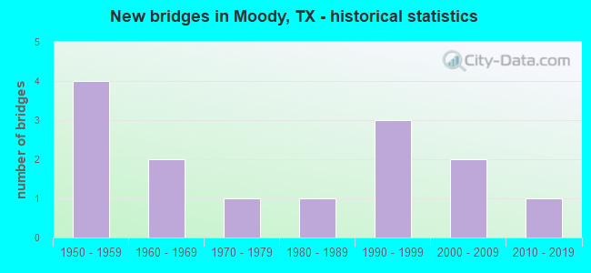
- New bridges - historical statistics
- 41950-1959
- 21960-1969
- 11970-1979
- 11980-1989
- 31990-1999
- 22000-2009
- 12010-2019


- Bridge Condition - Deck
- 30.0%Very good
- 60.0%Good
- 10.0%Satisfactory

- Bridge Condition - Superstructure
- 40.0%Good
- 60.0%Satisfactory

- Bridge Condition - Substructure
- 10.0%Good
- 80.0%Satisfactory
- 10.0%Fair

- Bridge Condition - Channel
- 7.1%Very good
- 50.0%Good
- 35.7%Satisfactory
- 7.1%Fair

- Bridge Condition - Culverts
- 50.0%Good
- 25.0%Satisfactory
- 25.0%Fair
Find on map >> Show street view
Structure Number: 90140260202001, Location: 2.98 MI W OF SH 317 (Lat: 31.274347, Lng: -97.412308), Route carried "on" structure: State highway 2601, Year Built: 1961, Status: Open, Structure Length: 4.88m (16.01ft), Average Daily Traffic: 545 (year 2020), Truck Traffic: 6%, Average Future Daily Traffic: 910 (year 2033), Design Load: H 15, Features Intersected: STAMPEDE CREEK
Minimum Vertical Clearance: 30+ m (98+ ft), Kilometerpoint: 4.432, Lanes on structure: 2, Owner: State Highway Agency, Approaching Roadway Width: 7.9m (25.9ft), Material/Design: Concrete, Design/Construction: Stringer/Multi-beam, Number Of Spans In Main Unit: 4, Length of Maximum Span: 12.2m (40.0ft), Curb-To-Curb Width: 7.1m (23.3ft), Out-to-Out Width: 7.8m (25.6ft)
Condition: Deck: Good, Superstructure: Good, Substructure: Good, Channel: Good, Operating Rating: 43.5 metric tons, Method Used To Determine Operating Rating: Load Factor (LF), Inventory Rating: 26.3 metric tons, Method Used To Determine Inventory Rating: Load Factor (LF), Structural Evaluation: Equal to present minimum criteria, Deck Geometry: Meets minimum limits, Waterway Adequacy: Better than present minimum criteria, Approach Roadway Alignment: Equal to present desirable criteria, Length Of Structure Improvement: 6.40m (21.00ft), Designated Inspection Frequency: Every 24 months, Inspection Date: January 2021, Bridge Improvement Cost: $820,000, Roadway Improvement Cost: $205,000, Total Project Cost: $1,230,000, Deck Structure Type: Concrete Cast-file-Place, Wearing Surface/Protective System: Wearing Surface: Bituminous
Find on map >> Show street view
Structure Number: 90140260202002, Location: 2.30 MI W OF SH 317 (Lat: 31.266589, Lng: -97.410172), Route carried "on" structure: State highway 2601, Year Built: 1961, Status: Open, Structure Length: 0.88m (2.89ft), Average Daily Traffic: 545 (year 2020), Truck Traffic: 6%, Average Future Daily Traffic: 910 (year 2033), Design Load: HS 20, Features Intersected: HOWARD BR
Minimum Vertical Clearance: 30+ m (98+ ft), Kilometerpoint: 5.562, Lanes on structure: 2, Owner: State Highway Agency, Approaching Roadway Width: 7.9m (25.9ft), Material/Design: Concrete, Design/Construction: Culvert, Number Of Spans In Main Unit: 3, Length of Maximum Span: 2.7m (8.9ft)
Condition: Channel: Satisfactory, Culverts: Fair, Operating Rating: 39.9 metric tons, Method Used To Determine Operating Rating: Load Factor (LF), Inventory Rating: 23.6 metric tons, Method Used To Determine Inventory Rating: Load Factor (LF), Structural Evaluation: Somewhat better than minimum adequacy, Waterway Adequacy: Better than present minimum criteria, Approach Roadway Alignment: Equal to present desirable criteria, Designated Inspection Frequency: Every 24 months, Inspection Date: January 2021
Find on map >> Show street view
Structure Number: 90140AA0130001, Location: 0.15 MI W OF MUNZ RD (Lat: 31.283253, Lng: -97.407136), Route carried "on" structure: County highway , Year Built: 1988, Status: Open, Structure Length: 3.90m (12.80ft), Average Daily Traffic: 148 (year 2020), Average Future Daily Traffic: 100 (year 2037), Features Intersected: STAMPEDE CRK #108, Facility Carried by Structure: STAMPEDE RD
Minimum Vertical Clearance: 30+ m (98+ ft), Kilometerpoint: 3.380, Lanes on structure: 2, Owner: County Highway Agency, Approaching Roadway Width: 6.1m (20.0ft), Skew: 4 degrees, Material/Design: Steel, Design/Construction: Stringer/Multi-beam, Number Of Spans In Main Unit: 2, Length of Maximum Span: 19.5m (64.0ft), Curb-To-Curb Width: 7.4m (24.3ft), Out-to-Out Width: 7.8m (25.6ft)
Condition: Deck: Good, Superstructure: Good, Substructure: Satisfactory, Channel: Satisfactory, Operating Rating: 36.3 metric tons, Method Used To Determine Operating Rating: Load Factor (LF), Inventory Rating: 21.8 metric tons, Method Used To Determine Inventory Rating: Load Factor (LF), Structural Evaluation: Equal to present minimum criteria, Deck Geometry: Somewhat better than minimum adequacy, Waterway Adequacy: Equal to present minimum criteria, Approach Roadway Alignment: Equal to present desirable criteria, Length Of Structure Improvement: 5.03m (16.50ft), Designated Inspection Frequency: Every 24 months, Inspection Date: December 2019, Bridge Improvement Cost: $460,000, Roadway Improvement Cost: $115,000, Total Project Cost: $575,000, Deck Structure Type: Concrete Cast-file-Place
Find on map >> Show street view
Structure Number: 90140AA5130001, Location: 1.2 MI SW OF FM 107 (Lat: 31.308417, Lng: -97.408000), Route carried "on" structure: County highway , Year Built: 2011, Status: Open, Structure Length: 1.10m (3.61ft), Average Daily Traffic: 100 (year 2020), Truck Traffic: 2%, Average Future Daily Traffic: 60 (year 2032), Design Load: HL 93, Features Intersected: NO NAME CREEK #654, Facility Carried by Structure: BCR 5130 (DOVE RD)
Minimum Vertical Clearance: 30+ m (98+ ft), Kilometerpoint: 0.000, Lanes on structure: 2, Owner: County Highway Agency, Approaching Roadway Width: 6.1m (20.0ft), Skew: 4 degrees, Material/Design: Concrete, Design/Construction: Culvert, Number Of Spans In Main Unit: 3, Length of Maximum Span: 3.7m (12.1ft), Curb-To-Curb Width: 7.5m (24.6ft), Out-to-Out Width: 7.9m (25.9ft)
Condition: Channel: Good, Culverts: Satisfactory, Operating Rating: 54.4 metric tons, Method Used To Determine Operating Rating: Assigned ratings based on Load and Resistance Factor Design (LRFD) reported in metric tons, Inventory Rating: 32.7 metric tons, Method Used To Determine Inventory Rating: Assigned ratings based on Load and Resistance Factor Design (LRFD) reported in metric tons, Structural Evaluation: Equal to present minimum criteria, Deck Geometry: Equal to present minimum criteria, Waterway Adequacy: Equal to present minimum criteria, Approach Roadway Alignment: Better than present minimum criteria, Designated Inspection Frequency: Every 24 months, Inspection Date: December 2019, Deck Structure Type: Concrete Cast-file-Place, Wearing Surface/Protective System: Wearing Surface: Monolithic Concrete
Find on map >> Show street view
Structure Number: 91610056705007, Location: 3.5 Mi W of SH 317 (Lat: 31.326550, Lng: -97.414422), Route carried "on" structure: State highway 107, Year Built: 1954, Status: Open, Structure Length: 1.83m (6.00ft), Average Daily Traffic: 1,404 (year 2020), Truck Traffic: 22%, Average Future Daily Traffic: 1,520 (year 2033), Features Intersected: Tributary Stampede Creek
Minimum Vertical Clearance: 30+ m (98+ ft), Kilometerpoint: 1.078, Lanes on structure: 2, Owner: State Highway Agency, Approaching Roadway Width: 8.2m (26.9ft), Material/Design: Concrete, Design/Construction: Stringer/Multi-beam, Number Of Spans In Main Unit: 2, Length of Maximum Span: 9.1m (29.9ft), Curb-To-Curb Width: 6.7m (22.0ft), Out-to-Out Width: 7.5m (24.6ft)
Condition: Deck: Good, Superstructure: Satisfactory, Substructure: Satisfactory, Channel: Satisfactory, Operating Rating: 44.4 metric tons, Method Used To Determine Operating Rating: Load Factor (LF), Inventory Rating: 29.9 metric tons, Method Used To Determine Inventory Rating: Load Factor (LF), Structural Evaluation: Equal to present minimum criteria, Deck Geometry: High priority of corrective action, Waterway Adequacy: Equal to present minimum criteria, Approach Roadway Alignment: Equal to present desirable criteria, Length Of Structure Improvement: 2.74m (8.99ft), Designated Inspection Frequency: Every 24 months, Inspection Date: December 2020, Bridge Improvement Cost: $400,000, Roadway Improvement Cost: $100,000, Total Project Cost: $600,000, Deck Structure Type: Concrete Cast-file-Place, Wearing Surface/Protective System: Wearing Surface: Bituminous
Find on map >> Show street view
Structure Number: 91610056705008, Location: 2.5 Mi W of SH 317 (Lat: 31.323914, Lng: -97.398417), Route carried "on" structure: State highway 107, Year Built: 1954, Status: Open, Structure Length: 1.83m (6.00ft), Average Daily Traffic: 2,472 (year 2020), Truck Traffic: 22%, Average Future Daily Traffic: 1,910 (year 2033), Design Load: H 15, Features Intersected: Stampede Creek
Minimum Vertical Clearance: 30+ m (98+ ft), Kilometerpoint: 2.634, Lanes on structure: 2, Owner: State Highway Agency, Approaching Roadway Width: 6.7m (22.0ft), Material/Design: Concrete, Design/Construction: Stringer/Multi-beam, Number Of Spans In Main Unit: 2, Length of Maximum Span: 9.1m (29.9ft), Curb-To-Curb Width: 6.9m (22.6ft), Out-to-Out Width: 7.5m (24.6ft)
Condition: Deck: Good, Superstructure: Good, Substructure: Satisfactory, Channel: Satisfactory, Operating Rating: 49.9 metric tons, Method Used To Determine Operating Rating: Load Factor (LF), Inventory Rating: 29.9 metric tons, Method Used To Determine Inventory Rating: Load Factor (LF), Structural Evaluation: Equal to present minimum criteria, Deck Geometry: High priority of replacement, Waterway Adequacy: Equal to present minimum criteria, Approach Roadway Alignment: Equal to present minimum criteria, Length Of Structure Improvement: 2.74m (8.99ft), Designated Inspection Frequency: Every 24 months, Inspection Date: December 2020, Bridge Improvement Cost: $400,000, Roadway Improvement Cost: $100,000, Total Project Cost: $700,000, Deck Structure Type: Concrete Cast-file-Place, Wearing Surface/Protective System: Wearing Surface: Bituminous
Find on map >> Show street view
Structure Number: 91610056705009, Location: 3.8 Mi SE of Coryell CL (Lat: 31.313675, Lng: -97.365061), Route carried "on" structure: State highway 107, Year Built: 1958, Status: Open, Structure Length: 0.79m (2.59ft), Average Daily Traffic: 2,472 (year 2020), Truck Traffic: 22%, Average Future Daily Traffic: 1,910 (year 2033), Features Intersected: Tributary Stampede Creek
Minimum Vertical Clearance: 30+ m (98+ ft), Kilometerpoint: 6.077, Lanes on structure: 2, Owner: State Highway Agency, Approaching Roadway Width: 8.5m (27.9ft), Material/Design: Concrete, Design/Construction: Culvert, Number Of Spans In Main Unit: 4, Length of Maximum Span: 1.8m (5.9ft), Curb-To-Curb Width: 7.8m (25.6ft), Out-to-Out Width: 14.6m (47.9ft)
Condition: Channel: Satisfactory, Culverts: Good, Operating Rating: 39.9 metric tons, Method Used To Determine Operating Rating: Load Factor (LF), Inventory Rating: 23.6 metric tons, Method Used To Determine Inventory Rating: Load Factor (LF), Structural Evaluation: Equal to present minimum criteria, Deck Geometry: High priority of replacement, Waterway Adequacy: Equal to present minimum criteria, Approach Roadway Alignment: Somewhat better than minimum adequacy, Length Of Structure Improvement: 1.83m (6.00ft), Designated Inspection Frequency: Every 24 months, Inspection Date: December 2020, Bridge Improvement Cost: $200,000, Roadway Improvement Cost: $100,000, Total Project Cost: $400,000, Deck Structure Type: Concrete Cast-file-Place, Wearing Surface/Protective System: Wearing Surface: Bituminous
Find on map >> Show street view
Structure Number: 91610206001007, Location: 3.2 Mi NE of FM 107 (Lat: 31.349917, Lng: -97.335558), Route carried "on" structure: State highway 2113, Year Built: 1957, Status: Open, Structure Length: 1.31m (4.30ft), Average Daily Traffic: 1,704 (year 2020), Truck Traffic: 4%, Average Future Daily Traffic: 4,910 (year 2037), Features Intersected: S Cow Bayou
Minimum Vertical Clearance: 30+ m (98+ ft), Kilometerpoint: 20.748, Lanes on structure: 2, Owner: State Highway Agency, Approaching Roadway Width: 10.7m (35.1ft), Material/Design: Concrete, Design/Construction: Culvert, Number Of Spans In Main Unit: 4, Length of Maximum Span: 3.0m (9.8ft), Curb-To-Curb Width: 9.9m (32.5ft), Out-to-Out Width: 10.8m (35.4ft)
Condition: Channel: Good, Culverts: Good, Operating Rating: 39.9 metric tons, Method Used To Determine Operating Rating: Load Factor (LF), Inventory Rating: 23.6 metric tons, Method Used To Determine Inventory Rating: Load Factor (LF), Structural Evaluation: Equal to present minimum criteria, Deck Geometry: Somewhat better than minimum adequacy, Waterway Adequacy: Equal to present minimum criteria, Approach Roadway Alignment: Equal to present desirable criteria, Length Of Structure Improvement: 1.31m (4.30ft), Designated Inspection Frequency: Every 24 months, Inspection Date: December 2020, Deck Structure Type: Concrete Cast-file-Place, Wearing Surface/Protective System: Wearing Surface: Bituminous
Find on map >> Show street view
Structure Number: 91610AA0213001, Location: 1.15 MI S OF FM 107 (Lat: 31.302389, Lng: -97.387142), Route carried "on" structure: County highway 119, Year Built: 1970, Status: Open, Structure Length: 1.28m (4.20ft), Average Daily Traffic: 100 (year 2020), Average Future Daily Traffic: 30 (year 2036), Features Intersected: BIG ELM CRK TRIB #308, Facility Carried by Structure: BLUE CUT RD S
Minimum Vertical Clearance: 30+ m (98+ ft), Kilometerpoint: 0.241, Lanes on structure: 1, Owner: County Highway Agency, Approaching Roadway Width: 6.1m (20.0ft), Material/Design: Steel, Design/Construction: Box Beam or Girders - Multiple, Number Of Spans In Main Unit: 2, Length of Maximum Span: 6.4m (21.0ft), Curb-To-Curb Width: 5.7m (18.7ft), Out-to-Out Width: 6.1m (20.0ft)
Condition: Deck: Satisfactory, Superstructure: Satisfactory, Substructure: Satisfactory, Channel: Fair, Operating Rating: 36.3 metric tons, Method Used To Determine Operating Rating: Allowable Stress (AS), Inventory Rating: 24.5 metric tons, Method Used To Determine Inventory Rating: Allowable Stress (AS), Structural Evaluation: Equal to present minimum criteria, Deck Geometry: Meets minimum limits, Waterway Adequacy: Meets minimum limits, Approach Roadway Alignment: Equal to present desirable criteria, Length Of Structure Improvement: 1.83m (6.00ft), Designated Inspection Frequency: Every 24 months, Critical Feature Inspection Frequency: Every 24 months, Inspection Date: March 2020, Critical Feature Inspection Date: March 2021, Bridge Improvement Cost: $167,000, Roadway Improvement Cost: $41,000, Total Project Cost: $208,000, Deck Structure Type: Concrete Cast-file-Place
Find on map >> Show street view
Structure Number: 91610AA0230001, Location: 0.50 MI NE OF FM 107 (Lat: 31.301461, Lng: -97.314433), Route carried "on" structure: County highway 143, Year Built: 1997, Status: Open, Structure Length: 0.76m (2.49ft), Average Daily Traffic: 168 (year 2020), Average Future Daily Traffic: 75 (year 2036), Features Intersected: W FORK DEER CRK #136, Facility Carried by Structure: DOSS LN
Minimum Vertical Clearance: 30+ m (98+ ft), Kilometerpoint: 0.805, Lanes on structure: 1, Owner: County Highway Agency, Approaching Roadway Width: 5.5m (18.0ft), Skew: 1 degrees, Material/Design: Steel, Design/Construction: Stringer/Multi-beam, Number Of Spans In Main Unit: 1, Length of Maximum Span: 7.3m (24.0ft), Curb-To-Curb Width: 7.3m (24.0ft), Out-to-Out Width: 7.3m (24.0ft)
Condition: Deck: Very good, Superstructure: Satisfactory, Substructure: Fair, Channel: Good, Operating Rating: 35.4 metric tons, Method Used To Determine Operating Rating: Allowable Stress (AS), Inventory Rating: 21.8 metric tons, Method Used To Determine Inventory Rating: Allowable Stress (AS), Structural Evaluation: Somewhat better than minimum adequacy, Deck Geometry: Somewhat better than minimum adequacy, Waterway Adequacy: Meets minimum limits, Approach Roadway Alignment: Equal to present desirable criteria, Length Of Structure Improvement: 1.83m (6.00ft), Designated Inspection Frequency: Every 24 months, Inspection Date: March 2020, Bridge Improvement Cost: $167,000, Roadway Improvement Cost: $41,000, Total Project Cost: $208,000, Deck Structure Type: Corrugated Steel, Wearing Surface/Protective System: Wearing Surface: Bituminous
Find on map >> Show street view
Structure Number: 91610AA0246001, Location: 1.70 MI NE OF SH 317 (Lat: 31.349575, Lng: -97.345931), Route carried "on" structure: County highway 123, Year Built: 1997, Status: Open, Structure Length: 0.67m (2.20ft), Average Daily Traffic: 100 (year 2020), Average Future Daily Traffic: 75 (year 2036), Features Intersected: S FORK COW BYU TRIB #184, Facility Carried by Structure: BUCKELLEN LN
Minimum Vertical Clearance: 30+ m (98+ ft), Kilometerpoint: 1.770, Lanes on structure: 1, Owner: County Highway Agency, Approaching Roadway Width: 4.3m (14.1ft), Material/Design: Steel, Design/Construction: Stringer/Multi-beam, Number Of Spans In Main Unit: 1, Length of Maximum Span: 6.4m (21.0ft), Curb-To-Curb Width: 7.3m (24.0ft), Out-to-Out Width: 7.3m (24.0ft)
Condition: Deck: Good, Superstructure: Satisfactory, Substructure: Satisfactory, Channel: Good, Operating Rating: 50.8 metric tons, Method Used To Determine Operating Rating: Allowable Stress (AS), Inventory Rating: 39.0 metric tons, Method Used To Determine Inventory Rating: Allowable Stress (AS), Structural Evaluation: Equal to present minimum criteria, Deck Geometry: Equal to present minimum criteria, Waterway Adequacy: Meets minimum limits, Approach Roadway Alignment: Equal to present desirable criteria, Designated Inspection Frequency: Every 24 months, Inspection Date: March 2020, Deck Structure Type: Corrugated Steel, Wearing Surface/Protective System: Wearing Surface: Bituminous
Find on map >> Show street view
Structure Number: 91610AA0246002, Location: 1.95 MI NE OF SH 317 (Lat: 31.352933, Lng: -97.344436), Route carried "on" structure: County highway 123, Year Built: 1997, Status: Open, Structure Length: 0.64m (2.10ft), Average Daily Traffic: 70 (year 2016), Average Future Daily Traffic: 240 (year 2036), Features Intersected: S FORK COW BYU #183, Facility Carried by Structure: BUCKELLEN LN
Minimum Vertical Clearance: 30+ m (98+ ft), Kilometerpoint: 2.253, Lanes on structure: 1, Owner: County Highway Agency, Approaching Roadway Width: 5.5m (18.0ft), Material/Design: Steel, Design/Construction: Stringer/Multi-beam, Number Of Spans In Main Unit: 1, Length of Maximum Span: 6.4m (21.0ft), Curb-To-Curb Width: 7.3m (24.0ft), Out-to-Out Width: 7.3m (24.0ft)
Condition: Deck: Very good, Superstructure: Satisfactory, Substructure: Satisfactory, Channel: Very good, Operating Rating: 51.7 metric tons, Method Used To Determine Operating Rating: Allowable Stress (AS), Inventory Rating: 39.9 metric tons, Method Used To Determine Inventory Rating: Allowable Stress (AS), Structural Evaluation: Equal to present minimum criteria, Deck Geometry: Equal to present minimum criteria, Waterway Adequacy: Meets minimum limits, Approach Roadway Alignment: Equal to present desirable criteria, Designated Inspection Frequency: Every 24 months, Inspection Date: March 2020, Deck Structure Type: Corrugated Steel, Wearing Surface/Protective System: Wearing Surface: Gravel
Find on map >> Show street view
Structure Number: 91610AA0257001, Location: 0.1 MI W OF BLUE CUT RD S (Lat: 31.300153, Lng: -97.389578), Route carried "on" structure: County highway , Year Built: 2004, Status: Open, Structure Length: 1.74m (5.71ft), Average Daily Traffic: 100 (year 2020), Average Future Daily Traffic: 70 (year 2036), Features Intersected: TRIB OF STAMPEDE CK #309, Facility Carried by Structure: WEST STOCKTON ROAD
Minimum Vertical Clearance: 30+ m (98+ ft), Kilometerpoint: 0.174, Lanes on structure: 2, Owner: County Highway Agency, Approaching Roadway Width: 5.5m (18.0ft), Material/Design: Steel, Design/Construction: Stringer/Multi-beam, Number Of Spans In Main Unit: 1, Number Of Approach Spans: 2, Length of Maximum Span: 8.8m (28.9ft), Curb-To-Curb Width: 7.2m (23.6ft), Out-to-Out Width: 7.3m (24.0ft)
Condition: Deck: Very good, Superstructure: Satisfactory, Substructure: Satisfactory, Channel: Good, Operating Rating: 39.0 metric tons, Method Used To Determine Operating Rating: Allowable Stress (AS), Inventory Rating: 25.4 metric tons, Method Used To Determine Inventory Rating: Allowable Stress (AS), Structural Evaluation: Equal to present minimum criteria, Deck Geometry: Somewhat better than minimum adequacy, Waterway Adequacy: Meets minimum limits, Approach Roadway Alignment: Equal to present desirable criteria, Designated Inspection Frequency: Every 24 months, Inspection Date: March 2020, Deck Structure Type: Corrugated Steel, Wearing Surface/Protective System: Wearing Surface: Gravel
Find on map >> Show street view
Structure Number: 91610AA1063001, Location: 0.3 MI W OF BLUE CUT RD (Lat: 31.301778, Lng: -97.395678), Route carried "on" structure: County highway , Year Built: 2008, Status: Open, Structure Length: 1.74m (5.71ft), Average Daily Traffic: 50 (year 2016), Average Future Daily Traffic: 70 (year 2036), Design Load: HS 20, Features Intersected: TRIB STAMPEDE CRK #316, Facility Carried by Structure: WEST STOCKTON RD
Minimum Vertical Clearance: 30+ m (98+ ft), Kilometerpoint: 0.174, Lanes on structure: 2, Owner: County Highway Agency, Approaching Roadway Width: 6.1m (20.0ft), Material/Design: Steel, Design/Construction: Stringer/Multi-beam, Number Of Spans In Main Unit: 1, Length of Maximum Span: 17.1m (56.1ft), Curb-To-Curb Width: 7.2m (23.6ft), Out-to-Out Width: 7.4m (24.3ft)
Condition: Deck: Good, Superstructure: Good, Substructure: Satisfactory, Channel: Good, Operating Rating: 44.4 metric tons, Method Used To Determine Operating Rating: Assigned ratings based on Allowable Stress Design (ASD) reported in metric tons, Inventory Rating: 32.7 metric tons, Method Used To Determine Inventory Rating: Assigned ratings based on Allowable Stress Design (ASD) reported in metric tons, Structural Evaluation: Equal to present minimum criteria, Deck Geometry: Somewhat better than minimum adequacy, Waterway Adequacy: Better than present minimum criteria, Approach Roadway Alignment: Equal to present desirable criteria, Designated Inspection Frequency: Every 24 months, Inspection Date: March 2020, Deck Structure Type: Concrete Cast-file-Place, Wearing Surface/Protective System: Wearing Surface: Gravel