Bridge Statistics for Montrose, Michigan (MI)
Condition, Traffic, Stress, Structural Evaluation, Project Costs
- National Bridge Inventory (NBI) Statistics
- 11Number of bridges
- 82ft / 25.0mTotal length
- $85,000Total costs
- 39,129Total average daily traffic
- 2,601Total average daily truck traffic
- 45,259Total future (year 2018) average daily traffic
- National Bridge Inventory (NBI) Registered Bridges for Montrose
- No street view available for this location
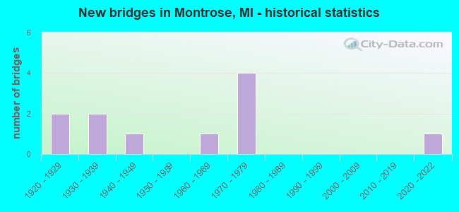
- New bridges - historical statistics
- 21920-1929
- 21930-1939
- 11940-1949
- 11960-1969
- 41970-1979
- 12020-2022

- Reconstructed bridges - Historical Statistics
- 11980-1989
- 11990-1999


- Bridge Condition - Deck
- 12.5%Good
- 75.0%Satisfactory
- 12.5%Fair

- Bridge Condition - Superstructure
- 12.5%Very good
- 12.5%Good
- 50.0%Satisfactory
- 25.0%Fair

- Bridge Condition - Substructure
- 50.0%Satisfactory
- 50.0%Fair

- Bridge Condition - Channel
- 9.1%Very good
- 18.2%Good
- 9.1%Satisfactory
- 45.5%Fair
- 18.2%Poor

- Bridge Condition - Culverts
- 33.3%Excellent
- 66.7%Fair
Find on map >> Show street view
Structure Number: 2618, Location: 1.0 MI E OF MONTROSE (Lat: 43.176242, Lng: -83.877789), Route carried "on" structure: State highway 57, Year Built: 1926, Year Reconstructed: 1992, Status: Open, Structure Length: 10.73m (35.20ft), Average Daily Traffic: 11,915 (year 2007), Truck Traffic: 7%, Average Future Daily Traffic: 12,962 (year 2018), Design Load: H 15, Features Intersected: FLINT RIVER
Minimum Vertical Clearance: 30.48m (100.00ft), Kilometerpoint: 4.295, Lanes on structure: 2, Base Highway Network: Yes (Inventory Route: 149, Subroute: 3), Owner: State Highway Agency, Approaching Roadway Width: 13.7m (44.9ft), Skew: 4 degrees, Material/Design: Prestressed concrete, Design/Construction: Stringer/Multi-beam, Number Of Spans In Main Unit: 5, Length of Maximum Span: 21.3m (69.9ft), Curb-To-Curb Width: 13.4m (44.0ft), Out-to-Out Width: 14.3m (46.9ft)
Condition: Deck: Satisfactory, Superstructure: Fair, Substructure: Fair, Channel: Fair, Operating Rating: 72.6 metric tons, Method Used To Determine Operating Rating: Load Factor (LF) rating reported by rating factor (RF) method using MS18 loading, Inventory Rating: 40.5 metric tons, Method Used To Determine Inventory Rating: Load Factor (LF) rating reported by rating factor (RF) method using MS18 loading, Structural Evaluation: Somewhat better than minimum adequacy, Deck Geometry: Equal to present minimum criteria, Waterway Adequacy: Somewhat better than minimum adequacy, Approach Roadway Alignment: Somewhat better than minimum adequacy, Designated Inspection Frequency: Every 24 months, Inspection Date: August 2020, Deck Structure Type: Concrete Cast-file-Place, Wearing Surface/Protective System: Wearing Surface: Monolithic Concrete, Deck Protection: Epoxy Coated Reinforcing
Find on map >> Show street view
Structure Number: 2619, Location: 1.9 MI E OF MONTROSE (Lat: 43.176858, Lng: -83.856153), Route carried "on" structure: State highway 57, Year Built: 1966, Status: Open, Structure Length: 3.59m (11.78ft), Average Daily Traffic: 11,915 (year 2007), Truck Traffic: 7%, Average Future Daily Traffic: 12,962 (year 2018), Design Load: H 20, Features Intersected: BRENT RUN CREEK
Minimum Vertical Clearance: 30.48m (100.00ft), Kilometerpoint: 6.056, Lanes on structure: 2, Base Highway Network: Yes (Inventory Route: 149, Subroute: 3), Owner: State Highway Agency, Approaching Roadway Width: 14.0m (45.9ft), Material/Design: Prestressed concrete, Design/Construction: Stringer/Multi-beam, Number Of Spans In Main Unit: 3, Length of Maximum Span: 12.2m (40.0ft), Curb or Sidewalk Widths: Left: 0.2m (0.7ft), Right: 0.2m (0.7ft), Curb-To-Curb Width: 13.4m (44.0ft), Out-to-Out Width: 14.1m (46.3ft)
Condition: Deck: Satisfactory, Superstructure: Good, Substructure: Satisfactory, Channel: Good, Operating Rating: 51.5 metric tons, Method Used To Determine Operating Rating: Load Factor (LF) rating reported by rating factor (RF) method using MS18 loading, Inventory Rating: 30.8 metric tons, Method Used To Determine Inventory Rating: Load Factor (LF) rating reported by rating factor (RF) method using MS18 loading, Structural Evaluation: Equal to present minimum criteria, Deck Geometry: Equal to present minimum criteria, Waterway Adequacy: Equal to present desirable criteria, Approach Roadway Alignment: Equal to present desirable criteria, Designated Inspection Frequency: Every 24 months, Inspection Date: March 2021, Deck Structure Type: Concrete Cast-file-Place, Wearing Surface/Protective System: Wearing Surface: Latex Concrete
Find on map >> Show street view
Structure Number: 2727, Location: BET DUFFIELD & NICHOLS RD (Lat: 43.117947, Lng: -83.893786), Route carried "on" structure: County highway 2574, Year Built: 2020, Status: Open, Structure Length: 0.74m (2.43ft), Average Daily Traffic: 6,497 (year 2019), Truck Traffic: 5%, Average Future Daily Traffic: 7,136 (year 2039), Design Load: Greater than HL93, Features Intersected: BRENT CREEK, Facility Carried by Structure: MT MORRIS ROAD
Minimum Vertical Clearance: 30.48m (100.00ft), Kilometerpoint: 2.857, Lanes on structure: 2, Owner: County Highway Agency, Approaching Roadway Width: 9.8m (32.2ft), Material/Design: Aluminum, Iron, Design/Construction: Culvert, Number Of Spans In Main Unit: 1, Length of Maximum Span: 7.4m (24.3ft)
Condition: Channel: Very good, Culverts: Excellent, Operating Rating: 80.7 metric tons, Method Used To Determine Operating Rating: Load and Resistance Factor Rating (LRFR) rating reported by rating factor(RF) method using HL-93 loadings, Inventory Rating: 62.2 metric tons, Method Used To Determine Inventory Rating: Load and Resistance Factor Rating (LRFR) rating reported by rating factor(RF) method using HL-93 loadings, Structural Evaluation: Superior to present desirable criteria, Waterway Adequacy: Better than present minimum criteria, Approach Roadway Alignment: Equal to present desirable criteria, Length Of Structure Improvement: 0.76m (2.49ft), Designated Inspection Frequency: Every 24 months, Inspection Date: November 2020, Bridge Improvement Cost: $60,000, Roadway Improvement Cost: $6,000, Total Project Cost: $75,000, Wearing Surface/Protective System: Wearing Surface: Bituminous
Find on map >> Show street view
Structure Number: 2787, Location: BET MT MORRIS & FRANCES (Lat: 43.119308, Lng: -83.892575), Route carried "on" structure: County highway , Year Built: 1926, Status: Posted for load, Structure Length: 0.70m (2.30ft), Average Daily Traffic: 334 (year 2009), Truck Traffic: 2%, Average Future Daily Traffic: 603 (year 2029), Design Load: HS 20+Mod, Features Intersected: BRENT CREEK, Facility Carried by Structure: NICHOLS ROAD
Minimum Vertical Clearance: 30.48m (100.00ft), Kilometerpoint: 1.770, Lanes on structure: 2, Owner: County Highway Agency, Approaching Roadway Width: 9.1m (29.9ft), Material/Design: Concrete, Design/Construction: Tee Beam, Number Of Spans In Main Unit: 1, Length of Maximum Span: 6.7m (22.0ft), Curb-To-Curb Width: 7.9m (25.9ft), Out-to-Out Width: 8.6m (28.2ft)
Condition: Deck: Satisfactory, Superstructure: Satisfactory, Substructure: Fair, Channel: Fair, Operating Rating: 28.2 metric tons, Method Used To Determine Operating Rating: Load Factor (LF) rating reported by rating factor (RF) method using MS18 loading, Inventory Rating: 16.8 metric tons, Method Used To Determine Inventory Rating: Load Factor (LF) rating reported by rating factor (RF) method using MS18 loading, Structural Evaluation: Somewhat better than minimum adequacy, Deck Geometry: Somewhat better than minimum adequacy, Waterway Adequacy: Equal to present desirable criteria, Approach Roadway Alignment: Equal to present desirable criteria, Bridge Posting: Required (Relationship of Operating Rating to Maximum Legal Load: 10.0 - 19.9% below), Designated Inspection Frequency: Every 24 months, Inspection Date: November 2020, Deck Structure Type: Concrete Cast-file-Place, Wearing Surface/Protective System: Wearing Surface: Monolithic Concrete
Find on map >> Show street view
Structure Number: 2795, Location: BET MORRISH + MCKINLEY (Lat: 43.162389, Lng: -83.836911), Route carried "on" structure: County highway , Year Built: 1971, Status: Posted for load, Structure Length: 0.79m (2.59ft), Average Daily Traffic: 215 (year 2009), Truck Traffic: 2%, Average Future Daily Traffic: 395 (year 2029), Design Load: HS 20+Mod, Features Intersected: CENTRAL DRAIN, Facility Carried by Structure: WILSON ROAD
Minimum Vertical Clearance: 30.48m (100.00ft), Kilometerpoint: 2.157, Lanes on structure: 2, Owner: County Highway Agency, Approaching Roadway Width: 11.0m (36.1ft), Material/Design: Wood or Timber, Design/Construction: Slab, Number Of Spans In Main Unit: 1, Length of Maximum Span: 7.3m (24.0ft), Curb-To-Curb Width: 10.1m (33.1ft), Out-to-Out Width: 10.7m (35.1ft)
Condition: Deck: Satisfactory, Superstructure: Satisfactory, Substructure: Fair, Channel: Fair, Operating Rating: 16.2 metric tons, Method Used To Determine Operating Rating: Allowable Stress (AS) rating reported by rating factor (RF) method using MS18 loading, Inventory Rating: 11.7 metric tons, Method Used To Determine Inventory Rating: Allowable Stress (AS) rating reported by rating factor (RF) method using MS18 loading, Structural Evaluation: Meets minimum limits, Deck Geometry: Better than present minimum criteria, Waterway Adequacy: Equal to present desirable criteria, Approach Roadway Alignment: Equal to present desirable criteria, Bridge Posting: Required (Relationship of Operating Rating to Maximum Legal Load: > 39.9% below), Designated Inspection Frequency: Every 6 months, Inspection Date: November 2021, Deck Structure Type: Wood or Timber, Wearing Surface/Protective System: Wearing Surface: Bituminous
Find on map >> Show street view
Structure Number: 2799, Location: BET WILSON + DODGE ROAD (Lat: 43.161458, Lng: -83.833644), Route carried "on" structure: County highway , Year Built: 1971, Status: Posted for load, Structure Length: 0.79m (2.59ft), Average Daily Traffic: 219 (year 2009), Truck Traffic: 2%, Average Future Daily Traffic: 396 (year 2029), Design Load: HS 20+Mod, Features Intersected: CENTRAL DRAIN, Facility Carried by Structure: MORRISH ROAD
Minimum Vertical Clearance: 30.48m (100.00ft), Kilometerpoint: 4.830, Lanes on structure: 2, Owner: County Highway Agency, Approaching Roadway Width: 11.0m (36.1ft), Material/Design: Wood or Timber, Design/Construction: Slab, Number Of Spans In Main Unit: 1, Length of Maximum Span: 7.3m (24.0ft), Curb-To-Curb Width: 10.1m (33.1ft), Out-to-Out Width: 10.7m (35.1ft)
Condition: Deck: Satisfactory, Superstructure: Satisfactory, Substructure: Fair, Channel: Poor, Operating Rating: 15.6 metric tons, Method Used To Determine Operating Rating: Allowable Stress (AS) rating reported by rating factor (RF) method using MS18 loading, Inventory Rating: 11.0 metric tons, Method Used To Determine Inventory Rating: Allowable Stress (AS) rating reported by rating factor (RF) method using MS18 loading, Structural Evaluation: Meets minimum limits, Deck Geometry: Better than present minimum criteria, Waterway Adequacy: Equal to present desirable criteria, Approach Roadway Alignment: Equal to present desirable criteria, Bridge Posting: Required (Relationship of Operating Rating to Maximum Legal Load: > 39.9% below), Designated Inspection Frequency: Every 12 months, Inspection Date: November 2021, Deck Structure Type: Wood or Timber, Wearing Surface/Protective System: Wearing Surface: Bituminous
Find on map >> Show street view
Structure Number: 28, Location: BET WILSON & VIENNA ROAD (Lat: 43.169825, Lng: -83.833636), Route carried "on" structure: County highway , Year Built: 1930, Status: Posted for load, Structure Length: 0.82m (2.69ft), Average Daily Traffic: 426 (year 2009), Truck Traffic: 2%, Average Future Daily Traffic: 769 (year 2029), Design Load: HS 20+Mod, Features Intersected: BRENT RUN, Facility Carried by Structure: MORRISH ROAD
Minimum Vertical Clearance: 30.48m (100.00ft), Kilometerpoint: 5.760, Lanes on structure: 2, Owner: County Highway Agency, Approaching Roadway Width: 10.1m (33.1ft), Material/Design: Concrete, Design/Construction: Tee Beam, Number Of Spans In Main Unit: 1, Length of Maximum Span: 7.9m (25.9ft), Curb-To-Curb Width: 9.1m (29.9ft), Out-to-Out Width: 9.7m (31.8ft)
Condition: Deck: Good, Superstructure: Satisfactory, Substructure: Satisfactory, Channel: Fair, Operating Rating: 26.9 metric tons, Method Used To Determine Operating Rating: Load Factor (LF) rating reported by rating factor (RF) method using MS18 loading, Inventory Rating: 16.2 metric tons, Method Used To Determine Inventory Rating: Load Factor (LF) rating reported by rating factor (RF) method using MS18 loading, Structural Evaluation: Somewhat better than minimum adequacy, Deck Geometry: Equal to present minimum criteria, Waterway Adequacy: Equal to present desirable criteria, Approach Roadway Alignment: Equal to present desirable criteria, Bridge Posting: Required (Relationship of Operating Rating to Maximum Legal Load: > 39.9% below), Designated Inspection Frequency: Every 24 months, Inspection Date: November 2020, Deck Structure Type: Concrete Cast-file-Place, Wearing Surface/Protective System: Wearing Surface: Bituminous
Find on map >> Show street view
Structure Number: 9039, Location: 0.6 MI W OF GENESEE COL (Lat: 43.176119, Lng: -83.942550), Route carried "on" structure: State highway 57, Year Built: 1940, Year Reconstructed: 1990, Status: Open, Structure Length: 3.66m (12.01ft), Average Daily Traffic: 5,039 (year 2007), Truck Traffic: 10%, Average Future Daily Traffic: 5,733 (year 2018), Design Load: H 20, Features Intersected: MISTEQUAY CREEK
Minimum Vertical Clearance: 30.48m (100.00ft), Kilometerpoint: 13.606, Lanes on structure: 2, Base Highway Network: Yes (Inventory Route: 46, Subroute: 2), Owner: State Highway Agency, Approaching Roadway Width: 7.3m (24.0ft), Skew: 3 degrees, Material/Design: Prestressed concrete, Design/Construction: Stringer/Multi-beam, Number Of Spans In Main Unit: 3, Length of Maximum Span: 12.2m (40.0ft), Curb-To-Curb Width: 14.6m (47.9ft), Out-to-Out Width: 15.6m (51.2ft)
Condition: Deck: Satisfactory, Superstructure: Very good, Substructure: Satisfactory, Channel: Satisfactory, Operating Rating: 51.5 metric tons, Method Used To Determine Operating Rating: Load Factor (LF) rating reported by rating factor (RF) method using MS18 loading, Inventory Rating: 29.8 metric tons, Method Used To Determine Inventory Rating: Load Factor (LF) rating reported by rating factor (RF) method using MS18 loading, Structural Evaluation: Equal to present minimum criteria, Deck Geometry: Superior to present desirable criteria, Waterway Adequacy: Equal to present minimum criteria, Approach Roadway Alignment: Equal to present desirable criteria, Designated Inspection Frequency: Every 24 months, Inspection Date: July 2021, Deck Structure Type: Concrete Cast-file-Place, Wearing Surface/Protective System: Wearing Surface: Latex Concrete, Membrane: Preformed Fabric
Find on map >> Show street view
Structure Number: 9364, Location: 0.4 MI E OF EAST ROAD (Lat: 43.161608, Lng: -83.940617), Route carried "on" structure: ServiceCounty highway , Year Built: 1972, Status: Open, Structure Length: 1.40m (4.59ft), Average Daily Traffic: 445 (year 2010), Truck Traffic: 5%, Average Future Daily Traffic: 467 (year 2020), Design Load: H 20, Features Intersected: MISTEGUAY CREEK, Facility Carried by Structure: FERDEN ROAD
Minimum Vertical Clearance: 30.48m (100.00ft), Kilometerpoint: 8.937, Lanes on structure: 2, Owner: County Highway Agency, Approaching Roadway Width: 9.8m (32.2ft), Material/Design: Steel, Design/Construction: Stringer/Multi-beam, Number Of Spans In Main Unit: 1, Length of Maximum Span: 13.1m (43.0ft), Curb-To-Curb Width: 7.9m (25.9ft), Out-to-Out Width: 7.9m (25.9ft)
Condition: Deck: Fair, Superstructure: Fair, Substructure: Satisfactory, Channel: Good, Operating Rating: 58.0 metric tons, Method Used To Determine Operating Rating: Load Factor (LF) rating reported by rating factor (RF) method using MS18 loading, Inventory Rating: 34.7 metric tons, Method Used To Determine Inventory Rating: Load Factor (LF) rating reported by rating factor (RF) method using MS18 loading, Structural Evaluation: Somewhat better than minimum adequacy, Deck Geometry: Somewhat better than minimum adequacy, Waterway Adequacy: Equal to present desirable criteria, Approach Roadway Alignment: Equal to present desirable criteria, Length Of Structure Improvement: 3.05m (10.01ft), Designated Inspection Frequency: Every 24 months, Inspection Date: July 2020, Bridge Improvement Cost: $10,000, Total Project Cost: $10,000, Deck Structure Type: Corrugated Steel, Wearing Surface/Protective System: Wearing Surface: Bituminous
Find on map >> Show street view
Structure Number: 126, Location: BET MCKINLEY & MORRISH (Lat: 43.147844, Lng: -83.846469), Route carried "on" structure: County highway , Year Built: 1970, Status: Open, Structure Length: 1.06m (3.48ft), Average Daily Traffic: 661 (year 2016), Truck Traffic: 3%, Average Future Daily Traffic: 1,194 (year 2036), Design Load: HS 20+Mod, Features Intersected: ARMSTRONG CREEK, Facility Carried by Structure: DODGE ROAD
Minimum Vertical Clearance: 30.48m (100.00ft), Kilometerpoint: 1.230, Lanes on structure: 2, Owner: County Highway Agency, Approaching Roadway Width: 11.0m (36.1ft), Material/Design: Steel, Design/Construction: Culvert, Number Of Spans In Main Unit: 2, Length of Maximum Span: 4.8m (15.7ft)
Condition: Channel: Fair, Culverts: Fair, Operating Rating: 93.0 metric tons, Method Used To Determine Operating Rating: Load Factor (LF) rating reported by rating factor (RF) method using MS18 loading, Inventory Rating: 55.7 metric tons, Method Used To Determine Inventory Rating: Load Factor (LF) rating reported by rating factor (RF) method using MS18 loading, Structural Evaluation: Somewhat better than minimum adequacy, Waterway Adequacy: Superior to present desirable criteria, Approach Roadway Alignment: Equal to present desirable criteria, Designated Inspection Frequency: Every 24 months, Inspection Date: November 2020
Find on map >> Show street view
Structure Number: 12617, Location: BET DODGE & WILSON (Lat: 43.159278, Lng: -83.863472), Route carried "on" structure: County highway 725, Year Built: 1930, Status: Open, Structure Length: 0.76m (2.49ft), Average Daily Traffic: 1,463 (year 2017), Truck Traffic: 3%, Average Future Daily Traffic: 2,642 (year 2037), Design Load: HS 20+Mod, Features Intersected: ARMSTRONG CREEK, Facility Carried by Structure: MCKINLEY ROAD
Minimum Vertical Clearance: 30.48m (100.00ft), Kilometerpoint: 11.229, Lanes on structure: 2, Owner: County Highway Agency, Approaching Roadway Width: 10.1m (33.1ft), Material/Design: Concrete, Design/Construction: Culvert, Number Of Spans In Main Unit: 2, Length of Maximum Span: 3.6m (11.8ft)
Condition: Channel: Poor, Culverts: Fair, Operating Rating: 54.5 metric tons, Method Used To Determine Operating Rating: Field evaluation and documented engineering judgment, Inventory Rating: 32.7 metric tons, Method Used To Determine Inventory Rating: Field evaluation and documented engineering judgment, Structural Evaluation: Somewhat better than minimum adequacy, Waterway Adequacy: Superior to present desirable criteria, Approach Roadway Alignment: Equal to present desirable criteria, Designated Inspection Frequency: Every 12 months, Inspection Date: November 2021, Wearing Surface/Protective System: Wearing Surface: Bituminous