Bridge Statistics for Montoursville, Pennsylvania (PA)
Condition, Traffic, Stress, Structural Evaluation, Project Costs
- National Bridge Inventory (NBI) Statistics
- 36Number of bridges
- 518ft / 158mTotal length
- $9,174,000Total costs
- 255,573Total average daily traffic
- 22,204Total average daily truck traffic
- National Bridge Inventory (NBI) Registered Bridges for Montoursville
- No street view available for this location
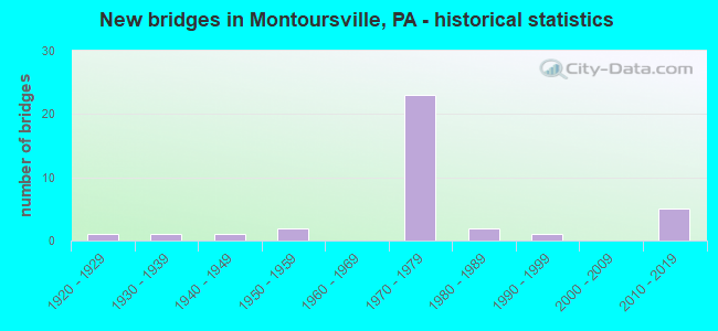
- New bridges - historical statistics
- 11920-1929
- 11930-1939
- 11940-1949
- 21950-1959
- 231970-1979
- 21980-1989
- 11990-1999
- 52010-2019

- Reconstructed bridges - Historical Statistics
- 11950-1959
- 01960-1969
- 01970-1979
- 11980-1989
- 11990-1999
- 52000-2009
- 12010-2019


- Bridge Condition - Deck
- 23.8%Very good
- 61.9%Good
- 4.8%Satisfactory
- 4.8%Fair
- 4.8%Serious

- Bridge Condition - Superstructure
- 18.2%Very good
- 54.5%Good
- 22.7%Satisfactory
- 4.5%Serious

- Bridge Condition - Substructure
- 9.1%Very good
- 36.4%Good
- 50.0%Satisfactory
- 4.5%Fair

- Bridge Condition - Channel
- 25.0%Very good
- 18.8%Good
- 25.0%Satisfactory
- 18.8%Fair
- 12.5%Poor

- Bridge Condition - Culverts
- 50.0%Very good
- 50.0%Good
Find on map >> Show street view
Structure Number: 647, Location: 1 MI.S.W. OF TARENTUM BRG (Lat: 40.587919, Lng: -79.776978), Route carried "on" structure: State highway 28, Year Built: 1976, Year Reconstructed: 2008, Status: Open, Structure Length: 13.41m (44.00ft), Average Daily Traffic: 24,309 (year 2022), Truck Traffic: 4%, Average Future Daily Traffic: 22,414 (year 2032), Design Load: HS 20, Features Intersected: BAILEYS RUN RD.,CREEK
Minimum Vertical Clearance: 30+ m (98+ ft), Kilometerpoint: 27.156, Lanes on structure: 3, Lanes under structure: 2, Base Highway Network: Yes, Owner: State Highway Agency, Approaching Roadway Width: 16.5m (54.1ft), Skew: 13 degrees, Material/Design: Steel continuous, Design/Construction: Stringer/Multi-beam, Number Of Spans In Main Unit: 4, Length of Maximum Span: 36.9m (121.1ft), Curb or Sidewalk Widths: Left: 0.2m (0.7ft), Right: 0.2m (0.7ft), Curb-To-Curb Width: 15.8m (51.8ft), Out-to-Out Width: 17.1m (56.1ft)
Condition: Deck: Good, Superstructure: Good, Substructure: Good, Channel: Satisfactory, Operating Rating: 62.6 metric tons, Method Used To Determine Operating Rating: Load Factor (LF), Inventory Rating: 37.2 metric tons, Method Used To Determine Inventory Rating: Load Factor (LF), Structural Evaluation: Better than present minimum criteria, Deck Geometry: Somewhat better than minimum adequacy, Underclear: Superior to present desirable criteria, Waterway Adequacy: Superior to present desirable criteria, Approach Roadway Alignment: Equal to present desirable criteria, Length Of Structure Improvement: 14.10m (46.26ft), Designated Inspection Frequency: Every 24 months, Inspection Date: June 2021, Bridge Improvement Cost: $114,000, Roadway Improvement Cost: $335,000, Total Project Cost: $1,537,000, Deck Structure Type: Concrete Cast-file-Place, Wearing Surface/Protective System: Wearing Surface: Latex Concrete
Find on map >> Show street view
Structure Number: 2464, Location: 301121 MARKET ST OV PKWY (Lat: 40.437936, Lng: -80.004433), Route carried "on" structure: City street , Year Built: 1940, Year Reconstructed: 2002, Status: Open, Structure Length: 2.23m (7.32ft), Average Daily Traffic: 2,824 (year 2020), Truck Traffic: 6%, Average Future Daily Traffic: 4,000 (year 2037), Design Load: HS 20, Features Intersected: I-376(WB),FORT PITT BLVD, Facility Carried by Structure: MARKET ST
Minimum Vertical Clearance: 30+ m (98+ ft), Kilometerpoint: 0.000, Lanes on structure: 2, Lanes under structure: 4, Owner: City or Municipal Highway Agency, Approaching Roadway Width: 30.5m (100.1ft), Skew: 30 degrees, Material/Design: Steel, Design/Construction: Stringer/Multi-beam, Number Of Spans In Main Unit: 1, Length of Maximum Span: 20.7m (67.9ft), Curb or Sidewalk Widths: Left: 0.2m (0.7ft), Right: 0.2m (0.7ft), Curb-To-Curb Width: 18.9m (62.0ft), Out-to-Out Width: 23.8m (78.1ft)
Condition: Deck: Good, Superstructure: Good, Substructure: Satisfactory, Operating Rating: 69.9 metric tons, Method Used To Determine Operating Rating: Load and Resistance Factor (LRFR), Inventory Rating: 53.5 metric tons, Method Used To Determine Inventory Rating: Load and Resistance Factor (LRFR), Structural Evaluation: Equal to present minimum criteria, Deck Geometry: Superior to present desirable criteria, Underclear: High priority of corrective action, Approach Roadway Alignment: Better than present minimum criteria, Length Of Structure Improvement: 2.10m (6.89ft), Designated Inspection Frequency: Every 24 months, Inspection Date: December 2020, Deck Structure Type: Concrete Cast-file-Place, Wearing Surface/Protective System: Wearing Surface: Monolithic Concrete, Deck Protection: Epoxy Coated Reinforcing
Find on map >> Show street view
Structure Number: 2459, Location: 0.25 MI N OF MONTOURSVILL (Lat: 41.268586, Lng: -76.913208), Route carried "on" structure: State highway 87, Year Built: 1989, Status: Open, Structure Length: 2.13m (6.99ft), Average Daily Traffic: 8,551 (year 2022), Truck Traffic: 7%, Average Future Daily Traffic: 10,498 (year 2032), Design Load: HS 25 or greater, Features Intersected: MILL CREEK
Minimum Vertical Clearance: 30+ m (98+ ft), Kilometerpoint: 0.549, Lanes on structure: 2, Owner: State Highway Agency, Approaching Roadway Width: 13.4m (44.0ft), Skew: 4 degrees, Material/Design: Prestressed concrete, Design/Construction: Box Beam or Girders - Single/Spread, Number Of Spans In Main Unit: 1, Length of Maximum Span: 20.7m (67.9ft), Curb or Sidewalk Widths: Left: 0.2m (0.7ft), Right: 0.2m (0.7ft), Curb-To-Curb Width: 13.4m (44.0ft), Out-to-Out Width: 14.5m (47.6ft)
Condition: Deck: Good, Superstructure: Good, Substructure: Good, Channel: Good, Inventory Rating: 58.1 metric tons, Method Used To Determine Inventory Rating: Load Factor (LF), Structural Evaluation: Better than present minimum criteria, Deck Geometry: Equal to present minimum criteria, Waterway Adequacy: Superior to present desirable criteria, Approach Roadway Alignment: Equal to present desirable criteria, Length Of Structure Improvement: 2.10m (6.89ft), Designated Inspection Frequency: Every 48 months, Inspection Date: January 2020, Deck Structure Type: Concrete Cast-file-Place, Wearing Surface/Protective System: Wearing Surface: Bituminous, Membrane: Preformed Fabric
Find on map >> Show street view
Structure Number: 24592, Location: VILLAGE OF LOYALSOCKVILLE (Lat: 41.319558, Lng: -76.910156), Route carried "on" structure: State highway 87, Year Built: 1928, Year Reconstructed: 1956, Status: Open, Structure Length: 0.85m (2.79ft), Average Daily Traffic: 5,763 (year 2022), Truck Traffic: 7%, Average Future Daily Traffic: 6,777 (year 2032), Design Load: HS 20, Features Intersected: OVER GRAVEL RUN
Minimum Vertical Clearance: 30+ m (98+ ft), Kilometerpoint: 6.259, Lanes on structure: 2, Base Highway Network: Yes, Owner: State Highway Agency, Approaching Roadway Width: 7.0m (23.0ft), Skew: 1 degrees, Material/Design: Concrete, Design/Construction: Tee Beam, Number Of Spans In Main Unit: 1, Length of Maximum Span: 7.6m (24.9ft), Curb-To-Curb Width: 12.2m (40.0ft), Out-to-Out Width: 13.1m (43.0ft)
Condition: Superstructure: Satisfactory, Substructure: Satisfactory, Channel: Fair, Operating Rating: 54.4 metric tons, Method Used To Determine Operating Rating: Field evaluation and documented engineering judgment, Inventory Rating: 32.7 metric tons, Method Used To Determine Inventory Rating: Field evaluation and documented engineering judgment, Structural Evaluation: Equal to present minimum criteria, Deck Geometry: Somewhat better than minimum adequacy, Waterway Adequacy: Equal to present minimum criteria, Approach Roadway Alignment: Equal to present desirable criteria, Length Of Structure Improvement: 0.90m (2.95ft), Designated Inspection Frequency: Every 24 months, Inspection Date: December 2020, Bridge Improvement Cost: $9,000, Roadway Improvement Cost: $50,000, Total Project Cost: $118,000
Find on map >> Show street view
Structure Number: 2464, Location: BOROUGH OF MONTOURSVILLE (Lat: 41.249778, Lng: -76.938642), Route carried "on" structure: Interstate 180, Year Built: 1976, Status: Open, Structure Length: 27.37m (89.80ft), Average Daily Traffic: 13,730 (year 2021), Truck Traffic: 10%, Average Future Daily Traffic: 21,735 (year 2032), Design Load: HS 20, Features Intersected: SR8034/2039/LOYALSOCK CK
Minimum Vertical Clearance: 30+ m (98+ ft), Kilometerpoint: 9.492, Lanes on structure: 2, Lanes under structure: 6, Base Highway Network: Yes, Owner: State Highway Agency, Approaching Roadway Width: 7.3m (24.0ft), Skew: 10 degrees, Material/Design: Steel continuous, Design/Construction: Stringer/Multi-beam, Number Of Spans In Main Unit: 7, Length of Maximum Span: 48.8m (160.1ft), Curb or Sidewalk Widths: Left: 0.2m (0.7ft), Right: 0.2m (0.7ft), Curb-To-Curb Width: 13.2m (43.3ft), Out-to-Out Width: 13.9m (45.6ft)
Condition: Deck: Very good, Superstructure: Satisfactory, Substructure: Satisfactory, Channel: Satisfactory, Operating Rating: 40.8 metric tons, Method Used To Determine Operating Rating: Load Factor (LF), Inventory Rating: 24.5 metric tons, Method Used To Determine Inventory Rating: Load Factor (LF), Structural Evaluation: Equal to present minimum criteria, Deck Geometry: Superior to present desirable criteria, Underclear: High priority of corrective action, Waterway Adequacy: Superior to present desirable criteria, Approach Roadway Alignment: Equal to present desirable criteria, Length Of Structure Improvement: 27.40m (89.90ft), Designated Inspection Frequency: Every 24 months, Inspection Date: June 2020, Bridge Improvement Cost: $203,000, Roadway Improvement Cost: $599,000, Total Project Cost: $2,745,000, Deck Structure Type: Concrete Cast-file-Place, Wearing Surface/Protective System: Wearing Surface: Epoxy Overlay, Deck Protection: Epoxy Coated Reinforcing
Find on map >> Show street view
Structure Number: 24641, Location: BOROUGH OF MONTOURSVILLE (Lat: 41.249972, Lng: -76.938611), Route carried "on" structure: Interstate 180, Year Built: 1976, Year Reconstructed: 2000, Status: Open, Structure Length: 27.37m (89.80ft), Average Daily Traffic: 14,690 (year 2021), Truck Traffic: 11%, Average Future Daily Traffic: 21,238 (year 2032), Design Load: HS 20, Features Intersected: SR8034/2039/LOYALSOCK CK
Minimum Vertical Clearance: 30+ m (98+ ft), Kilometerpoint: 9.461, Lanes on structure: 2, Lanes under structure: 6, Base Highway Network: Yes, Owner: State Highway Agency, Approaching Roadway Width: 7.3m (24.0ft), Skew: 10 degrees, Material/Design: Steel continuous, Design/Construction: Stringer/Multi-beam, Number Of Spans In Main Unit: 7, Length of Maximum Span: 48.8m (160.1ft), Curb or Sidewalk Widths: Left: 0.2m (0.7ft), Right: 0.2m (0.7ft), Curb-To-Curb Width: 13.2m (43.3ft), Out-to-Out Width: 13.9m (45.6ft)
Condition: Deck: Good, Superstructure: Satisfactory, Substructure: Satisfactory, Channel: Satisfactory, Operating Rating: 51.7 metric tons, Method Used To Determine Operating Rating: Load Factor (LF), Inventory Rating: 19.1 metric tons, Method Used To Determine Inventory Rating: Load Factor (LF), Structural Evaluation: Meets minimum limits, Deck Geometry: Superior to present desirable criteria, Underclear: Meets minimum limits, Waterway Adequacy: Superior to present desirable criteria, Approach Roadway Alignment: Equal to present desirable criteria, Length Of Structure Improvement: 27.40m (89.90ft), Designated Inspection Frequency: Every 24 months, Inspection Date: June 2020, Bridge Improvement Cost: $302,000, Roadway Improvement Cost: $890,000, Total Project Cost: $4,078,000, Deck Structure Type: Concrete Cast-file-Place, Wearing Surface/Protective System: Wearing Surface: Epoxy Overlay, Deck Protection: Epoxy Coated Reinforcing
Find on map >> Show street view
Structure Number: 24644, Location: BOROUGH OF MONTOURSVILLE (Lat: 41.263614, Lng: -76.914156), Route carried "on" structure: Interstate 180, Year Built: 1976, Year Reconstructed: 2007, Status: Open, Structure Length: 5.58m (18.31ft), Average Daily Traffic: 14,415 (year 2021), Truck Traffic: 10%, Average Future Daily Traffic: 21,981 (year 2032), Design Load: HS 20, Features Intersected: OVER SR 2075
Minimum Vertical Clearance: 30+ m (98+ ft), Kilometerpoint: 11.763, Lanes on structure: 2, Lanes under structure: 2, Base Highway Network: Yes, Owner: State Highway Agency, Approaching Roadway Width: 14.0m (45.9ft), Skew: 10 degrees, Material/Design: Prestressed concrete, Design/Construction: Stringer/Multi-beam, Number Of Spans In Main Unit: 3, Length of Maximum Span: 31.4m (103.0ft), Curb or Sidewalk Widths: Left: 0.2m (0.7ft), Right: 0.2m (0.7ft), Curb-To-Curb Width: 16.0m (52.5ft), Out-to-Out Width: 16.8m (55.1ft)
Condition: Deck: Good, Superstructure: Good, Substructure: Satisfactory, Operating Rating: 59.9 metric tons, Method Used To Determine Operating Rating: Load Factor (LF), Inventory Rating: 35.4 metric tons, Method Used To Determine Inventory Rating: Load Factor (LF), Structural Evaluation: Equal to present minimum criteria, Deck Geometry: Superior to present desirable criteria, Underclear: Equal to present minimum criteria, Approach Roadway Alignment: Equal to present desirable criteria, Length Of Structure Improvement: 6.50m (21.33ft), Designated Inspection Frequency: Every 24 months, Inspection Date: January 2020, Deck Structure Type: Concrete Cast-file-Place, Wearing Surface/Protective System: Wearing Surface: Epoxy Overlay, Deck Protection: Epoxy Coated Reinforcing
Find on map >> Show street view
Structure Number: 24645, Location: BOROUGH OF MONTOURSVILLE (Lat: 41.263775, Lng: -76.914075), Route carried "on" structure: Interstate 180, Year Built: 1976, Year Reconstructed: 2007, Status: Open, Structure Length: 5.58m (18.31ft), Average Daily Traffic: 15,234 (year 2021), Truck Traffic: 9%, Average Future Daily Traffic: 21,923 (year 2032), Design Load: HL 93, Features Intersected: OVER SR 0087
Minimum Vertical Clearance: 30+ m (98+ ft), Kilometerpoint: 11.871, Lanes on structure: 2, Lanes under structure: 2, Base Highway Network: Yes, Owner: State Highway Agency, Approaching Roadway Width: 10.7m (35.1ft), Skew: 10 degrees, Material/Design: Prestressed concrete, Design/Construction: Stringer/Multi-beam, Number Of Spans In Main Unit: 3, Length of Maximum Span: 31.4m (103.0ft), Curb-To-Curb Width: 16.4m (53.8ft), Out-to-Out Width: 17.1m (56.1ft)
Condition: Deck: Good, Superstructure: Satisfactory, Substructure: Satisfactory, Operating Rating: 59.9 metric tons, Method Used To Determine Operating Rating: Load Factor (LF), Inventory Rating: 35.4 metric tons, Method Used To Determine Inventory Rating: Load Factor (LF), Structural Evaluation: Equal to present minimum criteria, Deck Geometry: Superior to present desirable criteria, Underclear: Equal to present minimum criteria, Approach Roadway Alignment: Equal to present desirable criteria, Length Of Structure Improvement: 6.50m (21.33ft), Designated Inspection Frequency: Every 24 months, Inspection Date: January 2020, Deck Structure Type: Concrete Cast-file-Place, Wearing Surface/Protective System: Wearing Surface: Epoxy Overlay, Deck Protection: Epoxy Coated Reinforcing
Find on map >> Show street view
Structure Number: 24646, Location: 0.5 MI E OF MONTOURSVILLE (Lat: 41.257703, Lng: -76.897147), Route carried "on" structure: Interstate 180, Year Built: 1976, Status: Open, Structure Length: 6.19m (20.31ft), Average Daily Traffic: 14,415 (year 2021), Truck Traffic: 10%, Average Future Daily Traffic: 21,981 (year 2032), Design Load: HS 20, Features Intersected: SR 2045
Minimum Vertical Clearance: 30+ m (98+ ft), Kilometerpoint: 13.488, Lanes on structure: 2, Lanes under structure: 2, Base Highway Network: Yes, Owner: State Highway Agency, Approaching Roadway Width: 11.6m (38.1ft), Skew: 13 degrees, Material/Design: Steel, Design/Construction: Stringer/Multi-beam, Number Of Spans In Main Unit: 3, Number Of Approach Spans: 2, Length of Maximum Span: 33.2m (108.9ft), Curb or Sidewalk Widths: Left: 0.2m (0.7ft), Right: 0.2m (0.7ft), Curb-To-Curb Width: 13.3m (43.6ft), Out-to-Out Width: 14.0m (45.9ft)
Condition: Deck: Good, Superstructure: Good, Substructure: Good, Operating Rating: 92.5 metric tons, Method Used To Determine Operating Rating: Load Factor (LF), Inventory Rating: 55.3 metric tons, Method Used To Determine Inventory Rating: Load Factor (LF), Structural Evaluation: Better than present minimum criteria, Deck Geometry: Superior to present desirable criteria, Underclear: Equal to present minimum criteria, Approach Roadway Alignment: Equal to present desirable criteria, Length Of Structure Improvement: 6.20m (20.34ft), Designated Inspection Frequency: Every 48 months, Inspection Date: January 2020, Bridge Improvement Cost: $20,000, Roadway Improvement Cost: $60,000, Total Project Cost: $275,000, Deck Structure Type: Concrete Cast-file-Place, Wearing Surface/Protective System: Wearing Surface: Epoxy Overlay, Deck Protection: Epoxy Coated Reinforcing
Find on map >> Show street view
Structure Number: 24647, Location: 0.5 MI E OF MONTOURSVILLE (Lat: 41.258133, Lng: -76.897225), Route carried "on" structure: Interstate 180, Year Built: 1976, Status: Open, Structure Length: 6.19m (20.31ft), Average Daily Traffic: 15,234 (year 2021), Truck Traffic: 9%, Average Future Daily Traffic: 21,923 (year 2032), Design Load: HS 20, Features Intersected: OVER SR 2045
Minimum Vertical Clearance: 30+ m (98+ ft), Kilometerpoint: 13.470, Lanes on structure: 2, Lanes under structure: 2, Base Highway Network: Yes, Owner: State Highway Agency, Approaching Roadway Width: 11.6m (38.1ft), Skew: 13 degrees, Material/Design: Steel, Design/Construction: Stringer/Multi-beam, Number Of Spans In Main Unit: 3, Number Of Approach Spans: 2, Length of Maximum Span: 33.2m (108.9ft), Curb or Sidewalk Widths: Left: 0.2m (0.7ft), Right: 0.2m (0.7ft), Curb-To-Curb Width: 13.3m (43.6ft), Out-to-Out Width: 14.0m (45.9ft)
Condition: Deck: Good, Superstructure: Good, Substructure: Good, Operating Rating: 92.5 metric tons, Method Used To Determine Operating Rating: Load Factor (LF), Inventory Rating: 55.3 metric tons, Method Used To Determine Inventory Rating: Load Factor (LF), Structural Evaluation: Better than present minimum criteria, Deck Geometry: Superior to present desirable criteria, Underclear: Equal to present minimum criteria, Approach Roadway Alignment: Equal to present desirable criteria, Length Of Structure Improvement: 6.20m (20.34ft), Designated Inspection Frequency: Every 48 months, Inspection Date: January 2020, Bridge Improvement Cost: $20,000, Roadway Improvement Cost: $60,000, Total Project Cost: $275,000, Deck Structure Type: Concrete Cast-file-Place, Wearing Surface/Protective System: Wearing Surface: Low Slump Concrete, Deck Protection: Epoxy Coated Reinforcing
Find on map >> Show street view
Structure Number: 24648, Location: 2 MI E OF MONTOURSVILLE (Lat: 41.254250, Lng: -76.888747), Route carried "on" structure: Interstate 180, Year Built: 1976, Status: Open, Structure Length: 5.55m (18.21ft), Average Daily Traffic: 13,688 (year 2021), Truck Traffic: 14%, Average Future Daily Traffic: 20,980 (year 2032), Design Load: HS 20, Features Intersected: T-852 BRUSHY RIDGE ROAD
Minimum Vertical Clearance: 30+ m (98+ ft), Kilometerpoint: 14.302, Lanes on structure: 2, Lanes under structure: 2, Base Highway Network: Yes, Owner: State Highway Agency, Approaching Roadway Width: 12.2m (40.0ft), Skew: 14 degrees, Material/Design: Prestressed concrete, Design/Construction: Stringer/Multi-beam, Number Of Spans In Main Unit: 3, Length of Maximum Span: 22.9m (75.1ft), Curb or Sidewalk Widths: Left: 0.2m (0.7ft), Right: 0.2m (0.7ft), Curb-To-Curb Width: 12.8m (42.0ft), Out-to-Out Width: 14.0m (45.9ft)
Condition: Deck: Good, Superstructure: Good, Substructure: Satisfactory, Operating Rating: 62.6 metric tons, Method Used To Determine Operating Rating: Load Factor (LF), Inventory Rating: 33.6 metric tons, Method Used To Determine Inventory Rating: Load Factor (LF), Structural Evaluation: Equal to present minimum criteria, Deck Geometry: Equal to present desirable criteria, Underclear: Superior to present desirable criteria, Approach Roadway Alignment: Equal to present desirable criteria, Length Of Structure Improvement: 6.50m (21.33ft), Designated Inspection Frequency: Every 24 months, Inspection Date: October 2021, Deck Structure Type: Concrete Cast-file-Place, Wearing Surface/Protective System: Wearing Surface: Epoxy Overlay, Deck Protection: Epoxy Coated Reinforcing
Find on map >> Show street view
Structure Number: 24651, Location: 2 MI E OF MONTOURSVILLE (Lat: 41.254433, Lng: -76.888197), Route carried "on" structure: Interstate 180, Year Built: 1976, Status: Open, Structure Length: 5.00m (16.40ft), Average Daily Traffic: 13,487 (year 2021), Truck Traffic: 14%, Average Future Daily Traffic: 20,963 (year 2032), Design Load: HS 20, Features Intersected: OVER T-852 BRUSHY RIDGE
Minimum Vertical Clearance: 30+ m (98+ ft), Kilometerpoint: 14.293, Lanes on structure: 2, Lanes under structure: 2, Base Highway Network: Yes, Owner: State Highway Agency, Approaching Roadway Width: 11.9m (39.0ft), Skew: 14 degrees, Material/Design: Prestressed concrete, Design/Construction: Stringer/Multi-beam, Number Of Spans In Main Unit: 3, Length of Maximum Span: 20.4m (66.9ft), Curb-To-Curb Width: 12.8m (42.0ft), Out-to-Out Width: 14.0m (45.9ft)
Condition: Deck: Good, Superstructure: Good, Substructure: Satisfactory, Operating Rating: 59.0 metric tons, Method Used To Determine Operating Rating: Load Factor (LF), Inventory Rating: 32.7 metric tons, Method Used To Determine Inventory Rating: Load Factor (LF), Structural Evaluation: Equal to present minimum criteria, Deck Geometry: Equal to present desirable criteria, Underclear: Better than present minimum criteria, Approach Roadway Alignment: Equal to present desirable criteria, Length Of Structure Improvement: 5.90m (19.36ft), Designated Inspection Frequency: Every 24 months, Inspection Date: April 2020, Deck Structure Type: Concrete Cast-file-Place, Wearing Surface/Protective System: Wearing Surface: Latex Concrete, Deck Protection: Epoxy Coated Reinforcing
Find on map >> Show street view
Structure Number: 24777, Location: 2 MI E OF FARRAGUT (Lat: 41.295678, Lng: -76.866211), Route carried "on" structure: State highway 864, Year Built: 1953, Year Reconstructed: 2010, Status: Open, Structure Length: 1.71m (5.61ft), Average Daily Traffic: 855 (year 2022), Truck Traffic: 7%, Average Future Daily Traffic: 1,477 (year 2032), Design Load: HS 20, Features Intersected: OVER MILL CREEK
Minimum Vertical Clearance: 30+ m (98+ ft), Kilometerpoint: 3.829, Lanes on structure: 2, Owner: State Highway Agency, Approaching Roadway Width: 6.7m (22.0ft), Skew: 2 degrees, Material/Design: Steel, Design/Construction: Stringer/Multi-beam, Number Of Spans In Main Unit: 1, Length of Maximum Span: 15.2m (49.9ft), Curb-To-Curb Width: 7.4m (24.3ft), Out-to-Out Width: 8.2m (26.9ft)
Condition: Deck: Fair, Superstructure: Good, Substructure: Fair, Channel: Poor, Operating Rating: 59.9 metric tons, Method Used To Determine Operating Rating: Load Factor (LF), Inventory Rating: 35.4 metric tons, Method Used To Determine Inventory Rating: Load Factor (LF), Structural Evaluation: Somewhat better than minimum adequacy, Deck Geometry: Meets minimum limits, Waterway Adequacy: Equal to present minimum criteria, Approach Roadway Alignment: Better than present minimum criteria, Length Of Structure Improvement: 1.70m (5.58ft), Designated Inspection Frequency: Every 24 months, Other Special Inspection Frequency: Every 12 months, Inspection Date: December 2020, Other Special Inspection Date: December 2020, Bridge Improvement Cost: $11,000, Roadway Improvement Cost: $50,000, Total Project Cost: $146,000, Deck Structure Type: Concrete Cast-file-Place, Wearing Surface/Protective System: Wearing Surface: Bituminous, Membrane: Preformed Fabric
Find on map >> Show street view
Structure Number: 24778, Location: 2.5 MI E OF FARRAGUT (Lat: 41.295572, Lng: -76.860369), Route carried "on" structure: State highway 864, Year Built: 1978, Status: Open, Structure Length: 3.38m (11.09ft), Average Daily Traffic: 415 (year 2022), Truck Traffic: 15%, Average Future Daily Traffic: 311 (year 2032), Design Load: HS 20, Features Intersected: OVER MILL CREEK
Minimum Vertical Clearance: 30+ m (98+ ft), Kilometerpoint: 4.188, Lanes on structure: 2, Owner: State Highway Agency, Approaching Roadway Width: 8.8m (28.9ft), Skew: 4 degrees, Material/Design: Prestressed concrete, Design/Construction: Stringer/Multi-beam, Number Of Spans In Main Unit: 1, Length of Maximum Span: 33.2m (108.9ft), Curb or Sidewalk Widths: Left: 0.2m (0.7ft), Right: 0.2m (0.7ft), Curb-To-Curb Width: 9.7m (31.8ft), Out-to-Out Width: 10.8m (35.4ft)
Condition: Deck: Satisfactory, Superstructure: Good, Substructure: Good, Channel: Good, Inventory Rating: 39.9 metric tons, Method Used To Determine Inventory Rating: Load Factor (LF), Structural Evaluation: Better than present minimum criteria, Deck Geometry: Equal to present minimum criteria, Waterway Adequacy: Superior to present desirable criteria, Approach Roadway Alignment: Equal to present desirable criteria, Length Of Structure Improvement: 3.40m (11.15ft), Designated Inspection Frequency: Every 48 months, Inspection Date: December 2018, Deck Structure Type: Concrete Cast-file-Place, Wearing Surface/Protective System: Wearing Surface: Epoxy Overlay, Deck Protection: Epoxy Coated Reinforcing
Find on map >> Show street view
Structure Number: 2487, Location: MONTOURSVILLE BOROUGH (Lat: 41.249917, Lng: -76.936367), Route carried "on" structure: State highway , Year Built: 1931, Year Reconstructed: 1994, Status: Open, Structure Length: 14.42m (47.31ft), Average Daily Traffic: 13,698 (year 2022), Truck Traffic: 4%, Average Future Daily Traffic: 17,789 (year 2032), Features Intersected: OVER LOYALSOCK CREEK, Facility Carried by Structure: S.R. 2014
Minimum Vertical Clearance: 4.24m (13.91ft), Kilometerpoint: 14.048, Lanes on structure: 2, Base Highway Network: Yes, Owner: State Highway Agency, Approaching Roadway Width: 12.2m (40.0ft), Material/Design: Steel, Design/Construction: Truss - Thru, Number Of Spans In Main Unit: 3, Length of Maximum Span: 46.9m (153.9ft), Curb or Sidewalk Widths: Left: 2.4m (7.9ft), Right: 2.4m (7.9ft), Curb-To-Curb Width: 12.1m (39.7ft), Out-to-Out Width: 12.6m (41.3ft)
Condition: Deck: Good, Superstructure: Satisfactory, Substructure: Satisfactory, Channel: Satisfactory, Operating Rating: 44.5 metric tons, Method Used To Determine Operating Rating: Load Factor (LF), Inventory Rating: 28.1 metric tons, Method Used To Determine Inventory Rating: Load Factor (LF), Structural Evaluation: Equal to present minimum criteria, Deck Geometry: High priority of corrective action, Waterway Adequacy: Meets minimum limits, Approach Roadway Alignment: Equal to present desirable criteria, Length Of Structure Improvement: 14.40m (47.24ft), Designated Inspection Frequency: Every 24 months, Critical Feature Inspection Frequency: Every 24 months, Inspection Date: July 2021, Critical Feature Inspection Date: July 2021, Deck Structure Type: Concrete Cast-file-Place, Wearing Surface/Protective System: Wearing Surface: Monolithic Concrete, Deck Protection: Epoxy Coated Reinforcing
Find on map >> Show street view
Structure Number: 24907, Location: 2 MI N OF MONTOURSVILLE (Lat: 41.278311, Lng: -76.907356), Route carried "on" structure: State highway , Year Built: 1956, Year Reconstructed: 2006, Status: Open, Structure Length: 2.13m (6.99ft), Average Daily Traffic: 927 (year 2022), Truck Traffic: 1%, Average Future Daily Traffic: 1,243 (year 2032), Design Load: HL 93, Features Intersected: EAST MILL CREEK, Facility Carried by Structure: QUAKER STATE ROAD
Minimum Vertical Clearance: 30+ m (98+ ft), Kilometerpoint: 0.000, Lanes on structure: 2, Owner: State Highway Agency, Approaching Roadway Width: 7.6m (24.9ft), Material/Design: Steel continuous, Design/Construction: Stringer/Multi-beam, Number Of Spans In Main Unit: 2, Length of Maximum Span: 10.4m (34.1ft), Curb-To-Curb Width: 7.5m (24.6ft), Out-to-Out Width: 8.3m (27.2ft)
Condition: Deck: Very good, Superstructure: Good, Substructure: Satisfactory, Channel: Poor, Inventory Rating: 80.7 metric tons, Method Used To Determine Inventory Rating: Load Factor (LF), Structural Evaluation: Equal to present minimum criteria, Deck Geometry: Meets minimum limits, Waterway Adequacy: Superior to present desirable criteria, Approach Roadway Alignment: Equal to present desirable criteria, Length Of Structure Improvement: 2.10m (6.89ft), Designated Inspection Frequency: Every 24 months, Inspection Date: January 2020, Deck Structure Type: Concrete Cast-file-Place, Wearing Surface/Protective System: Wearing Surface: Epoxy Overlay, Deck Protection: Epoxy Coated Reinforcing
Find on map >> Show street view
Structure Number: 24925, Location: 4 MI.E OF MONTOURSVILLE (Lat: 41.252797, Lng: -76.860950), Route carried "on" structure: State highway , Year Built: 1973, Status: Open, Structure Length: 9.39m (30.81ft), Average Daily Traffic: 1,114 (year 2020), Truck Traffic: 5%, Average Future Daily Traffic: 1,283 (year 2032), Design Load: HS 20, Features Intersected: I-180 EBL WBL, Facility Carried by Structure: SR 2047
Minimum Vertical Clearance: 30+ m (98+ ft), Kilometerpoint: 0.000, Lanes on structure: 2, Lanes under structure: 8, Owner: State Highway Agency, Approaching Roadway Width: 8.2m (26.9ft), Material/Design: Prestressed concrete, Design/Construction: Stringer/Multi-beam, Number Of Spans In Main Unit: 4, Length of Maximum Span: 32.0m (105.0ft), Curb or Sidewalk Widths: Left: 0.2m (0.7ft), Right: 0.2m (0.7ft), Curb-To-Curb Width: 12.9m (42.3ft), Out-to-Out Width: 14.1m (46.3ft)
Condition: Deck: Good, Superstructure: Good, Substructure: Satisfactory, Operating Rating: 68.0 metric tons, Method Used To Determine Operating Rating: Load Factor (LF), Inventory Rating: 7.3 metric tons, Method Used To Determine Inventory Rating: Load Factor (LF), Structural Evaluation: High priority of corrective action, Deck Geometry: Better than present minimum criteria, Underclear: Somewhat better than minimum adequacy, Approach Roadway Alignment: Equal to present desirable criteria, Length Of Structure Improvement: 10.40m (34.12ft), Designated Inspection Frequency: Every 24 months, Inspection Date: January 2020, Deck Structure Type: Concrete Cast-file-Place, Wearing Surface/Protective System: Wearing Surface: Bituminous, Membrane: Preformed Fabric
Find on map >> Show street view
Structure Number: 25069, Location: 0.8 MI ESE OF BELLA VISTA (Lat: 41.242964, Lng: -76.867022), Route carried "on" structure: City street , Year Built: 1984, Status: Open, Structure Length: 0.79m (2.59ft), Average Daily Traffic: 200 (year 2021), Truck Traffic: 5%, Average Future Daily Traffic: 309 (year 2043), Design Load: H 20, Features Intersected: TULES RUN, Facility Carried by Structure: T-541
Minimum Vertical Clearance: 30+ m (98+ ft), Kilometerpoint: 0.000, Lanes on structure: 2, Owner: Town or Township Highway Agency, Approaching Roadway Width: 8.5m (27.9ft), Skew: 4 degrees, Material/Design: Prestressed concrete, Design/Construction: Box Beam or Girders - Multiple, Number Of Spans In Main Unit: 1, Length of Maximum Span: 7.6m (24.9ft), Curb or Sidewalk Widths: Left: 0.2m (0.7ft), Right: 0.2m (0.7ft), Curb-To-Curb Width: 7.6m (24.9ft), Out-to-Out Width: 8.7m (28.5ft)
Condition: Deck: Serious, Superstructure: Serious, Substructure: Good, Channel: Fair, Operating Rating: 54.4 metric tons, Method Used To Determine Operating Rating: Load Factor (LF), Inventory Rating: 32.7 metric tons, Method Used To Determine Inventory Rating: Load Factor (LF), Structural Evaluation: High priority of corrective action, Deck Geometry: Somewhat better than minimum adequacy, Waterway Adequacy: Better than present minimum criteria, Approach Roadway Alignment: Equal to present desirable criteria, Length Of Structure Improvement: 0.80m (2.62ft), Designated Inspection Frequency: Every 24 months, Other Special Inspection Frequency: Every 6 months, Inspection Date: October 2021, Other Special Inspection Date: October 2021, Deck Structure Type: Other, Wearing Surface/Protective System: Wearing Surface: Bituminous
Find on map >> Show street view
Structure Number: 45, Location: 1.4 MI. E. MONTOURSVILLE (Lat: 41.248725, Lng: -76.895367), Route carried "on" structure: City street , Year Built: 1993, Status: Open, Structure Length: 0.73m (2.40ft), Average Daily Traffic: 200 (year 2019), Truck Traffic: 1%, Average Future Daily Traffic: 462 (year 2041), Design Load: HS 20, Features Intersected: BENNETTS RUN, Facility Carried by Structure: T-597
Minimum Vertical Clearance: 30+ m (98+ ft), Kilometerpoint: 0.000, Lanes on structure: 2, Owner: Town or Township Highway Agency, Approaching Roadway Width: 7.3m (24.0ft), Material/Design: Concrete, Design/Construction: Culvert, Number Of Spans In Main Unit: 1, Length of Maximum Span: 6.7m (22.0ft), Curb-To-Curb Width: 8.5m (27.9ft), Out-to-Out Width: 9.6m (31.5ft)
Condition: Channel: Fair, Culverts: Good, Operating Rating: 88.9 metric tons, Method Used To Determine Operating Rating: Load Factor (LF), Inventory Rating: 52.6 metric tons, Method Used To Determine Inventory Rating: Load Factor (LF), Structural Evaluation: Better than present minimum criteria, Deck Geometry: Equal to present minimum criteria, Waterway Adequacy: Better than present minimum criteria, Approach Roadway Alignment: Equal to present desirable criteria, Designated Inspection Frequency: Every 24 months, Inspection Date: October 2021
Find on map >> Show street view
Structure Number: 46223, Location: 1.75 MI EAST OF FARRAGUT (Lat: 41.290658, Lng: -76.870628), Route carried "on" structure: State highway 864, Year Built: 2010, Status: Open, Structure Length: 3.02m (9.91ft), Average Daily Traffic: 855 (year 2022), Truck Traffic: 7%, Average Future Daily Traffic: 1,477 (year 2032), Design Load: HL 93, Features Intersected: MILL CREEK
Minimum Vertical Clearance: 30+ m (98+ ft), Kilometerpoint: 3.019, Lanes on structure: 2, Owner: State Highway Agency, Approaching Roadway Width: 6.1m (20.0ft), Skew: 5 degrees, Material/Design: Prestressed concrete, Design/Construction: Stringer/Multi-beam, Number Of Spans In Main Unit: 1, Length of Maximum Span: 28.0m (91.9ft), Curb or Sidewalk Widths: Left: 0.2m (0.7ft), Right: 0.2m (0.7ft), Curb-To-Curb Width: 8.7m (28.5ft), Out-to-Out Width: 9.7m (31.8ft)
Condition: Deck: Very good, Superstructure: Very good, Substructure: Good, Channel: Good, Operating Rating: 71.7 metric tons, Method Used To Determine Operating Rating: Load and Resistance Factor (LRFR), Inventory Rating: 43.5 metric tons, Method Used To Determine Inventory Rating: Load and Resistance Factor (LRFR), Structural Evaluation: Better than present minimum criteria, Deck Geometry: Somewhat better than minimum adequacy, Waterway Adequacy: Superior to present desirable criteria, Approach Roadway Alignment: Better than present minimum criteria, Designated Inspection Frequency: Every 48 months, Inspection Date: December 2018, Deck Structure Type: Concrete Cast-file-Place, Wearing Surface/Protective System: Wearing Surface: Monolithic Concrete, Deck Protection: Epoxy Coated Reinforcing
Find on map >> Show street view
Structure Number: 47238, Location: LOYALSOCKVILLE (Lat: 41.320986, Lng: -76.908153), Route carried "on" structure: State highway , Year Built: 2012, Status: Open, Structure Length: 1.68m (5.51ft), Average Daily Traffic: 300 (year 2022), Truck Traffic: 12%, Average Future Daily Traffic: 417 (year 2032), Design Load: HL 93, Features Intersected: RESSER RUN, Facility Carried by Structure: SR 2030
Minimum Vertical Clearance: 30+ m (98+ ft), Kilometerpoint: 0.000, Lanes on structure: 2, Owner: State Highway Agency, Approaching Roadway Width: 7.3m (24.0ft), Material/Design: Prestressed concrete, Design/Construction: Box Beam or Girders - Single/Spread, Number Of Spans In Main Unit: 1, Length of Maximum Span: 15.8m (51.8ft), Curb or Sidewalk Widths: Left: 0.2m (0.7ft), Right: 0.2m (0.7ft), Curb-To-Curb Width: 7.3m (24.0ft), Out-to-Out Width: 8.4m (27.6ft)
Condition: Deck: Very good, Superstructure: Very good, Substructure: Very good, Channel: Very good, Operating Rating: 60.3 metric tons, Method Used To Determine Operating Rating: Assigned ratings based on Load and Resistance Factor Design (LRFD) reported by rating factor (RF) using HL93 loadings, Inventory Rating: 37.9 metric tons, Method Used To Determine Inventory Rating: Assigned ratings based on Load and Resistance Factor Design (LRFD) reported by rating factor (RF) using HL93 loadings, Structural Evaluation: Equal to present desirable criteria, Deck Geometry: Somewhat better than minimum adequacy, Waterway Adequacy: Superior to present desirable criteria, Approach Roadway Alignment: Equal to present desirable criteria, Designated Inspection Frequency: Every 48 months, Inspection Date: November 2018, Deck Structure Type: Concrete Cast-file-Place, Wearing Surface/Protective System: Wearing Surface: Epoxy Overlay, Deck Protection: Epoxy Coated Reinforcing
Find on map >> Show street view
Structure Number: 47617, Location: VILLAGE OF LOYALSOCKVILLE (Lat: 41.325253, Lng: -76.911725), Route carried "on" structure: State highway 973, Year Built: 2012, Status: Open, Structure Length: 10.67m (35.01ft), Average Daily Traffic: 1,415 (year 2020), Truck Traffic: 8%, Average Future Daily Traffic: 1,280 (year 2032), Design Load: HL 93, Features Intersected: LOYALSOCK CREEK
Minimum Vertical Clearance: 30+ m (98+ ft), Kilometerpoint: 43.214, Lanes on structure: 2, Owner: State Highway Agency, Approaching Roadway Width: 9.8m (32.2ft), Skew: 1 degrees, Material/Design: Prestressed concrete continuous, Design/Construction: Stringer/Multi-beam, Number Of Spans In Main Unit: 3, Length of Maximum Span: 35.1m (115.2ft), Curb or Sidewalk Widths: Left: 0.2m (0.7ft), Right: 0.2m (0.7ft), Curb-To-Curb Width: 9.8m (32.2ft), Out-to-Out Width: 10.8m (35.4ft)
Condition: Deck: Good, Superstructure: Very good, Substructure: Good, Channel: Very good, Operating Rating: 57.7 metric tons, Method Used To Determine Operating Rating: Assigned ratings based on Load and Resistance Factor Design (LRFD) reported by rating factor (RF) using HL93 loadings, Inventory Rating: 36.3 metric tons, Method Used To Determine Inventory Rating: Assigned ratings based on Load and Resistance Factor Design (LRFD) reported by rating factor (RF) using HL93 loadings, Structural Evaluation: Better than present minimum criteria, Deck Geometry: Somewhat better than minimum adequacy, Waterway Adequacy: Better than present minimum criteria, Approach Roadway Alignment: Equal to present desirable criteria, Designated Inspection Frequency: Every 48 months, Underwater Inspection Frequency: Every 48 months, Inspection Date: November 2019, Underwater Inspection Date: September 2020, Deck Structure Type: Concrete Cast-file-Place, Wearing Surface/Protective System: Wearing Surface: Monolithic Concrete, Deck Protection: Epoxy Coated Reinforcing
Find on map >> Show street view
Structure Number: 48059, Location: 1 MI N OF MONTOURSVILLE (Lat: 41.266111, Lng: -76.933917), Route carried "on" structure: State highway , Year Built: 2013, Status: Open, Structure Length: 2.32m (7.61ft), Average Daily Traffic: 4,398 (year 2022), Truck Traffic: 5%, Average Future Daily Traffic: 7,157 (year 2038), Design Load: HL 93, Features Intersected: MILL CREEK, Facility Carried by Structure: SR 2039
Minimum Vertical Clearance: 30+ m (98+ ft), Kilometerpoint: 1.989, Lanes on structure: 2, Owner: State Highway Agency, Approaching Roadway Width: 6.4m (21.0ft), Skew: 1 degrees, Material/Design: Prestressed concrete, Design/Construction: Box Beam or Girders - Single/Spread, Number Of Spans In Main Unit: 1, Length of Maximum Span: 22.6m (74.1ft), Curb or Sidewalk Widths: Left: 0.2m (0.7ft), Right: 0.2m (0.7ft), Curb-To-Curb Width: 9.1m (29.9ft), Out-to-Out Width: 10.2m (33.5ft)
Condition: Deck: Very good, Superstructure: Very good, Substructure: Very good, Channel: Very good, Operating Rating: 63.8 metric tons, Method Used To Determine Operating Rating: Assigned ratings based on Load and Resistance Factor Design (LRFD) reported by rating factor (RF) using HL93 loadings, Inventory Rating: 34.7 metric tons, Method Used To Determine Inventory Rating: Assigned ratings based on Load and Resistance Factor Design (LRFD) reported by rating factor (RF) using HL93 loadings, Structural Evaluation: Equal to present desirable criteria, Deck Geometry: Meets minimum limits, Waterway Adequacy: Superior to present desirable criteria, Approach Roadway Alignment: Better than present minimum criteria, Designated Inspection Frequency: Every 24 months, Inspection Date: January 2020, Deck Structure Type: Concrete Cast-file-Place, Wearing Surface/Protective System: Wearing Surface: Monolithic Concrete, Deck Protection: Epoxy Coated Reinforcing
Find on map >> Show street view
Structure Number: 53679, Location: 0.1 MI N OF FARRAGUT (Lat: 41.297472, Lng: -76.906186), Route carried "on" structure: State highway 87, Year Built: 2017, Status: Open, Structure Length: 0.73m (2.40ft), Average Daily Traffic: 5,763 (year 2022), Truck Traffic: 7%, Average Future Daily Traffic: 5,881 (year 2037), Design Load: HL 93, Features Intersected: Trib to Loyalsock Creek
Minimum Vertical Clearance: 30+ m (98+ ft), Kilometerpoint: 3.879, Lanes on structure: 2, Base Highway Network: Yes, Owner: State Highway Agency, Maintenance Responsibility: Private, Approaching Roadway Width: 9.8m (32.2ft), Skew: 4 degrees, Material/Design: Concrete, Design/Construction: Culvert, Number Of Spans In Main Unit: 1, Length of Maximum Span: 6.4m (21.0ft), Curb-To-Curb Width: 12.3m (40.4ft), Out-to-Out Width: 13.7m (44.9ft)
Condition: Channel: Very good, Culverts: Very good, Operating Rating: 56.7 metric tons, Method Used To Determine Operating Rating: Assigned ratings based on Load and Resistance Factor Design (LRFD) reported by rating factor (RF) using HL93 loadings, Inventory Rating: 35.6 metric tons, Method Used To Determine Inventory Rating: Assigned ratings based on Load and Resistance Factor Design (LRFD) reported by rating factor (RF) using HL93 loadings, Structural Evaluation: Equal to present desirable criteria, Deck Geometry: Somewhat better than minimum adequacy, Waterway Adequacy: Equal to present desirable criteria, Approach Roadway Alignment: Equal to present desirable criteria, Designated Inspection Frequency: Every 24 months, Inspection Date: October 2020, Wearing Surface/Protective System: Wearing Surface: Bituminous, Membrane: Preformed Fabric
Find on map >> Show street view
Structure Number: 2464, Location: BOROUGH OF MONTOURSVILLE (Lat: 41.249778, Lng: -76.938642), Route carried "under" structure: State highway , Year Built: 1976, Structure Length: 0. m, Average Daily Traffic: 4,493 (year 2020), Truck Traffic: 1%, Features Intersected: SR8034/2039/LOYALSOCK CK, Facility Carried by Structure: I - 180 EBL
Minimum Vertical Clearance: 4.50m (14.76ft), Kilometerpoint: 0.000, Lanes on structure: 2, Lanes under structure: 3, Material/Design: Steel continuous, Design/Construction: Stringer/Multi-beam, Length of Maximum Span: 48.8m (160.1ft)
Find on map >> Show street view
Structure Number: 2464, Location: BOROUGH OF MONTOURSVILLE (Lat: 41.249778, Lng: -76.938642), Route carried "under" structure: Ramp State highway , Year Built: 1976, Structure Length: 0. m, Average Daily Traffic: 792 (year 2021), Truck Traffic: 5%, Features Intersected: SR8034/2039/LOYALSOCK CK, Facility Carried by Structure: I - 180 EBL
Minimum Vertical Clearance: 5.43m (17.81ft), Kilometerpoint: 0.000, Lanes on structure: 2, Lanes under structure: 3, Material/Design: Steel continuous, Design/Construction: Stringer/Multi-beam, Length of Maximum Span: 48.8m (160.1ft)
Find on map >> Show street view
Structure Number: 24641, Location: BOROUGH OF MONTOURSVILLE (Lat: 41.249972, Lng: -76.938611), Route carried "under" structure: State highway , Year Built: 1976, Structure Length: 0. m, Average Daily Traffic: 4,493 (year 2020), Truck Traffic: 1%, Features Intersected: SR8034/2039/LOYALSOCK CK, Facility Carried by Structure: I - 180 WB
Minimum Vertical Clearance: 4.75m (15.58ft), Kilometerpoint: 0.000, Lanes on structure: 2, Lanes under structure: 3, Material/Design: Steel continuous, Design/Construction: Stringer/Multi-beam, Length of Maximum Span: 48.8m (160.1ft)
Find on map >> Show street view
Structure Number: 24641, Location: BOROUGH OF MONTOURSVILLE (Lat: 41.249972, Lng: -76.938611), Route carried "under" structure: Ramp State highway , Year Built: 1976, Structure Length: 0. m, Average Daily Traffic: 792 (year 2021), Truck Traffic: 5%, Features Intersected: SR8034/2039/LOYALSOCK CK, Facility Carried by Structure: I - 180 WB
Minimum Vertical Clearance: 4.82m (15.81ft), Kilometerpoint: 0.000, Lanes on structure: 2, Lanes under structure: 3, Material/Design: Steel continuous, Design/Construction: Stringer/Multi-beam, Length of Maximum Span: 48.8m (160.1ft)
Find on map >> Show street view
Structure Number: 24644, Location: BOROUGH OF MONTOURSVILLE (Lat: 41.263614, Lng: -76.914156), Route carried "under" structure: State highway , Year Built: 1976, Structure Length: 0. m, Average Daily Traffic: 5,480 (year 2020), Truck Traffic: 6%, Features Intersected: OVER SR 2075, Facility Carried by Structure: I-180, EB
Minimum Vertical Clearance: 4.67m (15.32ft), Kilometerpoint: 1.466, Lanes on structure: 2, Lanes under structure: 1, Material/Design: Prestressed concrete, Design/Construction: Stringer/Multi-beam, Length of Maximum Span: 31.4m (103.0ft)
Find on map >> Show street view
Structure Number: 24644, Location: BOROUGH OF MONTOURSVILLE (Lat: 41.263614, Lng: -76.914156), Route carried "under" structure: State highway , Year Built: 1976, Structure Length: 0. m, Average Daily Traffic: 5,339 (year 2020), Truck Traffic: 4%, Features Intersected: OVER SR 2075, Facility Carried by Structure: I-180, EB
Minimum Vertical Clearance: 4.70m (15.42ft), Kilometerpoint: 1.466, Lanes on structure: 2, Lanes under structure: 1, Material/Design: Prestressed concrete, Design/Construction: Stringer/Multi-beam, Length of Maximum Span: 31.4m (103.0ft)
Find on map >> Show street view
Structure Number: 24645, Location: BOROUGH OF MONTOURSVILLE (Lat: 41.263775, Lng: -76.914075), Route carried "under" structure: State highway 87, Year Built: 1976, Structure Length: 0. m, Average Daily Traffic: 8,551 (year 2022), Truck Traffic: 7%, Features Intersected: OVER SR 0087, Facility Carried by Structure: I - 180, WBL
Minimum Vertical Clearance: 4.52m (14.83ft), Kilometerpoint: 0.000, Lanes on structure: 2, Lanes under structure: 1, Material/Design: Prestressed concrete, Design/Construction: Stringer/Multi-beam, Length of Maximum Span: 31.4m (103.0ft)
Find on map >> Show street view
Structure Number: 24645, Location: BOROUGH OF MONTOURSVILLE (Lat: 41.263775, Lng: -76.914075), Route carried "under" structure: State highway 87, Year Built: 1976, Structure Length: 0. m, Average Daily Traffic: 298 (year 2022), Truck Traffic: 10%, Features Intersected: OVER SR 0087, Facility Carried by Structure: I - 180, WBL
Minimum Vertical Clearance: 4.50m (14.76ft), Kilometerpoint: 0.000, Lanes on structure: 2, Lanes under structure: 1, Material/Design: Prestressed concrete, Design/Construction: Stringer/Multi-beam, Length of Maximum Span: 31.4m (103.0ft)
Find on map >> Show street view
Structure Number: 24646, Location: 0.5 MI E OF MONTOURSVILLE (Lat: 41.257703, Lng: -76.897147), Route carried "under" structure: Spur State highway , Year Built: 1976, Structure Length: 0. m, Average Daily Traffic: 5,840 (year 2022), Truck Traffic: 8%, Features Intersected: SR 2045, Facility Carried by Structure: I-180, EBL
Minimum Vertical Clearance: 4.70m (15.42ft), Kilometerpoint: 1.072, Lanes on structure: 2, Lanes under structure: 2, Material/Design: Steel, Design/Construction: Stringer/Multi-beam, Length of Maximum Span: 33.2m (108.9ft)
Find on map >> Show street view
Structure Number: 24647, Location: 0.5 MI E OF MONTOURSVILLE (Lat: 41.258133, Lng: -76.897225), Route carried "under" structure: Spur State highway , Year Built: 1976, Structure Length: 0. m, Average Daily Traffic: 5,840 (year 2022), Truck Traffic: 8%, Features Intersected: OVER SR 2045, Facility Carried by Structure: SR-0180, WBL
Minimum Vertical Clearance: 4.70m (15.42ft), Kilometerpoint: 1.072, Lanes on structure: 2, Lanes under structure: 2, Material/Design: Steel, Design/Construction: Stringer/Multi-beam, Length of Maximum Span: 33.2m (108.9ft)
Find on map >> Show street view
Structure Number: 24925, Location: 4 MI.E OF MONTOURSVILLE (Lat: 41.252797, Lng: -76.860950), Route carried "under" structure: Interstate 180, Year Built: 1973, Structure Length: 0. m, Average Daily Traffic: 13,487 (year 2021), Truck Traffic: 14%, Features Intersected: I-180 EBL WBL, Facility Carried by Structure: SR 2047
Minimum Vertical Clearance: 5.03m (16.50ft), Kilometerpoint: 16.682, Lanes on structure: 2, Lanes under structure: 4, Material/Design: Prestressed concrete, Design/Construction: Stringer/Multi-beam, Length of Maximum Span: 32.0m (105.0ft)
Find on map >> Show street view
Structure Number: 24925, Location: 4 MI.E OF MONTOURSVILLE (Lat: 41.252797, Lng: -76.860950), Route carried "under" structure: Interstate 180, Year Built: 1973, Structure Length: 0. m, Average Daily Traffic: 13,688 (year 2021), Truck Traffic: 14%, Features Intersected: I-180 EBL WBL, Facility Carried by Structure: SR 2047
Minimum Vertical Clearance: 5.03m (16.50ft), Kilometerpoint: 16.716, Lanes on structure: 2, Lanes under structure: 4, Material/Design: Prestressed concrete, Design/Construction: Stringer/Multi-beam, Length of Maximum Span: 32.0m (105.0ft)