Bridge Statistics for Monticello, Minnesota (MN)
Condition, Traffic, Stress, Structural Evaluation, Project Costs
- National Bridge Inventory (NBI) Statistics
- 19Number of bridges
- 331ft / 101mTotal length
- $1,000Total costs
- 380,162Total average daily traffic
- 41,043Total average daily truck traffic
- National Bridge Inventory (NBI) Registered Bridges for Monticello
- No street view available for this location
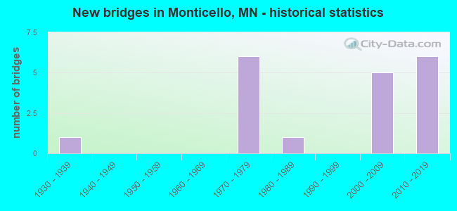
- New bridges - historical statistics
- 11930-1939
- 61970-1979
- 11980-1989
- 52000-2009
- 62010-2019
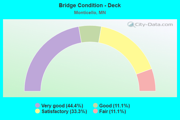
- Bridge Condition - Deck
- 44.4%Very good
- 11.1%Good
- 33.3%Satisfactory
- 11.1%Fair
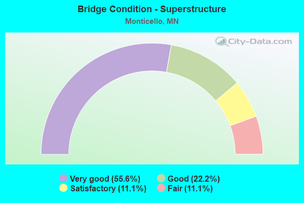
- Bridge Condition - Superstructure
- 55.6%Very good
- 22.2%Good
- 11.1%Satisfactory
- 11.1%Fair
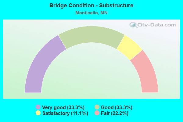
- Bridge Condition - Substructure
- 33.3%Very good
- 33.3%Good
- 11.1%Satisfactory
- 22.2%Fair
Find on map >> Show street view
Structure Number: 6274, Location: 1.3 MI NW OF JCT TH 25 (Lat: 45.313767, Lng: -93.817925), Route carried "on" structure: County highway 75, Year Built: 1936, Status: Open, Structure Length: 0.79m (2.59ft), Average Daily Traffic: 5,300 (year 2016), Average Future Daily Traffic: 5,300 (year 2039), Design Load: H 15, Features Intersected: OTTER CREEK
Minimum Vertical Clearance: 30+ m (98+ ft), Kilometerpoint: 0.000, Lanes on structure: 2, Owner: County Highway Agency, Approaching Roadway Width: 12.8m (42.0ft), Skew: 3 degrees, Material/Design: Concrete, Design/Construction: Culvert, Number Of Spans In Main Unit: 2, Length of Maximum Span: 3.6m (11.8ft)
Condition: Channel: Good, Culverts: Satisfactory, Operating Rating: 53.9 metric tons, Method Used To Determine Operating Rating: Assigned ratings based on Allowable Stress Design (ASD) reported in metric tons, Inventory Rating: 35.9 metric tons, Method Used To Determine Inventory Rating: Assigned ratings based on Allowable Stress Design (ASD) reported in metric tons, Structural Evaluation: Equal to present minimum criteria, Waterway Adequacy: Better than present minimum criteria, Approach Roadway Alignment: Equal to present desirable criteria, Designated Inspection Frequency: Every 24 months, Inspection Date: November 2020
Find on map >> Show street view
Structure Number: 71012, Location: 0.7 MI N OF JCT TH 94 (Lat: 45.308761, Lng: -93.791039), Route carried "on" structure: State highway 25, Year Built: 1987, Status: Open, Structure Length: 30.64m (100.52ft), Average Daily Traffic: 39,035 (year 2019), Truck Traffic: 7%, Average Future Daily Traffic: 36,500 (year 2039), Design Load: HS 20, Features Intersected: MISSISSIPPI RIVER
Minimum Vertical Clearance: 30+ m (98+ ft), Kilometerpoint: 0.000, Lanes on structure: 4, Base Highway Network: Yes, Owner: State Highway Agency, Approaching Roadway Width: 18.9m (62.0ft), Skew: 21 degrees, Material/Design: Prestressed concrete, Design/Construction: Stringer/Multi-beam, Number Of Spans In Main Unit: 9, Length of Maximum Span: 33.9m (111.2ft), Curb or Sidewalk Widths: Left: 1.8m (5.9ft), Right: 1.8m (5.9ft), Curb-To-Curb Width: 17.1m (56.1ft), Out-to-Out Width: 23.3m (76.4ft)
Condition: Deck: Satisfactory, Superstructure: Satisfactory, Substructure: Satisfactory, Channel: Good, Operating Rating: 56.1 metric tons, Method Used To Determine Operating Rating: Load Factor (LF), Inventory Rating: 39.5 metric tons, Method Used To Determine Inventory Rating: Load Factor (LF), Structural Evaluation: Equal to present minimum criteria, Deck Geometry: Somewhat better than minimum adequacy, Waterway Adequacy: Equal to present desirable criteria, Approach Roadway Alignment: Equal to present desirable criteria, Designated Inspection Frequency: Every 24 months, Underwater Inspection Frequency: Every 60 months, Inspection Date: October 2021, Underwater Inspection Date: September 2021, Deck Structure Type: Concrete Cast-file-Place, Wearing Surface/Protective System: Wearing Surface: Monolithic Concrete, Deck Protection: Epoxy Coated Reinforcing
Find on map >> Show street view
Structure Number: 86526, Location: 59 W of jct CSAH 18 (Lat: 45.290975, Lng: -93.771019), Route carried "on" structure: , Year Built: 2001, Status: Open, Structure Length: 9.62m (31.56ft), Features Intersected: I 94, Facility Carried by Structure: PEDESTRIAN
Lanes under structure: 4, Owner: City or Municipal Highway Agency, Skew: 2 degrees, Material/Design: Prestressed concrete, Design/Construction: Stringer/Multi-beam, Number Of Spans In Main Unit: 2, Length of Maximum Span: 47.2m (154.9ft), Out-to-Out Width: 4.3m (14.1ft)
Condition: Deck: Very good, Superstructure: Very good, Substructure: Good, Underclear: Better than present minimum criteria, Bridge Posting: Required (Relationship of Operating Rating to Maximum Legal Load: > 39.9% below), Designated Inspection Frequency: Every 24 months, Inspection Date: July 2021, Deck Structure Type: Concrete Cast-file-Place, Wearing Surface/Protective System: Wearing Surface: Monolithic Concrete, Deck Protection: Epoxy Coated Reinforcing
Find on map >> Show street view
Structure Number: 8653, Location: 1.5 MI E OF JCT TH 25 (Lat: 45.290806, Lng: -93.770539), Route carried "on" structure: County highway 18, Year Built: 2005, Status: Open, Structure Length: 8.28m (27.17ft), Average Daily Traffic: 12,000 (year 2016), Average Future Daily Traffic: 12,000 (year 2039), Design Load: HL 93, Features Intersected: I 94
Minimum Vertical Clearance: 30+ m (98+ ft), Kilometerpoint: 0.000, Lanes on structure: 4, Lanes under structure: 5, Owner: State Highway Agency, Approaching Roadway Width: 25.0m (82.0ft), Skew: 22 degrees, Material/Design: Prestressed concrete, Design/Construction: Stringer/Multi-beam, Number Of Spans In Main Unit: 2, Length of Maximum Span: 40.5m (132.9ft), Curb-To-Curb Width: 25.0m (82.0ft), Out-to-Out Width: 33.4m (109.6ft)
Condition: Deck: Very good, Superstructure: Very good, Substructure: Very good, Operating Rating: 72.2 metric tons, Method Used To Determine Operating Rating: Load Factor (LF), Inventory Rating: 47.0 metric tons, Method Used To Determine Inventory Rating: Load Factor (LF), Structural Evaluation: Equal to present desirable criteria, Deck Geometry: Superior to present desirable criteria, Underclear: Somewhat better than minimum adequacy, Approach Roadway Alignment: Equal to present desirable criteria, Length Of Structure Improvement: 2.77m (9.09ft), Designated Inspection Frequency: Every 24 months, Inspection Date: July 2021, Bridge Improvement Cost: $999,999,000, Roadway Improvement Cost: $1,000, Total Project Cost: $1,000, Deck Structure Type: Concrete Cast-file-Place, Wearing Surface/Protective System: Wearing Surface: Low Slump Concrete, Deck Protection: Epoxy Coated Reinforcing
Find on map >> Show street view
Structure Number: 86802, Location: 1.1 MI W OF JCT TH 25 (Lat: 45.306564, Lng: -93.819694), Route carried "on" structure: County highway 39, Year Built: 1971, Status: Open, Structure Length: 11.38m (37.34ft), Average Daily Traffic: 3,100 (year 2016), Average Future Daily Traffic: 3,100 (year 2039), Design Load: HS 20, Features Intersected: I 94
Minimum Vertical Clearance: 30+ m (98+ ft), Kilometerpoint: 0.000, Lanes on structure: 2, Lanes under structure: 4, Owner: State Highway Agency, Approaching Roadway Width: 13.4m (44.0ft), Skew: 4 degrees, Material/Design: Steel continuous, Design/Construction: Stringer/Multi-beam, Number Of Spans In Main Unit: 4, Length of Maximum Span: 35.1m (115.2ft), Curb-To-Curb Width: 13.4m (44.0ft), Out-to-Out Width: 14.4m (47.2ft)
Condition: Deck: Satisfactory, Superstructure: Good, Substructure: Fair, Operating Rating: 60.2 metric tons, Method Used To Determine Operating Rating: Load Factor (LF), Inventory Rating: 36.1 metric tons, Method Used To Determine Inventory Rating: Load Factor (LF), Structural Evaluation: Somewhat better than minimum adequacy, Deck Geometry: Better than present minimum criteria, Underclear: Somewhat better than minimum adequacy, Approach Roadway Alignment: Equal to present desirable criteria, Designated Inspection Frequency: Every 24 months, Inspection Date: July 2020, Deck Structure Type: Concrete Cast-file-Place, Wearing Surface/Protective System: Wearing Surface: Low Slump Concrete, Deck Protection: Epoxy Coated Reinforcing
Find on map >> Show street view
Structure Number: 86803, Location: AT JCT TH 25; 94 (Lat: 45.298492, Lng: -93.799308), Route carried "on" structure: State highway 25, Year Built: 1972, Year Reconstructed: 1989, Status: Open, Structure Length: 8.71m (28.58ft), Average Daily Traffic: 29,026 (year 2019), Truck Traffic: 6%, Average Future Daily Traffic: 28,500 (year 2039), Design Load: HS 20, Features Intersected: I 94
Minimum Vertical Clearance: 30+ m (98+ ft), Kilometerpoint: 0.000, Lanes on structure: 2, Lanes under structure: 4, Base Highway Network: Yes, Owner: State Highway Agency, Approaching Roadway Width: 21.9m (71.9ft), Skew: 21 degrees, Material/Design: Prestressed concrete, Design/Construction: Stringer/Multi-beam, Number Of Spans In Main Unit: 4, Length of Maximum Span: 26.7m (87.6ft), Curb or Sidewalk Widths: Left: 1.8m (5.9ft), Right: 1.8m (5.9ft), Curb-To-Curb Width: 20.1m (65.9ft), Out-to-Out Width: 26.3m (86.3ft)
Condition: Deck: Fair, Superstructure: Fair, Substructure: Good, Operating Rating: 53.9 metric tons, Method Used To Determine Operating Rating: Load Factor (LF), Inventory Rating: 31.7 metric tons, Method Used To Determine Inventory Rating: Load Factor (LF), Structural Evaluation: Somewhat better than minimum adequacy, Deck Geometry: Superior to present desirable criteria, Underclear: Somewhat better than minimum adequacy, Approach Roadway Alignment: Equal to present desirable criteria, Designated Inspection Frequency: Every 24 months, Inspection Date: July 2021, Deck Structure Type: Concrete Cast-file-Place, Wearing Surface/Protective System: Wearing Surface: Low Slump Concrete, Deck Protection: Epoxy Coated Reinforcing
Find on map >> Show street view
Structure Number: 86815, Location: 3.0 MI W OF JCT TH 25 (Lat: 45.325253, Lng: -93.847717), Route carried "on" structure: County highway 209, Year Built: 1971, Status: Open, Structure Length: 9.51m (31.20ft), Average Daily Traffic: 1,700 (year 1992), Average Future Daily Traffic: 1,700 (year 2029), Design Load: H 20, Features Intersected: I 94
Minimum Vertical Clearance: 30+ m (98+ ft), Kilometerpoint: 0.000, Lanes on structure: 2, Lanes under structure: 4, Owner: State Highway Agency, Approaching Roadway Width: 11.3m (37.1ft), Skew: 2 degrees, Material/Design: Prestressed concrete, Design/Construction: Stringer/Multi-beam, Number Of Spans In Main Unit: 4, Length of Maximum Span: 29.1m (95.5ft), Curb-To-Curb Width: 9.8m (32.2ft), Out-to-Out Width: 11.0m (36.1ft)
Condition: Deck: Satisfactory, Superstructure: Good, Substructure: Fair, Operating Rating: 51.4 metric tons, Method Used To Determine Operating Rating: Load Factor (LF), Inventory Rating: 23.7 metric tons, Method Used To Determine Inventory Rating: Load Factor (LF), Structural Evaluation: Somewhat better than minimum adequacy, Deck Geometry: Somewhat better than minimum adequacy, Underclear: Equal to present minimum criteria, Approach Roadway Alignment: Somewhat better than minimum adequacy, Designated Inspection Frequency: Every 24 months, Inspection Date: July 2020, Deck Structure Type: Concrete Cast-file-Place, Wearing Surface/Protective System: Wearing Surface: Monolithic Concrete
Find on map >> Show street view
Structure Number: 86819, Location: 1.9 MI E OF JCT TH 25 (Lat: 45.289875, Lng: -93.762253), Route carried "on" structure: Interstate 94, Year Built: 2010, Status: Open, Structure Length: 7.80m (25.59ft), Average Daily Traffic: 30,000 (year 2016), Average Future Daily Traffic: 30,000 (year 2039), Design Load: HL 93, Features Intersected: BROADWAY; BNSF RR
Minimum Vertical Clearance: 30+ m (98+ ft), Kilometerpoint: 0.000, Lanes on structure: 3, Lanes under structure: 2, Base Highway Network: Yes, Owner: State Highway Agency, Approaching Roadway Width: 14.0m (45.9ft), Skew: 5 degrees, Material/Design: Prestressed concrete, Design/Construction: Stringer/Multi-beam, Number Of Spans In Main Unit: 2, Length of Maximum Span: 47.5m (155.8ft), Curb-To-Curb Width: 15.2m (49.9ft), Out-to-Out Width: 16.2m (53.1ft)
Condition: Deck: Good, Superstructure: Very good, Substructure: Very good, Operating Rating: 76.6 metric tons, Method Used To Determine Operating Rating: Load Factor (LF), Inventory Rating: 33.3 metric tons, Method Used To Determine Inventory Rating: Load Factor (LF), Structural Evaluation: Equal to present desirable criteria, Deck Geometry: Meets minimum limits, Underclear: Superior to present desirable criteria, Approach Roadway Alignment: Equal to present desirable criteria, Designated Inspection Frequency: Every 24 months, Inspection Date: July 2021, Deck Structure Type: Concrete Cast-file-Place, Wearing Surface/Protective System: Wearing Surface: Low Slump Concrete, Deck Protection: Epoxy Coated Reinforcing
Find on map >> Show street view
Structure Number: 8682, Location: 1.9 MI E OF JCT TH 25 (Lat: 45.289378, Lng: -93.761878), Route carried "on" structure: Interstate 94, Year Built: 2010, Status: Open, Structure Length: 7.92m (25.98ft), Average Daily Traffic: 31,000 (year 2019), Truck Traffic: 12%, Average Future Daily Traffic: 30,000 (year 2039), Design Load: HL 93, Features Intersected: BROADWAY ST; BNSF RR
Minimum Vertical Clearance: 30+ m (98+ ft), Kilometerpoint: 0.000, Lanes on structure: 2, Lanes under structure: 2, Base Highway Network: Yes, Owner: State Highway Agency, Approaching Roadway Width: 14.0m (45.9ft), Skew: 5 degrees, Material/Design: Prestressed concrete, Design/Construction: Stringer/Multi-beam, Number Of Spans In Main Unit: 2, Length of Maximum Span: 48.6m (159.4ft), Curb-To-Curb Width: 17.1m (56.1ft), Out-to-Out Width: 18.1m (59.4ft)
Condition: Deck: Very good, Superstructure: Very good, Substructure: Good, Operating Rating: 53.5 metric tons, Method Used To Determine Operating Rating: Load and Resistance Factor Rating (LRFR) rating reported by rating factor(RF) method using HL-93 loadings, Inventory Rating: 34.7 metric tons, Method Used To Determine Inventory Rating: Load and Resistance Factor Rating (LRFR) rating reported by rating factor(RF) method using HL-93 loadings, Structural Evaluation: Better than present minimum criteria, Deck Geometry: Superior to present desirable criteria, Underclear: Superior to present desirable criteria, Approach Roadway Alignment: Equal to present desirable criteria, Designated Inspection Frequency: Every 24 months, Inspection Date: July 2021, Deck Structure Type: Concrete Cast-file-Place, Wearing Surface/Protective System: Wearing Surface: Low Slump Concrete, Deck Protection: Epoxy Coated Reinforcing
Find on map >> Show street view
Structure Number: 86821, Location: 0.75 MI SE OF TH 25 (Lat: 45.295494, Lng: -93.784614), Route carried "on" structure: City street 104, Year Built: 2018, Status: Open, Structure Length: 6.10m (20.01ft), Average Daily Traffic: 1,750 (year 2012), Average Future Daily Traffic: 11,000 (year 2038), Design Load: HL 93, Features Intersected: I 94
Minimum Vertical Clearance: 30+ m (98+ ft), Kilometerpoint: 0.000, Lanes on structure: 2, Lanes under structure: 5, Owner: State Highway Agency, Maintenance Responsibility: City or Municipal Highway Agency, Approaching Roadway Width: 14.4m (47.2ft), Skew: 2 degrees, Material/Design: Prestressed concrete, Design/Construction: Stringer/Multi-beam, Number Of Spans In Main Unit: 2, Length of Maximum Span: 32.0m (105.0ft), Curb or Sidewalk Widths: Left: 0.0m, Right: 3.7m (12.1ft), Curb-To-Curb Width: 10.4m (34.1ft), Out-to-Out Width: 15.3m (50.2ft)
Condition: Deck: Very good, Superstructure: Very good, Substructure: Very good, Operating Rating: 73.2 metric tons, Method Used To Determine Operating Rating: Load and Resistance Factor Rating (LRFR) rating reported by rating factor(RF) method using HL-93 loadings, Inventory Rating: 56.7 metric tons, Method Used To Determine Inventory Rating: Load and Resistance Factor Rating (LRFR) rating reported by rating factor(RF) method using HL-93 loadings, Structural Evaluation: Equal to present desirable criteria, Deck Geometry: Equal to present minimum criteria, Underclear: Equal to present minimum criteria, Approach Roadway Alignment: Equal to present desirable criteria, Designated Inspection Frequency: Every 24 months, Inspection Date: October 2020, Deck Structure Type: Concrete Cast-file-Place, Wearing Surface/Protective System: Wearing Surface: Monolithic Concrete, Deck Protection: Epoxy Coated Reinforcing
Find on map >> Show street view
Structure Number: 86526, Location: 59 W of jct CSAH 18 (Lat: 45.290975, Lng: -93.771019), Route carried "under" structure: Interstate 94, Year Built: 2001, Structure Length: 0. m, Average Daily Traffic: 32,000 (year 2019), Truck Traffic: 15%, Features Intersected: I 94, Facility Carried by Structure: PEDESTRIAN
Minimum Vertical Clearance: 5.61m (18.41ft), Kilometerpoint: 0.000, Lanes on structure: 4, Lanes under structure: 4, Material/Design: Prestressed concrete, Design/Construction: Stringer/Multi-beam, Length of Maximum Span: 47.2m (154.9ft)
Find on map >> Show street view
Structure Number: 8653, Location: 1.5 MI E OF JCT TH 25 (Lat: 45.290806, Lng: -93.770539), Route carried "under" structure: Interstate 94, Year Built: 2005, Structure Length: 0. m, Average Daily Traffic: 32,000 (year 2019), Truck Traffic: 15%, Features Intersected: I 94, Facility Carried by Structure: CSAH 18
Minimum Vertical Clearance: 5.00m (16.40ft), Kilometerpoint: 0.000, Lanes on structure: 4, Lanes under structure: 4, Material/Design: Prestressed concrete, Design/Construction: Stringer/Multi-beam, Length of Maximum Span: 40.5m (132.9ft)
Find on map >> Show street view
Structure Number: 8653, Location: 1.5 MI E OF JCT TH 25 (Lat: 45.290806, Lng: -93.770539), Route carried "under" structure: Ramp Interstate 676, Year Built: 2005, Structure Length: 0. m, Average Daily Traffic: 1 (year 2019), Truck Traffic: 13%, Features Intersected: I 94, Facility Carried by Structure: CSAH 18
Minimum Vertical Clearance: 4.88m (16.01ft), Kilometerpoint: 0.000, Lanes under structure: 1, Material/Design: Prestressed concrete, Design/Construction: Stringer/Multi-beam, Length of Maximum Span: 40.5m (132.9ft)
Find on map >> Show street view
Structure Number: 86802, Location: 1.1 MI W OF JCT TH 25 (Lat: 45.306564, Lng: -93.819694), Route carried "under" structure: Interstate 94, Year Built: 1971, Structure Length: 0. m, Average Daily Traffic: 45,500 (year 2019), Truck Traffic: 15%, Features Intersected: I 94, Facility Carried by Structure: CSAH 39
Minimum Vertical Clearance: 5.06m (16.60ft), Kilometerpoint: 0.000, Lanes on structure: 2, Lanes under structure: 4, Material/Design: Steel continuous, Design/Construction: Stringer/Multi-beam, Length of Maximum Span: 35.1m (115.2ft)
Find on map >> Show street view
Structure Number: 86803, Location: AT JCT TH 25; 94 (Lat: 45.298492, Lng: -93.799308), Route carried "under" structure: Interstate 94, Year Built: 1972, Structure Length: 0. m, Average Daily Traffic: 32,000 (year 2019), Truck Traffic: 15%, Features Intersected: I 94, Facility Carried by Structure: MN 25
Minimum Vertical Clearance: 4.94m (16.21ft), Kilometerpoint: 0.000, Lanes on structure: 2, Lanes under structure: 4, Material/Design: Prestressed concrete, Design/Construction: Stringer/Multi-beam, Length of Maximum Span: 26.7m (87.6ft)
Find on map >> Show street view
Structure Number: 86815, Location: 3.0 MI W OF JCT TH 25 (Lat: 45.325253, Lng: -93.847717), Route carried "under" structure: Interstate 94, Year Built: 1971, Structure Length: 0. m, Average Daily Traffic: 45,500 (year 2019), Truck Traffic: 15%, Features Intersected: I 94, Facility Carried by Structure: T 209
Minimum Vertical Clearance: 5.55m (18.21ft), Kilometerpoint: 0.000, Lanes on structure: 2, Lanes under structure: 4, Material/Design: Prestressed concrete, Design/Construction: Stringer/Multi-beam, Length of Maximum Span: 29.1m (95.5ft)
Find on map >> Show street view
Structure Number: 86819, Location: 1.9 MI E OF JCT TH 25 (Lat: 45.289875, Lng: -93.762253), Route carried "under" structure: City street 118, Year Built: 2010, Structure Length: 0. m, Average Daily Traffic: 6,200 (year 2004), Features Intersected: BROADWAY; BNSF RR, Facility Carried by Structure: I 94
Minimum Vertical Clearance: 5.58m (18.31ft), Kilometerpoint: 0.000, Lanes under structure: 2, Material/Design: Prestressed concrete, Design/Construction: Stringer/Multi-beam, Length of Maximum Span: 47.5m (155.8ft)
Find on map >> Show street view
Structure Number: 8682, Location: 1.9 MI E OF JCT TH 25 (Lat: 45.289378, Lng: -93.761878), Route carried "under" structure: City street 118, Year Built: 2010, Structure Length: 0. m, Average Daily Traffic: 2,050 (year 2008), Features Intersected: BROADWAY ST; BNSF RR, Facility Carried by Structure: I 94
Minimum Vertical Clearance: 5.40m (17.72ft), Kilometerpoint: 0.000, Lanes on structure: 2, Lanes under structure: 2, Material/Design: Prestressed concrete, Design/Construction: Stringer/Multi-beam, Length of Maximum Span: 48.6m (159.4ft)
Find on map >> Show street view
Structure Number: 86821, Location: 0.75 MI SE OF TH 25 (Lat: 45.295494, Lng: -93.784614), Route carried "under" structure: Interstate 94, Year Built: 2018, Structure Length: 0. m, Average Daily Traffic: 32,000 (year 2019), Truck Traffic: 15%, Features Intersected: I 94, Facility Carried by Structure: MSAS 104
Minimum Vertical Clearance: 5.27m (17.29ft), Kilometerpoint: 0.000, Lanes under structure: 5, Material/Design: Prestressed concrete, Design/Construction: Stringer/Multi-beam, Length of Maximum Span: 32.0m (105.0ft)