Bridge Statistics for Montezuma, Indiana (IN)
Condition, Traffic, Stress, Structural Evaluation, Project Costs
- National Bridge Inventory (NBI) Statistics
- 19Number of bridges
- 285ft / 86.8mTotal length
- $4,563,000Total costs
- 20,823Total average daily traffic
- 3,420Total average daily truck traffic
- National Bridge Inventory (NBI) Registered Bridges for Montezuma
- No street view available for this location
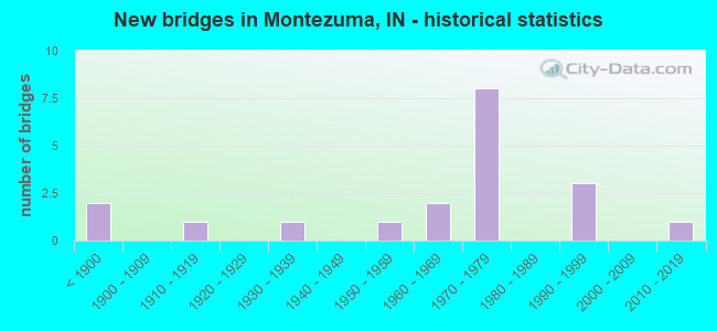
- New bridges - historical statistics
- 2Before 1900
- 11910-1919
- 11930-1939
- 11950-1959
- 21960-1969
- 81970-1979
- 31990-1999
- 12010-2019

- Reconstructed bridges - Historical Statistics
- 21970-1979
- 31980-1989
- 01990-1999
- 12000-2009
- 22010-2019


- Bridge Condition - Deck
- 13.3%Very good
- 46.7%Good
- 33.3%Satisfactory
- 6.7%Fair

- Bridge Condition - Superstructure
- 6.7%Very good
- 33.3%Good
- 53.3%Satisfactory
- 6.7%Poor

- Bridge Condition - Substructure
- 13.3%Very good
- 33.3%Good
- 33.3%Satisfactory
- 13.3%Fair
- 6.7%Poor

- Bridge Condition - Channel
- 20.0%Very good
- 26.7%Good
- 40.0%Satisfactory
- 13.3%Fair
Find on map >> Show street view
Structure Number: 115, Location: 04.70 E SR 63 (Lat: 39.775889, Lng: -87.329811), Route carried "on" structure: US 36, Year Built: 1976, Year Reconstructed: 2016, Status: Open, Structure Length: 5.30m (17.39ft), Average Daily Traffic: 2,880 (year 2015), Truck Traffic: 14%, Average Future Daily Traffic: 2,880 (year 2025), Design Load: HS 20, Features Intersected: LEATHERWOOD CREEK
Minimum Vertical Clearance: 30+ m (98+ ft), Kilometerpoint: 4.715, Lanes on structure: 2, Base Highway Network: Yes (, Subroute: 1), Owner: State Highway Agency, Approaching Roadway Width: 13.4m (44.0ft), Skew: 3 degrees, Material/Design: Prestressed concrete continuous, Design/Construction: Stringer/Multi-beam, Number Of Spans In Main Unit: 3, Length of Maximum Span: 17.4m (57.1ft), Curb-To-Curb Width: 13.3m (43.6ft), Out-to-Out Width: 14.2m (46.6ft)
Condition: Deck: Good, Superstructure: Satisfactory, Substructure: Good, Channel: Very good, Operating Rating: 59.3 metric tons, Method Used To Determine Operating Rating: Load and Resistance Factor Rating (LRFR) rating reported by rating factor(RF) method using HL-93 loadings, Inventory Rating: 43.4 metric tons, Method Used To Determine Inventory Rating: Load and Resistance Factor Rating (LRFR) rating reported by rating factor(RF) method using HL-93 loadings, Structural Evaluation: Equal to present minimum criteria, Deck Geometry: Equal to present minimum criteria, Waterway Adequacy: Superior to present desirable criteria, Approach Roadway Alignment: Equal to present desirable criteria, Designated Inspection Frequency: Every 24 months, Inspection Date: March 2022, Deck Structure Type: Concrete Cast-file-Place, Wearing Surface/Protective System: Wearing Surface: Latex Concrete
Find on map >> Show street view
Structure Number: 2267, Location: 08.25 S SR 71 (Lat: 39.792811, Lng: -87.408631), Route carried "on" structure: State highway 63, Year Built: 1974, Year Reconstructed: 1993, Status: Open, Structure Length: 18.75m (61.52ft), Average Daily Traffic: 3,139 (year 2020), Truck Traffic: 24%, Average Future Daily Traffic: 5,785 (year 2033), Design Load: HS 20, Features Intersected: US 36, LTL RACCOON CR, R
Minimum Vertical Clearance: 30+ m (98+ ft), Kilometerpoint: 21.742, Lanes on structure: 3, Lanes under structure: 4, Base Highway Network: Yes (, Subroute: 1), Owner: State Highway Agency, Approaching Roadway Width: 11.6m (38.1ft), Skew: 1 degrees, Material/Design: Steel continuous, Design/Construction: Stringer/Multi-beam, Number Of Spans In Main Unit: 1, Number Of Approach Spans: 8, Length of Maximum Span: 42.7m (140.1ft), Curb-To-Curb Width: 14.8m (48.6ft), Out-to-Out Width: 15.7m (51.5ft)
Condition: Deck: Good, Superstructure: Good, Substructure: Fair, Channel: Satisfactory, Operating Rating: 39.5 metric tons, Method Used To Determine Operating Rating: Load and Resistance Factor Rating (LRFR) rating reported by rating factor(RF) method using HL-93 loadings, Inventory Rating: 30.5 metric tons, Method Used To Determine Inventory Rating: Load and Resistance Factor Rating (LRFR) rating reported by rating factor(RF) method using HL-93 loadings, Structural Evaluation: Somewhat better than minimum adequacy, Deck Geometry: Equal to present minimum criteria, Underclear: Better than present minimum criteria, Waterway Adequacy: Superior to present desirable criteria, Approach Roadway Alignment: Equal to present desirable criteria, Designated Inspection Frequency: Every 24 months, Other Special Inspection Frequency: Every 48 months, Inspection Date: August 2021, Other Special Inspection Date: July 2019, Deck Structure Type: Concrete Cast-file-Place, Wearing Surface/Protective System: Wearing Surface: Latex Concrete
Find on map >> Show street view
Structure Number: 2268, Location: 08.25 S SR 71 (Lat: 39.793661, Lng: -87.408919), Route carried "on" structure: State highway 63, Year Built: 1974, Year Reconstructed: 1993, Status: Open, Structure Length: 18.75m (61.52ft), Average Daily Traffic: 3,177 (year 2020), Truck Traffic: 24%, Average Future Daily Traffic: 5,785 (year 2033), Design Load: HS 20, Features Intersected: US 36, LTL RACCOON CR, R
Minimum Vertical Clearance: 30+ m (98+ ft), Kilometerpoint: 21.742, Lanes on structure: 2, Lanes under structure: 4, Base Highway Network: Yes (, Subroute: 1), Owner: State Highway Agency, Approaching Roadway Width: 11.6m (38.1ft), Skew: 1 degrees, Material/Design: Steel continuous, Design/Construction: Stringer/Multi-beam, Number Of Spans In Main Unit: 1, Number Of Approach Spans: 8, Length of Maximum Span: 42.7m (140.1ft), Curb-To-Curb Width: 12.1m (39.7ft), Out-to-Out Width: 13.1m (43.0ft)
Condition: Deck: Good, Superstructure: Satisfactory, Substructure: Satisfactory, Channel: Good, Operating Rating: 36.6 metric tons, Method Used To Determine Operating Rating: Load and Resistance Factor Rating (LRFR) rating reported by rating factor(RF) method using HL-93 loadings, Inventory Rating: 28.2 metric tons, Method Used To Determine Inventory Rating: Load and Resistance Factor Rating (LRFR) rating reported by rating factor(RF) method using HL-93 loadings, Structural Evaluation: Equal to present minimum criteria, Deck Geometry: Better than present minimum criteria, Underclear: Better than present minimum criteria, Waterway Adequacy: Superior to present desirable criteria, Approach Roadway Alignment: Equal to present desirable criteria, Designated Inspection Frequency: Every 24 months, Other Special Inspection Frequency: Every 48 months, Inspection Date: August 2021, Other Special Inspection Date: July 2019, Deck Structure Type: Concrete Cast-file-Place, Wearing Surface/Protective System: Wearing Surface: Latex Concrete
Find on map >> Show street view
Structure Number: 22685, Location: 00.05 N US 36 (Lat: 39.794950, Lng: -87.410789), Route carried "on" structure: Ramp State highway 63, Year Built: 1968, Year Reconstructed: 2018, Status: Open, Structure Length: 4.21m (13.81ft), Average Daily Traffic: 1,580 (year 2006), Truck Traffic: 27%, Average Future Daily Traffic: 2,188 (year 2034), Design Load: HS 20, Features Intersected: LITTLE RACCOON CREEK
Minimum Vertical Clearance: 30+ m (98+ ft), Kilometerpoint: 22.370, Lanes on structure: 2, Base Highway Network: Yes (, Subroute: 1), Owner: State Highway Agency, Approaching Roadway Width: 16.2m (53.1ft), Skew: 23 degrees, Material/Design: Prestressed concrete continuous, Design/Construction: Stringer/Multi-beam, Number Of Spans In Main Unit: 3, Length of Maximum Span: 14.0m (45.9ft), Curb-To-Curb Width: 15.7m (51.5ft), Out-to-Out Width: 16.8m (55.1ft)
Condition: Deck: Good, Superstructure: Good, Substructure: Good, Channel: Good, Operating Rating: 64.7 metric tons, Method Used To Determine Operating Rating: Load Factor (LF), Inventory Rating: 36.8 metric tons, Method Used To Determine Inventory Rating: Load Factor (LF), Structural Evaluation: Better than present minimum criteria, Deck Geometry: Superior to present desirable criteria, Waterway Adequacy: Better than present minimum criteria, Approach Roadway Alignment: Equal to present desirable criteria, Designated Inspection Frequency: Every 24 months, Inspection Date: June 2020, Deck Structure Type: Concrete Cast-file-Place, Wearing Surface/Protective System: Wearing Surface: Latex Concrete
Find on map >> Show street view
Structure Number: 610006, Location: 00.30 S of US 36 (Lat: 39.773531, Lng: -87.331200), Route carried "on" structure: County highway 44, Year Built: 1883, Year Reconstructed: 1977, Status: Posted for load, Structure Length: 3.10m (10.17ft), Average Daily Traffic: 103 (year 2018), Truck Traffic: 5%, Average Future Daily Traffic: 122 (year 2038), Features Intersected: LEATHERWOOD Creek, Facility Carried by Structure: CR 40N
Minimum Vertical Clearance: 3.81m (12.50ft), Kilometerpoint: 0.000, Lanes on structure: 1, Owner: County Highway Agency, Approaching Roadway Width: 6.1m (20.0ft), Material/Design: Wood or Timber, Design/Construction: Truss - Thru, Number Of Spans In Main Unit: 1, Length of Maximum Span: 24.5m (80.4ft), Curb-To-Curb Width: 4.5m (14.8ft), Out-to-Out Width: 4.9m (16.1ft)
Condition: Deck: Satisfactory, Superstructure: Poor, Substructure: Satisfactory, Channel: Satisfactory, Operating Rating: 16.3 metric tons, Method Used To Determine Operating Rating: Allowable Stress (AS), Inventory Rating: 11.8 metric tons, Method Used To Determine Inventory Rating: Allowable Stress (AS), Structural Evaluation: Meets minimum limits, Deck Geometry: High priority of replacement, Waterway Adequacy: Better than present minimum criteria, Approach Roadway Alignment: High priority of corrective action, Bridge Posting: Required (Relationship of Operating Rating to Maximum Legal Load: > 39.9% below), Length Of Structure Improvement: 3.11m (10.20ft), Designated Inspection Frequency: Every 12 months, Inspection Date: April 2021, Bridge Improvement Cost: $89,000, Roadway Improvement Cost: $5,000, Total Project Cost: $115,000 ( Estimate for 2020), Deck Structure Type: Wood or Timber, Wearing Surface/Protective System: Wearing Surface: Wood or Timber
Find on map >> Show street view
Structure Number: 610014, Location: 00.90 E of CR 600W (Lat: 39.789111, Lng: -87.335111), Route carried "on" structure: County highway , Year Built: 1896, Year Reconstructed: 1977, Status: Posted for load, Structure Length: 2.98m (9.78ft), Average Daily Traffic: 206 (year 2018), Truck Traffic: 5%, Average Future Daily Traffic: 244 (year 2038), Features Intersected: LEATHERWOOD Creek, Facility Carried by Structure: STRAWBERRY Rd
Minimum Vertical Clearance: 3.66m (12.01ft), Kilometerpoint: 0.000, Lanes on structure: 1, Owner: County Highway Agency, Approaching Roadway Width: 7.6m (24.9ft), Material/Design: Wood or Timber, Design/Construction: Truss - Thru, Number Of Spans In Main Unit: 1, Length of Maximum Span: 24.6m (80.7ft), Curb-To-Curb Width: 4.4m (14.4ft), Out-to-Out Width: 4.9m (16.1ft)
Condition: Deck: Fair, Superstructure: Satisfactory, Substructure: Fair, Channel: Fair, Operating Rating: 14.1 metric tons, Method Used To Determine Operating Rating: Allowable Stress (AS), Inventory Rating: 10.5 metric tons, Method Used To Determine Inventory Rating: Allowable Stress (AS), Structural Evaluation: High priority of corrective action, Deck Geometry: High priority of replacement, Waterway Adequacy: Better than present minimum criteria, Approach Roadway Alignment: Equal to present minimum criteria, Bridge Posting: Required (Relationship of Operating Rating to Maximum Legal Load: > 39.9% below), Length Of Structure Improvement: 2.99m (9.81ft), Designated Inspection Frequency: Every 24 months, Inspection Date: April 2020, Bridge Improvement Cost: $41,000, Roadway Improvement Cost: $5,000, Total Project Cost: $56,000 ( Estimate for 2020), Deck Structure Type: Wood or Timber, Wearing Surface/Protective System: Wearing Surface: Wood or Timber
Find on map >> Show street view
Structure Number: 6100144, Location: 00.10 E of CR 450 W (Lat: 39.798781, Lng: -87.328031), Route carried "on" structure: County highway , Year Built: 1959, Status: Open, Structure Length: 3.70m (12.14ft), Average Daily Traffic: 227 (year 2018), Truck Traffic: 4%, Average Future Daily Traffic: 270 (year 2038), Design Load: HS 20, Features Intersected: LEATHERWOOD Creek, Facility Carried by Structure: LEATHERWOOD Rd
Minimum Vertical Clearance: 30+ m (98+ ft), Kilometerpoint: 0.000, Lanes on structure: 2, Owner: County Highway Agency, Approaching Roadway Width: 5.8m (19.0ft), Skew: 1 degrees, Material/Design: Concrete continuous, Design/Construction: Slab, Number Of Spans In Main Unit: 3, Length of Maximum Span: 14.5m (47.6ft), Curb or Sidewalk Widths: Left: 0.3m (1.0ft), Right: 0.3m (1.0ft), Curb-To-Curb Width: 6.7m (22.0ft), Out-to-Out Width: 7.3m (24.0ft)
Condition: Deck: Satisfactory, Superstructure: Satisfactory, Substructure: Poor, Channel: Fair, Operating Rating: 57.0 metric tons, Method Used To Determine Operating Rating: Load Factor (LF), Inventory Rating: 34.1 metric tons, Method Used To Determine Inventory Rating: Load Factor (LF), Structural Evaluation: Meets minimum limits, Deck Geometry: Meets minimum limits, Waterway Adequacy: Equal to present minimum criteria, Approach Roadway Alignment: Equal to present minimum criteria, Designated Inspection Frequency: Every 12 months, Inspection Date: April 2021, Deck Structure Type: Concrete Cast-file-Place, Wearing Surface/Protective System: Wearing Surface: Monolithic Concrete
Find on map >> Show street view
Structure Number: 610024, Location: 00.40 W of CR 550 E (Lat: 39.781200, Lng: -87.145119), Route carried "on" structure: County highway 40, Year Built: 1913, Year Reconstructed: 2008, Status: Posted for load, Structure Length: 4.69m (15.39ft), Average Daily Traffic: 182 (year 2018), Truck Traffic: 3%, Average Future Daily Traffic: 265 (year 2038), Design Load: H 15, Features Intersected: Little RACCOON Creek, Facility Carried by Structure: CR 100N
Minimum Vertical Clearance: 4.14m (13.58ft), Kilometerpoint: 0.000, Lanes on structure: 1, Owner: County Highway Agency, Approaching Roadway Width: 5.5m (18.0ft), Material/Design: Wood or Timber, Design/Construction: Truss - Thru, Number Of Spans In Main Unit: 1, Length of Maximum Span: 46.0m (150.9ft), Curb-To-Curb Width: 4.5m (14.8ft), Out-to-Out Width: 4.9m (16.1ft)
Condition: Deck: Very good, Superstructure: Good, Substructure: Very good, Channel: Very good, Operating Rating: 26.3 metric tons, Method Used To Determine Operating Rating: Allowable Stress (AS), Inventory Rating: 20.0 metric tons, Method Used To Determine Inventory Rating: Allowable Stress (AS), Structural Evaluation: Somewhat better than minimum adequacy, Deck Geometry: High priority of replacement, Waterway Adequacy: Equal to present minimum criteria, Approach Roadway Alignment: Equal to present minimum criteria, Bridge Posting: Required (Relationship of Operating Rating to Maximum Legal Load: 10.0 - 19.9% below), Designated Inspection Frequency: Every 24 months, Inspection Date: April 2020, Deck Structure Type: Wood or Timber, Wearing Surface/Protective System: Wearing Surface: Wood or Timber
Find on map >> Show street view
Structure Number: 6100241, Location: 00.20 N COXVILLE RD (Lat: 39.759219, Lng: -87.351069), Route carried "on" structure: County highway 3, Year Built: 2014, Status: Open, Structure Length: 9.24m (30.31ft), Average Daily Traffic: 907 (year 2018), Truck Traffic: 6%, Average Future Daily Traffic: 1,096 (year 2038), Design Load: HL 93, Features Intersected: BIG RACCOON CREEK, Facility Carried by Structure: CR 600W
Minimum Vertical Clearance: 30+ m (98+ ft), Kilometerpoint: 0.000, Lanes on structure: 2, Owner: County Highway Agency, Approaching Roadway Width: 7.3m (24.0ft), Material/Design: Prestressed concrete, Design/Construction: Stringer/Multi-beam, Number Of Spans In Main Unit: 2, Length of Maximum Span: 45.7m (149.9ft), Curb-To-Curb Width: 8.5m (27.9ft), Out-to-Out Width: 8.7m (28.5ft)
Condition: Deck: Very good, Superstructure: Very good, Substructure: Very good, Channel: Very good, Operating Rating: 77.6 metric tons, Method Used To Determine Operating Rating: Load and Resistance Factor (LRFR), Inventory Rating: 53.2 metric tons, Method Used To Determine Inventory Rating: Load and Resistance Factor (LRFR), Structural Evaluation: Equal to present desirable criteria, Deck Geometry: Somewhat better than minimum adequacy, Waterway Adequacy: Better than present minimum criteria, Approach Roadway Alignment: Equal to present desirable criteria, Designated Inspection Frequency: Every 24 months, Inspection Date: April 2020, Deck Structure Type: Concrete Cast-file-Place, Wearing Surface/Protective System: Wearing Surface: Monolithic Concrete, Deck Protection: Epoxy Coated Reinforcing
Find on map >> Show street view
Structure Number: 8300027, Location: 01.00 S of US 36 (Lat: 39.777181, Lng: -87.386850), Route carried "on" structure: County highway 85, Year Built: 1970, Status: Open, Structure Length: 3.66m (12.01ft), Average Daily Traffic: 349 (year 2017), Truck Traffic: 4%, Average Future Daily Traffic: 407 (year 2037), Design Load: HS 20, Features Intersected: Little RACOON Creek, Facility Carried by Structure: CR 400E
Minimum Vertical Clearance: 30+ m (98+ ft), Kilometerpoint: 0.000, Lanes on structure: 2, Owner: County Highway Agency, Approaching Roadway Width: 4.9m (16.1ft), Skew: 1 degrees, Material/Design: Prestressed concrete, Design/Construction: Box Beam or Girders - Multiple, Number Of Spans In Main Unit: 3, Length of Maximum Span: 12.2m (40.0ft), Curb or Sidewalk Widths: Left: 0.3m (1.0ft), Right: 0.3m (1.0ft), Curb-To-Curb Width: 6.8m (22.3ft), Out-to-Out Width: 7.4m (24.3ft)
Condition: Deck: Satisfactory, Superstructure: Satisfactory, Substructure: Satisfactory, Channel: Good, Operating Rating: 57.0 metric tons, Method Used To Determine Operating Rating: Load Factor (LF), Inventory Rating: 33.4 metric tons, Method Used To Determine Inventory Rating: Load Factor (LF), Structural Evaluation: Equal to present minimum criteria, Deck Geometry: Meets minimum limits, Waterway Adequacy: Better than present minimum criteria, Approach Roadway Alignment: Equal to present minimum criteria, Designated Inspection Frequency: Every 24 months, Inspection Date: August 2021, Deck Structure Type: Concrete Precast Panels, Wearing Surface/Protective System: Wearing Surface: Bituminous
Find on map >> Show street view
Structure Number: 8300029, Location: 00.15 E of SR 63 (Lat: 39.741131, Lng: -87.395581), Route carried "on" structure: County highway 85, Year Built: 1990, Status: Open, Structure Length: 0.94m (3.08ft), Average Daily Traffic: 699 (year 2017), Truck Traffic: 4%, Average Future Daily Traffic: 815 (year 2037), Design Load: HS 20, Features Intersected: Trib to WABASH River, Facility Carried by Structure: CR 975S
Minimum Vertical Clearance: 30+ m (98+ ft), Kilometerpoint: 0.000, Lanes on structure: 2, Owner: County Highway Agency, Approaching Roadway Width: 6.7m (22.0ft), Skew: 4 degrees, Material/Design: Wood or Timber, Design/Construction: Slab, Number Of Spans In Main Unit: 1, Length of Maximum Span: 9.0m (29.5ft), Curb-To-Curb Width: 7.4m (24.3ft), Out-to-Out Width: 7.8m (25.6ft)
Condition: Deck: Good, Superstructure: Satisfactory, Substructure: Satisfactory, Channel: Satisfactory, Operating Rating: 53.5 metric tons, Method Used To Determine Operating Rating: Allowable Stress (AS), Inventory Rating: 38.2 metric tons, Method Used To Determine Inventory Rating: Allowable Stress (AS), Structural Evaluation: Equal to present minimum criteria, Deck Geometry: Meets minimum limits, Waterway Adequacy: Better than present minimum criteria, Approach Roadway Alignment: Equal to present desirable criteria, Designated Inspection Frequency: Every 24 months, Inspection Date: August 2021, Deck Structure Type: Wood or Timber, Wearing Surface/Protective System: Wearing Surface: Bituminous
Find on map >> Show street view
Structure Number: 8300031, Location: 00.40 W of SR 63 (Lat: 39.816200, Lng: -87.416731), Route carried "on" structure: County highway 22, Year Built: 1965, Status: Open, Structure Length: 1.57m (5.15ft), Average Daily Traffic: 233 (year 2017), Truck Traffic: 3%, Average Future Daily Traffic: 272 (year 2037), Design Load: HS 20, Features Intersected: Little RACOON Creek, Facility Carried by Structure: CR 450S
Minimum Vertical Clearance: 30+ m (98+ ft), Kilometerpoint: 0.000, Lanes on structure: 2, Owner: County Highway Agency, Approaching Roadway Width: 5.5m (18.0ft), Material/Design: Concrete continuous, Design/Construction: Slab, Number Of Spans In Main Unit: 3, Length of Maximum Span: 5.9m (19.4ft), Curb or Sidewalk Widths: Left: 0.3m (1.0ft), Right: 0.3m (1.0ft), Curb-To-Curb Width: 7.3m (24.0ft), Out-to-Out Width: 8.5m (27.9ft)
Condition: Deck: Satisfactory, Superstructure: Satisfactory, Substructure: Satisfactory, Channel: Satisfactory, Operating Rating: 50.8 metric tons, Method Used To Determine Operating Rating: Load Factor (LF), Inventory Rating: 30.8 metric tons, Method Used To Determine Inventory Rating: Load Factor (LF), Structural Evaluation: Equal to present minimum criteria, Deck Geometry: Somewhat better than minimum adequacy, Waterway Adequacy: Better than present minimum criteria, Approach Roadway Alignment: Equal to present desirable criteria, Designated Inspection Frequency: Every 24 months, Inspection Date: August 2021, Deck Structure Type: Concrete Cast-file-Place, Wearing Surface/Protective System: Wearing Surface: Bituminous
Find on map >> Show street view
Structure Number: 8300068, Location: 00.10 N CR 725S (Lat: 39.779300, Lng: -87.394819), Route carried "on" structure: County highway 63, Year Built: 1937, Year Reconstructed: 1992, Status: Open, Structure Length: 8.28m (27.17ft), Average Daily Traffic: 2,327 (year 2017), Truck Traffic: 5%, Average Future Daily Traffic: 2,713 (year 2037), Design Load: HS 20, Features Intersected: DREI RR & LTL RACCOON CR
Minimum Vertical Clearance: 30+ m (98+ ft), Kilometerpoint: 0.000, Lanes on structure: 2, Owner: County Highway Agency, Approaching Roadway Width: 7.3m (24.0ft), Material/Design: Steel continuous, Design/Construction: Stringer/Multi-beam, Number Of Spans In Main Unit: 4, Length of Maximum Span: 22.4m (73.5ft), Curb-To-Curb Width: 10.4m (34.1ft), Out-to-Out Width: 11.3m (37.1ft)
Condition: Deck: Satisfactory, Superstructure: Satisfactory, Substructure: Good, Channel: Satisfactory, Operating Rating: 34.3 metric tons, Method Used To Determine Operating Rating: Load Factor (LF), Inventory Rating: 20.5 metric tons, Method Used To Determine Inventory Rating: Load Factor (LF), Structural Evaluation: Somewhat better than minimum adequacy, Deck Geometry: Somewhat better than minimum adequacy, Underclear: Meets minimum limits, Waterway Adequacy: Superior to present desirable criteria, Approach Roadway Alignment: Equal to present desirable criteria, Length Of Structure Improvement: 8.29m (27.20ft), Designated Inspection Frequency: Every 24 months, Inspection Date: August 2021, Bridge Improvement Cost: $2,763,000, Roadway Improvement Cost: $553,000, Total Project Cost: $4,392,000 ( Estimate for 2021), Deck Structure Type: Concrete Cast-file-Place, Wearing Surface/Protective System: Wearing Surface: Monolithic Concrete
Find on map >> Show street view
Structure Number: 8300084, Location: 00.10 N of CR 450 S (Lat: 39.816339, Lng: -87.428739), Route carried "on" structure: County highway 39, Year Built: 1991, Status: Open, Structure Length: 0.79m (2.59ft), Average Daily Traffic: 117 (year 2017), Truck Traffic: 3%, Average Future Daily Traffic: 136 (year 2037), Design Load: HS 20, Features Intersected: Branch Little RACOON Cr, Facility Carried by Structure: CR 200E
Minimum Vertical Clearance: 30+ m (98+ ft), Kilometerpoint: 0.000, Lanes on structure: 2, Owner: County Highway Agency, Approaching Roadway Width: 5.5m (18.0ft), Material/Design: Wood or Timber, Design/Construction: Slab, Number Of Spans In Main Unit: 1, Length of Maximum Span: 7.3m (24.0ft), Curb-To-Curb Width: 7.4m (24.3ft), Out-to-Out Width: 7.8m (25.6ft)
Condition: Deck: Good, Superstructure: Good, Substructure: Good, Channel: Good, Operating Rating: 48.3 metric tons, Method Used To Determine Operating Rating: Allowable Stress (AS), Inventory Rating: 34.6 metric tons, Method Used To Determine Inventory Rating: Allowable Stress (AS), Structural Evaluation: Better than present minimum criteria, Deck Geometry: Somewhat better than minimum adequacy, Waterway Adequacy: Better than present minimum criteria, Approach Roadway Alignment: High priority of corrective action, Designated Inspection Frequency: Every 24 months, Inspection Date: August 2021, Deck Structure Type: Wood or Timber, Wearing Surface/Protective System: Wearing Surface: Gravel
Find on map >> Show street view
Structure Number: 8300085, Location: 00.10 N of CR 975 S (Lat: 39.741400, Lng: -87.389311), Route carried "on" structure: County highway 85, Year Built: 1990, Status: Open, Structure Length: 0.79m (2.59ft), Average Daily Traffic: 117 (year 2017), Truck Traffic: 4%, Average Future Daily Traffic: 136 (year 2037), Design Load: HS 20, Features Intersected: Trib to WABASH River, Facility Carried by Structure: CR 400E
Minimum Vertical Clearance: 30+ m (98+ ft), Kilometerpoint: 0.000, Lanes on structure: 2, Owner: County Highway Agency, Approaching Roadway Width: 6.7m (22.0ft), Skew: 1 degrees, Material/Design: Wood or Timber, Design/Construction: Slab, Number Of Spans In Main Unit: 1, Length of Maximum Span: 7.3m (24.0ft), Curb-To-Curb Width: 7.4m (24.3ft), Out-to-Out Width: 7.8m (25.6ft)
Condition: Deck: Good, Superstructure: Good, Substructure: Good, Channel: Satisfactory, Operating Rating: 46.1 metric tons, Method Used To Determine Operating Rating: Allowable Stress (AS), Inventory Rating: 32.4 metric tons, Method Used To Determine Inventory Rating: Allowable Stress (AS), Structural Evaluation: Better than present minimum criteria, Deck Geometry: Somewhat better than minimum adequacy, Waterway Adequacy: Better than present minimum criteria, Approach Roadway Alignment: High priority of corrective action, Designated Inspection Frequency: Every 24 months, Inspection Date: August 2021, Deck Structure Type: Wood or Timber, Wearing Surface/Protective System: Wearing Surface: Bituminous
Find on map >> Show street view
Structure Number: 2267, Location: 08.25 S SR 71 (Lat: 39.792981, Lng: -87.408614), Route carried "under" structure: US 36, Year Built: 1974, Structure Length: 0. m, Average Daily Traffic: 1,145 (year 2009), Truck Traffic: 18%, Features Intersected: US-36 EBL, Facility Carried by Structure: SR 63 NB
Minimum Vertical Clearance: 4.98m (16.34ft), Kilometerpoint: 10.992, Lanes on structure: 3, Lanes under structure: 4, Material/Design: Steel continuous, Design/Construction: Stringer/Multi-beam, Length of Maximum Span: 42.7m (140.1ft)
Find on map >> Show street view
Structure Number: 2267, Location: 08.25 S SR 71 (Lat: 39.792981, Lng: -87.408614), Route carried "under" structure: US 36, Year Built: 1974, Structure Length: 0. m, Average Daily Traffic: 1,145 (year 2009), Truck Traffic: 18%, Features Intersected: US-36 WBL, Facility Carried by Structure: SR 63 NB
Minimum Vertical Clearance: 4.98m (16.34ft), Kilometerpoint: 10.992, Lanes on structure: 3, Lanes under structure: 4, Material/Design: Steel continuous, Design/Construction: Stringer/Multi-beam, Length of Maximum Span: 42.7m (140.1ft)
Find on map >> Show street view
Structure Number: 2268, Location: 08.25 S SR 71 (Lat: 39.793111, Lng: -87.408942), Route carried "under" structure: US 36, Year Built: 1974, Structure Length: 0. m, Average Daily Traffic: 1,145 (year 2009), Truck Traffic: 18%, Features Intersected: US-36 EBL, Facility Carried by Structure: SR 63 SB
Minimum Vertical Clearance: 5.01m (16.44ft), Kilometerpoint: 10.960, Lanes on structure: 2, Lanes under structure: 4, Material/Design: Steel continuous, Design/Construction: Stringer/Multi-beam, Length of Maximum Span: 42.7m (140.1ft)
Find on map >> Show street view
Structure Number: 2268, Location: 08.25 S SR 71 (Lat: 39.793111, Lng: -87.408942), Route carried "under" structure: US 36, Year Built: 1974, Structure Length: 0. m, Average Daily Traffic: 1,145 (year 2009), Truck Traffic: 18%, Features Intersected: US-36 WBL, Facility Carried by Structure: SR 63 SB
Minimum Vertical Clearance: 5.01m (16.44ft), Kilometerpoint: 10.960, Lanes on structure: 2, Lanes under structure: 4, Material/Design: Steel continuous, Design/Construction: Stringer/Multi-beam, Length of Maximum Span: 42.7m (140.1ft)