Bridge Statistics for Montandon, Pennsylvania (PA)
Condition, Traffic, Stress, Structural Evaluation, Project Costs
- National Bridge Inventory (NBI) Statistics
- 10Number of bridges
- 144ft / 43.7mTotal length
- $546,000Total costs
- 38,797Total average daily traffic
- 6,208Total average daily truck traffic
- National Bridge Inventory (NBI) Registered Bridges for Montandon
- No street view available for this location
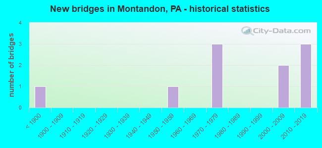
- New bridges - historical statistics
- 1Before 1900
- 11950-1959
- 31970-1979
- 22000-2009
- 32010-2019


- Bridge Condition - Deck
- 75.0%Very good
- 12.5%Good
- 12.5%Satisfactory

- Bridge Condition - Superstructure
- 62.5%Very good
- 37.5%Satisfactory

- Bridge Condition - Substructure
- 25.0%Very good
- 62.5%Good
- 12.5%Satisfactory

- Bridge Condition - Channel
- 16.7%Very good
- 16.7%Good
- 16.7%Satisfactory
- 50.0%Fair
Find on map >> Show street view
Structure Number: 28974, Location: 5.0 MI E OF MONTANDON (Lat: 40.974358, Lng: -76.803919), Route carried "on" structure: State highway 45, Year Built: 1952, Status: Open, Structure Length: 7.16m (23.49ft), Average Daily Traffic: 3,867 (year 2022), Truck Traffic: 7%, Average Future Daily Traffic: 5,587 (year 2032), Design Load: HL 93, Features Intersected: CHILLISQUAQUE CREEK
Minimum Vertical Clearance: 30+ m (98+ ft), Kilometerpoint: 6.235, Lanes on structure: 2, Base Highway Network: Yes, Owner: State Highway Agency, Approaching Roadway Width: 7.3m (24.0ft), Skew: 1 degrees, Material/Design: Steel continuous, Design/Construction: Stringer/Multi-beam, Number Of Spans In Main Unit: 3, Length of Maximum Span: 26.8m (87.9ft), Curb or Sidewalk Widths: Left: 0.2m (0.7ft), Right: 0.2m (0.7ft), Curb-To-Curb Width: 8.0m (26.2ft), Out-to-Out Width: 9.0m (29.5ft)
Condition: Deck: Very good, Superstructure: Satisfactory, Substructure: Good, Channel: Fair, Operating Rating: 48.0 metric tons, Method Used To Determine Operating Rating: Assigned ratings based on Load and Resistance Factor Design (LRFD) reported by rating factor (RF) using HL93 loadings, Inventory Rating: 36.9 metric tons, Method Used To Determine Inventory Rating: Assigned ratings based on Load and Resistance Factor Design (LRFD) reported by rating factor (RF) using HL93 loadings, Structural Evaluation: Equal to present minimum criteria, Deck Geometry: High priority of corrective action, Waterway Adequacy: Equal to present minimum criteria, Approach Roadway Alignment: Equal to present desirable criteria, Length Of Structure Improvement: 7.20m (23.62ft), Designated Inspection Frequency: Every 24 months, Underwater Inspection Frequency: Every 48 months, Inspection Date: November 2021, Underwater Inspection Date: July 2020, Bridge Improvement Cost: $32,000, Roadway Improvement Cost: $95,000, Total Project Cost: $434,000, Deck Structure Type: Concrete Cast-file-Place, Wearing Surface/Protective System: Wearing Surface: Bituminous, Membrane: Preformed Fabric
Find on map >> Show street view
Structure Number: 29055, Location: 0.5 MI E OF MONTANDON (Lat: 40.964747, Lng: -76.843922), Route carried "on" structure: State highway 147, Year Built: 1971, Status: Open, Structure Length: 5.36m (17.59ft), Average Daily Traffic: 6,251 (year 2020), Truck Traffic: 22%, Average Future Daily Traffic: 9,347 (year 2032), Design Load: HS 20, Features Intersected: OVER S.R. 45
Minimum Vertical Clearance: 30+ m (98+ ft), Kilometerpoint: 51.525, Lanes on structure: 2, Lanes under structure: 2, Base Highway Network: Yes, Owner: State Highway Agency, Approaching Roadway Width: 13.4m (44.0ft), Skew: 1 degrees, Material/Design: Prestressed concrete, Design/Construction: Stringer/Multi-beam, Number Of Spans In Main Unit: 3, Length of Maximum Span: 27.1m (88.9ft), Curb or Sidewalk Widths: Left: 0.2m (0.7ft), Right: 0.2m (0.7ft), Curb-To-Curb Width: 13.9m (45.6ft), Out-to-Out Width: 14.6m (47.9ft)
Condition: Deck: Good, Superstructure: Satisfactory, Substructure: Good, Operating Rating: 68.9 metric tons, Method Used To Determine Operating Rating: Load Factor (LF), Inventory Rating: 33.6 metric tons, Method Used To Determine Inventory Rating: Load Factor (LF), Structural Evaluation: Equal to present minimum criteria, Deck Geometry: Superior to present desirable criteria, Underclear: Superior to present desirable criteria, Approach Roadway Alignment: Equal to present desirable criteria, Length Of Structure Improvement: 5.20m (17.06ft), Designated Inspection Frequency: Every 24 months, Inspection Date: November 2021, Deck Structure Type: Concrete Cast-file-Place, Wearing Surface/Protective System: Wearing Surface: Latex Concrete, Deck Protection: Epoxy Coated Reinforcing
Find on map >> Show street view
Structure Number: 291, Location: 3.5 MI S OF MONTANDON (Lat: 40.940667, Lng: -76.854836), Route carried "on" structure: State highway 405, Year Built: 1974, Year Reconstructed: 2013, Status: Open, Structure Length: 4.75m (15.58ft), Average Daily Traffic: 3,484 (year 2020), Truck Traffic: 10%, Average Future Daily Traffic: 6,327 (year 2032), Design Load: HL 93, Features Intersected: CHILLISQUAQUE CREEK
Minimum Vertical Clearance: 30+ m (98+ ft), Kilometerpoint: 0.396, Lanes on structure: 2, Owner: State Highway Agency, Approaching Roadway Width: 13.4m (44.0ft), Material/Design: Prestressed concrete, Design/Construction: Box Beam or Girders - Single/Spread, Number Of Spans In Main Unit: 2, Length of Maximum Span: 23.5m (77.1ft), Curb or Sidewalk Widths: Left: 0.2m (0.7ft), Right: 0.2m (0.7ft), Curb-To-Curb Width: 14.6m (47.9ft), Out-to-Out Width: 15.9m (52.2ft)
Condition: Deck: Very good, Superstructure: Very good, Substructure: Good, Channel: Fair, Operating Rating: 52.2 metric tons, Method Used To Determine Operating Rating: Assigned ratings based on Load and Resistance Factor Design (LRFD) reported by rating factor (RF) using HL93 loadings, Inventory Rating: 39.9 metric tons, Method Used To Determine Inventory Rating: Assigned ratings based on Load and Resistance Factor Design (LRFD) reported by rating factor (RF) using HL93 loadings, Structural Evaluation: Better than present minimum criteria, Deck Geometry: Superior to present desirable criteria, Waterway Adequacy: Equal to present desirable criteria, Approach Roadway Alignment: Better than present minimum criteria, Length Of Structure Improvement: 4.80m (15.75ft), Designated Inspection Frequency: Every 48 months, Inspection Date: June 2019, Total Project Cost: $103,000, Deck Structure Type: Concrete Cast-file-Place, Wearing Surface/Protective System: Wearing Surface: Monolithic Concrete, Deck Protection: Epoxy Coated Reinforcing
Find on map >> Show street view
Structure Number: 29329, Location: T-573 (Snyder Road) (Lat: 40.960128, Lng: -76.815856), Route carried "on" structure: City street , Year Built: 1830, Year Reconstructed: 2013, Status: Posted for load, Structure Length: 3.35m (10.99ft), Average Daily Traffic: 100 (year 2019), Average Future Daily Traffic: 155 (year 2041), Design Load: HS 20, Features Intersected: CHILLISQUAQUE CREEK, Facility Carried by Structure: RISHEL COV. BRDG.
Minimum Vertical Clearance: 2.00m (6.56ft), Kilometerpoint: 0.000, Lanes on structure: 2, Owner: County Highway Agency, Approaching Roadway Width: 5.2m (17.1ft), Material/Design: Wood or Timber, Design/Construction: Truss - Thru, Number Of Spans In Main Unit: 1, Length of Maximum Span: 27.7m (90.9ft), Curb-To-Curb Width: 4.5m (14.8ft), Out-to-Out Width: 6.2m (20.3ft)
Condition: Deck: Satisfactory, Superstructure: Satisfactory, Substructure: Satisfactory, Channel: Fair, Operating Rating: 4.5 metric tons, Method Used To Determine Operating Rating: Allowable Stress (AS), Inventory Rating: 3.6 metric tons, Method Used To Determine Inventory Rating: Allowable Stress (AS), Structural Evaluation: High priority of corrective action, Deck Geometry: High priority of replacement, Waterway Adequacy: Better than present minimum criteria, Approach Roadway Alignment: Meets minimum limits, Bridge Posting: Required (Relationship of Operating Rating to Maximum Legal Load: > 39.9% below), Length Of Structure Improvement: 4.60m (15.09ft), Designated Inspection Frequency: Every 24 months, Other Special Inspection Frequency: Every 12 months, Inspection Date: Febuary 2021, Other Special Inspection Date: Febuary 2021, Bridge Improvement Cost: $1,000, Roadway Improvement Cost: $6,000, Total Project Cost: $9,000, Deck Structure Type: Wood or Timber, Wearing Surface/Protective System: Wearing Surface: Wood or Timber
Find on map >> Show street view
Structure Number: 42144, Location: 0.5 MI E OF MONTANDON (Lat: 40.964642, Lng: -76.843683), Route carried "on" structure: State highway 147, Year Built: 2003, Status: Open, Structure Length: 4.21m (13.81ft), Average Daily Traffic: 5,887 (year 2020), Truck Traffic: 21%, Average Future Daily Traffic: 9,193 (year 2032), Design Load: HL 93, Features Intersected: SR 45
Minimum Vertical Clearance: 30+ m (98+ ft), Kilometerpoint: 51.530, Lanes on structure: 2, Lanes under structure: 2, Base Highway Network: Yes, Owner: State Highway Agency, Approaching Roadway Width: 13.1m (43.0ft), Skew: 1 degrees, Material/Design: Prestressed concrete, Design/Construction: Stringer/Multi-beam, Number Of Spans In Main Unit: 1, Length of Maximum Span: 41.1m (134.8ft), Curb or Sidewalk Widths: Left: 0.2m (0.7ft), Right: 0.2m (0.7ft), Curb-To-Curb Width: 13.8m (45.3ft), Out-to-Out Width: 13.8m (45.3ft)
Condition: Deck: Very good, Superstructure: Very good, Substructure: Good, Inventory Rating: 43.5 metric tons, Method Used To Determine Inventory Rating: Load and Resistance Factor (LRFR), Structural Evaluation: Better than present minimum criteria, Deck Geometry: Superior to present desirable criteria, Underclear: Superior to present desirable criteria, Approach Roadway Alignment: Equal to present desirable criteria, Length Of Structure Improvement: 5.10m (16.73ft), Designated Inspection Frequency: Every 48 months, Inspection Date: November 2019, Deck Structure Type: Concrete Cast-file-Place, Wearing Surface/Protective System: Wearing Surface: Epoxy Overlay, Deck Protection: Epoxy Coated Reinforcing
Find on map >> Show street view
Structure Number: 48256, Location: 2 MI EAST OF MONTANDON (Lat: 40.974572, Lng: -76.800058), Route carried "on" structure: State highway , Year Built: 2013, Status: Open, Structure Length: 2.23m (7.32ft), Average Daily Traffic: 729 (year 2022), Truck Traffic: 8%, Average Future Daily Traffic: 207 (year 2038), Design Load: HL 93, Features Intersected: CHILLISQUAQUE CREEK, Facility Carried by Structure: SR 1025
Minimum Vertical Clearance: 30+ m (98+ ft), Kilometerpoint: 1.654, Lanes on structure: 2, Owner: State Highway Agency, Approaching Roadway Width: 7.3m (24.0ft), Material/Design: Prestressed concrete, Design/Construction: Box Beam or Girders - Single/Spread, Number Of Spans In Main Unit: 1, Length of Maximum Span: 21.6m (70.9ft), Curb or Sidewalk Widths: Left: 0.2m (0.7ft), Right: 0.2m (0.7ft), Curb-To-Curb Width: 7.5m (24.6ft), Out-to-Out Width: 8.5m (27.9ft)
Condition: Deck: Very good, Superstructure: Very good, Substructure: Very good, Channel: Satisfactory, Operating Rating: 69.3 metric tons, Method Used To Determine Operating Rating: Assigned ratings based on Load and Resistance Factor Design (LRFD) reported by rating factor (RF) using HL93 loadings, Inventory Rating: 38.9 metric tons, Method Used To Determine Inventory Rating: Assigned ratings based on Load and Resistance Factor Design (LRFD) reported by rating factor (RF) using HL93 loadings, Structural Evaluation: Equal to present desirable criteria, Deck Geometry: Meets minimum limits, Waterway Adequacy: Superior to present desirable criteria, Approach Roadway Alignment: Equal to present desirable criteria, Designated Inspection Frequency: Every 48 months, Inspection Date: November 2019, Deck Structure Type: Concrete Cast-file-Place, Wearing Surface/Protective System: Wearing Surface: Epoxy Overlay, Deck Protection: Epoxy Coated Reinforcing
Find on map >> Show street view
Structure Number: 48323, Location: 2 MI S OF MONTANDON (Lat: 40.941464, Lng: -76.856933), Route carried "on" structure: State highway 405, Year Built: 2013, Status: Open, Structure Length: 6.49m (21.29ft), Average Daily Traffic: 3,484 (year 2020), Truck Traffic: 10%, Average Future Daily Traffic: 6,534 (year 2037), Design Load: HL 93, Features Intersected: NSRR & TRIB CHILLISQ CRK
Minimum Vertical Clearance: 30+ m (98+ ft), Kilometerpoint: 0.756, Lanes on structure: 2, Owner: State Highway Agency, Approaching Roadway Width: 12.2m (40.0ft), Skew: 1 degrees, Material/Design: Steel continuous, Design/Construction: Stringer/Multi-beam, Number Of Spans In Main Unit: 2, Length of Maximum Span: 31.7m (104.0ft), Curb or Sidewalk Widths: Left: 0.2m (0.7ft), Right: 0.2m (0.7ft), Curb-To-Curb Width: 12.2m (40.0ft), Out-to-Out Width: 13.2m (43.3ft)
Condition: Deck: Very good, Superstructure: Very good, Substructure: Good, Channel: Very good, Operating Rating: 53.8 metric tons, Method Used To Determine Operating Rating: Assigned ratings based on Load and Resistance Factor Design (LRFD) reported by rating factor (RF) using HL93 loadings, Inventory Rating: 41.5 metric tons, Method Used To Determine Inventory Rating: Assigned ratings based on Load and Resistance Factor Design (LRFD) reported by rating factor (RF) using HL93 loadings, Structural Evaluation: Better than present minimum criteria, Deck Geometry: Equal to present minimum criteria, Underclear: High priority of corrective action, Waterway Adequacy: Superior to present desirable criteria, Approach Roadway Alignment: Better than present minimum criteria, Designated Inspection Frequency: Every 48 months, Inspection Date: November 2019, Deck Structure Type: Concrete Cast-file-Place, Wearing Surface/Protective System: Wearing Surface: Monolithic Concrete, Deck Protection: Epoxy Coated Reinforcing
Find on map >> Show street view
Structure Number: 54792, Location: VILLAGE OF CHILLISQUAQUE (Lat: 40.941833, Lng: -76.852056), Route carried "on" structure: State highway 147, Year Built: 2017, Status: Open, Structure Length: 10.12m (33.20ft), Average Daily Traffic: 7,261 (year 2022), Truck Traffic: 28%, Average Future Daily Traffic: 18,709 (year 2038), Design Load: HL 93, Features Intersected: OVER T-568&CHILLISQU. CR
Minimum Vertical Clearance: 30+ m (98+ ft), Kilometerpoint: 48.251, Lanes on structure: 2, Lanes under structure: 2, Base Highway Network: Yes, Owner: State Highway Agency, Approaching Roadway Width: 13.1m (43.0ft), Material/Design: Prestressed concrete continuous, Design/Construction: Stringer/Multi-beam, Number Of Spans In Main Unit: 3, Length of Maximum Span: 33.8m (110.9ft), Curb or Sidewalk Widths: Left: 0.2m (0.7ft), Right: 0.2m (0.7ft), Curb-To-Curb Width: 12.2m (40.0ft), Out-to-Out Width: 12.8m (42.0ft)
Condition: Deck: Very good, Superstructure: Very good, Substructure: Very good, Channel: Good, Operating Rating: 62.9 metric tons, Method Used To Determine Operating Rating: Assigned ratings based on Load and Resistance Factor Design (LRFD) reported by rating factor (RF) using HL93 loadings, Inventory Rating: 37.6 metric tons, Method Used To Determine Inventory Rating: Assigned ratings based on Load and Resistance Factor Design (LRFD) reported by rating factor (RF) using HL93 loadings, Structural Evaluation: Equal to present desirable criteria, Deck Geometry: Somewhat better than minimum adequacy, Underclear: Superior to present desirable criteria, Waterway Adequacy: Equal to present desirable criteria, Approach Roadway Alignment: Equal to present desirable criteria, Designated Inspection Frequency: Every 24 months, Inspection Date: November 2021, Deck Structure Type: Concrete Cast-file-Place, Wearing Surface/Protective System: Wearing Surface: Monolithic Concrete, Deck Protection: Epoxy Coated Reinforcing
Find on map >> Show street view
Structure Number: 29055, Location: 0.5 MI E OF MONTANDON (Lat: 40.964747, Lng: -76.843922), Route carried "under" structure: State highway 45, Year Built: 1971, Structure Length: 0. m, Average Daily Traffic: 3,867 (year 2022), Truck Traffic: 7%, Features Intersected: OVER S.R. 45, Facility Carried by Structure: SR 147
Minimum Vertical Clearance: 5.41m (17.75ft), Kilometerpoint: 2.565, Lanes on structure: 2, Lanes under structure: 2, Material/Design: Prestressed concrete, Design/Construction: Stringer/Multi-beam, Length of Maximum Span: 27.1m (88.9ft)
Find on map >> Show street view
Structure Number: 42144, Location: 0.5 MI E OF MONTANDON (Lat: 40.964642, Lng: -76.843683), Route carried "under" structure: State highway 45, Year Built: 2003, Structure Length: 0. m, Average Daily Traffic: 3,867 (year 2022), Truck Traffic: 7%, Features Intersected: SR 45, Facility Carried by Structure: SR 147
Minimum Vertical Clearance: 5.76m (18.90ft), Kilometerpoint: 2.565, Lanes on structure: 2, Lanes under structure: 2, Material/Design: Prestressed concrete, Design/Construction: Stringer/Multi-beam, Length of Maximum Span: 41.1m (134.8ft)