Bridge Statistics for Monroe, Pennsylvania (PA)
Condition, Traffic, Stress, Structural Evaluation, Project Costs
- National Bridge Inventory (NBI) Statistics
- 12Number of bridges
- 118ft / 36.4mTotal length
- $727,000Total costs
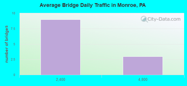
- 12,535Total average daily traffic
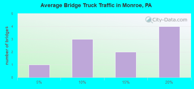
- 1,950Total average daily truck traffic
- 21,539Total future (year 2032) average daily traffic
- National Bridge Inventory (NBI) Registered Bridges for Monroe
- No street view available for this location
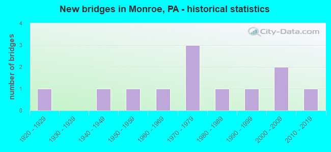
- New bridges - historical statistics
- 11920-1929
- 11940-1949
- 11950-1959
- 11960-1969
- 31970-1979
- 11980-1989
- 11990-1999
- 22000-2009
- 12010-2019
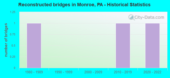
- Reconstructed bridges - Historical Statistics
- 11980-1989
- 01990-1999
- 02000-2009
- 12010-2019
- 12020-2022
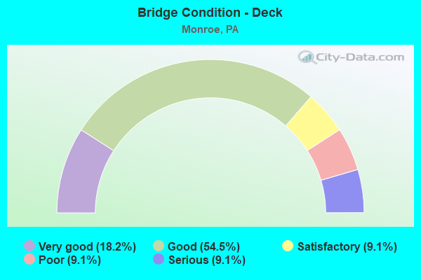
- Bridge Condition - Deck
- 18.2%Very good
- 54.5%Good
- 9.1%Satisfactory
- 9.1%Poor
- 9.1%Serious
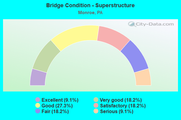
- Bridge Condition - Superstructure
- 9.1%Excellent
- 18.2%Very good
- 27.3%Good
- 18.2%Satisfactory
- 18.2%Fair
- 9.1%Serious
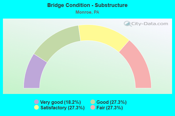
- Bridge Condition - Substructure
- 18.2%Very good
- 27.3%Good
- 27.3%Satisfactory
- 27.3%Fair
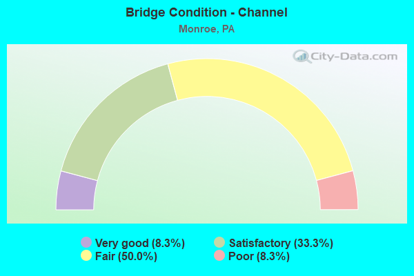
- Bridge Condition - Channel
- 8.3%Very good
- 33.3%Satisfactory
- 50.0%Fair
- 8.3%Poor
Find on map >> Show street view
Structure Number: 6138, Location: VILLAGE OF KELLOGG (Lat: 41.676775, Lng: -76.458378), Route carried "on" structure: US 220, Year Built: 1940, Status: Open, Structure Length: 0.64m (2.10ft), Average Daily Traffic: 3,634 (year 2022), Truck Traffic: 17%, Average Future Daily Traffic: 7,984 (year 2032), Features Intersected: KENT RUN CREEK
Minimum Vertical Clearance: 30+ m (98+ ft), Kilometerpoint: 15.524, Lanes on structure: 2, Base Highway Network: Yes, Owner: State Highway Agency, Approaching Roadway Width: 7.9m (25.9ft), Skew: 1 degrees, Material/Design: Concrete, Design/Construction: Culvert, Number Of Spans In Main Unit: 1, Length of Maximum Span: 6.4m (21.0ft)
Condition: Channel: Poor, Culverts: Fair, Operating Rating: 54.4 metric tons, Method Used To Determine Operating Rating: Field evaluation and documented engineering judgment, Inventory Rating: 32.7 metric tons, Method Used To Determine Inventory Rating: Field evaluation and documented engineering judgment, Structural Evaluation: Somewhat better than minimum adequacy, Waterway Adequacy: Superior to present desirable criteria, Approach Roadway Alignment: Equal to present desirable criteria, Length Of Structure Improvement: 0.60m (1.97ft), Designated Inspection Frequency: Every 24 months, Inspection Date: September 2021
Find on map >> Show street view
Structure Number: 6139, Location: 2 MI. S.OF MONROETON BORO (Lat: 41.698058, Lng: -76.463061), Route carried "on" structure: US 220, Year Built: 1928, Status: Open, Structure Length: 0.82m (2.69ft), Average Daily Traffic: 3,634 (year 2022), Truck Traffic: 17%, Average Future Daily Traffic: 5,628 (year 2032), Features Intersected: TRIB.TO S.BR.TOWANDA CR.
Minimum Vertical Clearance: 30+ m (98+ ft), Kilometerpoint: 17.531, Lanes on structure: 2, Base Highway Network: Yes, Owner: State Highway Agency, Approaching Roadway Width: 8.5m (27.9ft), Skew: 1 degrees, Material/Design: Concrete continuous, Design/Construction: Stringer/Multi-beam, Number Of Spans In Main Unit: 1, Length of Maximum Span: 7.6m (24.9ft), Curb-To-Curb Width: 7.0m (23.0ft), Out-to-Out Width: 7.8m (25.6ft)
Condition: Deck: Satisfactory, Superstructure: Satisfactory, Substructure: Satisfactory, Channel: Fair, Operating Rating: 54.4 metric tons, Method Used To Determine Operating Rating: Field evaluation and documented engineering judgment, Inventory Rating: 32.7 metric tons, Method Used To Determine Inventory Rating: Field evaluation and documented engineering judgment, Structural Evaluation: Equal to present minimum criteria, Deck Geometry: High priority of replacement, Waterway Adequacy: Superior to present desirable criteria, Approach Roadway Alignment: Equal to present desirable criteria, Length Of Structure Improvement: 0.80m (2.62ft), Designated Inspection Frequency: Every 24 months, Inspection Date: September 2021, Bridge Improvement Cost: $32,000, Roadway Improvement Cost: $148,000, Total Project Cost: $588,000, Deck Structure Type: Concrete Cast-file-Place, Wearing Surface/Protective System: Wearing Surface: Bituminous, Membrane: Preformed Fabric
Find on map >> Show street view
Structure Number: 614, Location: BORO OF MONROETON (Lat: 41.712342, Lng: -76.469903), Route carried "on" structure: US 220, Year Built: 1986, Status: Open, Structure Length: 11.73m (38.48ft), Average Daily Traffic: 3,634 (year 2022), Truck Traffic: 17%, Average Future Daily Traffic: 5,628 (year 2032), Design Load: HS 20+Mod, Features Intersected: TOWANDA CREEK
Minimum Vertical Clearance: 30+ m (98+ ft), Kilometerpoint: 18.899, Lanes on structure: 2, Base Highway Network: Yes, Owner: State Highway Agency, Approaching Roadway Width: 10.7m (35.1ft), Skew: 4 degrees, Material/Design: Steel continuous, Design/Construction: Stringer/Multi-beam, Number Of Spans In Main Unit: 3, Length of Maximum Span: 44.5m (146.0ft), Curb or Sidewalk Widths: Left: 0.2m (0.7ft), Right: 1.5m (4.9ft), Curb-To-Curb Width: 11.0m (36.1ft), Out-to-Out Width: 13.9m (45.6ft)
Condition: Deck: Good, Superstructure: Good, Substructure: Satisfactory, Channel: Satisfactory, Operating Rating: 65.3 metric tons, Method Used To Determine Operating Rating: Load Factor (LF), Inventory Rating: 39.0 metric tons, Method Used To Determine Inventory Rating: Load Factor (LF), Structural Evaluation: Equal to present minimum criteria, Deck Geometry: Somewhat better than minimum adequacy, Waterway Adequacy: Superior to present desirable criteria, Approach Roadway Alignment: Equal to present desirable criteria, Length Of Structure Improvement: 11.70m (38.39ft), Designated Inspection Frequency: Every 48 months, Inspection Date: July 2019, Deck Structure Type: Concrete Cast-file-Place, Wearing Surface/Protective System: Wearing Surface: Epoxy Overlay, Deck Protection: Epoxy Coated Reinforcing
Find on map >> Show street view
Structure Number: 6397, Location: 4 MILE SW 0F POWELL (Lat: 41.684764, Lng: -76.531050), Route carried "on" structure: State highway , Year Built: 1969, Status: Open, Structure Length: 4.72m (15.49ft), Average Daily Traffic: 72 (year 2019), Truck Traffic: 15%, Average Future Daily Traffic: 46 (year 2032), Design Load: HS 20, Features Intersected: SCHRADER BR TOWANDA CRK, Facility Carried by Structure: SR 3006
Minimum Vertical Clearance: 30+ m (98+ ft), Kilometerpoint: 0.000, Lanes on structure: 2, Owner: State Highway Agency, Approaching Roadway Width: 6.7m (22.0ft), Skew: 3 degrees, Material/Design: Prestressed concrete, Design/Construction: Stringer/Multi-beam, Number Of Spans In Main Unit: 2, Length of Maximum Span: 23.2m (76.1ft), Curb or Sidewalk Widths: Left: 0.2m (0.7ft), Right: 0.2m (0.7ft), Curb-To-Curb Width: 11.7m (38.4ft), Out-to-Out Width: 12.9m (42.3ft)
Condition: Deck: Good, Superstructure: Good, Substructure: Good, Channel: Satisfactory, Operating Rating: 70.8 metric tons, Method Used To Determine Operating Rating: Load Factor (LF), Inventory Rating: 24.5 metric tons, Method Used To Determine Inventory Rating: Load Factor (LF), Structural Evaluation: Equal to present minimum criteria, Deck Geometry: Superior to present desirable criteria, Waterway Adequacy: Better than present minimum criteria, Approach Roadway Alignment: Better than present minimum criteria, Length Of Structure Improvement: 5.60m (18.37ft), Designated Inspection Frequency: Every 24 months, Inspection Date: September 2021, Deck Structure Type: Concrete Cast-file-Place, Wearing Surface/Protective System: Wearing Surface: Monolithic Concrete
Find on map >> Show street view
Structure Number: 6605, Location: 2.7 MI. SOUTH OF POWELL (Lat: 41.666800, Lng: -76.516147), Route carried "on" structure: City street , Year Built: 1977, Year Reconstructed: 2020, Status: Open, Structure Length: 1.13m (3.71ft), Average Daily Traffic: 50 (year 2021), Average Future Daily Traffic: 77 (year 2043), Design Load: HS 20, Features Intersected: MILLSTONE CREEK, Facility Carried by Structure: T-348 (TWP. BR)
Minimum Vertical Clearance: 30+ m (98+ ft), Kilometerpoint: 0.000, Lanes on structure: 2, Owner: Town or Township Highway Agency, Approaching Roadway Width: 5.2m (17.1ft), Skew: 2 degrees, Material/Design: Prestressed concrete, Design/Construction: Box Beam or Girders - Multiple, Number Of Spans In Main Unit: 1, Length of Maximum Span: 11.0m (36.1ft), Curb-To-Curb Width: 5.9m (19.4ft), Out-to-Out Width: 6.5m (21.3ft)
Condition: Deck: Very good, Superstructure: Satisfactory, Substructure: Fair, Channel: Fair, Operating Rating: 47.2 metric tons, Method Used To Determine Operating Rating: Load Factor (LF), Inventory Rating: 28.1 metric tons, Method Used To Determine Inventory Rating: Load Factor (LF), Structural Evaluation: Somewhat better than minimum adequacy, Deck Geometry: Meets minimum limits, Waterway Adequacy: Equal to present minimum criteria, Approach Roadway Alignment: Equal to present desirable criteria, Length Of Structure Improvement: 1.10m (3.61ft), Designated Inspection Frequency: Every 24 months, Inspection Date: June 2021, Wearing Surface/Protective System: Wearing Surface: Monolithic Concrete, Deck Protection: Epoxy Coated Reinforcing
Find on map >> Show street view
Structure Number: 6608, Location: 1.5 Mile West of Monroe (Lat: 41.711700, Lng: -76.503158), Route carried "on" structure: City street , Year Built: 1950, Year Reconstructed: 1988, Status: Posted for load, Structure Length: 0.94m (3.08ft), Average Daily Traffic: 75 (year 2021), Average Future Daily Traffic: 116 (year 2043), Design Load: HS 20, Features Intersected: FRENCH RUN, Facility Carried by Structure: T410 (MONROE BR.2)
Minimum Vertical Clearance: 30+ m (98+ ft), Kilometerpoint: 0.000, Lanes on structure: 1, Owner: Town or Township Highway Agency, Approaching Roadway Width: 3.7m (12.1ft), Material/Design: Steel, Design/Construction: Stringer/Multi-beam, Number Of Spans In Main Unit: 1, Length of Maximum Span: 7.9m (25.9ft), Curb-To-Curb Width: 4.1m (13.5ft), Out-to-Out Width: 4.9m (16.1ft)
Condition: Deck: Poor, Superstructure: Fair, Substructure: Fair, Channel: Fair, Operating Rating: 36.3 metric tons, Method Used To Determine Operating Rating: Load Factor (LF), Inventory Rating: 21.8 metric tons, Method Used To Determine Inventory Rating: Load Factor (LF), Structural Evaluation: Somewhat better than minimum adequacy, Deck Geometry: Somewhat better than minimum adequacy, Waterway Adequacy: Better than present minimum criteria, Approach Roadway Alignment: Equal to present minimum criteria, Bridge Posting: Required (Relationship of Operating Rating to Maximum Legal Load: 20.0 - 29.9% below), Length Of Structure Improvement: 0.90m (2.95ft), Designated Inspection Frequency: Every 24 months, Other Special Inspection Frequency: Every 12 months, Inspection Date: November 2021, Other Special Inspection Date: June 2021, Bridge Improvement Cost: $5,000, Roadway Improvement Cost: $50,000, Total Project Cost: $69,000, Deck Structure Type: Open Grating
Find on map >> Show street view
Structure Number: 6609, Location: 1 M. W OF LIBERTY CORNERS (Lat: 41.700861, Lng: -76.451000), Route carried "on" structure: City street , Year Built: 1976, Status: Posted for load, Structure Length: 1.01m (3.31ft), Average Daily Traffic: 50 (year 2021), Truck Traffic: 10%, Average Future Daily Traffic: 77 (year 2043), Design Load: HS 20, Features Intersected: TRIB SO BR TOWANDA CREEK, Facility Carried by Structure: T-414 TWP .BR# 3
Minimum Vertical Clearance: 30+ m (98+ ft), Kilometerpoint: 0.000, Lanes on structure: 2, Owner: Town or Township Highway Agency, Approaching Roadway Width: 4.3m (14.1ft), Skew: 2 degrees, Material/Design: Prestressed concrete, Design/Construction: Box Beam or Girders - Multiple, Number Of Spans In Main Unit: 1, Length of Maximum Span: 9.1m (29.9ft), Curb or Sidewalk Widths: Left: 0.2m (0.7ft), Right: 0.2m (0.7ft), Curb-To-Curb Width: 5.5m (18.0ft), Out-to-Out Width: 6.6m (21.7ft)
Condition: Deck: Serious, Superstructure: Serious, Substructure: Fair, Channel: Fair, Operating Rating: 56.2 metric tons, Method Used To Determine Operating Rating: Load Factor (LF), Inventory Rating: 32.7 metric tons, Method Used To Determine Inventory Rating: Load Factor (LF), Structural Evaluation: High priority of corrective action, Deck Geometry: Meets minimum limits, Waterway Adequacy: Equal to present minimum criteria, Approach Roadway Alignment: Equal to present desirable criteria, Length Of Structure Improvement: 1.00m (3.28ft), Designated Inspection Frequency: Every 24 months, Other Special Inspection Frequency: Every 6 months, Inspection Date: June 2021, Other Special Inspection Date: December 2021, Bridge Improvement Cost: $5,000, Roadway Improvement Cost: $50,000, Total Project Cost: $70,000, Deck Structure Type: Other, Wearing Surface/Protective System: Wearing Surface: Bituminous
Find on map >> Show street view
Structure Number: 6611, Location: INT.L.R.08007 T416 POWELL (Lat: 41.705000, Lng: -76.505094), Route carried "on" structure: City street , Year Built: 1993, Status: Open, Structure Length: 4.05m (13.29ft), Average Daily Traffic: 650 (year 2021), Truck Traffic: 5%, Average Future Daily Traffic: 1,005 (year 2043), Design Load: HS 25 or greater, Features Intersected: SCHRADER CR., Facility Carried by Structure: T893(CO.BR.23)
Minimum Vertical Clearance: 30+ m (98+ ft), Kilometerpoint: 0.000, Lanes on structure: 2, Owner: County Highway Agency, Approaching Roadway Width: 8.5m (27.9ft), Material/Design: Prestressed concrete continuous, Design/Construction: Box Beam or Girders - Single/Spread, Number Of Spans In Main Unit: 2, Length of Maximum Span: 19.8m (65.0ft), Curb or Sidewalk Widths: Left: 1.5m (4.9ft), Right: 0.2m (0.7ft), Curb-To-Curb Width: 8.5m (27.9ft), Out-to-Out Width: 10.9m (35.8ft)
Condition: Deck: Good, Superstructure: Good, Substructure: Good, Channel: Fair, Operating Rating: 88.0 metric tons, Method Used To Determine Operating Rating: Load Factor (LF), Inventory Rating: 40.8 metric tons, Method Used To Determine Inventory Rating: Load Factor (LF), Structural Evaluation: Better than present minimum criteria, Deck Geometry: Somewhat better than minimum adequacy, Waterway Adequacy: Equal to present desirable criteria, Approach Roadway Alignment: Equal to present desirable criteria, Length Of Structure Improvement: 4.80m (15.75ft), Designated Inspection Frequency: Every 24 months, Inspection Date: June 2021, Deck Structure Type: Concrete Cast-file-Place, Wearing Surface/Protective System: Wearing Surface: Monolithic Concrete, Deck Protection: Epoxy Coated Reinforcing
Find on map >> Show street view
Structure Number: 6612, Location: INT T416 & T893 IN POWELL (Lat: 41.705031, Lng: -76.508592), Route carried "on" structure: City street , Year Built: 1974, Year Reconstructed: 2017, Status: Open, Structure Length: 3.35m (10.99ft), Average Daily Traffic: 200 (year 2021), Truck Traffic: 5%, Average Future Daily Traffic: 309 (year 2043), Design Load: HS 20, Features Intersected: TOWANDA CREEK, Facility Carried by Structure: T-893 (CO.BR.#24)
Minimum Vertical Clearance: 30+ m (98+ ft), Kilometerpoint: 0.000, Lanes on structure: 2, Owner: County Highway Agency, Approaching Roadway Width: 5.5m (18.0ft), Skew: 1 degrees, Material/Design: Prestressed concrete, Design/Construction: Box Beam or Girders - Multiple, Number Of Spans In Main Unit: 2, Length of Maximum Span: 16.2m (53.1ft), Curb or Sidewalk Widths: Left: 1.5m (4.9ft), Right: 0.0m, Curb-To-Curb Width: 7.2m (23.6ft), Out-to-Out Width: 9.4m (30.8ft)
Condition: Deck: Very good, Superstructure: Fair, Substructure: Satisfactory, Channel: Fair, Operating Rating: 43.5 metric tons, Method Used To Determine Operating Rating: Load Factor (LF), Inventory Rating: 8.2 metric tons, Method Used To Determine Inventory Rating: Load Factor (LF), Structural Evaluation: High priority of corrective action, Deck Geometry: Meets minimum limits, Waterway Adequacy: Better than present minimum criteria, Approach Roadway Alignment: Equal to present desirable criteria, Length Of Structure Improvement: 3.40m (11.15ft), Designated Inspection Frequency: Every 24 months, Inspection Date: June 2021, Deck Structure Type: Concrete Cast-file-Place, Wearing Surface/Protective System: Wearing Surface: Monolithic Concrete, Deck Protection: Epoxy Coated Reinforcing
Find on map >> Show street view
Structure Number: 41842, Location: 1 MI. S. OF MONROETON (Lat: 41.700439, Lng: -76.463958), Route carried "on" structure: City street , Year Built: 2002, Status: Open, Structure Length: 2.99m (9.81ft), Average Daily Traffic: 250 (year 2021), Truck Traffic: 5%, Average Future Daily Traffic: 387 (year 2043), Design Load: HL 93, Features Intersected: SOUTH BR.TOWANDA CREEK, Facility Carried by Structure: T-893
Minimum Vertical Clearance: 30+ m (98+ ft), Kilometerpoint: 0.000, Lanes on structure: 2, Owner: County Highway Agency, Approaching Roadway Width: 6.1m (20.0ft), Material/Design: Prestressed concrete, Design/Construction: Box Beam or Girders - Multiple, Number Of Spans In Main Unit: 1, Length of Maximum Span: 29.6m (97.1ft), Curb or Sidewalk Widths: Left: 0.2m (0.7ft), Right: 0.2m (0.7ft), Curb-To-Curb Width: 9.3m (30.5ft), Out-to-Out Width: 10.1m (33.1ft)
Condition: Deck: Good, Superstructure: Very good, Substructure: Very good, Channel: Very good, Operating Rating: 91.6 metric tons, Method Used To Determine Operating Rating: Load and Resistance Factor (LRFR), Inventory Rating: 59.0 metric tons, Method Used To Determine Inventory Rating: Load and Resistance Factor (LRFR), Structural Evaluation: Equal to present desirable criteria, Deck Geometry: Equal to present minimum criteria, Waterway Adequacy: Superior to present desirable criteria, Approach Roadway Alignment: Equal to present desirable criteria, Length Of Structure Improvement: 3.70m (12.14ft), Designated Inspection Frequency: Every 24 months, Inspection Date: June 2021, Deck Structure Type: Concrete Cast-file-Place, Wearing Surface/Protective System: Wearing Surface: Monolithic Concrete, Deck Protection: Epoxy Coated Reinforcing
Find on map >> Show street view
Structure Number: 45541, Location: 2 MILE SOUTH OF POWELL (Lat: 41.683583, Lng: -76.531806), Route carried "on" structure: State highway , Year Built: 2009, Status: Open, Structure Length: 2.68m (8.79ft), Average Daily Traffic: 235 (year 2022), Truck Traffic: 13%, Average Future Daily Traffic: 225 (year 2032), Design Load: HL 93, Features Intersected: MILLSTONE CREEK, Facility Carried by Structure: SR 3006
Minimum Vertical Clearance: 30+ m (98+ ft), Kilometerpoint: 0.047, Lanes on structure: 2, Owner: State Highway Agency, Approaching Roadway Width: 7.3m (24.0ft), Skew: 1 degrees, Material/Design: Prestressed concrete, Design/Construction: Box Beam or Girders - Multiple, Number Of Spans In Main Unit: 1, Length of Maximum Span: 26.2m (86.0ft), Curb or Sidewalk Widths: Left: 0.2m (0.7ft), Right: 0.2m (0.7ft), Curb-To-Curb Width: 7.8m (25.6ft), Out-to-Out Width: 8.8m (28.9ft)
Condition: Deck: Good, Superstructure: Very good, Substructure: Very good, Channel: Satisfactory, Operating Rating: 68.0 metric tons, Method Used To Determine Operating Rating: Load and Resistance Factor (LRFR), Inventory Rating: 38.1 metric tons, Method Used To Determine Inventory Rating: Load and Resistance Factor (LRFR), Structural Evaluation: Equal to present desirable criteria, Deck Geometry: Somewhat better than minimum adequacy, Waterway Adequacy: Better than present minimum criteria, Approach Roadway Alignment: Somewhat better than minimum adequacy, Designated Inspection Frequency: Every 24 months, Inspection Date: September 2021, Deck Structure Type: Concrete Cast-file-Place, Wearing Surface/Protective System: Wearing Surface: Epoxy Overlay, Deck Protection: Epoxy Coated Reinforcing
Find on map >> Show street view
Structure Number: 4895, Location: 0.5 MI NW OF SOUTH BRANCH (Lat: 41.663450, Lng: -76.454253), Route carried "on" structure: City street , Year Built: 2014, Status: Open, Structure Length: 2.29m (7.51ft), Average Daily Traffic: 51 (year 2021), Truck Traffic: 1%, Average Future Daily Traffic: 57 (year 2043), Design Load: HL 93, Features Intersected: SOUTH BRANCH TOWANDA CRK, Facility Carried by Structure: T-402 KELLOG ROAD
Minimum Vertical Clearance: 30+ m (98+ ft), Kilometerpoint: 0.000, Lanes on structure: 2, Owner: County Highway Agency, Approaching Roadway Width: 7.3m (24.0ft), Skew: 2 degrees, Material/Design: Prestressed concrete, Design/Construction: Box Beam or Girders - Single/Spread, Number Of Spans In Main Unit: 1, Length of Maximum Span: 22.6m (74.1ft), Curb-To-Curb Width: 7.5m (24.6ft), Out-to-Out Width: 8.4m (27.6ft)
Condition: Deck: Good, Superstructure: Excellent, Substructure: Good, Channel: Satisfactory, Operating Rating: 51.2 metric tons, Method Used To Determine Operating Rating: Assigned ratings based on Load and Resistance Factor Design (LRFD) reported by rating factor (RF) using HL93 loadings, Inventory Rating: 38.9 metric tons, Method Used To Determine Inventory Rating: Assigned ratings based on Load and Resistance Factor Design (LRFD) reported by rating factor (RF) using HL93 loadings, Structural Evaluation: Better than present minimum criteria, Deck Geometry: Equal to present minimum criteria, Waterway Adequacy: Equal to present desirable criteria, Approach Roadway Alignment: Meets minimum limits, Designated Inspection Frequency: Every 24 months, Inspection Date: June 2021, Deck Structure Type: Concrete Cast-file-Place, Wearing Surface/Protective System: Wearing Surface: Monolithic Concrete, Deck Protection: Epoxy Coated Reinforcing