Bridge Statistics for Moapa Town, Nevada (NV)
Condition, Traffic, Stress, Structural Evaluation, Project Costs
- National Bridge Inventory (NBI) Statistics
- 18Number of bridges
- 233ft / 70.8mTotal length
- $1,024,000Total costs
- 115,598Total average daily traffic
- 26,268Total average daily truck traffic
- National Bridge Inventory (NBI) Registered Bridges for Moapa Town
- No street view available for this location
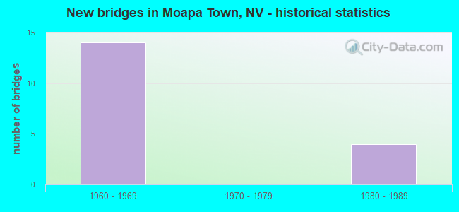
- New bridges - historical statistics
- 141960-1969
- 41980-1989


- Bridge Condition - Deck
- 78.6%Good
- 21.4%Satisfactory

- Bridge Condition - Superstructure
- 7.1%Very good
- 71.4%Good
- 21.4%Satisfactory

- Bridge Condition - Substructure
- 71.4%Good
- 28.6%Satisfactory

- Bridge Condition - Channel
- 20.0%Very good
- 80.0%Satisfactory
Find on map >> Show street view
Structure Number: B 81, Location: GLENDALE (Lat: 36.663386, Lng: -114.571433), Route carried "on" structure: ServiceOther road CL19, Year Built: 1988, Status: Open, Structure Length: 5.61m (18.41ft), Average Daily Traffic: 2,200 (year 2017), Truck Traffic: 8%, Average Future Daily Traffic: 4,550 (year 2040), Design Load: HS 20+Mod, Features Intersected: MUDDY RVR
Minimum Vertical Clearance: 30+ m (98+ ft), Kilometerpoint: 1.146, Lanes on structure: 2, Owner: State Highway Agency, Approaching Roadway Width: 11.6m (38.1ft), Material/Design: Steel continuous, Design/Construction: Stringer/Multi-beam, Number Of Spans In Main Unit: 3, Length of Maximum Span: 25.0m (82.0ft), Curb-To-Curb Width: 11.6m (38.1ft), Out-to-Out Width: 12.5m (41.0ft)
Condition: Deck: Satisfactory, Superstructure: Good, Substructure: Good, Channel: Satisfactory, Operating Rating: 69.8 metric tons, Method Used To Determine Operating Rating: Load Factor (LF), Inventory Rating: 41.7 metric tons, Method Used To Determine Inventory Rating: Load Factor (LF), Structural Evaluation: Better than present minimum criteria, Deck Geometry: Somewhat better than minimum adequacy, Waterway Adequacy: Superior to present desirable criteria, Approach Roadway Alignment: Equal to present desirable criteria, Designated Inspection Frequency: Every 24 months, Inspection Date: November 2020, Deck Structure Type: Concrete Cast-file-Place, Wearing Surface/Protective System: Wearing Surface: Monolithic Concrete
Find on map >> Show street view
Structure Number: B 281, Location: GLENDALE (Lat: 36.661889, Lng: -114.576111), Route carried "on" structure: State highway 168, Year Built: 1988, Status: Open, Structure Length: 4.08m (13.39ft), Average Daily Traffic: 2,200 (year 2017), Truck Traffic: 20%, Average Future Daily Traffic: 4,550 (year 2040), Design Load: HS 20+Mod, Features Intersected: MUDDY RVR
Minimum Vertical Clearance: 30+ m (98+ ft), Kilometerpoint: 1.801, Lanes on structure: 2, Owner: State Highway Agency, Approaching Roadway Width: 12.2m (40.0ft), Material/Design: Steel continuous, Design/Construction: Stringer/Multi-beam, Number Of Spans In Main Unit: 3, Length of Maximum Span: 18.3m (60.0ft), Curb-To-Curb Width: 12.2m (40.0ft), Out-to-Out Width: 13.1m (43.0ft)
Condition: Deck: Satisfactory, Superstructure: Good, Substructure: Good, Channel: Satisfactory, Operating Rating: 73.5 metric tons, Method Used To Determine Operating Rating: Load Factor (LF), Inventory Rating: 44.1 metric tons, Method Used To Determine Inventory Rating: Load Factor (LF), Structural Evaluation: Better than present minimum criteria, Deck Geometry: Equal to present minimum criteria, Waterway Adequacy: Equal to present desirable criteria, Approach Roadway Alignment: Equal to present desirable criteria, Designated Inspection Frequency: Every 24 months, Inspection Date: November 2020, Deck Structure Type: Concrete Cast-file-Place, Wearing Surface/Protective System: Wearing Surface: Monolithic Concrete
Find on map >> Show street view
Structure Number: B 781N, Location: GLENDALE (Lat: 36.663028, Lng: -114.570450), Route carried "on" structure: Interstate 15, Year Built: 1962, Status: Open, Structure Length: 8.27m (27.13ft), Average Daily Traffic: 10,000 (year 2017), Truck Traffic: 27%, Average Future Daily Traffic: 20,681 (year 2040), Design Load: HS 20+Mod, Features Intersected: MUDDY RIVER
Minimum Vertical Clearance: 30+ m (98+ ft), Kilometerpoint: 146.709, Lanes on structure: 2, Base Highway Network: Yes, Owner: State Highway Agency, Approaching Roadway Width: 11.6m (38.1ft), Skew: 3 degrees, Material/Design: Prestressed concrete, Design/Construction: Stringer/Multi-beam, Number Of Spans In Main Unit: 3, Length of Maximum Span: 27.7m (90.9ft), Curb-To-Curb Width: 11.6m (38.1ft), Out-to-Out Width: 13.1m (43.0ft)
Condition: Deck: Good, Superstructure: Very good, Substructure: Good, Channel: Satisfactory, Operating Rating: 59.4 metric tons, Method Used To Determine Operating Rating: Load Factor (LF), Inventory Rating: 35.2 metric tons, Method Used To Determine Inventory Rating: Load Factor (LF), Structural Evaluation: Better than present minimum criteria, Deck Geometry: Equal to present minimum criteria, Waterway Adequacy: Equal to present desirable criteria, Approach Roadway Alignment: Equal to present desirable criteria, Designated Inspection Frequency: Every 24 months, Underwater Inspection Frequency: Every 48 months, Inspection Date: September 2021, Underwater Inspection Date: August 2019, Deck Structure Type: Concrete Cast-file-Place, Wearing Surface/Protective System: Wearing Surface: Bituminous
Find on map >> Show street view
Structure Number: B 781S, Location: GLENDALE (Lat: 36.663167, Lng: -114.570794), Route carried "on" structure: Interstate 15, Year Built: 1962, Status: Open, Structure Length: 8.25m (27.07ft), Average Daily Traffic: 10,000 (year 2017), Truck Traffic: 27%, Average Future Daily Traffic: 20,681 (year 2040), Design Load: HS 20+Mod, Features Intersected: MUDDY RIVER
Minimum Vertical Clearance: 30+ m (98+ ft), Kilometerpoint: 146.709, Lanes on structure: 2, Base Highway Network: Yes, Owner: State Highway Agency, Approaching Roadway Width: 11.6m (38.1ft), Skew: 3 degrees, Material/Design: Prestressed concrete, Design/Construction: Stringer/Multi-beam, Number Of Spans In Main Unit: 3, Length of Maximum Span: 27.7m (90.9ft), Curb-To-Curb Width: 11.6m (38.1ft), Out-to-Out Width: 13.1m (43.0ft)
Condition: Deck: Good, Superstructure: Good, Substructure: Good, Channel: Satisfactory, Operating Rating: 59.4 metric tons, Method Used To Determine Operating Rating: Load Factor (LF), Inventory Rating: 35.2 metric tons, Method Used To Determine Inventory Rating: Load Factor (LF), Structural Evaluation: Better than present minimum criteria, Deck Geometry: Equal to present minimum criteria, Waterway Adequacy: Equal to present desirable criteria, Approach Roadway Alignment: Equal to present desirable criteria, Designated Inspection Frequency: Every 24 months, Underwater Inspection Frequency: Every 48 months, Inspection Date: September 2021, Underwater Inspection Date: August 2019, Deck Structure Type: Concrete Cast-file-Place, Wearing Surface/Protective System: Wearing Surface: Bituminous
Find on map >> Show street view
Structure Number: G 208, Location: MOAPA (Lat: 36.675781, Lng: -114.621456), Route carried "on" structure: State highway 168, Year Built: 1988, Status: Open, Structure Length: 5.94m (19.49ft), Average Daily Traffic: 1,100 (year 2017), Truck Traffic: 8%, Average Future Daily Traffic: 2,275 (year 2040), Design Load: HS 20+Mod, Features Intersected: UPRR
Minimum Vertical Clearance: 30+ m (98+ ft), Kilometerpoint: 6.307, Lanes on structure: 2, Owner: State Highway Agency, Approaching Roadway Width: 12.5m (41.0ft), Skew: 2 degrees, Material/Design: Steel continuous, Design/Construction: Stringer/Multi-beam, Number Of Spans In Main Unit: 3, Length of Maximum Span: 29.3m (96.1ft), Curb-To-Curb Width: 12.2m (40.0ft), Out-to-Out Width: 13.1m (43.0ft)
Condition: Deck: Satisfactory, Superstructure: Good, Substructure: Good, Operating Rating: 65.3 metric tons, Method Used To Determine Operating Rating: Load Factor (LF), Inventory Rating: 39.2 metric tons, Method Used To Determine Inventory Rating: Load Factor (LF), Structural Evaluation: Better than present minimum criteria, Deck Geometry: Better than present minimum criteria, Underclear: Superior to present desirable criteria, Approach Roadway Alignment: Equal to present desirable criteria, Designated Inspection Frequency: Every 24 months, Inspection Date: December 2020, Deck Structure Type: Concrete Cast-file-Place, Wearing Surface/Protective System: Wearing Surface: Monolithic Concrete
Find on map >> Show street view
Structure Number: G 779N, Location: GLENDALE (Lat: 36.658825, Lng: -114.575942), Route carried "on" structure: Interstate 15, Year Built: 1962, Status: Open, Structure Length: 4.75m (15.58ft), Average Daily Traffic: 8,500 (year 2017), Truck Traffic: 24%, Average Future Daily Traffic: 12,655 (year 2040), Design Load: HS 20+Mod, Features Intersected: UPRR
Minimum Vertical Clearance: 30+ m (98+ ft), Kilometerpoint: 146.001, Lanes on structure: 2, Lanes under structure: 2, Base Highway Network: Yes, Owner: State Highway Agency, Approaching Roadway Width: 11.6m (38.1ft), Skew: 1 degrees, Material/Design: Prestressed concrete, Design/Construction: Box Beam or Girders - Multiple, Number Of Spans In Main Unit: 3, Length of Maximum Span: 15.8m (51.8ft), Curb-To-Curb Width: 11.6m (38.1ft), Out-to-Out Width: 13.1m (43.0ft)
Condition: Deck: Good, Superstructure: Satisfactory, Substructure: Good, Operating Rating: 80.9 metric tons, Method Used To Determine Operating Rating: Load Factor (LF), Inventory Rating: 48.3 metric tons, Method Used To Determine Inventory Rating: Load Factor (LF), Structural Evaluation: Equal to present minimum criteria, Deck Geometry: Equal to present minimum criteria, Underclear: Somewhat better than minimum adequacy, Approach Roadway Alignment: Equal to present desirable criteria, Designated Inspection Frequency: Every 48 months, Inspection Date: November 2020, Deck Structure Type: Concrete Cast-file-Place, Wearing Surface/Protective System: Wearing Surface: Bituminous
Find on map >> Show street view
Structure Number: G 779S, Location: GLENDALE (Lat: 36.658897, Lng: -114.576272), Route carried "on" structure: Interstate 15, Year Built: 1962, Status: Open, Structure Length: 4.75m (15.58ft), Average Daily Traffic: 8,500 (year 2017), Truck Traffic: 24%, Average Future Daily Traffic: 12,655 (year 2040), Design Load: HS 20+Mod, Features Intersected: UPRR
Minimum Vertical Clearance: 30+ m (98+ ft), Kilometerpoint: 146.001, Lanes on structure: 3, Lanes under structure: 2, Base Highway Network: Yes, Owner: State Highway Agency, Approaching Roadway Width: 17.2m (56.4ft), Skew: 1 degrees, Material/Design: Prestressed concrete, Design/Construction: Box Beam or Girders - Multiple, Number Of Spans In Main Unit: 3, Length of Maximum Span: 15.8m (51.8ft), Curb-To-Curb Width: 17.2m (56.4ft), Out-to-Out Width: 18.8m (61.7ft)
Condition: Deck: Good, Superstructure: Satisfactory, Substructure: Good, Operating Rating: 80.9 metric tons, Method Used To Determine Operating Rating: Load Factor (LF), Inventory Rating: 48.3 metric tons, Method Used To Determine Inventory Rating: Load Factor (LF), Structural Evaluation: Equal to present minimum criteria, Deck Geometry: Better than present minimum criteria, Underclear: Somewhat better than minimum adequacy, Approach Roadway Alignment: Equal to present desirable criteria, Designated Inspection Frequency: Every 48 months, Inspection Date: November 2020, Deck Structure Type: Concrete Cast-file-Place, Wearing Surface/Protective System: Wearing Surface: Bituminous
Find on map >> Show street view
Structure Number: I 780N, Location: GLENDALE (Lat: 36.660581, Lng: -114.574058), Route carried "on" structure: Interstate 15, Year Built: 1962, Status: Open, Structure Length: 3.75m (12.30ft), Average Daily Traffic: 8,500 (year 2017), Truck Traffic: 27%, Average Future Daily Traffic: 17,579 (year 2040), Design Load: HS 20+Mod, Features Intersected: SR168 GLENDALE/MOAPA
Minimum Vertical Clearance: 30+ m (98+ ft), Kilometerpoint: 146.257, Lanes on structure: 3, Lanes under structure: 1, Base Highway Network: Yes, Owner: State Highway Agency, Approaching Roadway Width: 11.6m (38.1ft), Material/Design: Concrete continuous, Design/Construction: Slab, Number Of Spans In Main Unit: 3, Length of Maximum Span: 14.3m (46.9ft), Curb-To-Curb Width: 15.8m (51.8ft), Out-to-Out Width: 17.4m (57.1ft)
Condition: Deck: Good, Superstructure: Good, Substructure: Satisfactory, Operating Rating: 78.0 metric tons, Method Used To Determine Operating Rating: Load Factor (LF), Inventory Rating: 46.6 metric tons, Method Used To Determine Inventory Rating: Load Factor (LF), Structural Evaluation: Equal to present minimum criteria, Deck Geometry: Somewhat better than minimum adequacy, Underclear: Equal to present minimum criteria, Approach Roadway Alignment: Equal to present desirable criteria, Designated Inspection Frequency: Every 24 months, Inspection Date: January 2021, Deck Structure Type: Concrete Cast-file-Place, Wearing Surface/Protective System: Wearing Surface: Bituminous
Find on map >> Show street view
Structure Number: I 780S, Location: GLENDALE (Lat: 36.660739, Lng: -114.574317), Route carried "on" structure: Interstate 15, Year Built: 1962, Status: Open, Structure Length: 3.75m (12.30ft), Average Daily Traffic: 7,900 (year 2017), Truck Traffic: 27%, Average Future Daily Traffic: 16,338 (year 2040), Design Load: HS 20+Mod, Features Intersected: SR168 GLENDALE/MOAPA
Minimum Vertical Clearance: 30+ m (98+ ft), Kilometerpoint: 146.257, Lanes on structure: 2, Lanes under structure: 1, Base Highway Network: Yes, Owner: State Highway Agency, Approaching Roadway Width: 11.6m (38.1ft), Material/Design: Concrete continuous, Design/Construction: Slab, Number Of Spans In Main Unit: 3, Length of Maximum Span: 14.3m (46.9ft), Curb-To-Curb Width: 11.6m (38.1ft), Out-to-Out Width: 13.1m (43.0ft)
Condition: Deck: Good, Superstructure: Good, Substructure: Good, Operating Rating: 78.0 metric tons, Method Used To Determine Operating Rating: Load Factor (LF), Inventory Rating: 46.6 metric tons, Method Used To Determine Inventory Rating: Load Factor (LF), Structural Evaluation: Better than present minimum criteria, Deck Geometry: Equal to present minimum criteria, Underclear: Equal to present minimum criteria, Approach Roadway Alignment: Equal to present desirable criteria, Designated Inspection Frequency: Every 24 months, Inspection Date: January 2021, Deck Structure Type: Concrete Cast-file-Place, Wearing Surface/Protective System: Wearing Surface: Bituminous
Find on map >> Show street view
Structure Number: I 782N, Location: GLENDALE (Lat: 36.665236, Lng: -114.561897), Route carried "on" structure: Interstate 15, Year Built: 1962, Status: Open, Structure Length: 3.75m (12.30ft), Average Daily Traffic: 8,150 (year 2017), Truck Traffic: 27%, Average Future Daily Traffic: 13,225 (year 2040), Design Load: HS 20+Mod, Features Intersected: FR CL19
Minimum Vertical Clearance: 30+ m (98+ ft), Kilometerpoint: 147.496, Lanes on structure: 2, Lanes under structure: 2, Base Highway Network: Yes, Owner: State Highway Agency, Approaching Roadway Width: 11.6m (38.1ft), Material/Design: Concrete continuous, Design/Construction: Slab, Number Of Spans In Main Unit: 3, Length of Maximum Span: 14.3m (46.9ft), Curb-To-Curb Width: 11.6m (38.1ft), Out-to-Out Width: 13.1m (43.0ft)
Condition: Deck: Good, Superstructure: Good, Substructure: Good, Operating Rating: 78.6 metric tons, Method Used To Determine Operating Rating: Load Factor (LF), Inventory Rating: 47.0 metric tons, Method Used To Determine Inventory Rating: Load Factor (LF), Structural Evaluation: Better than present minimum criteria, Deck Geometry: Equal to present minimum criteria, Underclear: Somewhat better than minimum adequacy, Approach Roadway Alignment: Equal to present desirable criteria, Designated Inspection Frequency: Every 24 months, Inspection Date: January 2021, Deck Structure Type: Concrete Cast-file-Place, Wearing Surface/Protective System: Wearing Surface: Bituminous
Find on map >> Show street view
Structure Number: I 782S, Location: GLENDALE (Lat: 36.665550, Lng: -114.561897), Route carried "on" structure: Interstate 15, Year Built: 1962, Status: Open, Structure Length: 3.75m (12.30ft), Average Daily Traffic: 9,000 (year 2017), Truck Traffic: 27%, Average Future Daily Traffic: 13,225 (year 2040), Design Load: HS 20+Mod, Features Intersected: FR CL19
Minimum Vertical Clearance: 30+ m (98+ ft), Kilometerpoint: 147.496, Lanes on structure: 2, Lanes under structure: 2, Base Highway Network: Yes, Owner: State Highway Agency, Approaching Roadway Width: 11.6m (38.1ft), Material/Design: Concrete continuous, Design/Construction: Slab, Number Of Spans In Main Unit: 3, Length of Maximum Span: 14.3m (46.9ft), Curb-To-Curb Width: 11.6m (38.1ft), Out-to-Out Width: 13.1m (43.0ft)
Condition: Deck: Good, Superstructure: Good, Substructure: Good, Operating Rating: 78.6 metric tons, Method Used To Determine Operating Rating: Load Factor (LF), Inventory Rating: 47.0 metric tons, Method Used To Determine Inventory Rating: Load Factor (LF), Structural Evaluation: Better than present minimum criteria, Deck Geometry: Equal to present minimum criteria, Underclear: Equal to present minimum criteria, Approach Roadway Alignment: Equal to present desirable criteria, Designated Inspection Frequency: Every 24 months, Inspection Date: January 2021, Deck Structure Type: Concrete Cast-file-Place, Wearing Surface/Protective System: Wearing Surface: Bituminous
Find on map >> Show street view
Structure Number: I 783, Location: NORTH OF LOGANDALE (Lat: 36.670731, Lng: -114.521636), Route carried "on" structure: State highway 169, Year Built: 1962, Status: Open, Structure Length: 7.47m (24.51ft), Average Daily Traffic: 4,100 (year 2017), Truck Traffic: 20%, Average Future Daily Traffic: 8,479 (year 2040), Design Load: HS 20+Mod, Features Intersected: I 15
Minimum Vertical Clearance: 30+ m (98+ ft), Kilometerpoint: 151.146, Lanes on structure: 2, Lanes under structure: 5, Owner: State Highway Agency, Approaching Roadway Width: 7.9m (25.9ft), Material/Design: Concrete continuous, Design/Construction: Box Beam or Girders - Single/Spread, Number Of Spans In Main Unit: 4, Length of Maximum Span: 21.3m (69.9ft), Curb-To-Curb Width: 7.9m (25.9ft), Out-to-Out Width: 9.4m (30.8ft)
Condition: Deck: Good, Superstructure: Satisfactory, Substructure: Satisfactory, Operating Rating: 82.3 metric tons, Method Used To Determine Operating Rating: Load Factor (LF), Inventory Rating: 49.6 metric tons, Method Used To Determine Inventory Rating: Load Factor (LF), Structural Evaluation: Equal to present minimum criteria, Deck Geometry: High priority of corrective action, Underclear: Somewhat better than minimum adequacy, Approach Roadway Alignment: Equal to present desirable criteria, Length Of Structure Improvement: 8.49m (27.85ft), Designated Inspection Frequency: Every 48 months, Inspection Date: January 2021, Bridge Improvement Cost: $682,000, Roadway Improvement Cost: $68,000, Total Project Cost: $1,024,000, Deck Structure Type: Concrete Cast-file-Place, Wearing Surface/Protective System: Wearing Surface: Bituminous
Find on map >> Show street view
Structure Number: I 841N, Location: SOUTHWEST OF GLENDALE (Lat: 36.636711, Lng: -114.599122), Route carried "on" structure: Interstate 15, Year Built: 1961, Status: Open, Structure Length: 3.05m (10.01ft), Average Daily Traffic: 8,650 (year 2017), Truck Traffic: 24%, Average Future Daily Traffic: 34,500 (year 2040), Design Load: HS 20+Mod, Features Intersected: FR CL10 HIDDEN VLY
Minimum Vertical Clearance: 30+ m (98+ ft), Kilometerpoint: 142.784, Lanes on structure: 2, Lanes under structure: 2, Base Highway Network: Yes, Owner: State Highway Agency, Approaching Roadway Width: 11.6m (38.1ft), Material/Design: Concrete continuous, Design/Construction: Slab, Number Of Spans In Main Unit: 3, Length of Maximum Span: 11.6m (38.1ft), Curb-To-Curb Width: 11.6m (38.1ft), Out-to-Out Width: 13.1m (43.0ft)
Condition: Deck: Good, Superstructure: Good, Substructure: Satisfactory, Operating Rating: 67.8 metric tons, Method Used To Determine Operating Rating: Load Factor (LF), Inventory Rating: 40.5 metric tons, Method Used To Determine Inventory Rating: Load Factor (LF), Structural Evaluation: Equal to present minimum criteria, Deck Geometry: Equal to present minimum criteria, Underclear: Meets minimum limits, Approach Roadway Alignment: Equal to present desirable criteria, Designated Inspection Frequency: Every 48 months, Inspection Date: January 2021, Deck Structure Type: Concrete Cast-file-Place, Wearing Surface/Protective System: Wearing Surface: Bituminous
Find on map >> Show street view
Structure Number: I 841S, Location: SOUTHWEST OF GLENDALE (Lat: 36.637292, Lng: -114.599936), Route carried "on" structure: Interstate 15, Year Built: 1961, Status: Open, Structure Length: 3.05m (10.01ft), Average Daily Traffic: 8,650 (year 2017), Truck Traffic: 24%, Average Future Daily Traffic: 17,889 (year 2040), Design Load: HS 20+Mod, Features Intersected: FR CL10 HIDDEN VLY
Minimum Vertical Clearance: 30+ m (98+ ft), Kilometerpoint: 142.784, Lanes on structure: 2, Lanes under structure: 2, Base Highway Network: Yes, Owner: State Highway Agency, Approaching Roadway Width: 11.6m (38.1ft), Material/Design: Concrete continuous, Design/Construction: Slab, Number Of Spans In Main Unit: 3, Length of Maximum Span: 11.6m (38.1ft), Curb-To-Curb Width: 11.6m (38.1ft), Out-to-Out Width: 13.1m (43.0ft)
Condition: Deck: Good, Superstructure: Good, Substructure: Satisfactory, Operating Rating: 67.8 metric tons, Method Used To Determine Operating Rating: Load Factor (LF), Inventory Rating: 40.5 metric tons, Method Used To Determine Inventory Rating: Load Factor (LF), Structural Evaluation: Equal to present minimum criteria, Deck Geometry: Equal to present minimum criteria, Underclear: Meets minimum limits, Approach Roadway Alignment: Equal to present desirable criteria, Designated Inspection Frequency: Every 48 months, Inspection Date: January 2021, Deck Structure Type: Concrete Cast-file-Place, Wearing Surface/Protective System: Wearing Surface: Bituminous
Find on map >> Show street view
Structure Number: H69650B09, Location: N OF MOAPA POLICE STATION (Lat: 36.669250, Lng: -114.652250), Route carried "on" structure: Federal lands road 1, Year Built: 1980, Status: Open, Structure Length: 0.63m (2.07ft), Average Daily Traffic: 100 (year 2022), Truck Traffic: 2%, Average Future Daily Traffic: 120 (year 2039), Design Load: HS 20, Features Intersected: WASH
Minimum Vertical Clearance: 30+ m (98+ ft), Kilometerpoint: 0.100, Lanes on structure: 2, Owner: Bureau of Indian Affairs, Approaching Roadway Width: 7.9m (25.9ft), Material/Design: Concrete, Design/Construction: Culvert, Number Of Spans In Main Unit: 2, Length of Maximum Span: 3.1m (10.2ft), Curb-To-Curb Width: 7.9m (25.9ft), Out-to-Out Width: 13.3m (43.6ft)
Condition: Channel: Very good, Culverts: Good, Operating Rating: 44.2 metric tons, Method Used To Determine Operating Rating: Load Factor (LF), Inventory Rating: 32.4 metric tons, Method Used To Determine Inventory Rating: Load Factor (LF), Structural Evaluation: Better than present minimum criteria, Deck Geometry: Equal to present minimum criteria, Waterway Adequacy: Better than present minimum criteria, Approach Roadway Alignment: Equal to present desirable criteria, Designated Inspection Frequency: Every 24 months, Inspection Date: October 2021
Find on map >> Show street view
Structure Number: I 780N, Location: GLENDALE (Lat: 36.660581, Lng: -114.574058), Route carried "under" structure: State highway 168, Year Built: 1962, Structure Length: 0. m, Average Daily Traffic: 699 (year 2009), Truck Traffic: 4%, Features Intersected: SR168 GLENDALE/MOAPA, Facility Carried by Structure: I 15N
Minimum Vertical Clearance: 4.60m (15.09ft), Kilometerpoint: 146.257, Lanes on structure: 3, Lanes under structure: 1, Material/Design: Concrete continuous, Design/Construction: Slab, Length of Maximum Span: 14.3m (46.9ft)
Find on map >> Show street view
Structure Number: I 780S, Location: GLENDALE (Lat: 36.660739, Lng: -114.574317), Route carried "under" structure: State highway 168, Year Built: 1962, Structure Length: 0. m, Average Daily Traffic: 699 (year 2009), Truck Traffic: 4%, Features Intersected: SR168 GLENDALE/MOAPA, Facility Carried by Structure: I 15S
Minimum Vertical Clearance: 4.60m (15.09ft), Kilometerpoint: 146.257, Lanes on structure: 2, Lanes under structure: 1, Material/Design: Concrete continuous, Design/Construction: Slab, Length of Maximum Span: 14.3m (46.9ft)
Find on map >> Show street view
Structure Number: I 783, Location: NORTH OF LOGANDALE (Lat: 36.670731, Lng: -114.521636), Route carried "under" structure: Interstate 15, Year Built: 1962, Structure Length: 0. m, Average Daily Traffic: 16,650 (year 2009), Truck Traffic: 12%, Features Intersected: I 15, Facility Carried by Structure: SR169 LOGANDALE RD
Minimum Vertical Clearance: 5.49m (18.01ft), Kilometerpoint: 151.146, Lanes on structure: 2, Lanes under structure: 5, Material/Design: Concrete continuous, Design/Construction: Box Beam or Girders - Single/Spread, Length of Maximum Span: 21.3m (69.9ft)