Bridge Statistics for Mingus, Texas (TX)
Condition, Traffic, Stress, Structural Evaluation, Project Costs
- National Bridge Inventory (NBI) Statistics
- 20Number of bridges
- 200ft / 61.1mTotal length
- $11,000Total costs
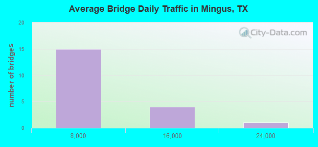
- 83,970Total average daily traffic
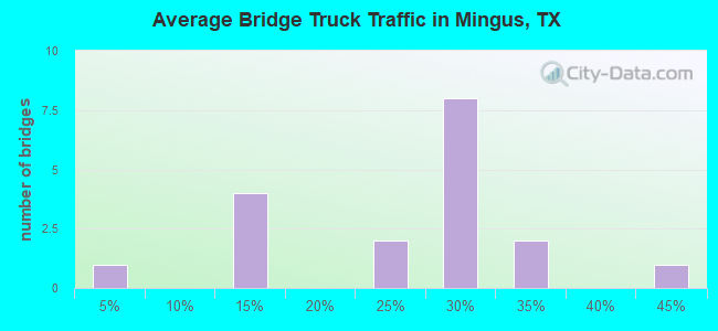
- 22,566Total average daily truck traffic
- National Bridge Inventory (NBI) Registered Bridges for Mingus
- No street view available for this location
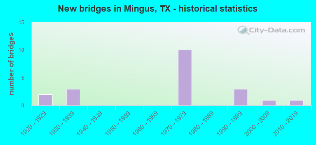
- New bridges - historical statistics
- 21920-1929
- 31930-1939
- 101970-1979
- 31990-1999
- 12000-2009
- 12010-2019
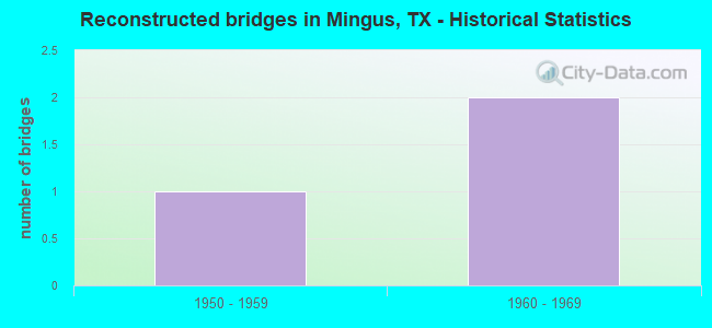
- Reconstructed bridges - Historical Statistics
- 11950-1959
- 21960-1969
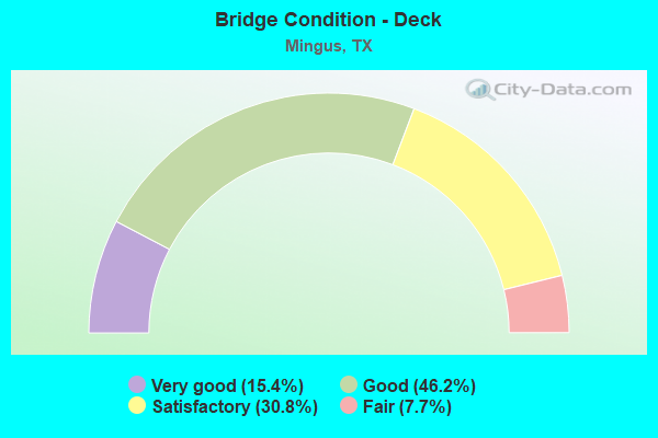
- Bridge Condition - Deck
- 15.4%Very good
- 46.2%Good
- 30.8%Satisfactory
- 7.7%Fair
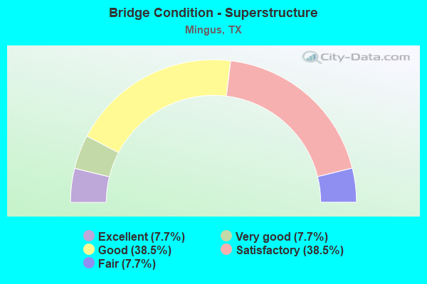
- Bridge Condition - Superstructure
- 7.7%Excellent
- 7.7%Very good
- 38.5%Good
- 38.5%Satisfactory
- 7.7%Fair
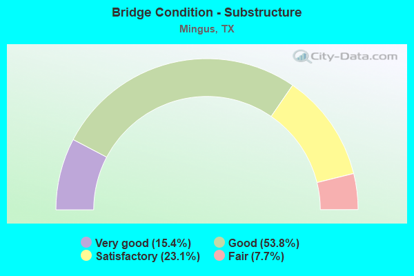
- Bridge Condition - Substructure
- 15.4%Very good
- 53.8%Good
- 23.1%Satisfactory
- 7.7%Fair

- Bridge Condition - Channel
- 62.5%Good
- 37.5%Satisfactory
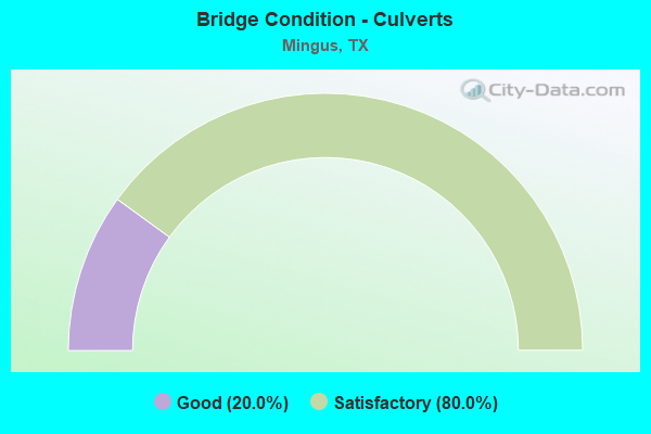
- Bridge Condition - Culverts
- 20.0%Good
- 80.0%Satisfactory
Find on map >> Show street view
Structure Number: 20730031404016, Location: 2.0 MI W OF SH 108 SOUTH (Lat: 32.507242, Lng: -98.405450), Route carried "on" structure: ServiceInterstate 20, Year Built: 1935, Year Reconstructed: 1960, Status: Open, Structure Length: 2.59m (8.50ft), Average Daily Traffic: 120 (year 2018), Truck Traffic: 28%, Average Future Daily Traffic: 170 (year 2038), Design Load: H 15, Features Intersected: GIBSON CREEK
Minimum Vertical Clearance: 30+ m (98+ ft), Kilometerpoint: 6.703, Lanes on structure: 2, Owner: State Highway Agency, Approaching Roadway Width: 12.2m (40.0ft), Material/Design: Concrete, Design/Construction: Tee Beam, Number Of Spans In Main Unit: 3, Length of Maximum Span: 8.5m (27.9ft), Curb-To-Curb Width: 13.4m (44.0ft), Out-to-Out Width: 14.0m (45.9ft)
Condition: Deck: Good, Superstructure: Good, Substructure: Good, Channel: Good, Operating Rating: 51.7 metric tons, Method Used To Determine Operating Rating: Load Factor (LF), Inventory Rating: 30.8 metric tons, Method Used To Determine Inventory Rating: Load Factor (LF), Structural Evaluation: Better than present minimum criteria, Deck Geometry: Superior to present desirable criteria, Waterway Adequacy: Equal to present minimum criteria, Approach Roadway Alignment: Equal to present desirable criteria, Designated Inspection Frequency: Every 24 months, Inspection Date: April 2021, Deck Structure Type: Concrete Cast-file-Place, Wearing Surface/Protective System: Wearing Surface: Bituminous
Find on map >> Show street view
Structure Number: 20730031404017, Location: 1.6 MI W OF SH 108 (Lat: 32.506378, Lng: -98.445153), Route carried "on" structure: ServiceInterstate 20, Year Built: 1934, Status: Open, Structure Length: 2.59m (8.50ft), Average Daily Traffic: 10 (year 2018), Truck Traffic: 31%, Average Future Daily Traffic: 10 (year 2038), Design Load: HS 20, Features Intersected: TURKEY CREEK
Minimum Vertical Clearance: 30+ m (98+ ft), Kilometerpoint: 2.927, Lanes on structure: 2, Owner: State Highway Agency, Approaching Roadway Width: 9.8m (32.2ft), Material/Design: Concrete, Design/Construction: Tee Beam, Number Of Spans In Main Unit: 3, Length of Maximum Span: 8.5m (27.9ft), Curb-To-Curb Width: 7.3m (24.0ft), Out-to-Out Width: 8.3m (27.2ft)
Condition: Deck: Good, Superstructure: Good, Substructure: Good, Channel: Good, Operating Rating: 67.1 metric tons, Method Used To Determine Operating Rating: Load Factor (LF), Inventory Rating: 39.9 metric tons, Method Used To Determine Inventory Rating: Load Factor (LF), Structural Evaluation: Better than present minimum criteria, Deck Geometry: Equal to present minimum criteria, Waterway Adequacy: Equal to present minimum criteria, Approach Roadway Alignment: Equal to present desirable criteria, Length Of Structure Improvement: 2.59m (8.50ft), Designated Inspection Frequency: Every 24 months, Inspection Date: April 2021, Bridge Improvement Cost: $4,000, Roadway Improvement Cost: $1,000, Total Project Cost: $5,000, Deck Structure Type: Concrete Cast-file-Place, Wearing Surface/Protective System: Wearing Surface: Bituminous
Find on map >> Show street view
Structure Number: 20730031404114, Location: 1.6 MI W OF SH 108 (Lat: 32.507358, Lng: -98.445064), Route carried "on" structure: ServiceInterstate 20, Year Built: 1970, Status: Open, Structure Length: 2.77m (9.09ft), Average Daily Traffic: 30 (year 2018), Truck Traffic: 30%, Average Future Daily Traffic: 40 (year 2038), Design Load: H 20, Features Intersected: TURKEY CREEK
Minimum Vertical Clearance: 30+ m (98+ ft), Kilometerpoint: 2.926, Lanes on structure: 2, Owner: State Highway Agency, Approaching Roadway Width: 12.2m (40.0ft), Material/Design: Concrete, Design/Construction: Stringer/Multi-beam, Number Of Spans In Main Unit: 3, Length of Maximum Span: 9.1m (29.9ft), Curb-To-Curb Width: 7.9m (25.9ft), Out-to-Out Width: 8.5m (27.9ft)
Condition: Deck: Good, Superstructure: Satisfactory, Substructure: Good, Channel: Satisfactory, Operating Rating: 58.0 metric tons, Method Used To Determine Operating Rating: Load Factor (LF), Inventory Rating: 34.5 metric tons, Method Used To Determine Inventory Rating: Load Factor (LF), Structural Evaluation: Equal to present minimum criteria, Deck Geometry: Equal to present minimum criteria, Waterway Adequacy: Equal to present minimum criteria, Approach Roadway Alignment: Equal to present desirable criteria, Length Of Structure Improvement: 2.77m (9.09ft), Designated Inspection Frequency: Every 24 months, Inspection Date: April 2021, Bridge Improvement Cost: $5,000, Roadway Improvement Cost: $1,000, Total Project Cost: $6,000, Deck Structure Type: Concrete Cast-file-Place, Wearing Surface/Protective System: Wearing Surface: Bituminous
Find on map >> Show street view
Structure Number: 20730031404115, Location: 1.6 MI W OF SH 108 (Lat: 32.506858, Lng: -98.445261), Route carried "on" structure: Interstate 20, Year Built: 1970, Status: Open, Structure Length: 2.77m (9.09ft), Average Daily Traffic: 12,840 (year 2019), Truck Traffic: 27%, Average Future Daily Traffic: 15,120 (year 2038), Design Load: HS 20, Features Intersected: TURKEY CREEK
Minimum Vertical Clearance: 30+ m (98+ ft), Kilometerpoint: 2.926, Lanes on structure: 2, Base Highway Network: Yes, Owner: State Highway Agency, Approaching Roadway Width: 11.6m (38.1ft), Material/Design: Concrete, Design/Construction: Stringer/Multi-beam, Number Of Spans In Main Unit: 3, Length of Maximum Span: 9.1m (29.9ft), Curb-To-Curb Width: 12.3m (40.4ft), Out-to-Out Width: 12.9m (42.3ft)
Condition: Deck: Satisfactory, Superstructure: Satisfactory, Substructure: Satisfactory, Channel: Good, Operating Rating: 68.0 metric tons, Method Used To Determine Operating Rating: Load Factor (LF), Inventory Rating: 40.8 metric tons, Method Used To Determine Inventory Rating: Load Factor (LF), Structural Evaluation: Equal to present minimum criteria, Deck Geometry: Better than present minimum criteria, Waterway Adequacy: Equal to present minimum criteria, Approach Roadway Alignment: Equal to present desirable criteria, Designated Inspection Frequency: Every 24 months, Inspection Date: April 2021, Deck Structure Type: Concrete Cast-file-Place, Wearing Surface/Protective System: Wearing Surface: Bituminous
Find on map >> Show street view
Structure Number: 20730031404116, Location: 1.6 MI W OF SH 108 (Lat: 32.506614, Lng: -98.445211), Route carried "on" structure: Interstate 20, Year Built: 1970, Status: Open, Structure Length: 2.77m (9.09ft), Average Daily Traffic: 13,589 (year 2019), Truck Traffic: 27%, Average Future Daily Traffic: 15,120 (year 2038), Design Load: HS 20, Features Intersected: TURKEY CREEK
Minimum Vertical Clearance: 30+ m (98+ ft), Kilometerpoint: 2.926, Lanes on structure: 2, Base Highway Network: Yes, Owner: State Highway Agency, Approaching Roadway Width: 11.6m (38.1ft), Material/Design: Concrete, Design/Construction: Stringer/Multi-beam, Number Of Spans In Main Unit: 3, Length of Maximum Span: 9.1m (29.9ft), Curb-To-Curb Width: 12.1m (39.7ft), Out-to-Out Width: 12.7m (41.7ft)
Condition: Deck: Satisfactory, Superstructure: Satisfactory, Substructure: Satisfactory, Channel: Good, Operating Rating: 68.0 metric tons, Method Used To Determine Operating Rating: Load Factor (LF), Inventory Rating: 40.8 metric tons, Method Used To Determine Inventory Rating: Load Factor (LF), Structural Evaluation: Equal to present minimum criteria, Deck Geometry: Equal to present minimum criteria, Waterway Adequacy: Equal to present minimum criteria, Approach Roadway Alignment: Equal to present desirable criteria, Designated Inspection Frequency: Every 24 months, Inspection Date: April 2021, Deck Structure Type: Concrete Cast-file-Place, Wearing Surface/Protective System: Wearing Surface: Bituminous
Find on map >> Show street view
Structure Number: 20730031404117, Location: 3.0 MI W OF FM 919 (Lat: 32.505953, Lng: -98.417722), Route carried "on" structure: Interstate 20, Year Built: 1970, Status: Open, Structure Length: 4.57m (14.99ft), Average Daily Traffic: 13,035 (year 2019), Truck Traffic: 27%, Average Future Daily Traffic: 15,120 (year 2038), Design Load: HS 20, Features Intersected: SH 108 NORTH
Minimum Vertical Clearance: 30+ m (98+ ft), Kilometerpoint: 5.528, Lanes on structure: 2, Lanes under structure: 2, Base Highway Network: Yes, Owner: State Highway Agency, Approaching Roadway Width: 11.6m (38.1ft), Material/Design: Prestressed concrete, Design/Construction: Stringer/Multi-beam, Number Of Spans In Main Unit: 1, Number Of Approach Spans: 2, Length of Maximum Span: 24.4m (80.1ft), Curb-To-Curb Width: 12.1m (39.7ft), Out-to-Out Width: 12.7m (41.7ft)
Condition: Deck: Fair, Superstructure: Satisfactory, Substructure: Satisfactory, Operating Rating: 68.0 metric tons, Method Used To Determine Operating Rating: Load Factor (LF), Inventory Rating: 32.7 metric tons, Method Used To Determine Inventory Rating: Load Factor (LF), Structural Evaluation: Equal to present minimum criteria, Deck Geometry: Equal to present minimum criteria, Underclear: Superior to present desirable criteria, Approach Roadway Alignment: Equal to present desirable criteria, Designated Inspection Frequency: Every 24 months, Inspection Date: April 2021, Deck Structure Type: Concrete Cast-file-Place, Wearing Surface/Protective System: Wearing Surface: Bituminous
Find on map >> Show street view
Structure Number: 20730031404118, Location: 3.0 MI W OF FM 919 (Lat: 32.505772, Lng: -98.417769), Route carried "on" structure: Interstate 20, Year Built: 1970, Status: Open, Structure Length: 4.57m (14.99ft), Average Daily Traffic: 13,386 (year 2019), Truck Traffic: 27%, Average Future Daily Traffic: 15,120 (year 2038), Design Load: HS 20, Features Intersected: SH 108 NORTH
Minimum Vertical Clearance: 30+ m (98+ ft), Kilometerpoint: 5.528, Lanes on structure: 2, Lanes under structure: 2, Base Highway Network: Yes, Owner: State Highway Agency, Approaching Roadway Width: 11.6m (38.1ft), Material/Design: Prestressed concrete, Design/Construction: Stringer/Multi-beam, Number Of Spans In Main Unit: 1, Number Of Approach Spans: 2, Length of Maximum Span: 24.4m (80.1ft), Curb-To-Curb Width: 12.1m (39.7ft), Out-to-Out Width: 12.7m (41.7ft)
Condition: Deck: Satisfactory, Superstructure: Satisfactory, Substructure: Good, Operating Rating: 68.0 metric tons, Method Used To Determine Operating Rating: Load Factor (LF), Inventory Rating: 32.7 metric tons, Method Used To Determine Inventory Rating: Load Factor (LF), Structural Evaluation: Equal to present minimum criteria, Deck Geometry: Equal to present minimum criteria, Underclear: Equal to present minimum criteria, Approach Roadway Alignment: Equal to present desirable criteria, Designated Inspection Frequency: Every 24 months, Inspection Date: April 2021, Deck Structure Type: Concrete Cast-file-Place, Wearing Surface/Protective System: Wearing Surface: Bituminous
Find on map >> Show street view
Structure Number: 20730031404119, Location: 2.0 MI W OF SH 108 SOUTH (Lat: 32.506639, Lng: -98.405433), Route carried "on" structure: Interstate 20, Year Built: 1970, Status: Open, Structure Length: 1.98m (6.50ft), Average Daily Traffic: 22,458 (year 2020), Truck Traffic: 28%, Average Future Daily Traffic: 26,670 (year 2033), Design Load: HS 20, Features Intersected: GIBSON CREEK
Minimum Vertical Clearance: 30+ m (98+ ft), Kilometerpoint: 6.725, Lanes on structure: 4, Base Highway Network: Yes, Owner: State Highway Agency, Approaching Roadway Width: 23.2m (76.1ft), Material/Design: Concrete, Design/Construction: Culvert, Number Of Spans In Main Unit: 6, Length of Maximum Span: 3.0m (9.8ft)
Condition: Channel: Good, Culverts: Satisfactory, Operating Rating: 39.9 metric tons, Method Used To Determine Operating Rating: Load Factor (LF), Inventory Rating: 23.6 metric tons, Method Used To Determine Inventory Rating: Load Factor (LF), Structural Evaluation: Somewhat better than minimum adequacy, Waterway Adequacy: Equal to present minimum criteria, Approach Roadway Alignment: Equal to present desirable criteria, Designated Inspection Frequency: Every 24 months, Inspection Date: April 2021
Find on map >> Show street view
Structure Number: 2073003140412, Location: 2.0 MI W OF SH 108 SOUTH (Lat: 32.506283, Lng: -98.405308), Route carried "on" structure: ServiceInterstate 20, Year Built: 1970, Status: Open, Structure Length: 1.98m (6.50ft), Average Daily Traffic: 270 (year 2013), Truck Traffic: 28%, Average Future Daily Traffic: 380 (year 2033), Design Load: HS 20, Features Intersected: GIBSON CREEK
Minimum Vertical Clearance: 30+ m (98+ ft), Kilometerpoint: 6.725, Lanes on structure: 2, Owner: State Highway Agency, Approaching Roadway Width: 10.1m (33.1ft), Material/Design: Concrete, Design/Construction: Culvert, Number Of Spans In Main Unit: 6, Length of Maximum Span: 3.0m (9.8ft), Curb-To-Curb Width: 12.8m (42.0ft), Out-to-Out Width: 13.2m (43.3ft)
Condition: Channel: Good, Culverts: Satisfactory, Operating Rating: 39.9 metric tons, Method Used To Determine Operating Rating: Load Factor (LF), Inventory Rating: 23.6 metric tons, Method Used To Determine Inventory Rating: Load Factor (LF), Structural Evaluation: Equal to present minimum criteria, Deck Geometry: Superior to present desirable criteria, Waterway Adequacy: Equal to present minimum criteria, Approach Roadway Alignment: Equal to present desirable criteria, Designated Inspection Frequency: Every 24 months, Inspection Date: April 2021, Deck Structure Type: Concrete Cast-file-Place, Wearing Surface/Protective System: Wearing Surface: Bituminous
Find on map >> Show street view
Structure Number: 2073003140415, Location: 320 FT W OF SH 108 NORTH (Lat: 32.506919, Lng: -98.418583), Route carried "on" structure: ServiceInterstate 20, Year Built: 1972, Status: Open, Structure Length: 0.82m (2.69ft), Average Daily Traffic: 1,800 (year 2011), Truck Traffic: 44%, Average Future Daily Traffic: 2,750 (year 2028), Design Load: HS 20, Features Intersected: TRIB OF TURKEY CREEK
Minimum Vertical Clearance: 30+ m (98+ ft), Kilometerpoint: 5.452, Lanes on structure: 2, Owner: State Highway Agency, Approaching Roadway Width: 11.3m (37.1ft), Skew: 20 degrees, Material/Design: Concrete, Design/Construction: Culvert, Number Of Spans In Main Unit: 4, Length of Maximum Span: 1.8m (5.9ft), Curb-To-Curb Width: 14.0m (45.9ft), Out-to-Out Width: 14.4m (47.2ft)
Condition: Channel: Satisfactory, Culverts: Good, Operating Rating: 39.9 metric tons, Method Used To Determine Operating Rating: Load Factor (LF), Inventory Rating: 23.6 metric tons, Method Used To Determine Inventory Rating: Load Factor (LF), Structural Evaluation: Equal to present minimum criteria, Deck Geometry: Superior to present desirable criteria, Waterway Adequacy: Equal to present minimum criteria, Approach Roadway Alignment: Equal to present desirable criteria, Designated Inspection Frequency: Every 24 months, Inspection Date: April 2021, Deck Structure Type: Concrete Cast-file-Place, Wearing Surface/Protective System: Wearing Surface: Bituminous
Find on map >> Show street view
Structure Number: 21820034301002, Location: 2.1 MI E OF SH-16 (Lat: 32.556803, Lng: -98.460681), Route carried "on" structure: State highway 108, Year Built: 1925, Year Reconstructed: 1955, Status: Open, Structure Length: 5.06m (16.60ft), Average Daily Traffic: 912 (year 2020), Truck Traffic: 13%, Average Future Daily Traffic: 1,170 (year 2033), Features Intersected: MIDDLE CREEK
Minimum Vertical Clearance: 30+ m (98+ ft), Kilometerpoint: 3.523, Lanes on structure: 2, Owner: State Highway Agency, Approaching Roadway Width: 11.0m (36.1ft), Material/Design: Concrete, Design/Construction: Tee Beam, Number Of Spans In Main Unit: 3, Number Of Approach Spans: 2, Length of Maximum Span: 13.1m (43.0ft), Curb-To-Curb Width: 7.8m (25.6ft), Out-to-Out Width: 8.9m (29.2ft)
Condition: Deck: Satisfactory, Superstructure: Fair, Substructure: Fair, Channel: Satisfactory, Operating Rating: 32.7 metric tons, Method Used To Determine Operating Rating: Field evaluation and documented engineering judgment, Inventory Rating: 24.5 metric tons, Method Used To Determine Inventory Rating: Field evaluation and documented engineering judgment, Structural Evaluation: Somewhat better than minimum adequacy, Deck Geometry: Meets minimum limits, Waterway Adequacy: Equal to present minimum criteria, Approach Roadway Alignment: Equal to present desirable criteria, Length Of Structure Improvement: 5.06m (16.60ft), Designated Inspection Frequency: Every 24 months, Inspection Date: April 2021, Deck Structure Type: Concrete Cast-file-Place, Wearing Surface/Protective System: Wearing Surface: Bituminous, Membrane: Other, Deck Protection: Other
Find on map >> Show street view
Structure Number: 21820034301005, Location: 1.5 M S OF SH 193 (Lat: 32.520264, Lng: -98.421064), Route carried "on" structure: State highway 108, Year Built: 1930, Status: Open, Structure Length: 0.70m (2.30ft), Average Daily Traffic: 560 (year 2020), Truck Traffic: 14%, Average Future Daily Traffic: 1,110 (year 2033), Design Load: H 15, Features Intersected: TRIB OF GIBSON CREEK
Minimum Vertical Clearance: 30+ m (98+ ft), Kilometerpoint: 10.694, Lanes on structure: 2, Owner: State Highway Agency, Approaching Roadway Width: 7.0m (23.0ft), Material/Design: Concrete, Design/Construction: Culvert, Number Of Spans In Main Unit: 4, Length of Maximum Span: 1.5m (4.9ft)
Condition: Channel: Satisfactory, Culverts: Satisfactory, Operating Rating: 32.7 metric tons, Method Used To Determine Operating Rating: Field evaluation and documented engineering judgment, Inventory Rating: 24.5 metric tons, Method Used To Determine Inventory Rating: Field evaluation and documented engineering judgment, Structural Evaluation: Equal to present minimum criteria, Waterway Adequacy: Equal to present minimum criteria, Approach Roadway Alignment: Equal to present desirable criteria, Designated Inspection Frequency: Every 24 months, Inspection Date: April 2021
Find on map >> Show street view
Structure Number: 2182003430103, Location: 4.1 MI E OF SH 16 (Lat: 32.550042, Lng: -98.432094), Route carried "on" structure: State highway 108, Year Built: 1996, Status: Open, Structure Length: 9.39m (30.81ft), Average Daily Traffic: 912 (year 2020), Truck Traffic: 13%, Average Future Daily Traffic: 1,170 (year 2033), Design Load: HS 20, Features Intersected: S FORK OF PALO PINTO CRK
Minimum Vertical Clearance: 30+ m (98+ ft), Kilometerpoint: 6.719, Lanes on structure: 2, Owner: State Highway Agency, Approaching Roadway Width: 11.0m (36.1ft), Material/Design: Prestressed concrete, Design/Construction: Stringer/Multi-beam, Number Of Spans In Main Unit: 2, Number Of Approach Spans: 1, Length of Maximum Span: 34.4m (112.9ft), Curb-To-Curb Width: 12.1m (39.7ft), Out-to-Out Width: 12.8m (42.0ft)
Condition: Deck: Good, Superstructure: Good, Substructure: Good, Channel: Satisfactory, Operating Rating: 54.4 metric tons, Method Used To Determine Operating Rating: Assigned rating based on Load Factor Design (LFD) reported in metric tons, Inventory Rating: 32.7 metric tons, Method Used To Determine Inventory Rating: Assigned rating based on Load Factor Design (LFD) reported in metric tons, Structural Evaluation: Better than present minimum criteria, Deck Geometry: Better than present minimum criteria, Waterway Adequacy: Equal to present desirable criteria, Approach Roadway Alignment: Equal to present minimum criteria, Designated Inspection Frequency: Every 24 months, Inspection Date: April 2021, Deck Structure Type: Concrete Precast Panels, Wearing Surface/Protective System: Membrane: Other, Deck Protection: Other
Find on map >> Show street view
Structure Number: 21820034301031, Location: .6 MI N OF S.H. 193 (Lat: 32.546747, Lng: -98.428731), Route carried "on" structure: State highway 108, Year Built: 1996, Status: Open, Structure Length: 6.64m (21.78ft), Average Daily Traffic: 912 (year 2020), Truck Traffic: 13%, Average Future Daily Traffic: 1,170 (year 2033), Design Load: HS 20, Features Intersected: TRIB S FRK PALO PINTO CK
Minimum Vertical Clearance: 30+ m (98+ ft), Kilometerpoint: 7.220, Lanes on structure: 2, Owner: State Highway Agency, Approaching Roadway Width: 10.1m (33.1ft), Material/Design: Prestressed concrete, Design/Construction: Stringer/Multi-beam, Number Of Spans In Main Unit: 2, Length of Maximum Span: 35.1m (115.2ft), Curb-To-Curb Width: 12.1m (39.7ft), Out-to-Out Width: 12.8m (42.0ft)
Condition: Deck: Good, Superstructure: Good, Substructure: Good, Channel: Good, Operating Rating: 54.4 metric tons, Method Used To Determine Operating Rating: Assigned rating based on Load Factor Design (LFD) reported in metric tons, Inventory Rating: 32.7 metric tons, Method Used To Determine Inventory Rating: Assigned rating based on Load Factor Design (LFD) reported in metric tons, Structural Evaluation: Better than present minimum criteria, Deck Geometry: Better than present minimum criteria, Waterway Adequacy: Equal to present minimum criteria, Approach Roadway Alignment: Equal to present desirable criteria, Designated Inspection Frequency: Every 24 months, Inspection Date: April 2021, Deck Structure Type: Concrete Precast Panels, Wearing Surface/Protective System: Membrane: Other, Deck Protection: Other
Find on map >> Show street view
Structure Number: 21820043801001, Location: 0.1 MI E OF SH 108 (Lat: 32.542681, Lng: -98.418808), Route carried "on" structure: State highway 193, Year Built: 1925, Year Reconstructed: 1960, Status: Open, Structure Length: 0.70m (2.30ft), Average Daily Traffic: 806 (year 2020), Truck Traffic: 29%, Average Future Daily Traffic: 840 (year 2037), Features Intersected: GIBSON CREEK
Minimum Vertical Clearance: 30+ m (98+ ft), Kilometerpoint: 1.894, Lanes on structure: 2, Owner: State Highway Agency, Approaching Roadway Width: 10.4m (34.1ft), Material/Design: Concrete, Design/Construction: Culvert, Number Of Spans In Main Unit: 2, Length of Maximum Span: 3.0m (9.8ft), Curb-To-Curb Width: 11.2m (36.7ft), Out-to-Out Width: 11.6m (38.1ft)
Condition: Channel: Good, Culverts: Satisfactory, Operating Rating: 32.7 metric tons, Method Used To Determine Operating Rating: Field evaluation and documented engineering judgment, Inventory Rating: 24.5 metric tons, Method Used To Determine Inventory Rating: Field evaluation and documented engineering judgment, Structural Evaluation: Equal to present minimum criteria, Deck Geometry: Better than present minimum criteria, Waterway Adequacy: Equal to present minimum criteria, Approach Roadway Alignment: Equal to present desirable criteria, Designated Inspection Frequency: Every 24 months, Inspection Date: March 2021, Deck Structure Type: Concrete Cast-file-Place, Wearing Surface/Protective System: Wearing Surface: Bituminous
Find on map >> Show street view
Structure Number: 21820AA0222003, Location: 3.0 Mi. W. of FM 919 (Lat: 32.567772, Lng: -98.410986), Route carried "on" structure: County highway , Year Built: 2018, Status: Open, Structure Length: 5.03m (16.50ft), Average Daily Traffic: 100 (year 2019), Average Future Daily Traffic: 70 (year 2038), Design Load: HL 93, Features Intersected: PALO PINTO CREEK, Facility Carried by Structure: DAIRY FARM RD
Minimum Vertical Clearance: 30+ m (98+ ft), Kilometerpoint: 4.780, Lanes on structure: 2, Owner: County Highway Agency, Approaching Roadway Width: 4.6m (15.1ft), Material/Design: Prestressed concrete, Design/Construction: Stringer/Multi-beam, Number Of Spans In Main Unit: 1, Number Of Approach Spans: 2, Length of Maximum Span: 22.9m (75.1ft), Curb-To-Curb Width: 7.0m (23.0ft), Out-to-Out Width: 7.9m (25.9ft)
Condition: Deck: Very good, Superstructure: Excellent, Substructure: Very good, Channel: Good, Operating Rating: 54.4 metric tons, Method Used To Determine Operating Rating: Assigned ratings based on Load and Resistance Factor Design (LRFD) reported in metric tons, Inventory Rating: 32.7 metric tons, Method Used To Determine Inventory Rating: Assigned ratings based on Load and Resistance Factor Design (LRFD) reported in metric tons, Structural Evaluation: Equal to present desirable criteria, Deck Geometry: Somewhat better than minimum adequacy, Waterway Adequacy: Equal to present desirable criteria, Approach Roadway Alignment: Equal to present desirable criteria, Designated Inspection Frequency: Every 24 months, Inspection Date: Febuary 2021, Deck Structure Type: Concrete Precast Panels
Find on map >> Show street view
Structure Number: 21820AA0227001, Location: 1.1 MI N OF SH-108 (Lat: 32.568419, Lng: -98.433300), Route carried "on" structure: County highway 227, Year Built: 1996, Status: Open, Structure Length: 1.80m (5.91ft), Average Daily Traffic: 100 (year 2019), Truck Traffic: 1%, Average Future Daily Traffic: 110 (year 2036), Features Intersected: ROCKY CREEK, Facility Carried by Structure: ROCK CREEK RD P-3
Minimum Vertical Clearance: 30+ m (98+ ft), Kilometerpoint: 2.334, Lanes on structure: 2, Owner: County Highway Agency, Approaching Roadway Width: 6.1m (20.0ft), Material/Design: Steel, Design/Construction: Stringer/Multi-beam, Number Of Spans In Main Unit: 1, Length of Maximum Span: 17.4m (57.1ft), Curb-To-Curb Width: 5.9m (19.4ft), Out-to-Out Width: 6.2m (20.3ft)
Condition: Deck: Very good, Superstructure: Good, Substructure: Good, Channel: Satisfactory, Operating Rating: 57.1 metric tons, Method Used To Determine Operating Rating: Load Factor (LF), Inventory Rating: 34.5 metric tons, Method Used To Determine Inventory Rating: Load Factor (LF), Structural Evaluation: Better than present minimum criteria, Deck Geometry: Meets minimum limits, Waterway Adequacy: Better than present minimum criteria, Approach Roadway Alignment: Equal to present desirable criteria, Designated Inspection Frequency: Every 24 months, Inspection Date: Febuary 2021, Deck Structure Type: Concrete Cast-file-Place, Wearing Surface/Protective System: Wearing Surface: Bituminous
Find on map >> Show street view
Structure Number: 21820AA0229001, Location: 2.7 MI E OF SH 16 (Lat: 32.544081, Lng: -98.453300), Route carried "on" structure: County highway , Year Built: 2002, Status: Open, Structure Length: 4.42m (14.50ft), Average Daily Traffic: 330 (year 2016), Average Future Daily Traffic: 380 (year 2036), Design Load: HS 20, Features Intersected: S FORK PALO PINTO CREEK, Facility Carried by Structure: DAVIDSON CEM PCT 3
Minimum Vertical Clearance: 30+ m (98+ ft), Kilometerpoint: 3.734, Lanes on structure: 2, Owner: County Highway Agency, Approaching Roadway Width: 6.1m (20.0ft), Material/Design: Prestressed concrete, Design/Construction: Stringer/Multi-beam, Number Of Spans In Main Unit: 1, Number Of Approach Spans: 2, Length of Maximum Span: 19.8m (65.0ft), Curb-To-Curb Width: 8.4m (27.6ft), Out-to-Out Width: 9.1m (29.9ft)
Condition: Deck: Good, Superstructure: Very good, Substructure: Very good, Channel: Good, Operating Rating: 54.4 metric tons, Method Used To Determine Operating Rating: Assigned rating based on Load Factor Design (LFD) reported in metric tons, Inventory Rating: 32.7 metric tons, Method Used To Determine Inventory Rating: Assigned rating based on Load Factor Design (LFD) reported in metric tons, Structural Evaluation: Equal to present desirable criteria, Deck Geometry: Somewhat better than minimum adequacy, Waterway Adequacy: Better than present minimum criteria, Approach Roadway Alignment: Equal to present desirable criteria, Designated Inspection Frequency: Every 24 months, Inspection Date: Febuary 2021, Deck Structure Type: Concrete Precast Panels
Find on map >> Show street view
Structure Number: 20730031404117, Location: 3.0 MI W OF FM 919 (Lat: 32.505953, Lng: -98.417722), Route carried "under" structure: State highway 108, Year Built: 1970, Structure Length: 0. m, Average Daily Traffic: 900 (year 2018), Truck Traffic: 24%, Features Intersected: SH 108 NORTH, Facility Carried by Structure: IH 20 WB
Minimum Vertical Clearance: 5.33m (17.49ft), Kilometerpoint: 2.443, Lanes on structure: 2, Lanes under structure: 2, Material/Design: Prestressed concrete, Design/Construction: Stringer/Multi-beam, Length of Maximum Span: 24.4m (80.1ft)
Find on map >> Show street view
Structure Number: 20730031404118, Location: 3.0 MI W OF FM 919 (Lat: 32.505772, Lng: -98.417769), Route carried "under" structure: State highway 108, Year Built: 1970, Structure Length: 0. m, Average Daily Traffic: 900 (year 2018), Truck Traffic: 24%, Features Intersected: SH 108 NORTH, Facility Carried by Structure: IH 20 EB
Minimum Vertical Clearance: 4.72m (15.49ft), Kilometerpoint: 2.449, Lanes on structure: 2, Lanes under structure: 2, Material/Design: Prestressed concrete, Design/Construction: Stringer/Multi-beam, Length of Maximum Span: 24.4m (80.1ft)